
Greater Vancouver Regional District
Encyclopedia
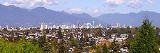
Metro Vancouver is the brand name of the board of the inter-municipal administrative body known as the Greater Vancouver Regional District (GVRD), a regional district in British Columbia
Regional districts of British Columbia
The Canadian province of British Columbia is divided into regional districts. Like counties in other parts of Canada, regional districts serve only to provide municipal services as the local government in areas not incorporated into a municipality, and in certain regional affairs of shared concern...
, Canada. "Greater Vancouver Regional District" is the official name of the regional district and remains in common use.
The Metro Vancouver board governs the affairs of the Greater Vancouver Regional District, which is charged with certain aspects of governance for the metropolitan area surrounding and including the city of Vancouver
Vancouver
Vancouver is a coastal seaport city on the mainland of British Columbia, Canada. It is the hub of Greater Vancouver, which, with over 2.3 million residents, is the third most populous metropolitan area in the country,...
, British Columbia, Canada. The Greater Vancouver Regional District was incorporated on June 29, 1967. Greater Vancouver as a region and name emerged when the newly born City of Vancouver expanded to become larger than the older New Westminster. The territory under Metro Vancouver's authority is essentially synonymous with what is usually meant by the colloquial term "Greater Vancouver", although wilderness and outlying rural regions within the regional district are not generally meant when the term "Greater Vancouver" is used. Statistics Canada
Statistics Canada
Statistics Canada is the Canadian federal government agency commissioned with producing statistics to help better understand Canada, its population, resources, economy, society, and culture. Its headquarters is in Ottawa....
defines the Vancouver CMA (Census Metropolitan Area) as having perfectly coterminal boundaries with the Greater Vancouver Regional District. Although the region's principal city is Vancouver, its administrative offices are located in the City of Burnaby.
Despite the typical equation of the regional district with the metropolitan area and the geographical region, the many Indian Reserve
Indian reserve
In Canada, an Indian reserve is specified by the Indian Act as a "tract of land, the legal title to which is vested in Her Majesty, that has been set apart by Her Majesty for the use and benefit of a band." The Act also specifies that land reserved for the use and benefit of a band which is not...
s in the Greater Vancouver region as well as the University Endowment Lands
University Endowment Lands
The University Endowment Lands is an unincorporated area that lies to the west of the city of Vancouver, British Columbia, Canada surrounding the University of British Columbia...
(UEL) are not part of the representation in the regional district (the UEL is in GVRD Electoral Area 'A', but has its own system of government and is outside the regional district's authority). Other political geographic regions parallel to the regional district are the Lower Mainland
Lower Mainland
The Lower Mainland is a name commonly applied to the region surrounding and including Vancouver, British Columbia, Canada. As of 2007, 2,524,113 people live in the region; sixteen of the province's thirty most populous municipalities are located there.While the term Lower Mainland has been...
region of the Ministry of Environment, the Chilliwack Forest District, the New Westminster Land District
New Westminster Land District
New Westminster Land District is one of 59 Land Districts of British Columbia, Canada, which are the underlying cadastral divisions of that province....
, and the Fraser Health Authority. Schools are not subject to municipal or regional district governance and are administered via the school districts system.
The Greater Vancouver Regional District was established in 1967, following the creation of Greater Vancouver Sewerage and Drainage District (GVSDD) in 1914 and Greater Vancouver Water District (GVWD) in 1926. In 2007, the GVRD board unanimously supported a proposal to the provincial government to change its official name to Metro Vancouver. While the new name took effect in September 2007, the Province declined to amend the Greater Vancouver Regional District's letters patent to change the name to "Metro Vancouver". The name of the physical area governed by the organization remains the Greater Vancouver Regional District.
Municipalities
Thirteen of the province's thirty most populous municipalities are located in Metro Vancouver. The official land area of the district is 2877.36 square kilometres (1,111 sq mi). It is the most densely populated regional district in British Columbia.The Regional District comprises the governments of 21 incorporated municipalities and one unincorporated area. The 21 municipalities are:
| Municipality | Type | Population | Year |
|---|---|---|---|
| Anmore | village | 1,992 | 2007 |
| Belcarra Belcarra, British Columbia See also Belcarra, County Mayo in the Republic of Ireland.Belcarra is a village on the shore of Indian Arm, a side inlet of Burrard Inlet, and is part of Metro Vancouver. It lies northwest of Port Moody and immediately east of the Deep Cove area of North Vancouver, across the waters of Indian Arm... |
village | 701 | 2007 |
| Bowen Island Bowen Island Bowen Island, British Columbia, is an island municipality in Howe Sound, is part of the Greater Vancouver Regional District, and is an island included within the jurisdiction of the Islands Trust . Approximately 6 km wide by 12 km long, the island at its closest point is about 2 km... |
island municipality | 3,551 | 2007 |
| Burnaby | city | 216,336 | 2007 |
| Coquitlam | city | 120,512 | 2007 |
| Delta Delta, British Columbia Delta is a district municipality in British Columbia, and forms part of Metro Vancouver. Located south of Richmond, it is bordered by the Fraser River to the north, the United States to the south and the city of Surrey to the east... |
district municipality | 101,668 | 2007 |
| Langley Langley, British Columbia (city) The City of Langley is a municipality in Metro Vancouver. It lies directly east of the City of Surrey, adjacent to Cloverdale, and surrounded on the north, east and south by Township of Langley.-History:... |
city | 25,134 | 2007 |
| Langley Langley, British Columbia (district municipality) The Township of Langley is a district municipality immediately east of the City of Surrey in southwestern British Columbia, Canada. It extends south from the Fraser River to the U.S. border, and west of the City of Abbotsford... |
district municipality | 100,049 | 2007 |
| Lions Bay | village | 1,394 | 2007 |
| Maple Ridge Maple Ridge, British Columbia Maple Ridge is a District Municipality in British Columbia, located in the northeastern section of Metro Vancouver. Maple Ridge has a population of approximately 68,949.-History:... |
district municipality | 73,248 | 2007 |
| New Westminster | city | 62,607 | 2007 |
| North Vancouver North Vancouver, British Columbia (city) The City of North Vancouver is a waterfront municipality on the north shore of Burrard Inlet, directly across from Vancouver, British Columbia. It is the smallest of the three North Shore municipalities, and the most urbanized as well... |
city | 47,463 | 2007 |
| North Vancouver North Vancouver, British Columbia (district municipality) The District of North Vancouver is a district municipality in British Columbia and is part of the GVRD. It surrounds the City of North Vancouver on three sides.-Geography:The District of North Vancouver is separated from Vancouver by Burrard Inlet... |
district municipality | 86,954 | 2007 |
| Pitt Meadows | city | 16,757 | 2007 |
| Port Coquitlam | city | 55,735 | 2007 |
| Port Moody | city | 30,004 | 2007 |
| Richmond Richmond, British Columbia Richmond is a coastal city, incorporated in the Canadian province of British Columbia. Part of Metro Vancouver, its neighbouring communities are Vancouver and Burnaby to the north, New Westminster to the east, and Delta to the south, while the Strait of Georgia forms its western border... |
city | 186,628 | 2007 |
| Surrey Surrey, British Columbia Surrey is a city in the province of British Columbia, Canada. It is a member municipality of Metro Vancouver, the governing body of the Greater Vancouver Regional District... |
city | 394,976 | 2007 |
| Vancouver Vancouver Vancouver is a coastal seaport city on the mainland of British Columbia, Canada. It is the hub of Greater Vancouver, which, with over 2.3 million residents, is the third most populous metropolitan area in the country,... |
city | 578,041 | 2007 |
| West Vancouver | district municipality | 44,097 | 2007 |
| White Rock White Rock, British Columbia White Rock is a city in British Columbia, Canada, that lies within the Metro Vancouver regional district. It borders Semiahmoo Bay and is surrounded on three sides by the City of Surrey, British Columbia. To the south lies the Semiahmoo First Nation, which is within the city limits of Surrey... |
city | 19,839 | 2007 |
| Electoral Area A Greater Vancouver Electoral Area A, British Columbia Greater Vancouver Electoral Area A is a part of the Greater Vancouver Regional District in British Columbia. It includes several unincorporated areas in the GVRD: the University Endowment Lands and the University of British Columbia, west of the City of Vancouver; Bowyer, Passage, and Barnston... |
unincorporated area | 19,252 | 2007 |
| Greater Vancouver Regional District | regional district | 2,249,725 | 2007 |
Abbotsford
Abbotsford, British Columbia
Abbotsford is a Canadian city located in the Lower Mainland of British Columbia, adjacent to Greater Vancouver. It is the fifth largest municipality in British Columbia, home to 123,864 people . Its Census Metropolitan Area, which includes the District of Mission, is the 23rd largest in Canada,...
is a member for parks purposes only.
Greater Vancouver Regional District Electoral Area A comprises all unincorporated land
Unincorporated area
In law, an unincorporated area is a region of land that is not a part of any municipality.To "incorporate" in this context means to form a municipal corporation, a city, town, or village with its own government. An unincorporated community is usually not subject to or taxed by a municipal government...
within the Regional District boundaries, and includes the University of British Columbia, the University Endowment Lands
University Endowment Lands
The University Endowment Lands is an unincorporated area that lies to the west of the city of Vancouver, British Columbia, Canada surrounding the University of British Columbia...
, and residential areas and isolated dwellings on Howe Sound
Howe Sound
Howe Sound is a roughly triangular sound, actually a network of fjords situated immediately northwest of Vancouver.-Geography:Howe Sound's mouth at the Strait of Georgia is situated between West Vancouver and the Sunshine Coast. The sound is triangular shaped, open on its southeast towards the...
between Lions Bay and Horseshoe Bay, on Indian Arm to the north of Deep Cove and Belcarra/Anmore, and on the west side of Pitt Lake
Pitt Lake
Pitt Lake is the second-largest lake in the Lower Mainland of British Columbia, being about 53.5 square kilometres in area. It is about 25 km long and about 4.5 km wide at its widest, and is also one of the world's largest tidal lakes, its confluence with the Fraser being only a few miles upstream...
to the north of Port Coquitlam. Passage Island and Barnston Island
Barnston Island, British Columbia
Barnston Island is an unincorporated island located in the Greater Vancouver metropolitan area of British Columbia, Canada. Most of the island is part of the Greater Vancouver Electoral Area A; the remainder is Barnston Island Indian Reserve No...
in the Fraser River
Fraser River
The Fraser River is the longest river within British Columbia, Canada, rising at Fraser Pass near Mount Robson in the Rocky Mountains and flowing for , into the Strait of Georgia at the city of Vancouver. It is the tenth longest river in Canada...
and are classified as Regional District Remainders.
There are also seventeen Indian reserve
Indian reserve
In Canada, an Indian reserve is specified by the Indian Act as a "tract of land, the legal title to which is vested in Her Majesty, that has been set apart by Her Majesty for the use and benefit of a band." The Act also specifies that land reserved for the use and benefit of a band which is not...
s within the geographical area that are not subject to governance by the municipalities or the Regional District; they have a combined population of 7,550 (2006).
The cities of Abbotsford
Abbotsford, British Columbia
Abbotsford is a Canadian city located in the Lower Mainland of British Columbia, adjacent to Greater Vancouver. It is the fifth largest municipality in British Columbia, home to 123,864 people . Its Census Metropolitan Area, which includes the District of Mission, is the 23rd largest in Canada,...
and Chilliwack
Chilliwack, British Columbia
Chilliwack is a Canadian city in the Province of British Columbia. It is a predominantly agricultural community with an estimated population of 80,000 people. Chilliwack is the second largest city in the Fraser Valley Regional District after Abbotsford. The city is surrounded by mountains and...
and the district of Mission
Mission, British Columbia
Mission, the core of which was formerly known as Mission City, is a district municipality in the province of British Columbia, Canada. It is situated on the north bank of the Fraser River overlooking the City of Abbotsford and with that city is part of the Central Fraser Valley. Mission is the...
, located to the east, although often linked to Vancouver in promotions and tourism, are part of a separate regional district, the Fraser Valley Regional District
Fraser Valley Regional District
The Fraser Valley Regional District is a regional district in British Columbia, Canada. The FVRD covers an area of 13,361.74 km²...
, though part of the same region, the Lower Mainland
Lower Mainland
The Lower Mainland is a name commonly applied to the region surrounding and including Vancouver, British Columbia, Canada. As of 2007, 2,524,113 people live in the region; sixteen of the province's thirty most populous municipalities are located there.While the term Lower Mainland has been...
. See Greater Vancouver
Greater Vancouver
Greater Vancouver is the metropolitan area centred on the city of Vancouver, British Columbia, Canada, roughly coterminous with the Greater Vancouver Regional District, which is governed by a body known as Metro Vancouver...
for the larger geographic region meant by that term ("Metro Vancouver" refers only to the government of the regional district, and the regional district is not exactly coterminous with the region as such).
Administrative role
The principal function of Metro Vancouver is to administer resources and services which are common across the metropolitan area. These include community planning, water, sewage, drainage, housing, transportation, air quality, and parks.There are three legal entities that operate under the name Metro Vancouver: the Greater Vancouver Water District (GVWD); the Greater Vancouver Sewerage and Drainage District (GVS&DD); and the Greater Vancouver Regional District (GVRD). The Metro Vancouver Housing Corporation is wholly owned by the Greater Vancouver Regional District.
Greater Vancouver Regional Parks oversees the development and maintenance of nineteen regional parks, as well as various nature reserves and greenways. (The regional parks are distinct from municipal parks in that they are typically more "wild" and represent unique geographical zones within the region, such as bog
Bog
A bog, quagmire or mire is a wetland that accumulates acidic peat, a deposit of dead plant material—often mosses or, in Arctic climates, lichens....
s and mature rainforest
Rainforest
Rainforests are forests characterized by high rainfall, with definitions based on a minimum normal annual rainfall of 1750-2000 mm...
s.)
Although the Greater Vancouver Water District comprises a system that covers more than 2,600 km², all the water for the district comes from three sources: the Capilano reservoir
Capilano Lake
Capilano Lake is a lake located in the District of North Vancouver and West Vancouver in British Columbia, Canada. It is a watershed administered by the Metro Vancouver and accounts for approximately 40% of Greater Vancouver's water supply...
, the Seymour reservoir, and the Coquitlam reservoir
Coquitlam Lake
Coquitlam Lake is a reservoir located just north of Coquitlam, British Columbia. It is one of the three main water sources for Metro Vancouver, and also a part of BC Hydro's power generation system...
. Metro Vancouver controls the Cleveland Dam
Cleveland Dam
The Cleveland Dam is a concrete dam at the head of the Capilano River in North Vancouver, British Columbia, Canada that holds back Capilano Lake. Part of the Capilano River Regional Park, it is not used for generating hydroelectricity, but rather for storing a portion of the Lower Mainland's...
on the Capilano reservoir, which supplies 40 percent of the district's water.
One initiative of the Greater Vancouver Sewerage and Drainage District was the Ashcroft Manor Ranch Mega-Landfill
Landfill
A landfill site , is a site for the disposal of waste materials by burial and is the oldest form of waste treatment...
Proposal in Ashcroft, British Columbia, in the Thompson Country
Thompson Country
The Thompson Country, also referred to as The Thompson and in some ways as the Thompson Valley and historically known as the Couteau Country or Couteau District, is a historic geographic region of the Southern Interior of British Columbia, based around the basin of the Thompson River, a tributary...
of the British Columbia Interior
British Columbia Interior
The British Columbia Interior or BC Interior or Interior of British Columbia, usually referred to only as the Interior, is one of the three main regions of the Canadian province of British Columbia, the other two being the Lower Mainland, which comprises the overlapping areas of Greater Vancouver...
, as there is no more room in the Lower Mainland for Metro Vancouver's garbage. A similar project nearby adjacent to the town of Cache Creek, British Columbia
Cache Creek, British Columbia
Cache Creek is a junction community northeast of Vancouver in British Columbia, Canada. It is on the Trans-Canada Highway in the province of British Columbia at its junction with northbound Highway 97...
has almost reached capacity. Environmental concerns about the area's sensitive shrub-steppe
Shrub-steppe
Shrub-steppe is a type of low rainfall natural grassland. Shrub-steppes are distinguishable from deserts, which are too dry to support a noticeable cover of perennial grasses or other shrubs, while the shrub-steppe has sufficient moisture levels to support a cover of perennial grasses and/or...
climate and ecology are strong, while Highland Valley Copper, near Logan Lake
Logan Lake, British Columbia
Logan Lake is a district municipality in the Southern Interior of British Columbia, Canada.It was founded in the 1960s and 70s to support copper, molybdenum and other mineral mining operations located south of the town. The Village of Logan Lake was incorporated in November 1970, and was...
, has offered the use of its mine-pit instead. Other GVSDD landfill locations serving the regional district in the past have been in the Fraser Mills
Fraser Mills
Fraser Mills is a neighbourhood and formerly separate village municipality in the southwestern part of Coquitlam, British Columbia.Located on the northern shore of the Fraser River, the area was originally the site of a sawmill. The mill was known at first as the Ross McLaren Mill and opened in...
area, between the Trans-Canada Highway and the Fraser, and at Port Mann, beneath the south foot of the ort Mann Bridge.
Demographics

In 2006, Metro Vancouver had a population of 2,116,581 living in 870,992 dwellings
House
A house is a building or structure that has the ability to be occupied for dwelling by human beings or other creatures. The term house includes many kinds of different dwellings ranging from rudimentary huts of nomadic tribes to free standing individual structures...
. The regional district has a land area of 2877.36 km² (1,111 sq mi) and a population density of 735.6 /km2.
Metro Vancouver has a large ethnic minority population. The 2006 census showed that nearly 41.7% of the population were of visible minority origin, the largest visible minority group being Chinese, followed by South Asians. Other prominent groups include Filipinos
Filipino Canadian
Filipino Canadians are Canadians of Filipino ancestry. Filipino-Canadians are the fourth-largest subgroup of the Overseas Filipinos.Canada only had a small population of Filipinos until the late 20th century. To date, there are currently around 400,000 Filipino Canadians in Canada, most of them...
, Koreans, Japanese, Southeast Asian, West Asian, and Latin Americans
Latin Americans
Latin Americans are the citizens of the Latin American countries and dependencies. Latin American countries are multi-ethnic, home to people of different ethnic and national backgrounds. As a result, some Latin Americans don't take their nationality as an ethnicity, but identify themselves with...
. British Columbia
British Columbia
British Columbia is the westernmost of Canada's provinces and is known for its natural beauty, as reflected in its Latin motto, Splendor sine occasu . Its name was chosen by Queen Victoria in 1858...
is Canada's most ethnically diverse province.
See also
- Greater VancouverGreater VancouverGreater Vancouver is the metropolitan area centred on the city of Vancouver, British Columbia, Canada, roughly coterminous with the Greater Vancouver Regional District, which is governed by a body known as Metro Vancouver...
- Greater Victoria, British ColumbiaGreater Victoria, British ColumbiaGreater Victoria is located in British Columbia, Canada, on the southern tip of Vancouver Island. It is a cultural rather than political entity, usually defined as the thirteen easternmost municipalities of the Capital Regional District on Vancouver Island but also includes adjoining areas and...
- Capital Regional District