

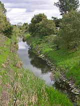
Piner Creek
Encyclopedia
Piner Creek is a stream
in northeast Santa Rosa
, California
, United States
(38°27′40"N 122°45′05"W) which originates as an outlet of Fountaingrove Lake
. Piner Creek discharges to Santa Rosa Creek
which in turn joins the Laguna de Santa Rosa
. The upper reaches in the foothills
of the Mayacamas Mountains are at elevations of 200 to 300 feet (60 to 90 meters), while the lower and middle reaches are located on the Santa Rosa Plain at elevations of between the 110- and 140-foot (33- and 43-meter) contours
; therefore, these lower reaches have a gradient of about 1:250 toward the southwest. Geologic studies in the lower and middle reaches of Piner Creek indicate groundwater
levels ranging from three to 15 feet (one to 5 meters) below the surface. Prior to extensive urban development of the middle and lower reaches, the landscape earlier bore extensive agricultural uses including plum
orchard
s, which fruit was subsequently processed for prune
s.
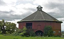
The Piner Creek watershed
consists of 4048 acre (16.4 km²), approximately three-fourths of which lies within the municipal boundaries of the city of Santa Rosa
. About one-third of the watershed is developed as residential use, and about one-sixth of the land is open space, recreation and agricultural usage. One of the early surviving architectural features of Sonoma County is within the Piner Creek catchment basin: A well preserved Round Barn, constructed in 1899, a testament to the 19th century pasturage
uses within this watershed.
 Piner Creek originates in the lower Mayacmas Mountains at Fountaingrove Lake
. From its outlet at Fountaingrove Lake, Piner Creek flows down a relatively steep gradient, initially over a riprap
lined channel, which has been modified in association with some alterations to lower Fountaingrove Lake. Thence Piner Creek flows northerly of an upscale modern office park before crossing under Redwood Highway and U.S. Highway 101. West of the U.S. 101 Freeway, Piner Creek winds through a retail
and commercial/industrial
area, before crossing under Piner Road near Coffey Lane; in this reach there is a large historic release to groundwater
of solvent
from manufacturing uses stemming back to the 1970s and 1980s.
Water quality of Piner Creek is characterized by pH
levels that are mildly basic
, with upper reach pH levels about 8.5, declining to lower reach levels at 7.8 just above the discharge to Santa Rosa Creek. It is interesting to note that the headwaters soils are typically of pH about 6.9. Water quality of Piner Creek is generally low in turbidity
, except for highest flow periods resulting from heavy rains; the water is free from odor
. Springtime water temperatures are typically in the range of 60 to 65 degrees Fahrenheit (16 to 18 degrees Celsius).
Piner Creek terminates at its confluence with Santa Rosa Creek
, which watercourse
discharges to the Laguna de Santa Rosa
; the Laguna de Santa Rosa ultimately forms a confluence with the Russian River
, which flows into the Pacific Ocean
.
 As recently as the Miocene
period, twelve million years ago, the entire watershed of Piner Creek was on the floor of the Pacific Ocean
. After significant volcanic uplift and tectonic movement, the headwaters region of the Mayacmas Mountains emerged above the ocean. Piner Creek was one of the drainages that began to drain the new landmass, in formation of the eventual Santa Rosa Plain, through which the middle and lower reaches of Piner Creek flow. Occasional basalt
ic outcrop
s are seen in the upper reach of Piner Creek, betraying the volcanic origin of the Mayacmas Mountains.
The upper reach of Piner Creek watershed is characterized by presence of Goulding cobbly clay
loam
soil; this soil has slopes of up to 15 percent and is subject to moderate erosive
potential. The actual soil depth is typically only about 20 inches (50.8 cm) and may contain up to 25 percent cobblestones. Historic use of this soil has been for grazing
. As the stream approaches the Santa Rosa Plain immediately east of U.S Highway 101, slopes diminish to a gradient of five to 15 percent and the predominant soil type is Felta very gravel
ly loam. This Felta soil is characterized by an upper surface grayish-brown color and texture of a fine, sticky and plastic nature.
West of U.S. Highway 101, Piner Creek flows over the Santa Rosa Plain at gradients of less than two percent. Here the predominant soil type is Zamora silt
y clay loam, which has been deposited as an alluvial fan as the floodplain
formed. The upper soil surface of the Zamora material is grayish-brown hard, firm, sticky and plastic. Permeability is moderately slow and fertility is high for these lower reach soils, which has resulted in historic orchard use and present day vineyard
s.
evaluation of Piner Creek has been conducted along with a number of other streams within the Laguna de Santa Rosa watershed. Habitat value of Piner Creek was found to be Fair compared to higher values scored by Matanzas Creek
and Brush Creek
and lower values scored by Colgan Creek. Most of the watercourse has been modified to accommodate urban development within Santa Rosa, and some alterations have been conducted to achieve higher levels of flood control
. The dominant tree along the banks of Piner Creek is the Coast live oak
, Quercus agrifolia; within the streambed, a large number of Cattail, Typha latifolia
, stands are observed. A considerable number of bird species
are found along the stream banks of Piner Creek.
Based upon benthic macroinvertebrate sampling in Piner Creek, a low fauna
l diversity
was found; moreover a declining trend of such biodiversity
was noted over the period 2000 to 2003. In comparison with other streams of the Santa Rosa Creek watershed, Piner Creek was assessed to have above average epifaunal cover, riffle frequency and silt
ation characteristics. The high population level of tubificid
s in Piner Creek indicate the presence of excessive organic loading, mostly due to high nitrate
and phosphate
runoff
from urban uses (and possible reduced dissolved oxygen levels).
Stream
A stream is a body of water with a current, confined within a bed and stream banks. Depending on its locale or certain characteristics, a stream may be referred to as a branch, brook, beck, burn, creek, "crick", gill , kill, lick, rill, river, syke, bayou, rivulet, streamage, wash, run or...
in northeast Santa Rosa
Santa Rosa, California
Santa Rosa is the county seat of Sonoma County, California, United States. The 2010 census reported a population of 167,815. Santa Rosa is the largest city in California's Wine Country and fifth largest city in the San Francisco Bay Area, after San Jose, San Francisco, Oakland, and Fremont and 26th...
, California
California
California is a state located on the West Coast of the United States. It is by far the most populous U.S. state, and the third-largest by land area...
, United States
United States
The United States of America is a federal constitutional republic comprising fifty states and a federal district...
(38°27′40"N 122°45′05"W) which originates as an outlet of Fountaingrove Lake
Fountaingrove Lake
Fountaingrove Lake is a reservoir in the city of Santa Rosa, California, United States. Formed by the Fountaingrove Dam, the lake is fed from the east by Piner Creek, which is also the lake's sole outlet.Fountaingrove Dam is an earthen dam built in 1953...
. Piner Creek discharges to Santa Rosa Creek
Santa Rosa Creek
Santa Rosa Creek is a 22 mile long stream in Sonoma County, California which rises on Hood Mountain and discharges to the Laguna de Santa Rosa by way of the Santa Rosa Flood Control Channel...
which in turn joins the Laguna de Santa Rosa
Laguna de Santa Rosa
The Laguna de Santa Rosa is a long wetland complex that drains a 254-square mile watershed encompassing most of the Santa Rosa Plain in Sonoma County, California, USA.-Description:...
. The upper reaches in the foothills
Foothills
Foothills are geographically defined as gradual increases in elevation at the base of a mountain range. They are a transition zone between plains and low relief hills to the adjacent topographically high mountains.-Examples:...
of the Mayacamas Mountains are at elevations of 200 to 300 feet (60 to 90 meters), while the lower and middle reaches are located on the Santa Rosa Plain at elevations of between the 110- and 140-foot (33- and 43-meter) contours
Contour line
A contour line of a function of two variables is a curve along which the function has a constant value. In cartography, a contour line joins points of equal elevation above a given level, such as mean sea level...
; therefore, these lower reaches have a gradient of about 1:250 toward the southwest. Geologic studies in the lower and middle reaches of Piner Creek indicate groundwater
Groundwater
Groundwater is water located beneath the ground surface in soil pore spaces and in the fractures of rock formations. A unit of rock or an unconsolidated deposit is called an aquifer when it can yield a usable quantity of water. The depth at which soil pore spaces or fractures and voids in rock...
levels ranging from three to 15 feet (one to 5 meters) below the surface. Prior to extensive urban development of the middle and lower reaches, the landscape earlier bore extensive agricultural uses including plum
Plum
A plum or gage is a stone fruit tree in the genus Prunus, subgenus Prunus. The subgenus is distinguished from other subgenera in the shoots having a terminal bud and solitary side buds , the flowers in groups of one to five together on short stems, and the fruit having a groove running down one...
orchard
Orchard
An orchard is an intentional planting of trees or shrubs that is maintained for food production. Orchards comprise fruit or nut-producing trees which are grown for commercial production. Orchards are also sometimes a feature of large gardens, where they serve an aesthetic as well as a productive...
s, which fruit was subsequently processed for prune
Prune
A prune is any of various plum cultivars, mostly Prunus domestica or European Plum, sold as fresh or dried fruit. The dried fruit is also referred to as a dried plum...
s.
The Piner Creek watershed
Drainage basin
A drainage basin is an extent or an area of land where surface water from rain and melting snow or ice converges to a single point, usually the exit of the basin, where the waters join another waterbody, such as a river, lake, reservoir, estuary, wetland, sea, or ocean...
consists of 4048 acre (16.4 km²), approximately three-fourths of which lies within the municipal boundaries of the city of Santa Rosa
Santa Rosa, California
Santa Rosa is the county seat of Sonoma County, California, United States. The 2010 census reported a population of 167,815. Santa Rosa is the largest city in California's Wine Country and fifth largest city in the San Francisco Bay Area, after San Jose, San Francisco, Oakland, and Fremont and 26th...
. About one-third of the watershed is developed as residential use, and about one-sixth of the land is open space, recreation and agricultural usage. One of the early surviving architectural features of Sonoma County is within the Piner Creek catchment basin: A well preserved Round Barn, constructed in 1899, a testament to the 19th century pasturage
Pasture
Pasture is land used for grazing. Pasture lands in the narrow sense are enclosed tracts of farmland, grazed by domesticated livestock, such as horses, cattle, sheep or swine. The vegetation of tended pasture, forage, consists mainly of grasses, with an interspersion of legumes and other forbs...
uses within this watershed.
Hydrology
Fountaingrove Lake
Fountaingrove Lake is a reservoir in the city of Santa Rosa, California, United States. Formed by the Fountaingrove Dam, the lake is fed from the east by Piner Creek, which is also the lake's sole outlet.Fountaingrove Dam is an earthen dam built in 1953...
. From its outlet at Fountaingrove Lake, Piner Creek flows down a relatively steep gradient, initially over a riprap
Riprap
Riprap — also known as rip rap, rubble, shot rock or rock armour or "Rip-rap" — is rock or other material used to armor shorelines, streambeds, bridge abutments, pilings and other shoreline structures against scour, water or ice erosion.It is made from a variety of rock types, commonly granite or...
lined channel, which has been modified in association with some alterations to lower Fountaingrove Lake. Thence Piner Creek flows northerly of an upscale modern office park before crossing under Redwood Highway and U.S. Highway 101. West of the U.S. 101 Freeway, Piner Creek winds through a retail
Retail
Retail consists of the sale of physical goods or merchandise from a fixed location, such as a department store, boutique or kiosk, or by mail, in small or individual lots for direct consumption by the purchaser. Retailing may include subordinated services, such as delivery. Purchasers may be...
and commercial/industrial
Industry
Industry refers to the production of an economic good or service within an economy.-Industrial sectors:There are four key industrial economic sectors: the primary sector, largely raw material extraction industries such as mining and farming; the secondary sector, involving refining, construction,...
area, before crossing under Piner Road near Coffey Lane; in this reach there is a large historic release to groundwater
Groundwater
Groundwater is water located beneath the ground surface in soil pore spaces and in the fractures of rock formations. A unit of rock or an unconsolidated deposit is called an aquifer when it can yield a usable quantity of water. The depth at which soil pore spaces or fractures and voids in rock...
of solvent
Solvent
A solvent is a liquid, solid, or gas that dissolves another solid, liquid, or gaseous solute, resulting in a solution that is soluble in a certain volume of solvent at a specified temperature...
from manufacturing uses stemming back to the 1970s and 1980s.
Water quality of Piner Creek is characterized by pH
PH
In chemistry, pH is a measure of the acidity or basicity of an aqueous solution. Pure water is said to be neutral, with a pH close to 7.0 at . Solutions with a pH less than 7 are said to be acidic and solutions with a pH greater than 7 are basic or alkaline...
levels that are mildly basic
Base (chemistry)
For the term in genetics, see base A base in chemistry is a substance that can accept hydrogen ions or more generally, donate electron pairs. A soluble base is referred to as an alkali if it contains and releases hydroxide ions quantitatively...
, with upper reach pH levels about 8.5, declining to lower reach levels at 7.8 just above the discharge to Santa Rosa Creek. It is interesting to note that the headwaters soils are typically of pH about 6.9. Water quality of Piner Creek is generally low in turbidity
Turbidity
Turbidity is the cloudiness or haziness of a fluid caused by individual particles that are generally invisible to the naked eye, similar to smoke in air. The measurement of turbidity is a key test of water quality....
, except for highest flow periods resulting from heavy rains; the water is free from odor
Odor
An odor or odour is caused by one or more volatilized chemical compounds, generally at a very low concentration, that humans or other animals perceive by the sense of olfaction. Odors are also commonly called scents, which can refer to both pleasant and unpleasant odors...
. Springtime water temperatures are typically in the range of 60 to 65 degrees Fahrenheit (16 to 18 degrees Celsius).
Piner Creek terminates at its confluence with Santa Rosa Creek
Santa Rosa Creek
Santa Rosa Creek is a 22 mile long stream in Sonoma County, California which rises on Hood Mountain and discharges to the Laguna de Santa Rosa by way of the Santa Rosa Flood Control Channel...
, which watercourse
Watercourse
A watercourse is any flowing body of water. These include rivers, streams, anabranches, and so forth.-See also:* physical geography* Environmental flow* Waterway* Hydrology* Wadi-External links:...
discharges to the Laguna de Santa Rosa
Laguna de Santa Rosa
The Laguna de Santa Rosa is a long wetland complex that drains a 254-square mile watershed encompassing most of the Santa Rosa Plain in Sonoma County, California, USA.-Description:...
; the Laguna de Santa Rosa ultimately forms a confluence with the Russian River
Russian River (California)
The Russian River, a southward-flowing river, drains of Sonoma and Mendocino counties in Northern California. With an annual average discharge of approximately , it is the second largest river flowing through the nine county Greater San Francisco Bay Area with a mainstem 110 miles ...
, which flows into the Pacific Ocean
Pacific Ocean
The Pacific Ocean is the largest of the Earth's oceanic divisions. It extends from the Arctic in the north to the Southern Ocean in the south, bounded by Asia and Australia in the west, and the Americas in the east.At 165.2 million square kilometres in area, this largest division of the World...
.
Geology
Miocene
The Miocene is a geological epoch of the Neogene Period and extends from about . The Miocene was named by Sir Charles Lyell. Its name comes from the Greek words and and means "less recent" because it has 18% fewer modern sea invertebrates than the Pliocene. The Miocene follows the Oligocene...
period, twelve million years ago, the entire watershed of Piner Creek was on the floor of the Pacific Ocean
Pacific Ocean
The Pacific Ocean is the largest of the Earth's oceanic divisions. It extends from the Arctic in the north to the Southern Ocean in the south, bounded by Asia and Australia in the west, and the Americas in the east.At 165.2 million square kilometres in area, this largest division of the World...
. After significant volcanic uplift and tectonic movement, the headwaters region of the Mayacmas Mountains emerged above the ocean. Piner Creek was one of the drainages that began to drain the new landmass, in formation of the eventual Santa Rosa Plain, through which the middle and lower reaches of Piner Creek flow. Occasional basalt
Basalt
Basalt is a common extrusive volcanic rock. It is usually grey to black and fine-grained due to rapid cooling of lava at the surface of a planet. It may be porphyritic containing larger crystals in a fine matrix, or vesicular, or frothy scoria. Unweathered basalt is black or grey...
ic outcrop
Outcrop
An outcrop is a visible exposure of bedrock or ancient superficial deposits on the surface of the Earth. -Features:Outcrops do not cover the majority of the Earth's land surface because in most places the bedrock or superficial deposits are covered by a mantle of soil and vegetation and cannot be...
s are seen in the upper reach of Piner Creek, betraying the volcanic origin of the Mayacmas Mountains.
The upper reach of Piner Creek watershed is characterized by presence of Goulding cobbly clay
Clay
Clay is a general term including many combinations of one or more clay minerals with traces of metal oxides and organic matter. Geologic clay deposits are mostly composed of phyllosilicate minerals containing variable amounts of water trapped in the mineral structure.- Formation :Clay minerals...
loam
Loam
Loam is soil composed of sand, silt, and clay in relatively even concentration . Loam soils generally contain more nutrients and humus than sandy soils, have better infiltration and drainage than silty soils, and are easier to till than clay soils...
soil; this soil has slopes of up to 15 percent and is subject to moderate erosive
Erosion
Erosion is when materials are removed from the surface and changed into something else. It only works by hydraulic actions and transport of solids in the natural environment, and leads to the deposition of these materials elsewhere...
potential. The actual soil depth is typically only about 20 inches (50.8 cm) and may contain up to 25 percent cobblestones. Historic use of this soil has been for grazing
Grazing
Grazing generally describes a type of feeding, in which a herbivore feeds on plants , and also on other multicellular autotrophs...
. As the stream approaches the Santa Rosa Plain immediately east of U.S Highway 101, slopes diminish to a gradient of five to 15 percent and the predominant soil type is Felta very gravel
Gravel
Gravel is composed of unconsolidated rock fragments that have a general particle size range and include size classes from granule- to boulder-sized fragments. Gravel can be sub-categorized into granule and cobble...
ly loam. This Felta soil is characterized by an upper surface grayish-brown color and texture of a fine, sticky and plastic nature.
West of U.S. Highway 101, Piner Creek flows over the Santa Rosa Plain at gradients of less than two percent. Here the predominant soil type is Zamora silt
Silt
Silt is granular material of a size somewhere between sand and clay whose mineral origin is quartz and feldspar. Silt may occur as a soil or as suspended sediment in a surface water body...
y clay loam, which has been deposited as an alluvial fan as the floodplain
Floodplain
A floodplain, or flood plain, is a flat or nearly flat land adjacent a stream or river that stretches from the banks of its channel to the base of the enclosing valley walls and experiences flooding during periods of high discharge...
formed. The upper soil surface of the Zamora material is grayish-brown hard, firm, sticky and plastic. Permeability is moderately slow and fertility is high for these lower reach soils, which has resulted in historic orchard use and present day vineyard
Vineyard
A vineyard is a plantation of grape-bearing vines, grown mainly for winemaking, but also raisins, table grapes and non-alcoholic grape juice...
s.
Ecology
Formal habitatHabitat
* Habitat , a place where a species lives and grows*Human habitat, a place where humans live, work or play** Space habitat, a space station intended as a permanent settlement...
evaluation of Piner Creek has been conducted along with a number of other streams within the Laguna de Santa Rosa watershed. Habitat value of Piner Creek was found to be Fair compared to higher values scored by Matanzas Creek
Matanzas Creek
Matanzas Creek is an year-round stream in Sonoma County, California, United States, a tributary of Santa Rosa Creek.-Course:Matanzas Creek springs from the northern slope of Sonoma Mountain and flows northward into Bennett Valley to join the South Fork Matanzas Creek...
and Brush Creek
Brush Creek (Sonoma County, California)
Brush Creek or Rincon Creek is a tributary of Santa Rosa Creek in Sonoma County, California. Brush Creek rises in the southern slopes of the Mayacamas Mountains within Sonoma County. The lower reach of the creek is a suburban medium density residential area in the city of Santa Rosa, and that...
and lower values scored by Colgan Creek. Most of the watercourse has been modified to accommodate urban development within Santa Rosa, and some alterations have been conducted to achieve higher levels of flood control
Flood control
In communications, flood control is a feature of many communication protocols designed to prevent overwhelming of a destination receiver. Such controls can be implemented either in software or in hardware, and will often request that the message be resent after the receiver has finished...
. The dominant tree along the banks of Piner Creek is the Coast live oak
Coast Live Oak
Quercus agrifolia, the Coast Live Oak, is an evergreen oak , native to the California Floristic Province. It grows west of the Sierra Nevada from Mendocino County, California, south to northern Baja California in Mexico. It is classified in the red oak section Quercus agrifolia, the Coast Live Oak,...
, Quercus agrifolia; within the streambed, a large number of Cattail, Typha latifolia
Typha latifolia
Typha latifolia is a perennial herbaceous plant in the genus Typha. It is found as a native plant species in North and South America, Europe, Eurasia, and Africa...
, stands are observed. A considerable number of bird species
Species
In biology, a species is one of the basic units of biological classification and a taxonomic rank. A species is often defined as a group of organisms capable of interbreeding and producing fertile offspring. While in many cases this definition is adequate, more precise or differing measures are...
are found along the stream banks of Piner Creek.
Based upon benthic macroinvertebrate sampling in Piner Creek, a low fauna
Fauna
Fauna or faunæ is all of the animal life of any particular region or time. The corresponding term for plants is flora.Zoologists and paleontologists use fauna to refer to a typical collection of animals found in a specific time or place, e.g. the "Sonoran Desert fauna" or the "Burgess shale fauna"...
l diversity
Biodiversity
Biodiversity is the degree of variation of life forms within a given ecosystem, biome, or an entire planet. Biodiversity is a measure of the health of ecosystems. Biodiversity is in part a function of climate. In terrestrial habitats, tropical regions are typically rich whereas polar regions...
was found; moreover a declining trend of such biodiversity
Biodiversity
Biodiversity is the degree of variation of life forms within a given ecosystem, biome, or an entire planet. Biodiversity is a measure of the health of ecosystems. Biodiversity is in part a function of climate. In terrestrial habitats, tropical regions are typically rich whereas polar regions...
was noted over the period 2000 to 2003. In comparison with other streams of the Santa Rosa Creek watershed, Piner Creek was assessed to have above average epifaunal cover, riffle frequency and silt
Silt
Silt is granular material of a size somewhere between sand and clay whose mineral origin is quartz and feldspar. Silt may occur as a soil or as suspended sediment in a surface water body...
ation characteristics. The high population level of tubificid
Tubificidae
The Naididae are a family of clitellate oligochaete worms like the sludge worm, Tubifex tubifex. They are key components of the benthic communities of many freshwater and marine ecosystems....
s in Piner Creek indicate the presence of excessive organic loading, mostly due to high nitrate
Nitrate
The nitrate ion is a polyatomic ion with the molecular formula NO and a molecular mass of 62.0049 g/mol. It is the conjugate base of nitric acid, consisting of one central nitrogen atom surrounded by three identically-bonded oxygen atoms in a trigonal planar arrangement. The nitrate ion carries a...
and phosphate
Phosphate
A phosphate, an inorganic chemical, is a salt of phosphoric acid. In organic chemistry, a phosphate, or organophosphate, is an ester of phosphoric acid. Organic phosphates are important in biochemistry and biogeochemistry or ecology. Inorganic phosphates are mined to obtain phosphorus for use in...
runoff
Surface runoff
Surface runoff is the water flow that occurs when soil is infiltrated to full capacity and excess water from rain, meltwater, or other sources flows over the land. This is a major component of the water cycle. Runoff that occurs on surfaces before reaching a channel is also called a nonpoint source...
from urban uses (and possible reduced dissolved oxygen levels).
See also
- Flood controlFlood controlIn communications, flood control is a feature of many communication protocols designed to prevent overwhelming of a destination receiver. Such controls can be implemented either in software or in hardware, and will often request that the message be resent after the receiver has finished...
- HikingHikingHiking is an outdoor activity which consists of walking in natural environments, often in mountainous or other scenic terrain. People often hike on hiking trails. It is such a popular activity that there are numerous hiking organizations worldwide. The health benefits of different types of hiking...
- List of watercourses in the San Francisco Bay Area
- MiwokMiwokMiwok can refer to any one of four linguistically related groups of Native Americans, native to Northern California, who spoke one of the Miwokan languages in the Utian family...