
.gif)
Brush Creek (Sonoma County, California)
Encyclopedia
Brush Creek or Rincon Creek is a tributary of Santa Rosa Creek
in Sonoma County, California
. Brush Creek rises in the southern slopes of the Mayacamas Mountains within Sonoma County. The lower reach of the creek is a suburban medium density residential area in the city of Santa Rosa
, and that reach of Brush Creek has been restored during the 1990s under a U.S. Environmental Protection Agency grant to promote steelhead migration and spawning
. Further restoration and incorporation into city-wide park planning is currently underway as of 2006. The location of the confluence with Santa Rosa Creek is particularly noteworthy, since it was a locus of prehistoric life as a village
of the Pomo people
and a scenic geologic feature of massive flat boulder outcrop
s within the stream channel.
Brush Creek is a watercourse of approximately three miles in length that drains the area known as Rincon Valley in north Santa Rosa and the outlying unincorporated areas. The stream is shown on U.S. Geological Survey topographic maps as Rincon Creek. On current maps, Rincon Creek is a tributary
that forms a confluence with Brush Creek approximately four kilometers upstream from the mouth of Brush Creek (near Montecito Boulevard). Thus today's nomenclature makes Rincon Creek essentially the west fork of upper Brush Creek.
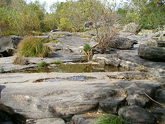 The Flat Rocks feature at the confluence with Santa Rosa Creek was an important element of the prehistoric Pomo village at this site and is currently a picturesque protected area for trail hikers to enjoy. Immediately above the confluence is a modified channel that was designed to allow encroachment by residential development. The open channel has an obvious geometric form where banks have been steepened from the natural original contours; nevertheless, there is considerable riparian vegetation
of Arroyo willow and Broad-leaf cattail (Typha latifolia
). Chief native trees along the banks are Coast live oak (Quercus agrifolia) and Garry oak (Quercus garryana).
Low flows at the end of summer amount to no more than a few cubic feet (50-100 liters) per second; however, after one of the first rains of autumn of approximately 1 in (3 cm), the flow increases to about 120 cu ft (3 m³) per second. Substantial energy dissipation
is achieved by the willows and cattails that choke the creek in this reach. The sides are partially armored with asphalt
to achieve stabilization of the unnatural slope and to minimize scouring and erosion
. In this reach of Brush Creek, Ducker Creek joins from the east and a west fork of Brush Creek forms a confluence somewhat higher from the west.
Soils comprising the streambed of upper and lower reaches are classified as the riverwash series in the U.S. Soil Conservation Service Classification System. These materials according to the U.S. Department of Agriculture, consist of very recent deposition of gravel
and silt
alluvium along streams. Layering of soils and gravels brought in from higher elevations has resulted to form the streambed.
 The upper reach may be defined as that portion of the watershed
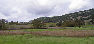
above Montecito Boulevard, most of which is in the unincorporated area of Sonoma County. In these reaches the creek has little modification, save for residential development along Anderson Drive which encroaches into the riparian area. Thus there are no flood control channel improvements, other than the Middle Fork Brush Creek reservoir constructed near Saddle Creek Drive. Above Badger Road there is a dam across Brush Creek, forming this small reservoir
. Headwaters of Brush Creek flow into the reservoir from two forks. There is virtually no public access to the creek or reservoir in the upper reach. There is less cattail vegetation and more mature Garry oaks and Valley oak
s in this reach. Above Baird the landscape turns into chiefly agricultural grazing
land in the lower foothills
of the Mayacmas western slopes.
Santa Rosa Creek
Santa Rosa Creek is a 22 mile long stream in Sonoma County, California which rises on Hood Mountain and discharges to the Laguna de Santa Rosa by way of the Santa Rosa Flood Control Channel...
in Sonoma County, California
Sonoma County, California
Sonoma County, located on the northern coast of the U.S. state of California, is the largest and northernmost of the nine San Francisco Bay Area counties. Its population at the 2010 census was 483,878. Its largest city and county seat is Santa Rosa....
. Brush Creek rises in the southern slopes of the Mayacamas Mountains within Sonoma County. The lower reach of the creek is a suburban medium density residential area in the city of Santa Rosa
Santa Rosa, California
Santa Rosa is the county seat of Sonoma County, California, United States. The 2010 census reported a population of 167,815. Santa Rosa is the largest city in California's Wine Country and fifth largest city in the San Francisco Bay Area, after San Jose, San Francisco, Oakland, and Fremont and 26th...
, and that reach of Brush Creek has been restored during the 1990s under a U.S. Environmental Protection Agency grant to promote steelhead migration and spawning
Spawn (biology)
Spawn refers to the eggs and sperm released or deposited, usually into water, by aquatic animals. As a verb, spawn refers to the process of releasing the eggs and sperm, also called spawning...
. Further restoration and incorporation into city-wide park planning is currently underway as of 2006. The location of the confluence with Santa Rosa Creek is particularly noteworthy, since it was a locus of prehistoric life as a village
Village
A village is a clustered human settlement or community, larger than a hamlet with the population ranging from a few hundred to a few thousand , Though often located in rural areas, the term urban village is also applied to certain urban neighbourhoods, such as the West Village in Manhattan, New...
of the Pomo people
Pomo people
The Pomo people are an indigenous peoples of California. The historic Pomo territory in northern California was large, bordered by the Pacific Coast to the west, extending inland to Clear Lake, and mainly between Cleone and Duncans Point...
and a scenic geologic feature of massive flat boulder outcrop
Outcrop
An outcrop is a visible exposure of bedrock or ancient superficial deposits on the surface of the Earth. -Features:Outcrops do not cover the majority of the Earth's land surface because in most places the bedrock or superficial deposits are covered by a mantle of soil and vegetation and cannot be...
s within the stream channel.
Brush Creek is a watercourse of approximately three miles in length that drains the area known as Rincon Valley in north Santa Rosa and the outlying unincorporated areas. The stream is shown on U.S. Geological Survey topographic maps as Rincon Creek. On current maps, Rincon Creek is a tributary
Tributary
A tributary or affluent is a stream or river that flows into a main stem river or a lake. A tributary does not flow directly into a sea or ocean...
that forms a confluence with Brush Creek approximately four kilometers upstream from the mouth of Brush Creek (near Montecito Boulevard). Thus today's nomenclature makes Rincon Creek essentially the west fork of upper Brush Creek.
Lower reach and confluence with Santa Rosa Creek
Vegetation
Vegetation is a general term for the plant life of a region; it refers to the ground cover provided by plants. It is a general term, without specific reference to particular taxa, life forms, structure, spatial extent, or any other specific botanical or geographic characteristics. It is broader...
of Arroyo willow and Broad-leaf cattail (Typha latifolia
Typha latifolia
Typha latifolia is a perennial herbaceous plant in the genus Typha. It is found as a native plant species in North and South America, Europe, Eurasia, and Africa...
). Chief native trees along the banks are Coast live oak (Quercus agrifolia) and Garry oak (Quercus garryana).
Low flows at the end of summer amount to no more than a few cubic feet (50-100 liters) per second; however, after one of the first rains of autumn of approximately 1 in (3 cm), the flow increases to about 120 cu ft (3 m³) per second. Substantial energy dissipation
Dissipation
In physics, dissipation embodies the concept of a dynamical system where important mechanical models, such as waves or oscillations, lose energy over time, typically from friction or turbulence. The lost energy converts into heat, which raises the temperature of the system. Such systems are called...
is achieved by the willows and cattails that choke the creek in this reach. The sides are partially armored with asphalt
Asphalt
Asphalt or , also known as bitumen, is a sticky, black and highly viscous liquid or semi-solid that is present in most crude petroleums and in some natural deposits, it is a substance classed as a pitch...
to achieve stabilization of the unnatural slope and to minimize scouring and erosion
Erosion
Erosion is when materials are removed from the surface and changed into something else. It only works by hydraulic actions and transport of solids in the natural environment, and leads to the deposition of these materials elsewhere...
. In this reach of Brush Creek, Ducker Creek joins from the east and a west fork of Brush Creek forms a confluence somewhat higher from the west.
Soils comprising the streambed of upper and lower reaches are classified as the riverwash series in the U.S. Soil Conservation Service Classification System. These materials according to the U.S. Department of Agriculture, consist of very recent deposition of gravel
Gravel
Gravel is composed of unconsolidated rock fragments that have a general particle size range and include size classes from granule- to boulder-sized fragments. Gravel can be sub-categorized into granule and cobble...
and silt
Silt
Silt is granular material of a size somewhere between sand and clay whose mineral origin is quartz and feldspar. Silt may occur as a soil or as suspended sediment in a surface water body...
alluvium along streams. Layering of soils and gravels brought in from higher elevations has resulted to form the streambed.
Upper reach
Drainage basin
A drainage basin is an extent or an area of land where surface water from rain and melting snow or ice converges to a single point, usually the exit of the basin, where the waters join another waterbody, such as a river, lake, reservoir, estuary, wetland, sea, or ocean...
above Montecito Boulevard, most of which is in the unincorporated area of Sonoma County. In these reaches the creek has little modification, save for residential development along Anderson Drive which encroaches into the riparian area. Thus there are no flood control channel improvements, other than the Middle Fork Brush Creek reservoir constructed near Saddle Creek Drive. Above Badger Road there is a dam across Brush Creek, forming this small reservoir
Reservoir
A reservoir , artificial lake or dam is used to store water.Reservoirs may be created in river valleys by the construction of a dam or may be built by excavation in the ground or by conventional construction techniques such as brickwork or cast concrete.The term reservoir may also be used to...
. Headwaters of Brush Creek flow into the reservoir from two forks. There is virtually no public access to the creek or reservoir in the upper reach. There is less cattail vegetation and more mature Garry oaks and Valley oak
Valley Oak
Quercus lobata, commonly called the Valley oak, grows into the largest of North American oaks. It is endemic to California, growing in the interior valleys and foothills. Mature specimens may attain an age of up to 600 years. This deciduous oak requires year-round access to groundwater.Its thick,...
s in this reach. Above Baird the landscape turns into chiefly agricultural grazing
Grazing
Grazing generally describes a type of feeding, in which a herbivore feeds on plants , and also on other multicellular autotrophs...
land in the lower foothills
Foothills
Foothills are geographically defined as gradual increases in elevation at the base of a mountain range. They are a transition zone between plains and low relief hills to the adjacent topographically high mountains.-Examples:...
of the Mayacmas western slopes.