
Numbered street
Encyclopedia
A numbered street is a street whose name is an ordinal number
, as in Second Street or Tenth Avenue. Such forms are among the most common street names in North America
, but also exist in other parts of the world, especially in the Middle East
. Numbered streets were first used in Philadelphia and now exist in many major cities and small towns. Grid-based naming systems usually start at 1 (but sometimes at a higher number), and then proceed in numerical order. In the United States, seven out of the top ten most common street names are numbers, with the top three names being "2nd," "3rd," and "1st" respectively.
Some cities also have lettered street names. For example, Washington, D.C.
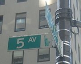
, in addition to having numbered streets, also has streets identified as a letter followed by "Street," going as high as the letter W. New York City
(mostly in Brooklyn
) has avenues titled "Avenue" followed by the respective letter of the alphabet, such as Avenue D. The idea for such a system was developed by Pierre Charles L’Enfant, who devised the system for Washington.
The numbered street system is criticized for taking away the individuality from a community that a named street would provide.
in 1683 and was the first city to use numbered streets systematically. While the original plan had two sets of north-south numbered streets, one parallel to the Delaware River
and one to the Schuylkill
, all are now numbered from the Delaware, with numbers increasing westward. First Street has been known as Front Street, and Fourteenth Street as Broad Street, since the founding of the city. The highest numbered street is 90th Street. In Southwest Philadelphia
, the grid is oblique, with numbered streets running from northwest to southeast. The numerical sequence is consistent with the numbering in adjacent West Philadelphia, and still increases from east to west. Because of the twist, however, the sequence is not consistent with the numbering in South Philadelphia
, across the Schuylkill River
.
The Kensington area has streets lettered "A" through "O". The East Oak Lane and West Oak Lane sections of the city contains east-west streets numbered from 64th Avenue to 80th Avenue, with the numbers correspondent with the block numbers north from Market Street
.
In the early 20th century, many of Chestnut Hill
's previously numbered streets were renamed for Native American
tribes.
 The Commissioners' Plan of 1811
laid out the grid that covers most of Manhattan
today. Most west-east streets (which actually run northwest-southeast) are named "___th Street", and a few major north-south streets (which actually run northeast-southwest, roughly parallel to the island's long axis) are named "___th Avenue".
The highest-numbered street on Manhattan Island is 220th Street, and the highest-numbered street in the Borough of Manhattan is 228th Street, though numbered streets go higher in Queens
and the Bronx, where numbered avenues and other road types also exist. In Brooklyn
, there are ten sets of numbered streets (unprefixed numbered streets as well as North, South, East, West, Bay, Brighton, Paerdegat, Plumb, and Flatlands numbered streets), along with numbered avenues up to 28th Avenue and letter avenues up to Avenue Z. Manhattan's Alphabet City
consists of Avenues A
through D
. The Rockaways
section of Queens has streets prefixed with the word Beach. However, street signs in this area typically identify this prefix using only the letter B (e.g. "B 116 St"). The neighborhood of Broad Channel
also has its own network of numbered roads, prefixed with East or West, relative to Cross Bay Boulevard
.
The closest cross street to a given building number in Manhattan can be estimated using the Manhattan address algorithm
.
The highest-numbered street in all of the New York area is 271st Street, located in New Hyde Park
. The highest-numbered Avenue in Manhattan is the very obscure 13th Avenue
, on Gansevoort Peninsula in the Hudson River just north of Gansevoort Street. Currently, only one unmarked block remains, currently used as a garbage truck access behind the Bloomfield Street Sanitation Depot. The street was once longer, but much of the land it was built on was removed to provide longer piers for berthing larger ships, such as the RMS Lusitania
and RMS Titanic, without protruding further into the Hudson River. 12th Avenue
is the highest numbered avenue that is signed by the city and accessible to the public. Higher-numbered avenues exist in other boroughs.
 Pierre L'Enfant's plan for Washington, D.C.
includes both radial avenues and grid system consisting of both numbered and lettered streets. North-south streets are named with numbers, such as "7th Street
," and west-east streets are named with letters, such as "H Street
." The name is then followed with a directional suffix (NW, NE, SW, or SE), specifying a quadrant of the city (e.g. 16th Street Northwest
. The quadrants meet at the U.S. Capitol building.
Within the city, the quadrants are divided by three streets known as North
, East
, and South
Capitol Streets, and by the National Mall
, which takes the place of the non-existent West Capitol Street. Numbers start counting upward on either side of North and South Capitol Streets, and letters start counting upward on either side of East Capitol Street and the National Mall.
 The city of Baltimore, Maryland, has numbered streets in the north-central part of the city. The numbered streets in Baltimore do not begin with 1, but rather start with 20th Street just north of and parallel to North Avenue, the former northern boundary of the city, and what is viewed by many today is the northern boundary of Downtown Baltimore
. The numbered streets, which go as high as 43rd Street, correspond with the first two digits in the addresses of the north-south streets they cross. Unlike in Washington, where the numbered streets run north-south, Baltimore's numbered streets run west-east. All begin their names with either "West" or "East," depending on which side of Charles Street
the block is located.
Some of Baltimore's numbered streets are well-known for various reasons. 28th and 29th streets, a one-way pair
, are the only numbered streets to have an interchange with I-83. They use the numbered designations to the east of the expressway, and to the west, they merge into a six-lane road known as Druid Park Lake Drive. East 33rd Street was the location of the now-demolished Memorial Stadium
, home to the Baltimore Orioles
for 38 years and the Baltimore Colts
for 31. West 34th Street is the location of the annual Miracle on 34th Street
, where residents on one block of the street open their porches to tourists to view their holiday decorations. West 40th Street is the location of The Rotunda
shopping mall, and it merges into West 41st Street, which crosses over (but does not have an interchange with) I-83 into Television Hill and is the only numbered street in the city west of I-83.
is set on a grid with eight "standard" city blocks per mile. Some blocks are further divided in half. A standard block has 100 address numbers, meaning there are 800 numbers per mile. Chicago address numbering begins downtown at State Street
and Madison Street
; State Street is 0 east and west, and Madison Street is 0 north and south. Major streets a mile apart have address numbers that, for the most part, are multiples of 800.
The south side of the city uses numbered east-west streets, although older streets that were already named retained their names, particularly in the Loop
. The lowest numbered street is 8th street, which is (per the grid) approximately one mile south of Madison, followed by 9th street then Taylor (which was retained instead of 10th St), etc. In some cases, particular blocks or regions of numbered streets retain the older name (Fillmore St for 11th St and Pershing for 39th St. for instance).
The numbering within Chicago is continued throughout many suburbs south of the city proper. For instance, Chicago Heights
has a 185th Street, set on the same numbering schema.
Chicago's numbered street system was adopted in 1911 as a result of new legislation. Madison Street was made the base for all street numbering, and State Street for north-south streets.
run—generally—north-south, while streets that run parallel to the lake shore (generally east-west) have names rather than numbers. Ontario Street in downtown Cleveland separates east- and west-numbered streets, with the numbers increasing as one travels further away from Ontario. Conforming east-west roads are given a name, rather than a number, and the suffix "Avenue." Where an avenue crosses Ontario street or the Cuyahoga River
, its name changes, meaning that a numbered street does not intersect a given avenue more than once. For example, stating a location as "65th and Detroit" implies West 65th street, since Detroit Avenue changes to Superior Avenue when it crosses the river. Non-conforming streets are suffixed with names other than "street" or "avenue," e.g., West Boulevard, Old River Road, Martin Luther King Jr. Drive. Geographic idiosyncrasies in certain parts of the city mean that this is by no means an absolute rule, but generally applies 95% of the time when within the city proper.
.
In the Miami suburbs, some numbered streets and avenues are paired with a parallel "Court", "Drive", "Place" or "Terrace"; while in the same area, other sets of numbered streets and avenues exist with lower numbers. This is known to lead to confusion among some, especially non-locals.
, "___ Mile Road" runs east-west, a stated number of miles from the center of Detroit. Some of these roads are also known by other names. The lowest numbered road is 5 Mile Road The highest such numbered road is 38 Mile Road, which is located mostly in Almont
.
The city of Detroit also has some conventional numbered streets within the city limits.
These are the only numbered streets in San Francisco whose signs include the "St." or "Ave." designation.
The second system is a typical East/West layout, with directional indicators. First Avenue is adjacent to Ellsworth Avenue in Central Denver; the series extends to 168th Avenue in unincorporated Adams County
. Exceptions include Colfax Avenue
, which takes the place of 15th Avenue, and Martin Luther King Jr. Boulevard, which generally takes the place of East 32nd Avenue. The designations East and North are generally not used unless needed. Building numbers on cross-streets reflect the street numbering; for example, 1800 Colorado Boulevard would be at the corner of 18th Avenue. (1800 South Colorado Boulevard is outside the area of numbered streets.)
uses a quadrant system with a grid set. The east-west demarcation line separating the north and south is the Bow River
west of Nose Creek, Centre Avenue directly east of Nose Creek, and Memorial Drive east of 36th Street. The north-south line is Centre Street. Streets run north-south and avenues run east-west; both are numbered beginning at the demarcation lines. Many older areas also have "A" and "B" streets interspersed between the numbered streets; for instance, in most older neighbourhoods the street directly west of Centre Street is 1st Street, but a Centre A Street runs for short distances in certain areas. Suburban neighbourhoods built since approximately 1971 tend to have named streets except in cases where numbered streets extend into the district. A typical (if fictional) street address in an older district would be "4214-19A Street SW". As such, addresses of buildings on numbered streets are worthless without a quadrant.
The grid is based on the Dominion Land Survey
, with many of the main roads in the older areas of town (such as Crowchild Trail SW and 17th Avenue SE) following the lines that separate one DLS section from another ("section lines").
Streets and avenues directly outside the city are sometimes numbered as they would be if they were in the city. The impetus for this came originally from emergency response groups, such as fire departments and police.
's grid system is similar to that of Calgary's except that the two roads designated the "centre" of Edmonton were numbered 100th Avenue and 100th Street. This was done to eliminate any possibility that the city would have quadrants as Calgary does. The expansion of the city has however made this possibility a reality; the city now extends south and east of what would normally be Centre Street and Centre Avenue. As such, most of the city is officially said to be in the northwest quadrant, but common use is to not use the quadrant unless the address is both on a numbered street and not in the northwest.
, in the municipalities of Delta
, Surrey
and Langley. Avenues run east-west and are numbered starting with 0 ("Zero") avenue next to the Canada-U.S. Border and going north, with the numbers incrementing each mile (200 metres). Streets run north-south and are numbered starting with zero lying in the Strait of Georgia
and going east, with the numbers incrementing each mile, just like the avenues. Minor streets named with a number followed by a letter (136A Street, 136B street) are situated between the numbers.
The city of Vancouver
proper uses its own road numbering system, numbering east-west avenues from first at False Creek
and incrementing south.
, where streets, running north-south, are numbered; and Red Deer, Alberta
, where numbered streets run east-west, and numbered avenues run north-south. In Saskatoon, Saskatchewan only the streets, running east-west, are numbered (aside from avenues downtown, which are numbered from 1st to 10th); there are lettered avenues to the west of Idylwyld Drive, which was formerly known as Avenue A (a stub of Avenue A does remain south of 20th Street though). Streets in the Sutherland district in Saskatoon are numbered 101 St to 117 St. This was done when the town of Sutherland amalgamated with Saskatoon, to avoid confusion with Saskatoon's numbered streets, which run from 1 to 71. Owen Sound, Ontario
, in Eastern Canada, also has numbered streets and avenues.
Numerous street numbering schemes were proposed for the various municipalities originally making up Greater Winnipeg
, but most were quickly rescinded, as the city is not built on a grid and numbering was considered unwieldy. Only one roadway (Fifth Avenue in St. Vital) retains its "number", but the street name is legally the word "Fifth" and not the number. Numbered roadways are also found within CFB Winnipeg
, but the street names within the base were chosen by the Department of National Defence and not by the city itself.
where blocks are numbered in a grid-like system since 1811, and streets actually don't have names anymore - for example the houses in "street" B7 are those in the block in grid B7. The houses on the other side of the street belong to other blocks and therefore have another street name.
are multiple sets of numbered streets running from west to east in various sections of the north side of town. In many such sections, the street numbers count upward by two, with even-numbered streets on one side of a neighborhood, and odd-numbered streets on the other. The highest numbered street is 304th Street. The city also has other series of streets with a name combining with a number.
, most streets and roads are numbered. Most commonly in smaller cities, they are identified with a 4-digit number followed by "way."
has even-numbered streets running west-east, and odd-numbered streets running north-south.
has numbered streets that simply have the number followed by "street" (e.g. 41st Street), as well as streets named with a number followed by a letter (23 B Street).
has even-numbered streets running north-south, and odd-numbered streets running east-west on the west side of the city, with lettered streets from A through P running north-south beginning on the east side of Paseo Ave. Some streets are named with a number followed by a letter (23 B Street).
Ordinal number
In set theory, an ordinal number, or just ordinal, is the order type of a well-ordered set. They are usually identified with hereditarily transitive sets. Ordinals are an extension of the natural numbers different from integers and from cardinals...
, as in Second Street or Tenth Avenue. Such forms are among the most common street names in North America
North America
North America is a continent wholly within the Northern Hemisphere and almost wholly within the Western Hemisphere. It is also considered a northern subcontinent of the Americas...
, but also exist in other parts of the world, especially in the Middle East
Middle East
The Middle East is a region that encompasses Western Asia and Northern Africa. It is often used as a synonym for Near East, in opposition to Far East...
. Numbered streets were first used in Philadelphia and now exist in many major cities and small towns. Grid-based naming systems usually start at 1 (but sometimes at a higher number), and then proceed in numerical order. In the United States, seven out of the top ten most common street names are numbers, with the top three names being "2nd," "3rd," and "1st" respectively.
Some cities also have lettered street names. For example, Washington, D.C.
Washington, D.C.
Washington, D.C., formally the District of Columbia and commonly referred to as Washington, "the District", or simply D.C., is the capital of the United States. On July 16, 1790, the United States Congress approved the creation of a permanent national capital as permitted by the U.S. Constitution....
, in addition to having numbered streets, also has streets identified as a letter followed by "Street," going as high as the letter W. New York City
New York City
New York is the most populous city in the United States and the center of the New York Metropolitan Area, one of the most populous metropolitan areas in the world. New York exerts a significant impact upon global commerce, finance, media, art, fashion, research, technology, education, and...
(mostly in Brooklyn
Brooklyn
Brooklyn is the most populous of New York City's five boroughs, with nearly 2.6 million residents, and the second-largest in area. Since 1896, Brooklyn has had the same boundaries as Kings County, which is now the most populous county in New York State and the second-most densely populated...
) has avenues titled "Avenue" followed by the respective letter of the alphabet, such as Avenue D. The idea for such a system was developed by Pierre Charles L’Enfant, who devised the system for Washington.
The numbered street system is criticized for taking away the individuality from a community that a named street would provide.
Philadelphia
Central Philadelphia was laid out by Thomas HolmeThomas Holme
Thomas Holme was the first Surveyor General of Pennsylvania to actually serve, in which capacity he laid out the original plan for the city of Philadelphia.-Life:...
in 1683 and was the first city to use numbered streets systematically. While the original plan had two sets of north-south numbered streets, one parallel to the Delaware River
Delaware River
The Delaware River is a major river on the Atlantic coast of the United States.A Dutch expedition led by Henry Hudson in 1609 first mapped the river. The river was christened the South River in the New Netherland colony that followed, in contrast to the North River, as the Hudson River was then...
and one to the Schuylkill
Schuylkill River
The Schuylkill River is a river in Pennsylvania. It is a designated Pennsylvania Scenic River.The river is about long. Its watershed of about lies entirely within the state of Pennsylvania. The source of its eastern branch is in the Appalachian Mountains at Tuscarora Springs, near Tamaqua in...
, all are now numbered from the Delaware, with numbers increasing westward. First Street has been known as Front Street, and Fourteenth Street as Broad Street, since the founding of the city. The highest numbered street is 90th Street. In Southwest Philadelphia
Southwest Philadelphia
Southwest Philadelphia is a section of Philadelphia, Pennsylvania, United States. The section can be described as extending from the western side of the Schuylkill River to the city line, with the SEPTA Media/Elwyn Line serving as the northern border...
, the grid is oblique, with numbered streets running from northwest to southeast. The numerical sequence is consistent with the numbering in adjacent West Philadelphia, and still increases from east to west. Because of the twist, however, the sequence is not consistent with the numbering in South Philadelphia
South Philadelphia
South Philadelphia, nicknamed South Philly, is the section of Philadelphia bounded by South Street to the north, the Delaware River to the east and south, and the Schuylkill River to the west.-History:...
, across the Schuylkill River
Schuylkill River
The Schuylkill River is a river in Pennsylvania. It is a designated Pennsylvania Scenic River.The river is about long. Its watershed of about lies entirely within the state of Pennsylvania. The source of its eastern branch is in the Appalachian Mountains at Tuscarora Springs, near Tamaqua in...
.
The Kensington area has streets lettered "A" through "O". The East Oak Lane and West Oak Lane sections of the city contains east-west streets numbered from 64th Avenue to 80th Avenue, with the numbers correspondent with the block numbers north from Market Street
Market Street (Philadelphia)
Market Street, originally known as High Street, is a major east–west street in Philadelphia, Pennsylvania. For the majority of its length, it serves as Pennsylvania Route 3....
.
In the early 20th century, many of Chestnut Hill
Chestnut Hill, Philadelphia, Pennsylvania
Chestnut Hill is a neighborhood in the Northwest Philadelphia section of the United States city of Philadelphia, Pennsylvania.-Boundaries:Chestnut Hill is bounded as follows:...
's previously numbered streets were renamed for Native American
Indigenous peoples of the Americas
The indigenous peoples of the Americas are the pre-Columbian inhabitants of North and South America, their descendants and other ethnic groups who are identified with those peoples. Indigenous peoples are known in Canada as Aboriginal peoples, and in the United States as Native Americans...
tribes.
New York City
Commissioners' Plan of 1811
The Commissioners' Plan of 1811 was the original design plan for the streets of Manhattan, which put in place the grid plan that has defined Manhattan to this day....
laid out the grid that covers most of Manhattan
Manhattan
Manhattan is the oldest and the most densely populated of the five boroughs of New York City. Located primarily on the island of Manhattan at the mouth of the Hudson River, the boundaries of the borough are identical to those of New York County, an original county of the state of New York...
today. Most west-east streets (which actually run northwest-southeast) are named "___th Street", and a few major north-south streets (which actually run northeast-southwest, roughly parallel to the island's long axis) are named "___th Avenue".
The highest-numbered street on Manhattan Island is 220th Street, and the highest-numbered street in the Borough of Manhattan is 228th Street, though numbered streets go higher in Queens
Queens
Queens is the easternmost of the five boroughs of New York City. The largest borough in area and the second-largest in population, it is coextensive with Queens County, an administrative division of New York state, in the United States....
and the Bronx, where numbered avenues and other road types also exist. In Brooklyn
Brooklyn
Brooklyn is the most populous of New York City's five boroughs, with nearly 2.6 million residents, and the second-largest in area. Since 1896, Brooklyn has had the same boundaries as Kings County, which is now the most populous county in New York State and the second-most densely populated...
, there are ten sets of numbered streets (unprefixed numbered streets as well as North, South, East, West, Bay, Brighton, Paerdegat, Plumb, and Flatlands numbered streets), along with numbered avenues up to 28th Avenue and letter avenues up to Avenue Z. Manhattan's Alphabet City
Alphabet City, Manhattan
Alphabet City is a neighborhood located within the Lower East Side and East Village in the New York City borough of Manhattan. It is also known as Loisaida, a Spanglish adaptation of 'Lower East Side'. Its name comes from Avenues A, B, C, and D, the only avenues in Manhattan to have single-letter...
consists of Avenues A
Avenue A (Manhattan)
Avenue A runs from north to south and is the westernmost of the avenues to be defined by letters instead of using the numbering system in the New York City borough of Manhattan. Avenue A runs from Houston Street to 14th Street, where it continues into a loop road in Stuyvesant Town, connecting to...
through D
Avenue D (Manhattan)
Avenue D is the easternmost named avenue in the East Village neighborhood in the New York City borough of Manhattan, though several thoroughfares are closer to the East River. This area is also known as Alphabet City. Avenue D runs between East 12th Street and Houston Street, and continues south...
. The Rockaways
Rockaway, Queens
The Rockaway Peninsula, informally The Rockaways, is the name of a peninsula of Long Island, all of which is located within the New York City borough of Queens. A popular summer resort area since the 1830s, Rockaway has become a mixture of lower, middle, and upper-class neighborhoods...
section of Queens has streets prefixed with the word Beach. However, street signs in this area typically identify this prefix using only the letter B (e.g. "B 116 St"). The neighborhood of Broad Channel
Broad Channel, Queens
Broad Channel is a neighborhood in the New York City borough of Queens. It occupies the southern portion of Rulers Bar Hassock , which is the only inhabited island in Jamaica Bay. The neighborhood stands on Big Egg Marsh, an area of fill approximately 20 blocks long and 4 blocks wide...
also has its own network of numbered roads, prefixed with East or West, relative to Cross Bay Boulevard
Cross Bay Boulevard
Cross Bay Boulevard is the main north–south road in Howard Beach, a neighborhood in the New York City borough of Queens. In the south, it originates in The Rockaways, runs over the Cross Bay Bridge into Broad Channel and then over the Joseph P. Addabbo Memorial Bridge into Howard Beach...
.
The closest cross street to a given building number in Manhattan can be estimated using the Manhattan address algorithm
Manhattan address algorithm
The Manhattan address algorithm is used to estimate the number of the closest cross street for a given building number on the island of Manhattan...
.
The highest-numbered street in all of the New York area is 271st Street, located in New Hyde Park
New Hyde Park, New York
New Hyde Park is a village in Nassau County, New York, United States, on Long Island.The population of the Village of New Hyde Park was 9,712 at the 2010 census...
. The highest-numbered Avenue in Manhattan is the very obscure 13th Avenue
13th Avenue (Manhattan)
Thirteenth Avenue is a street in the New York City borough of Manhattan, USA, built on landfill in 1837 along the Hudson River, though only a block of it still remains....
, on Gansevoort Peninsula in the Hudson River just north of Gansevoort Street. Currently, only one unmarked block remains, currently used as a garbage truck access behind the Bloomfield Street Sanitation Depot. The street was once longer, but much of the land it was built on was removed to provide longer piers for berthing larger ships, such as the RMS Lusitania
RMS Lusitania
RMS Lusitania was a British ocean liner designed by Leonard Peskett and built by John Brown and Company of Clydebank, Scotland. The ship entered passenger service with the Cunard Line on 26 August 1907 and continued on the line's heavily-traveled passenger service between Liverpool, England and New...
and RMS Titanic, without protruding further into the Hudson River. 12th Avenue
West Side Highway
The West Side Highway is a mostly surface section of New York State Route 9A that runs from West 72nd Street along the Hudson River to the southern tip of Manhattan. It replaced the West Side Elevated Highway, built between 1929 and 1951, which was shut down in 1973 due to neglect and lack of...
is the highest numbered avenue that is signed by the city and accessible to the public. Higher-numbered avenues exist in other boroughs.
Washington, D.C.
Washington, D.C.
Washington, D.C., formally the District of Columbia and commonly referred to as Washington, "the District", or simply D.C., is the capital of the United States. On July 16, 1790, the United States Congress approved the creation of a permanent national capital as permitted by the U.S. Constitution....
includes both radial avenues and grid system consisting of both numbered and lettered streets. North-south streets are named with numbers, such as "7th Street
7th Street (Washington, D.C.)
There are four north-south arteries in Washington, D.C. named Seventh Street that are differentiated by the quadrants of the city in which they are located. Historically, 7th Street has been a main north-south road in Washington, being the main route for travelers and farmers coming into the city...
," and west-east streets are named with letters, such as "H Street
H Street (Washington, D.C.)
H Street is an east-west street in Washington, D.C.. It is also used as an alternate name for the Near Northeast neighborhood, as H Street is the neighborhood's main commercial strip.-History:...
." The name is then followed with a directional suffix (NW, NE, SW, or SE), specifying a quadrant of the city (e.g. 16th Street Northwest
16th Street Northwest (Washington, D.C.)
16th Street Northwest is a prominent north-south thoroughfare in the northwest quadrant of Washington, D.C.Part of Pierre L'Enfant's design for the city, 16th Street begins just north of the White House across Lafayette Park at H Street and continues due north in a straight line passing K Street,...
. The quadrants meet at the U.S. Capitol building.
Within the city, the quadrants are divided by three streets known as North
North Capitol Street
North Capitol Street is a street in Washington, D.C. that separates the Northwest and Northeast quadrants of the city. The street begins at D Street due north of the United States Capitol and continues northward 4½ miles to Nicholson Street where it is interrupted by Fort Slocum Park and the...
, East
East Capitol Street
East Capitol Street is a major street that divides the northeast and southeast quadrants of Washington, D.C. It runs due east from the United States Capitol to the DC-Maryland border. The street is uninterrupted until Lincoln Park then continues eastward to Robert F. Kennedy Memorial Stadium...
, and South
South Capitol Street
South Capitol Street is a major street dividing the southeast and southwest quadrants of Washington, D.C. It runs south from the United States Capitol to the Washington-Maryland line...
Capitol Streets, and by the National Mall
National Mall
The National Mall is an open-area national park in downtown Washington, D.C., the capital of the United States. The National Mall is a unit of the National Park Service , and is administered by the National Mall and Memorial Parks unit...
, which takes the place of the non-existent West Capitol Street. Numbers start counting upward on either side of North and South Capitol Streets, and letters start counting upward on either side of East Capitol Street and the National Mall.
Baltimore
Downtown Baltimore
Downtown Baltimore is the section of Baltimore traditionally bounded by Martin Luther King, Jr. Boulevard to the west, Mt. Royal Avenue to the north, President Street to the east and the Inner Harbor area to the south. It consists of four neighborhoods: Westside, City Centre, Inner Harbor, and...
. The numbered streets, which go as high as 43rd Street, correspond with the first two digits in the addresses of the north-south streets they cross. Unlike in Washington, where the numbered streets run north-south, Baltimore's numbered streets run west-east. All begin their names with either "West" or "East," depending on which side of Charles Street
Maryland Route 139
Maryland Route 139, known locally for most of its existence as North Charles Street, runs through Baltimore City and through the Towson area of Baltimore County. On the north end it terminates at a traffic circle with Bellona Avenue near Interstate 695 and at the south end it terminates in Federal...
the block is located.
Some of Baltimore's numbered streets are well-known for various reasons. 28th and 29th streets, a one-way pair
One-way pair
A one-way pair, one-way couple, or just couplet is a pair of parallel, usually one-way streets that carry opposite directions of a signed route or major traffic flow, or sometimes opposite directions of a bus or streetcar route....
, are the only numbered streets to have an interchange with I-83. They use the numbered designations to the east of the expressway, and to the west, they merge into a six-lane road known as Druid Park Lake Drive. East 33rd Street was the location of the now-demolished Memorial Stadium
Memorial Stadium (Baltimore)
Memorial Stadium was a sports stadium in Baltimore, Maryland, that formerly stood on 33rd Street on an over-sized block also bounded by Ellerslie Avenue , 36th Street , and Ednor Road...
, home to the Baltimore Orioles
Baltimore Orioles
The Baltimore Orioles are a professional baseball team based in Baltimore, Maryland in the United States. They are a member of the Eastern Division of Major League Baseball's American League. One of the American League's eight charter franchises in 1901, it spent its first year as a major league...
for 38 years and the Baltimore Colts
History of the Indianapolis Colts
The Indianapolis Colts are a professional football team based in Indianapolis, Indiana. They play in the AFC South division of the National Football League. They have won 3 NFL championships and 2 Super Bowls....
for 31. West 34th Street is the location of the annual Miracle on 34th Street
Miracle on 34th Street (Baltimore)
In Baltimore, Maryland, Miracle on 34th Street is a display of holiday lights that takes place annually on the 700 block of 34th Street in Baltimore's Hampden community...
, where residents on one block of the street open their porches to tourists to view their holiday decorations. West 40th Street is the location of The Rotunda
The Rotunda (Baltimore)
The Rotunda is a shopping mall in Baltimore, Maryland, located near the renowned neighborhoods of Roland Park, Hampden, and Charles Village, and near Johns Hopkins University. The mall was developed by Bernard Manekin who converted the 1920's Maryland Casualty Insurance Co. building, designed by...
shopping mall, and it merges into West 41st Street, which crosses over (but does not have an interchange with) I-83 into Television Hill and is the only numbered street in the city west of I-83.
Chicago
The City of ChicagoChicago
Chicago is the largest city in the US state of Illinois. With nearly 2.7 million residents, it is the most populous city in the Midwestern United States and the third most populous in the US, after New York City and Los Angeles...
is set on a grid with eight "standard" city blocks per mile. Some blocks are further divided in half. A standard block has 100 address numbers, meaning there are 800 numbers per mile. Chicago address numbering begins downtown at State Street
State Street (Chicago)
State Street is a large south-north street in Chicago, Illinois, USA and its south suburbs. It begins on the Near North Side at North Avenue. For much of its course, it lies between Wabash Avenue on the east and Dearborn Street/Lafayette Avenue on the west...
and Madison Street
Madison Street (Chicago)
Madison Street is a major east-west street in Chicago, Illinois. Prior to human intervention, the Chicago River emptied into Lake Michigan at the present day intersection of Madison Street and Michigan Avenue....
; State Street is 0 east and west, and Madison Street is 0 north and south. Major streets a mile apart have address numbers that, for the most part, are multiples of 800.
The south side of the city uses numbered east-west streets, although older streets that were already named retained their names, particularly in the Loop
Chicago Loop
The Loop or Chicago Loop is one of 77 officially designated Chicago community areas located in the City of Chicago, Illinois. It is the historic commercial center of downtown Chicago...
. The lowest numbered street is 8th street, which is (per the grid) approximately one mile south of Madison, followed by 9th street then Taylor (which was retained instead of 10th St), etc. In some cases, particular blocks or regions of numbered streets retain the older name (Fillmore St for 11th St and Pershing for 39th St. for instance).
The numbering within Chicago is continued throughout many suburbs south of the city proper. For instance, Chicago Heights
Chicago Heights, Illinois
Chicago Heights is a city in Cook County, Illinois, United States. The population was 31,373 at the 2005 census. Chicago Heights is nicknamed 'Crossroads of the Nation'.-History:...
has a 185th Street, set on the same numbering schema.
Chicago's numbered street system was adopted in 1911 as a result of new legislation. Madison Street was made the base for all street numbering, and State Street for north-south streets.
Cleveland
As a general rule, the only numbered streets in ClevelandCleveland, Ohio
Cleveland is a city in the U.S. state of Ohio and is the county seat of Cuyahoga County, the most populous county in the state. The city is located in northeastern Ohio on the southern shore of Lake Erie, approximately west of the Pennsylvania border...
run—generally—north-south, while streets that run parallel to the lake shore (generally east-west) have names rather than numbers. Ontario Street in downtown Cleveland separates east- and west-numbered streets, with the numbers increasing as one travels further away from Ontario. Conforming east-west roads are given a name, rather than a number, and the suffix "Avenue." Where an avenue crosses Ontario street or the Cuyahoga River
Cuyahoga River
The Cuyahoga River is located in Northeast Ohio in the United States. Outside of Ohio, the river is most famous for being "the river that caught fire", helping to spur the environmental movement in the late 1960s...
, its name changes, meaning that a numbered street does not intersect a given avenue more than once. For example, stating a location as "65th and Detroit" implies West 65th street, since Detroit Avenue changes to Superior Avenue when it crosses the river. Non-conforming streets are suffixed with names other than "street" or "avenue," e.g., West Boulevard, Old River Road, Martin Luther King Jr. Drive. Geographic idiosyncrasies in certain parts of the city mean that this is by no means an absolute rule, but generally applies 95% of the time when within the city proper.
Miami
In Greater Miami, numbered streets go into three digits, with varying, overlapping sets of numbered streets. The area has roads that are named as a number followed by "Street" that run west-east, and a number followed by "Avenue" that run north-south. All these streets start their names with NW, NE, SW, or SE, depending where they are in relation to the center of MiamiMiami, Florida
Miami is a city located on the Atlantic coast in southeastern Florida and the county seat of Miami-Dade County, the most populous county in Florida and the eighth-most populous county in the United States with a population of 2,500,625...
.
In the Miami suburbs, some numbered streets and avenues are paired with a parallel "Court", "Drive", "Place" or "Terrace"; while in the same area, other sets of numbered streets and avenues exist with lower numbers. This is known to lead to confusion among some, especially non-locals.
Detroit
In the northern suburbs of DetroitMetro Detroit
The Detroit metropolitan area, often referred to as Metro Detroit, is the metropolitan area located in Southeast Michigan centered on the city of Detroit which shares an international border with Windsor, Ontario. The Detroit metropolitan area is the second largest U.S. metropolitan area...
, "___ Mile Road" runs east-west, a stated number of miles from the center of Detroit. Some of these roads are also known by other names. The lowest numbered road is 5 Mile Road The highest such numbered road is 38 Mile Road, which is located mostly in Almont
Almont, Michigan
Almont is a village in Lapeer County in the U.S. state of Michigan. The population was 2,803 at the 2000 census. The village is located within Almont Township....
.
The city of Detroit also has some conventional numbered streets within the city limits.
San Francisco
San Francisco has two numbered series: First Street through 30th Street in South-of-Market and the Mission district, and Second Avenue through 48th Avenue in the Richmond and Sunset districts, with 48th nearest the Pacific Ocean. (The street that would be First Avenue is named Arguello Boulevard, and Funston Avenue replaces Thirteenth Avenue, although Thirteenth Street exists.) Unlike Manhattan, the numbered Streets and Avenues do not meet; but, because of a bend in the pattern, Third Street meets 16th through 26th Streets.These are the only numbered streets in San Francisco whose signs include the "St." or "Ave." designation.
Denver
Denver has two systems in place in two distinct areas of the city. Downtown Denver's diagonal street system technically begins with 4th Street near Auraria Campus, underneath the Colfax Avenue viaduct. The system then counts up northeastward from 4th Street to 40th Street. The diagonal system meets the normal numbered grid at various points, with the termination of the downtown system at 40th Avenue and 40th Street in the Five Points neighborhood.The second system is a typical East/West layout, with directional indicators. First Avenue is adjacent to Ellsworth Avenue in Central Denver; the series extends to 168th Avenue in unincorporated Adams County
Adams County, Colorado
Adams County is the fifth most populous of the 64 counties of the state of Colorado of the United States. The United States Census Bureau estimates that the county population was 441,603 in 2010 census, a 21.4% increase since 2000 census. Adams County is named for Alva Adams, Governor of the...
. Exceptions include Colfax Avenue
Colfax Avenue
Colfax Avenue is the main street that runs east–west through the Denver-Aurora metropolitan area in Colorado. As U.S. Highway 40, it was one of two principal highways serving Denver before the Interstate Highway System was constructed. In the local street system, it lies 15 blocks north of the zero...
, which takes the place of 15th Avenue, and Martin Luther King Jr. Boulevard, which generally takes the place of East 32nd Avenue. The designations East and North are generally not used unless needed. Building numbers on cross-streets reflect the street numbering; for example, 1800 Colorado Boulevard would be at the corner of 18th Avenue. (1800 South Colorado Boulevard is outside the area of numbered streets.)
Calgary
The city of CalgaryCalgary
Calgary is a city in the Province of Alberta, Canada. It is located in the south of the province, in an area of foothills and prairie, approximately east of the front ranges of the Canadian Rockies...
uses a quadrant system with a grid set. The east-west demarcation line separating the north and south is the Bow River
Bow River
The Bow River is a river in the Canadian province of Alberta. It is a tributary of the South Saskatchewan River, and is considered the headwater of the Nelson River....
west of Nose Creek, Centre Avenue directly east of Nose Creek, and Memorial Drive east of 36th Street. The north-south line is Centre Street. Streets run north-south and avenues run east-west; both are numbered beginning at the demarcation lines. Many older areas also have "A" and "B" streets interspersed between the numbered streets; for instance, in most older neighbourhoods the street directly west of Centre Street is 1st Street, but a Centre A Street runs for short distances in certain areas. Suburban neighbourhoods built since approximately 1971 tend to have named streets except in cases where numbered streets extend into the district. A typical (if fictional) street address in an older district would be "4214-19A Street SW". As such, addresses of buildings on numbered streets are worthless without a quadrant.
The grid is based on the Dominion Land Survey
Dominion Land Survey
The Dominion Land Survey is the method used to divide most of Western Canada into one-square-mile sections for agricultural and other purposes. It is based on the layout of the Public Land Survey System used in the United States, but has several differences...
, with many of the main roads in the older areas of town (such as Crowchild Trail SW and 17th Avenue SE) following the lines that separate one DLS section from another ("section lines").
Streets and avenues directly outside the city are sometimes numbered as they would be if they were in the city. The impetus for this came originally from emergency response groups, such as fire departments and police.
Edmonton
The city of EdmontonEdmonton
Edmonton is the capital of the Canadian province of Alberta and is the province's second-largest city. Edmonton is located on the North Saskatchewan River and is the centre of the Edmonton Capital Region, which is surrounded by the central region of the province.The city and its census...
's grid system is similar to that of Calgary's except that the two roads designated the "centre" of Edmonton were numbered 100th Avenue and 100th Street. This was done to eliminate any possibility that the city would have quadrants as Calgary does. The expansion of the city has however made this possibility a reality; the city now extends south and east of what would normally be Centre Street and Centre Avenue. As such, most of the city is officially said to be in the northwest quadrant, but common use is to not use the quadrant unless the address is both on a numbered street and not in the northwest.
Metro Vancouver
A grid system of numbered streets and avenues is used south of the Fraser RiverFraser River
The Fraser River is the longest river within British Columbia, Canada, rising at Fraser Pass near Mount Robson in the Rocky Mountains and flowing for , into the Strait of Georgia at the city of Vancouver. It is the tenth longest river in Canada...
, in the municipalities of Delta
Delta, British Columbia
Delta is a district municipality in British Columbia, and forms part of Metro Vancouver. Located south of Richmond, it is bordered by the Fraser River to the north, the United States to the south and the city of Surrey to the east...
, Surrey
Surrey, British Columbia
Surrey is a city in the province of British Columbia, Canada. It is a member municipality of Metro Vancouver, the governing body of the Greater Vancouver Regional District...
and Langley. Avenues run east-west and are numbered starting with 0 ("Zero") avenue next to the Canada-U.S. Border and going north, with the numbers incrementing each mile (200 metres). Streets run north-south and are numbered starting with zero lying in the Strait of Georgia
Strait of Georgia
The Strait of Georgia or the Georgia Strait is a strait between Vancouver Island and the mainland coast of British Columbia, Canada. It is approximately long and varies in width from...
and going east, with the numbers incrementing each mile, just like the avenues. Minor streets named with a number followed by a letter (136A Street, 136B street) are situated between the numbers.
The city of Vancouver
Vancouver
Vancouver is a coastal seaport city on the mainland of British Columbia, Canada. It is the hub of Greater Vancouver, which, with over 2.3 million residents, is the third most populous metropolitan area in the country,...
proper uses its own road numbering system, numbering east-west avenues from first at False Creek
False Creek
False Creek is a short inlet in the heart of Vancouver. It separates downtown from the rest of the city. It was named by George Henry Richards during his Hydrographic survey of 1856-63. Science World is located at its eastern end and the Burrard Street Bridge crosses its western end. False Creek is...
and incrementing south.
Other Canadian cities and towns
Many small towns and cities in Western Canada use numbered streets. Some begin numbering at Centre as Calgary does, but others follow Edmonton's example and begin numbering at 1, 50, or 100. Examples include Brandon, ManitobaBrandon, Manitoba
Brandon is the second largest city in Manitoba, Canada, and is located in the southwestern area of the province. Brandon is the largest city in the Westman region of Manitoba. The city is located along the Assiniboine River. Spruce Woods Provincial Park and CFB Shilo are a relatively short distance...
, where streets, running north-south, are numbered; and Red Deer, Alberta
Red Deer, Alberta
Red Deer is a city in Central Alberta, Canada. It is located near the midpoint of the Calgary-Edmonton Corridor and is surrounded by Red Deer County. It is Alberta's third-most-populous city – after Calgary and Edmonton. The city is located in aspen parkland, a region of rolling hills...
, where numbered streets run east-west, and numbered avenues run north-south. In Saskatoon, Saskatchewan only the streets, running east-west, are numbered (aside from avenues downtown, which are numbered from 1st to 10th); there are lettered avenues to the west of Idylwyld Drive, which was formerly known as Avenue A (a stub of Avenue A does remain south of 20th Street though). Streets in the Sutherland district in Saskatoon are numbered 101 St to 117 St. This was done when the town of Sutherland amalgamated with Saskatoon, to avoid confusion with Saskatoon's numbered streets, which run from 1 to 71. Owen Sound, Ontario
Owen Sound, Ontario
Owen Sound , the county seat of Grey County, is a city in Southern Ontario, Canada...
, in Eastern Canada, also has numbered streets and avenues.
Numerous street numbering schemes were proposed for the various municipalities originally making up Greater Winnipeg
Winnipeg
Winnipeg is the capital and largest city of Manitoba, Canada, and is the primary municipality of the Winnipeg Capital Region, with more than half of Manitoba's population. It is located near the longitudinal centre of North America, at the confluence of the Red and Assiniboine Rivers .The name...
, but most were quickly rescinded, as the city is not built on a grid and numbering was considered unwieldy. Only one roadway (Fifth Avenue in St. Vital) retains its "number", but the street name is legally the word "Fifth" and not the number. Numbered roadways are also found within CFB Winnipeg
CFB Winnipeg
Canadian Forces Base Winnipeg , is a Canadian Forces Base located within the City of Winnipeg, Manitoba. Co-located at the Winnipeg James Armstrong Richardson International Airport, CFB Winnipeg is home to many flight operations support divisions, as well as several training schools...
, but the street names within the base were chosen by the Department of National Defence and not by the city itself.
Mannheim
A notable European example is the city of MannheimMannheim
Mannheim is a city in southwestern Germany. With about 315,000 inhabitants, Mannheim is the second-largest city in the Bundesland of Baden-Württemberg, following the capital city of Stuttgart....
where blocks are numbered in a grid-like system since 1811, and streets actually don't have names anymore - for example the houses in "street" B7 are those in the block in grid B7. The houses on the other side of the street belong to other blocks and therefore have another street name.
Tehran
In TehranTehran
Tehran , sometimes spelled Teheran, is the capital of Iran and Tehran Province. With an estimated population of 8,429,807; it is also Iran's largest urban area and city, one of the largest cities in Western Asia, and is the world's 19th largest city.In the 20th century, Tehran was subject to...
are multiple sets of numbered streets running from west to east in various sections of the north side of town. In many such sections, the street numbers count upward by two, with even-numbered streets on one side of a neighborhood, and odd-numbered streets on the other. The highest numbered street is 304th Street. The city also has other series of streets with a name combining with a number.
United Arab Emirates
In United Arab EmiratesUnited Arab Emirates
The United Arab Emirates, abbreviated as the UAE, or shortened to "the Emirates", is a state situated in the southeast of the Arabian Peninsula in Western Asia on the Persian Gulf, bordering Oman, and Saudi Arabia, and sharing sea borders with Iraq, Kuwait, Bahrain, Qatar, and Iran.The UAE is a...
, most streets and roads are numbered. Most commonly in smaller cities, they are identified with a 4-digit number followed by "way."
Abu Dhabi
Abu DhabiAbu Dhabi
Abu Dhabi , literally Father of Gazelle, is the capital and the second largest city of the United Arab Emirates in terms of population and the largest of the seven member emirates of the United Arab Emirates. Abu Dhabi lies on a T-shaped island jutting into the Persian Gulf from the central western...
has even-numbered streets running west-east, and odd-numbered streets running north-south.
Dubai
DubaiDubai
Dubai is a city and emirate in the United Arab Emirates . The emirate is located south of the Persian Gulf on the Arabian Peninsula and has the largest population with the second-largest land territory by area of all the emirates, after Abu Dhabi...
has numbered streets that simply have the number followed by "street" (e.g. 41st Street), as well as streets named with a number followed by a letter (23 B Street).
Havana
HavanaHavana
Havana is the capital city, province, major port, and leading commercial centre of Cuba. The city proper has a population of 2.1 million inhabitants, and it spans a total of — making it the largest city in the Caribbean region, and the most populous...
has even-numbered streets running north-south, and odd-numbered streets running east-west on the west side of the city, with lettered streets from A through P running north-south beginning on the east side of Paseo Ave. Some streets are named with a number followed by a letter (23 B Street).