
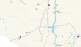
New York State Route 208
Encyclopedia
New York State Route 208 (NY 208) is a state highway
located in southern New York
in the United States
. The southern terminus is at an intersection with NY 17M
in the Orange County
village of Monroe
. Its northern terminus is located at an intersection with NY 32
and NY 299
in the Ulster County
village of New Paltz
.
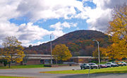
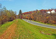
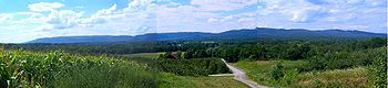
208 is a two-lane road for its entire length. While connecting two bustling villages and passing through three others, it is primarily a country road and offers a variety of scenery and points of interest, from fields and meadows to a riverside stretch and orchard
s devoted to apple
s. The northern third, between Wallkill
and New Paltz, boasts a near-continuous view of the Shawangunk Ridge
.
, Route 208 quickly crosses US 6
and NY 17
and then stays in the shade of the southwestern corner of Schunemunk Mountain
as it heads north to Washingtonville
, remaining relatively straight through mostly wooded, undeveloped country with some views of the mountain. Round Hill Elementary School heralds the approach of the village. Shortly after entering Washingtonville, it intersects with NY 94
.
Again it crosses the village line rather quickly, going through some sharp curves as it enters more open farmland. Here 208 also deviates from its northward course, heading much more westward as it picks up the headwaters of Moodna Creek
and passes its source, the confluence
of Otter Kill
and Cromline Creek. Shortly afterwards, it again turns northward at the Sarah Wells Trail junction. Eventually the land surrounding the highway once again becomes more wooded and it goes through a short tunnel under the railroad tracks
shared by Norfolk Southern and Metro-North
.
A mile or so past the tunnel, 208 abruptly reaches NY 207
outside the hamlet of Rock Tavern. 208 overlaps 207 for a hundred yards as the two roads pass small Brown's Pond and a weir
, then 208 once again turns left to go north alongside the pond, into some more open countryside. It passes the west boundary of Stewart State Forest, goes over a little-used rail spur, once part of the Wallkill Valley Railroad (WVRR) and then enters Maybrook
, which it serves as the main street. A feature of this town is the large Yellow Freight terminal in its north end, continuing a tradition of importance in transportation that began with the village's origins as a major regional rail hub.
 Shortly after leaving Maybrook, 208 reaches I-84
. This exit, the only one for several miles in either direction on the interstate, contains several businesses. Here, for the only point on its entire length, 208 swells beyond two lanes with the addition of turn lanes for the interstate's onramps. There is a heavy truck presence at the Rt. 208 and I-84 interchange. Several companies have built warehouse facilities on Neelytown Road, including Home Depot, Cardinal Health and Do It Best Corporation. Also found in this area is Federal Express Freight, Yellow Freight and several other national trucking firms.
North of I-84, the road remains a two-lane until it intersects with NY 17K
at Scotts Corners. This intersection was redesigned and upgraded in 2008 to accommodate left and right turn lanes.
 Continuing north, 208 goes around some mild bends past woods and fields. Here the highway offers its first view to the Shawangunks. In 2 miles (3.2 km) it reaches Walden
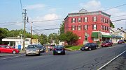
, the largest community on 208 after Monroe. After crossing the old WVRR main line, now the north end of a lightly used freight spur, it becomes Orange Avenue with a mix of residential and commercial properties. In the center of town NY 52
comes in from the east at an oblique angle more like a merger than a junction; traffic at rush hour there is made more difficult by vehicles attempting to cross 52 and enter the adjacent Hess station as well as a local one-way side street. Since 52 comes in at a slightly lower elevation, it has the right of way, guaranteed by the stop sign
greeting drivers on 208.
The two roads make an unsigned concurrency for about two blocks of East Main Street before a traffic light
separates them; traffic on 208 turns right, on Ulster Avenue, to continue north. This takes the traveler past some of Walden's older homes and Most Precious Blood Catholic school
before finally leaving the village at the Tin Brook
bridge, whereupon it almost immediately bends westward at the Lake Osiris Road junction for a short distance, curving north again when it reaches the Wallkill River
.
and there are many informal parking spots available (In winter
s when it is cold enough for the river to freeze over, snowmobile
trails can be seen on the ice). A Ulster County sheriff's substation is the first in a string of buildings that indicate the road has reached the hamlet of Wallkill
.
Immediately east of the hamlet's business district, at Wallkill Library it turns right onto Main Street and takes a more easterly course out of town, past some rolling fields and John G. Borden Middle School(Was Wallkill Middle School)
. At the only traffic light here, the northern terminus of NY 300
, it regains its northward orientation, which it will keep for its final 11 miles (17.6 km) to New Paltz.
 While remaining two-lane, the roadway itself is a little wider here, encouraging drivers to accelerate as the woodlots surrounding them give way to the cornfields of Wallkill
and Shawangunk
state prisons and the panoramic view of the Shawangunk Ridge
across the river valley that continues most of the way to New Paltz (Sometimes the summit of Slide Mountain
, the Catskill Mountains
' highest peak, is visible over the ridge).
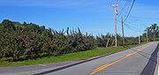 As the drive continues, the Catskill Aqueduct
crosses and recrosses the road several times and orchard
s become the primary agricultural
use of the adjoining land. This is one of the state's prime apple-growing regions, and several local apple farmers sell fresh-pressed cider
at their stands along the road in the fall.
The only traffic light along this stretch is at Ireland Corners, the slightly developed intersection with US 44
and NY 55
just east of Gardiner
. It marks the midway point between Wallkill and New Paltz
.
North of here, even better views of the Shawangunks open up with the observation tower
at Mohonk Mountain House
becoming prominent to the west. The Devil's Path
in the Greene County
Catskills appears to the north on clear enough days. Some vineyard
s join the orchards along the road, reflecting a developing local wine industry. The campus of SUNY New Paltz
starts to form a distinct skyline
to the north, and to the east the ridgeline of Illinois Mountain complements the Shawangunks.
 The views reach their peak at the New Paltz town line, then 208 descends from the rise it has reached. After some tight curves and bends, SUNY's athletic fields to the east herald entry into the village of New Paltz, where 208 becomes South Chestnut Street. A mile into the village, it reaches its northern terminus at a busy intersection at the edge of downtown with NY 299
and NY 32
. Continuing north from here puts a driver on the latter.
, then in Ulster County, from the Shawangunk
town line to what was then the Goshen
town line (today Hamptonburgh
). When it came to acquire a name, it was first Walden Road. In 1950, Maybrook renamed its portion Homestead Avenue in honor of early settlers whose houses stood or had stood along the road.
and Gardiner
in the 1930 renumbering of state highways in New York. The route was extended north to its current terminus in New Paltz
ca. 1934. Prior to 1930, the entirety of NY 208 was unnumbered. When U.S. Route 6 was rerouted to follow the new Quickway and NY 32
between Monroe
and Central Valley
in the mid-1950s, NY 208 was extended northeast from Monroe along the former routing of US 6 to Highland Mills
, where it terminated at NY 32. This extension of NY 208 remained in place until April 1, 1980, when ownership and maintenance of NY 208 from Schunnemunk Street in Monroe to Highland Mills was transferred to Orange County
as part of a large highway maintenance swap between the county and the state of New York
. Following the swap, NY 208 was rerouted within Monroe to follow its current alignment between NY 17M
and Schunnemunk Street while the former routing of NY 208 between Monroe and Highland Mills was redesignated as County Route 105.
In 2006, the portion of the route between Washingtonville and New Paltz was also designated as State Bicycle Route 208.
planned to link a spur route then called Route S4B from Paramus
up though Bergen County
to connect with NY 208 at Monroe. The road never got any further than Oakland
, but it was renumbered to Route 208 in 1953
.
 The village of Walden has noted, in its 2005 Comprehensive Plan, the difficulties created by the oblique intersection at the southern end of the Route 52 concurrency. Traffic on northbound 208 comes to a stop sign at the intersection, where 52 comes in from the right at a slightly lower grade and a sharp angle, with the view mostly blocked by a building. It is also just opposite one of two curb cuts for a busy Hess
-branded gas station. At rush hour
, the traffic light at the nearby northern end often backs cars up along 52 for some distance, making the turn into the gas station difficult, especially when vehicles on 52 make the left turn into the curb cut.
The layout of the intersection is very poor for trucks making this turn, and the congestion all these factors create has been forcing more drivers to resort to side streets, the village believes, since traffic counts
have been going up on 52 and 208 but down on the concurrency. It is hoping to work with the state DOT on marking an alternate route for trucks.
State highway
State highway, state road or state route can refer to one of three related concepts, two of them related to a state or provincial government in a country that is divided into states or provinces :#A...
located in southern New York
New York
New York is a state in the Northeastern region of the United States. It is the nation's third most populous state. New York is bordered by New Jersey and Pennsylvania to the south, and by Connecticut, Massachusetts and Vermont to the east...
in the United States
United States
The United States of America is a federal constitutional republic comprising fifty states and a federal district...
. The southern terminus is at an intersection with NY 17M
New York State Route 17M
New York State Route 17M is an east–west state highway in Orange County, New York, in the United States. It extends for from west of the city of Middletown to what is currently the north–south section of NY 17 just southeast of the village of Harriman...
in the Orange County
Orange County, New York
Orange County is a county located in the U.S. state of New York. It is part of the Poughkeepsie–Newburgh–Middletown, NY Metropolitan Statistical Area and is located at the northern reaches of the New York metropolitan area. The county sits in the state's scenic Mid-Hudson Region of the Hudson Valley...
village of Monroe
Monroe (village), New York
Monroe is a village in Orange County, New York, United States. The population was 7,780 at the 2000 census. It is part of the Poughkeepsie–Newburgh–Middletown, NY Metropolitan Statistical Area as well as the larger New York–Newark–Bridgeport, NY-NJ-CT-PA Combined Statistical...
. Its northern terminus is located at an intersection with NY 32
New York State Route 32
New York State Route 32 is a north–south state highway that extends for through the Hudson Valley and Capital District regions of the U.S. state of New York. It is a two-lane surface road for nearly its entire length, with few divided and no limited-access sections. From Harriman to Albany,...
and NY 299
New York State Route 299
New York State Route 299 is a short but important state route entirely within Ulster County, New York, United States. Centered around its interchange with the New York State Thruway outside New Paltz, it provides access from that road to the popular recreational attractions of the Shawangunk...
in the Ulster County
Ulster County, New York
Ulster County is a county located in the state of New York, USA. It sits in the state's Mid-Hudson Region of the Hudson Valley. As of the 2010 census, the population was 182,493. Recent population estimates completed by the United States Census Bureau for the 12-month period ending July 1 are at...
village of New Paltz
New Paltz (village), New York
New Paltz is a village in Ulster County in the U.S. state of New York. It is about north of New York City and south of Albany. The population was 6,818 at the 2010 census.The Village of New Paltz is located within the Town of New Paltz...
.
208 is a two-lane road for its entire length. While connecting two bustling villages and passing through three others, it is primarily a country road and offers a variety of scenery and points of interest, from fields and meadows to a riverside stretch and orchard
Orchard
An orchard is an intentional planting of trees or shrubs that is maintained for food production. Orchards comprise fruit or nut-producing trees which are grown for commercial production. Orchards are also sometimes a feature of large gardens, where they serve an aesthetic as well as a productive...
s devoted to apple
Apple
The apple is the pomaceous fruit of the apple tree, species Malus domestica in the rose family . It is one of the most widely cultivated tree fruits, and the most widely known of the many members of genus Malus that are used by humans. Apple grow on small, deciduous trees that blossom in the spring...
s. The northern third, between Wallkill
Wallkill, Ulster County, New York
Wallkill is a hamlet , generally identified as coterminous with ZIP code 12589, telephone exchange 895 in the 845 area code and most of the Wallkill Central School District located mostly in the eastern half of the Town of Shawangunk, Ulster County, New York but partly spilling over into adjacent...
and New Paltz, boasts a near-continuous view of the Shawangunk Ridge
Shawangunk Ridge
The Shawangunk Ridge , also known as the Shawangunk Mountains or The Gunks, is a ridge of bedrock in Ulster County, Sullivan County and Orange County in the state of New York, extending from the northernmost point of New Jersey to the Catskill Mountains.The ridgetop, which widens considerably at...
.
Route description
Orange County
From its southern terminus at a busy traffic light in MonroeMonroe (village), New York
Monroe is a village in Orange County, New York, United States. The population was 7,780 at the 2000 census. It is part of the Poughkeepsie–Newburgh–Middletown, NY Metropolitan Statistical Area as well as the larger New York–Newark–Bridgeport, NY-NJ-CT-PA Combined Statistical...
, Route 208 quickly crosses US 6
U.S. Route 6 in New York
U.S. Route 6 is a part of the U.S. Highway System that runs from Bishop, California, to Provincetown, Massachusetts. In New York, US 6 extends from the Pennsylvania state line at Port Jervis to the Connecticut state line east of Brewster...
and NY 17
New York State Route 17
New York State Route 17 is a state highway that extends for through the Southern Tier and Downstate regions of New York in the United States...
and then stays in the shade of the southwestern corner of Schunemunk Mountain
Schunemunk Mountain
Schunemunk Mountain is the highest mountain in Orange County, New York. The 1,664-foot summit is located in the town of Blooming Grove, with other portions in Cornwall and Woodbury. The community of Mountain Lodge Park is built up its western slope.The mountain is a popular recreational resource...
as it heads north to Washingtonville
Washingtonville, New York
Washingtonville is a village in Orange County, New York, United States. The population was 5,851 at the 2000 census. It is part of the Poughkeepsie–Newburgh–Middletown, NY Metropolitan Statistical Area as well as the larger New York–Newark–Bridgeport, NY-NJ-CT-PA Combined...
, remaining relatively straight through mostly wooded, undeveloped country with some views of the mountain. Round Hill Elementary School heralds the approach of the village. Shortly after entering Washingtonville, it intersects with NY 94
New York State Route 94
New York State Route 94 is a state highway entirely within Orange County in southern New York. The western terminus is at the New York-New Jersey state line, where it continues as NJ 94 for another to Columbia, New Jersey. Its eastern terminus is located at U.S. Route 9W in New Windsor....
.
Again it crosses the village line rather quickly, going through some sharp curves as it enters more open farmland. Here 208 also deviates from its northward course, heading much more westward as it picks up the headwaters of Moodna Creek
Moodna Creek
Moodna Creek is a small tributary of the Hudson River that drains eastern Orange County, New York. At 15.5 miles in length from its source at the confluence of Cromline Creek and Otter Kill west of Washingtonville, it is the longest stream located entirely within the county.Despite its small...
and passes its source, the confluence
Confluence
Confluence, in geography, describes the meeting of two or more bodies of water.Confluence may also refer to:* Confluence , a property of term rewriting systems...
of Otter Kill
Otter Kill
Otter Kill is a tributary of Moodna Creek that flows through central Orange County, New York, in the United States. Via the Moodna, which it forms at a confluence with Cromline Creek north of the village of Washingtonville, its waters eventually reach the Hudson River.The Otter Kill flows...
and Cromline Creek. Shortly afterwards, it again turns northward at the Sarah Wells Trail junction. Eventually the land surrounding the highway once again becomes more wooded and it goes through a short tunnel under the railroad tracks
Port Jervis Line (Metro-North)
The Metro-North Railroad Port Jervis Line is a predominantly single-track commuter rail line running from Suffern, New York to Port Jervis. At Suffern, the line continues south into New Jersey as NJ Transit's Main Line....
shared by Norfolk Southern and Metro-North
Metro-North Railroad
The Metro-North Commuter Railroad , trading as MTA Metro-North Railroad, or, more commonly, Metro-North, is a suburban commuter rail service that is run and managed by the Metropolitan Transportation Authority , an authority of New York State. It is the busiest commuter railroad in the United...
.
A mile or so past the tunnel, 208 abruptly reaches NY 207
New York State Route 207
New York State Route 207 is a state highway located entirely within Orange County, New York, in the United States. It serves as a connector between the village of Goshen and the city of Newburgh. It has for a long time provided the main access to Stewart International Airport...
outside the hamlet of Rock Tavern. 208 overlaps 207 for a hundred yards as the two roads pass small Brown's Pond and a weir
Weir
A weir is a small overflow dam used to alter the flow characteristics of a river or stream. In most cases weirs take the form of a barrier across the river that causes water to pool behind the structure , but allows water to flow over the top...
, then 208 once again turns left to go north alongside the pond, into some more open countryside. It passes the west boundary of Stewart State Forest, goes over a little-used rail spur, once part of the Wallkill Valley Railroad (WVRR) and then enters Maybrook
Maybrook, New York
Maybrook is a village in Orange County, New York, United States. The population was 3,084 at the 2000 census. It is part of the Poughkeepsie–Newburgh–Middletown, NY Metropolitan Statistical Area as well as the larger New York–Newark–Bridgeport, NY-NJ-CT-PA Combined...
, which it serves as the main street. A feature of this town is the large Yellow Freight terminal in its north end, continuing a tradition of importance in transportation that began with the village's origins as a major regional rail hub.
Interstate 84 in New York
Interstate 84 is a part of the Interstate Highway System that runs from Dunmore, Pennsylvania, to Sturbridge, Massachusetts, in the Eastern United States. In New York, I-84 extends from the Pennsylvania state line at Port Jervis to the Connecticut state line east of Brewster...
. This exit, the only one for several miles in either direction on the interstate, contains several businesses. Here, for the only point on its entire length, 208 swells beyond two lanes with the addition of turn lanes for the interstate's onramps. There is a heavy truck presence at the Rt. 208 and I-84 interchange. Several companies have built warehouse facilities on Neelytown Road, including Home Depot, Cardinal Health and Do It Best Corporation. Also found in this area is Federal Express Freight, Yellow Freight and several other national trucking firms.
North of I-84, the road remains a two-lane until it intersects with NY 17K
New York State Route 17K
New York State Route 17K is an east–west state highway located within Orange County, New York, in the United States. It extends for from an intersection with County Route 76 east of Bloomingburg to a junction with U.S. Route 9W midway across the city of Newburgh...
at Scotts Corners. This intersection was redesigned and upgraded in 2008 to accommodate left and right turn lanes.
Walden, New York
Walden is the largest of three villages of the Town of Montgomery in Orange County, New York, United States. The population was 6,978 at the 2010 census. It has the ZIP Code 12586 and the 778 telephone exchange within the 845 area code...
, the largest community on 208 after Monroe. After crossing the old WVRR main line, now the north end of a lightly used freight spur, it becomes Orange Avenue with a mix of residential and commercial properties. In the center of town NY 52
New York State Route 52
New York State Route 52 is a long state highway in the southeastern part of New York in the United States. It generally runs from west to east, beginning at the Pennsylvania state line in the Delaware River near Narrowsburg, crossing the Hudson River on the Newburgh-Beacon Bridge, and ending...
comes in from the east at an oblique angle more like a merger than a junction; traffic at rush hour there is made more difficult by vehicles attempting to cross 52 and enter the adjacent Hess station as well as a local one-way side street. Since 52 comes in at a slightly lower elevation, it has the right of way, guaranteed by the stop sign
Stop sign
A Stop sign is a traffic sign to notify drivers that they must stop before proceeding.-Specifications:The Vienna Convention on Road Signs and Signals proposed standard stop sign diameters of 0.6, 0.9 or 1.2 metres. UK and New Zealand stop signs are 750, 900 or 1200 mm, according to sign...
greeting drivers on 208.
The two roads make an unsigned concurrency for about two blocks of East Main Street before a traffic light
Traffic light
Traffic lights, which may also be known as stoplights, traffic lamps, traffic signals, signal lights, robots or semaphore, are signalling devices positioned at road intersections, pedestrian crossings and other locations to control competing flows of traffic...
separates them; traffic on 208 turns right, on Ulster Avenue, to continue north. This takes the traveler past some of Walden's older homes and Most Precious Blood Catholic school
Catholic school
Catholic schools are maintained parochial schools or education ministries of the Catholic Church. the Church operates the world's largest non-governmental school system...
before finally leaving the village at the Tin Brook
Tin Brook
Tin Brook is an tributary of the Wallkill River almost entirely located in the town of Montgomery in Orange County, New York, United States. Near its mouth it flows through the village of Walden...
bridge, whereupon it almost immediately bends westward at the Lake Osiris Road junction for a short distance, curving north again when it reaches the Wallkill River
Wallkill River
The Wallkill River, a tributary of the Hudson, drains Lake Mohawk in Sparta, New Jersey, flowing from there generally northeasterly to Rondout Creek in New York, near Rosendale, with the combined flows reaching the Hudson at Kingston....
.
Ulster County
The mile of highway along the Wallkill is at first wooded and curvy but then offers many pleasant riverside scenes. A burned-out former Borden Cheese factory is the last highlight before crossing the county line. This section of the river is popular with local fishermenAngling
Angling is a method of fishing by means of an "angle" . The hook is usually attached to a fishing line and the line is often attached to a fishing rod. Fishing rods are usually fitted with a fishing reel that functions as a mechanism for storing, retrieving and paying out the line. The hook itself...
and there are many informal parking spots available (In winter
Winter
Winter is the coldest season of the year in temperate climates, between autumn and spring. At the winter solstice, the days are shortest and the nights are longest, with days lengthening as the season progresses after the solstice.-Meteorology:...
s when it is cold enough for the river to freeze over, snowmobile
Snowmobile
A snowmobile, also known in some places as a snowmachine, or sled,is a land vehicle for winter travel on snow. Designed to be operated on snow and ice, they require no road or trail. Design variations enable some machines to operate in deep snow or forests; most are used on open terrain, including...
trails can be seen on the ice). A Ulster County sheriff's substation is the first in a string of buildings that indicate the road has reached the hamlet of Wallkill
Wallkill, Ulster County, New York
Wallkill is a hamlet , generally identified as coterminous with ZIP code 12589, telephone exchange 895 in the 845 area code and most of the Wallkill Central School District located mostly in the eastern half of the Town of Shawangunk, Ulster County, New York but partly spilling over into adjacent...
.
Immediately east of the hamlet's business district, at Wallkill Library it turns right onto Main Street and takes a more easterly course out of town, past some rolling fields and John G. Borden Middle School(Was Wallkill Middle School)
John G. Borden Middle School
John G. Borden Middle School in Wallkill, New York, educates the seventh- and eighth-graders of the Wallkill Central School District. It is located along NY 208 on the east side of the hamlet, not far from the junction with NY 300....
. At the only traffic light here, the northern terminus of NY 300
New York State Route 300
New York State Route 300 is a state highway located west of the city of Newburgh in the Hudson Valley of New York in the United States. The southern terminus of the route is at a five-way intersection with NY 32 and NY 94 in the hamlet of Vails Gate...
, it regains its northward orientation, which it will keep for its final 11 miles (17.6 km) to New Paltz.
Wallkill Correctional Facility
The Wallkill Correctional Facility is a medium security prison in New York state in the USA. The prison is located just north of the hamlet of Wallkill in the Shawangunk in Ulster County, New York.- Address :Wallkill Correctional Facility Box G...
and Shawangunk
Shawangunk Correctional Facility
Shawangunk Correctional Facility is a maximum security prison for males located in Ulster County, New York in the United States.- History :The prison was constructed in 1983 to expand the maximum security capabilities of the state prison system and was located near the existing Wallkill...
state prisons and the panoramic view of the Shawangunk Ridge
Shawangunk Ridge
The Shawangunk Ridge , also known as the Shawangunk Mountains or The Gunks, is a ridge of bedrock in Ulster County, Sullivan County and Orange County in the state of New York, extending from the northernmost point of New Jersey to the Catskill Mountains.The ridgetop, which widens considerably at...
across the river valley that continues most of the way to New Paltz (Sometimes the summit of Slide Mountain
Slide Mountain (New York)
Slide Mountain is the highest peak in the Catskills. It is located in the Town of Shandaken in Ulster County, in southern New York. While the contour line on topographic maps is generally accepted as its height, the exact elevation of the summit has never been officially determined by the U.S...
, the Catskill Mountains
Catskill Mountains
The Catskill Mountains, an area in New York State northwest of New York City and southwest of Albany, are a mature dissected plateau, an uplifted region that was subsequently eroded into sharp relief. They are an eastward continuation, and the highest representation, of the Allegheny Plateau...
' highest peak, is visible over the ridge).
Catskill Aqueduct
The Catskill Aqueduct, part of the New York City water supply system, brings water from the Catskill Mountains to Yonkers where it connects to other parts of the system.-History:Construction commenced in 1907...
crosses and recrosses the road several times and orchard
Orchard
An orchard is an intentional planting of trees or shrubs that is maintained for food production. Orchards comprise fruit or nut-producing trees which are grown for commercial production. Orchards are also sometimes a feature of large gardens, where they serve an aesthetic as well as a productive...
s become the primary agricultural
Agriculture
Agriculture is the cultivation of animals, plants, fungi and other life forms for food, fiber, and other products used to sustain life. Agriculture was the key implement in the rise of sedentary human civilization, whereby farming of domesticated species created food surpluses that nurtured the...
use of the adjoining land. This is one of the state's prime apple-growing regions, and several local apple farmers sell fresh-pressed cider
Cider
Cider or cyder is a fermented alcoholic beverage made from apple juice. Cider varies in alcohol content from 2% abv to 8.5% abv or more in traditional English ciders. In some regions, such as Germany and America, cider may be termed "apple wine"...
at their stands along the road in the fall.
The only traffic light along this stretch is at Ireland Corners, the slightly developed intersection with US 44
U.S. Route 44
U.S. Route 44 is an east–west United States highway that runs for 237 miles through four states in the Northeastern region of the United States. The western terminus is at U.S. Route 209 and New York State Route 55 in Kerhonkson, a hamlet in the Hudson Valley region of New York...
and NY 55
New York State Route 55
New York State Route 55 is a state highway in southern New York, running from the Pennsylvania state line at the Delaware River in Barryville to the Connecticut state line at Wingdale...
just east of Gardiner
Gardiner (CDP), New York
Gardiner is a hamlet in Ulster County, New York, USA. The population was 856 at the 2000 census.The community is near the center of the Town of Gardiner on routes 44 and 55.-Geography:...
. It marks the midway point between Wallkill and New Paltz
New Paltz (village), New York
New Paltz is a village in Ulster County in the U.S. state of New York. It is about north of New York City and south of Albany. The population was 6,818 at the 2010 census.The Village of New Paltz is located within the Town of New Paltz...
.
North of here, even better views of the Shawangunks open up with the observation tower
Observation tower
An observation tower is a structure used to view events from a long distance and to create a full 360 degree range of vision. They are usually at least tall and made from stone, iron, and wood. Many modern towers are also used as TV towers, restaurants, or churches...
at Mohonk Mountain House
Mohonk Mountain House
The Mohonk Mountain House also known as Lake Mohonk Mountain House, is a historic American resort hotel located on the Shawangunk Ridge in Ulster County, New York. Its prominent location in the town of New Paltz is just beyond the southern border of the Catskill Mountains on the western side of the...
becoming prominent to the west. The Devil's Path
Devil's Path (Catskills)
The Devil's Path is the name of a mountain range and hiking trail in the Greene County portion of New York's Catskill Mountains. The mountains commonly considered to be part of the Devil's Path are, from west to east, West Kill, Hunter, Plateau, Sugarloaf, Twin, and Indian Head.The name comes from...
in the Greene County
Greene County, New York
Greene County is a county located in the U.S. state of New York. Its name is in honor of the American Revolutionary War general Nathanael Greene. Its county seat is Catskill...
Catskills appears to the north on clear enough days. Some vineyard
Vineyard
A vineyard is a plantation of grape-bearing vines, grown mainly for winemaking, but also raisins, table grapes and non-alcoholic grape juice...
s join the orchards along the road, reflecting a developing local wine industry. The campus of SUNY New Paltz
State University of New York at New Paltz
The State University of New York at New Paltz, known as SUNY New Paltz for short, is a public university in New Paltz, New York. It was founded in 1828 as the School for teaching of classics. In 1885, the New Paltz Normal and Training School was established as a school to prepare teachers for the...
starts to form a distinct skyline
Skyline
A skyline is the overall or partial view of a city's tall buildings and structures consisting of many skyscrapers in front of the sky in the background. It can also be described as the artificial horizon that a city's overall structure creates. Skylines serve as a kind of fingerprint of a city, as...
to the north, and to the east the ridgeline of Illinois Mountain complements the Shawangunks.
New York State Route 299
New York State Route 299 is a short but important state route entirely within Ulster County, New York, United States. Centered around its interchange with the New York State Thruway outside New Paltz, it provides access from that road to the popular recreational attractions of the Shawangunk...
and NY 32
New York State Route 32
New York State Route 32 is a north–south state highway that extends for through the Hudson Valley and Capital District regions of the U.S. state of New York. It is a two-lane surface road for nearly its entire length, with few divided and no limited-access sections. From Harriman to Albany,...
. Continuing north from here puts a driver on the latter.
History
The earliest of the road segments that make up Route 208 dates to 1735, when a "Highway Deed" was drawn up for a segment in the Town of MontgomeryMontgomery (town), New York
Montgomery is a town in Orange County, New York, United States. The population was 20,891 at the 2000 census. It was named in honor of Richard Montgomery, an American Revolutionary War general killed in 1775 at the Battle of Quebec....
, then in Ulster County, from the Shawangunk
Shawangunk, New York
Shawangunk is a town in southwestern Ulster County, New York, United States. The population was 12,022 at the 2000 census. Like the neighboring mountain range, for which it is named, it is pronounced either as the Munsee Lenape, Shawangunk , or as the colonial Shongum by local residents...
town line to what was then the Goshen
Goshen (town), New York
Goshen is a town in Orange County, New York, United States. The population was 12,913 at the 2000 census.The Town of Goshen contains a village also called Goshen, the county seat of Orange County. The town is centrally located in the county....
town line (today Hamptonburgh
Hamptonburgh, New York
Hamptonburgh is a town located in the northern part of Orange County, New York, United States. The population was 4,686 at the 2000 census. The name was provided by an early settler, William Bull....
). When it came to acquire a name, it was first Walden Road. In 1950, Maybrook renamed its portion Homestead Avenue in honor of early settlers whose houses stood or had stood along the road.
Designation
NY 208 was assigned to its current routing between MonroeMonroe (village), New York
Monroe is a village in Orange County, New York, United States. The population was 7,780 at the 2000 census. It is part of the Poughkeepsie–Newburgh–Middletown, NY Metropolitan Statistical Area as well as the larger New York–Newark–Bridgeport, NY-NJ-CT-PA Combined Statistical...
and Gardiner
Gardiner, New York
Gardiner is a town in Ulster County, New York, USA. The population was 5,238 at the 2000 census.The Town of Gardiner is in the south-central part of the county.- History :...
in the 1930 renumbering of state highways in New York. The route was extended north to its current terminus in New Paltz
New Paltz (village), New York
New Paltz is a village in Ulster County in the U.S. state of New York. It is about north of New York City and south of Albany. The population was 6,818 at the 2010 census.The Village of New Paltz is located within the Town of New Paltz...
ca. 1934. Prior to 1930, the entirety of NY 208 was unnumbered. When U.S. Route 6 was rerouted to follow the new Quickway and NY 32
New York State Route 32
New York State Route 32 is a north–south state highway that extends for through the Hudson Valley and Capital District regions of the U.S. state of New York. It is a two-lane surface road for nearly its entire length, with few divided and no limited-access sections. From Harriman to Albany,...
between Monroe
Monroe (village), New York
Monroe is a village in Orange County, New York, United States. The population was 7,780 at the 2000 census. It is part of the Poughkeepsie–Newburgh–Middletown, NY Metropolitan Statistical Area as well as the larger New York–Newark–Bridgeport, NY-NJ-CT-PA Combined Statistical...
and Central Valley
Central Valley, New York
Central Valley is a hamlet in Orange County, New York, United States. The population was 1,857 at the 2000 census, at which time it was a census-designated place...
in the mid-1950s, NY 208 was extended northeast from Monroe along the former routing of US 6 to Highland Mills
Highland Mills, New York
Highland Mills is a hamlet in Orange County, New York, United States. The population was 3,468 at the 2000 census, at which time it was a census-designated place...
, where it terminated at NY 32. This extension of NY 208 remained in place until April 1, 1980, when ownership and maintenance of NY 208 from Schunnemunk Street in Monroe to Highland Mills was transferred to Orange County
Orange County, New York
Orange County is a county located in the U.S. state of New York. It is part of the Poughkeepsie–Newburgh–Middletown, NY Metropolitan Statistical Area and is located at the northern reaches of the New York metropolitan area. The county sits in the state's scenic Mid-Hudson Region of the Hudson Valley...
as part of a large highway maintenance swap between the county and the state of New York
New York
New York is a state in the Northeastern region of the United States. It is the nation's third most populous state. New York is bordered by New Jersey and Pennsylvania to the south, and by Connecticut, Massachusetts and Vermont to the east...
. Following the swap, NY 208 was rerouted within Monroe to follow its current alignment between NY 17M
New York State Route 17M
New York State Route 17M is an east–west state highway in Orange County, New York, in the United States. It extends for from west of the city of Middletown to what is currently the north–south section of NY 17 just southeast of the village of Harriman...
and Schunnemunk Street while the former routing of NY 208 between Monroe and Highland Mills was redesignated as County Route 105.
In 2006, the portion of the route between Washingtonville and New Paltz was also designated as State Bicycle Route 208.
New Jersey connection
In the 1940s, the New Jersey Department of TransportationNew Jersey Department of Transportation
The New Jersey Department of Transportation is the agency responsible for transportation issues and policy in New Jersey. It is headed by the Commissioner of Transportation...
planned to link a spur route then called Route S4B from Paramus
Paramus, New Jersey
Paramus is a borough in Bergen County, New Jersey, United States. As of the 2010 United States Census, the borough population was 26,342. A suburb of New York City, Paramus is located between 15–20 miles northwest of Midtown Manhattan and approximately west of Upper Manhattan.Paramus is one of...
up though Bergen County
Bergen County, New Jersey
Bergen County is the most populous county of the state of New Jersey, United States. As of the 2010 United States Census, its population was 905,116. The county is part of the New York City Metropolitan Area. Its county seat is Hackensack...
to connect with NY 208 at Monroe. The road never got any further than Oakland
Oakland, New Jersey
Oakland is a borough in Bergen County, New Jersey, United States. As of the 2010 United States Census, the borough population was 12,754.Oakland was incorporated as a borough by an Act of the New Jersey Legislature on April 8, 1902, from portions of Franklin Township.-History:The Van Allen House...
, but it was renumbered to Route 208 in 1953
1953 New Jersey state highway renumbering
On January 1, 1953, the New Jersey Department of Transportation renumbered many of the State Routes. A few rules were followed in deciding what to renumber:...
.
Future
Hess Corporation
The Hess Corporation is an integrated oil company based in New York City. The company explores, produces, transports, and refines crude oil and natural gas. Vertically completing the logistical chain, about 1,360 Hess branded filling stations market gasoline to consumers in 16 states along the...
-branded gas station. At rush hour
Rush hour
A rush hour or peak hour is a part of the day during which traffic congestion on roads and crowding on public transport is at its highest. Normally, this happens twice a day—once in the morning and once in the evening, the times during when the most people commute...
, the traffic light at the nearby northern end often backs cars up along 52 for some distance, making the turn into the gas station difficult, especially when vehicles on 52 make the left turn into the curb cut.
The layout of the intersection is very poor for trucks making this turn, and the congestion all these factors create has been forcing more drivers to resort to side streets, the village believes, since traffic counts
Annual average daily traffic
Average Annual daily traffic, abbreviated AADT, is a measure used primarily in transportation planning and transportation engineering. It is the total volume of vehicle traffic of a highway or road for a year divided by 365 days. AADT is a useful and simple measurement of how busy the road is...
have been going up on 52 and 208 but down on the concurrency. It is hoping to work with the state DOT on marking an alternate route for trucks.