

New York - Pennsylvania Border
Encyclopedia
U.S. state
A U.S. state is any one of the 50 federated states of the United States of America that share sovereignty with the federal government. Because of this shared sovereignty, an American is a citizen both of the federal entity and of his or her state of domicile. Four states use the official title of...
s of New York
New York
New York is a state in the Northeastern region of the United States. It is the nation's third most populous state. New York is bordered by New Jersey and Pennsylvania to the south, and by Connecticut, Massachusetts and Vermont to the east...
and Pennsylvania
Pennsylvania
The Commonwealth of Pennsylvania is a U.S. state that is located in the Northeastern and Mid-Atlantic regions of the United States. The state borders Delaware and Maryland to the south, West Virginia to the southwest, Ohio to the west, New York and Ontario, Canada, to the north, and New Jersey to...
. It has three sections:
- along the center line of the Delaware RiverDelaware RiverThe Delaware River is a major river on the Atlantic coast of the United States.A Dutch expedition led by Henry Hudson in 1609 first mapped the river. The river was christened the South River in the New Netherland colony that followed, in contrast to the North River, as the Hudson River was then...
from the tri-point with New JerseyNew JerseyNew Jersey is a state in the Northeastern and Middle Atlantic regions of the United States. , its population was 8,791,894. It is bordered on the north and east by the state of New York, on the southeast and south by the Atlantic Ocean, on the west by Pennsylvania and on the southwest by Delaware...
at the confluence of the Delaware with the Neversink RiverNeversink RiverThe Neversink River is a tributary of the Delaware River in southeastern New York in the United States...
in Port Jervis, New YorkPort Jervis, New YorkPort Jervis is a city on the Delaware River in western Orange County, New York, with a population of 8,860 at the 2000 census. The communities of Deerpark, Huguenot, Sparrowbush, and Greenville are adjacent to Port Jervis, and the towns of Montague, New Jersey and Matamoras, Pennsylvania face the...
to the 42nd parallel north42nd parallel northThe 42nd parallel north is a circle of latitude that is 42 degrees north of the Earth's equatorial plane. It crosses Europe, the Mediterranean Sea, Asia, the Pacific Ocean, North America, and the Atlantic Ocean....
between Hancock, New YorkHancock, New YorkHancock, New York may refer to one of the following locations in New York State:*Hancock , New York*Hancock , New York...
and Deposit, New YorkDeposit, New YorkDeposit, New York may refer to:*Deposit , New York, in Delaware County*Deposit , New York, located partly within the town to the north and partly in Broome County...
about 2.8 km downstream from Hale Eddy; above HancockHancock, New YorkHancock, New York may refer to one of the following locations in New York State:*Hancock , New York*Hancock , New York...
this is the West branch of the DelawareWest Branch Delaware RiverThe West Branch Delaware River, approximately 90 mi long in the U.S. states of New York and Pennsylvania, is one of the two branches, along with the East Branch, that join to form the Delaware River...
; - across the 42nd parallel north42nd parallel northThe 42nd parallel north is a circle of latitude that is 42 degrees north of the Earth's equatorial plane. It crosses Europe, the Mediterranean Sea, Asia, the Pacific Ocean, North America, and the Atlantic Ocean....
to the corner of the Erie TriangleErie TriangleThe Erie Triangle is a tract of American land that was the subject of several competing colonial-era claims and which was eventually acquired by the U.S. federal government and sold to Pennsylvania so that the state would have access to a freshwater port on Lake Erie...
; - north along the east boundary of the Erie TriangleErie TriangleThe Erie Triangle is a tract of American land that was the subject of several competing colonial-era claims and which was eventually acquired by the U.S. federal government and sold to Pennsylvania so that the state would have access to a freshwater port on Lake Erie...
to Lake ErieLake ErieLake Erie is the fourth largest lake of the five Great Lakes in North America, and the tenth largest globally. It is the southernmost, shallowest, and smallest by volume of the Great Lakes and therefore also has the shortest average water residence time. It is bounded on the north by the...
.
The survey of the 42nd parallel north
42nd parallel north
The 42nd parallel north is a circle of latitude that is 42 degrees north of the Earth's equatorial plane. It crosses Europe, the Mediterranean Sea, Asia, the Pacific Ocean, North America, and the Atlantic Ocean....
was carried out in 1785-6 and accepted by the two states in 1787. Surveying technique was not so good, so that this boundary wanders around on both sides of the true parallel. The 82nd mile stone was used as the starting point of the Preemption Line
Preemption Line
The Preemption Line divides the Indian lands of western New York State awarded to New York from those awarded to Commonwealth of Massachusetts by the Treaty of Hartford of 1786...
defined in the Treaty of Hartford
Treaty of Hartford
The term Treaty of Hartford applies to three historic agreements negotiated at Hartford, Connecticut. The 1638 treaty divided the spoils of the Pequot War. The 1650 treaty defined a border between the Dutch Nieuw Amsterdam and English settlers in Connecticut...
in 1786 to separate Massachusetts
Massachusetts
The Commonwealth of Massachusetts is a state in the New England region of the northeastern United States of America. It is bordered by Rhode Island and Connecticut to the south, New York to the west, and Vermont and New Hampshire to the north; at its east lies the Atlantic Ocean. As of the 2010...
and New York State land claims in Western New York
Western New York
Western New York is the westernmost region of the state of New York. It includes the cities of Buffalo, Rochester, Niagara Falls, the surrounding suburbs, as well as the outlying rural areas of the Great Lakes lowlands, the Genesee Valley, and the Southern Tier. Some historians, scholars and others...
.
Erie Triangle
The Erie Triangle is a tract of American land that was the subject of several competing colonial-era claims and which was eventually acquired by the U.S. federal government and sold to Pennsylvania so that the state would have access to a freshwater port on Lake Erie...
boundary was by the top surveyor in the USA of the time, Andrew Ellicott
Andrew Ellicott
Andrew Ellicott was a U.S. surveyor who helped map many of the territories west of the Appalachians, surveyed the boundaries of the District of Columbia, continued and completed Pierre Charles L'Enfant's work on the plan for Washington, D.C., and served as a teacher in survey methods for...
in 1789.
The starting point of the 42nd parallel north
42nd parallel north
The 42nd parallel north is a circle of latitude that is 42 degrees north of the Earth's equatorial plane. It crosses Europe, the Mediterranean Sea, Asia, the Pacific Ocean, North America, and the Atlantic Ocean....
line is in the Delaware River
Delaware River
The Delaware River is a major river on the Atlantic coast of the United States.A Dutch expedition led by Henry Hudson in 1609 first mapped the river. The river was christened the South River in the New Netherland colony that followed, in contrast to the North River, as the Hudson River was then...
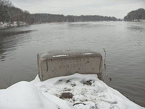
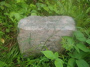
at the northeast corner of Wayne County, PA at 41°59′57″ N, 75°21′35″ W WGS 84. The initial surveyor's monument is just west of Faulkner Road at 41°59′58″ N, 75°21′43″ W.
The corner point of the Erie Triangle
Erie Triangle
The Erie Triangle is a tract of American land that was the subject of several competing colonial-era claims and which was eventually acquired by the U.S. federal government and sold to Pennsylvania so that the state would have access to a freshwater port on Lake Erie...
in modern coordinates is 41°59′55″ N, 79°45′43″ W.
The distance along the east-west line is approximately 363.49 km (225.86 statute miles)
The counties that surround the east-west line are known collectively as the Twin Tiers
Twin Tiers
The Twin Tiers is a geographical term that refers to the collective counties that lie on the New York-Pennsylvania border adjacent to the 42nd parallel north....
.
See also
- Erie TriangleErie TriangleThe Erie Triangle is a tract of American land that was the subject of several competing colonial-era claims and which was eventually acquired by the U.S. federal government and sold to Pennsylvania so that the state would have access to a freshwater port on Lake Erie...
- Twin TiersTwin TiersThe Twin Tiers is a geographical term that refers to the collective counties that lie on the New York-Pennsylvania border adjacent to the 42nd parallel north....
- Northern Tier (Pennsylvania)
- Southern TierSouthern TierThe Southern Tier is a geographical term that refers to the counties of New York State west of the Catskill Mountains along the northern border of Pennsylvania. It is a loosely defined term that generally includes the counties that border Pennsylvania west of Delaware County inclusive...