
Pine Bush, New York
Encyclopedia
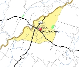
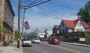
Pine Bush is a hamlet
(and census-designated place
) located in the Town of Crawford
, and Shawangunk, New York
, in Orange/Ulster Counties, New York, U.S.
, roughly coterminous with the 12566 ZIP code
and 744 telephone exchange
in the 845 area code
(both of which spill over into adjacent regions of the Town of Shawangunk
in Ulster County
(Another regional identifier, the Pine Bush Central School District
, takes in part of the Town of Mamakating
in Sullivan County
as well). The population was 1,539 at the 2000 census.
Pine Bush is part of the Poughkeepsie
–Newburgh
–Middletown
, NY Metropolitan Statistical Area
as well as the larger New York
–Newark
–Bridgeport
, NY-NJ
-CT
-PA
Combined Statistical Area
.
 Pine Bush is located at 41°36′32"N 74°17′55"W (41.608823, -74.298726).
According to the United States Census Bureau
, the CDP has a total area of 2.1 square miles (5.4 km²), all land.
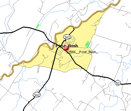
Pine Bush is on the border of Ulster County, New York
and Orange County. The Shawangunk Kill
, a small river, marks this boundary. It is located at the intersection of New York State Route 52
and New York State Route 302
.
of 2000, there were 1,539 people, 612 households, and 411 families residing in the CDP. The population density
was 734.4 per square mile (283.0/km²). There were 654 housing units at an average density of 312.1/sq mi (120.2/km²). The racial makeup of the CDP was 94.74% White, 0.78% African American, 0.06% Native American, 1.17% Asian, 0.06% Pacific Islander, 1.04% from other races
, and 2.14% from two or more races. Hispanic or Latino of any race were 4.09% of the population.
There were 612 households out of which 35.6% had children under the age of 18 living with them, 48.2% were married couples
living together, 14.1% had a female householder with no husband present, and 32.7% were non-families. 27.8% of all households were made up of individuals and 13.2% had someone living alone who was 65 years of age or older. The average household size was 2.51 and the average family size was 3.08.
In the CDP the population was spread out with 27.9% under the age of 18, 7.1% from 18 to 24, 29.6% from 25 to 44, 22.7% from 45 to 64, and 12.7% who were 65 years of age or older. The median age was 36 years. For every 100 females there were 85.9 males. For every 100 females age 18 and over, there were 80.6 males.
The median income for a household in the CDP was $47,679, and the median income for a family was $55,815. Males had a median income of $38,203 versus $30,577 for females. The per capita income
for the CDP was $22,626. About 4.3% of families and 4.5% of the population were below the poverty line, including 4.2% of those under age 18 and 4.3% of those age 65 or over.
, Sullivan
, and Orange
counties. The system, one of the largest in the area, includes four elementary schools, two middle schools and a high school.
Hamlet (place)
A hamlet is usually a rural settlement which is too small to be considered a village, though sometimes the word is used for a different sort of community. Historically, when a hamlet became large enough to justify building a church, it was then classified as a village...
(and census-designated place
Census-designated place
A census-designated place is a concentration of population identified by the United States Census Bureau for statistical purposes. CDPs are delineated for each decennial census as the statistical counterparts of incorporated places such as cities, towns and villages...
) located in the Town of Crawford
Crawford, New York
Crawford is a town in Orange County, New York, USA. The population was 7,875 at the 2000 census. The name comes a settler who gave his name to a community in the town now called Pine Bush....
, and Shawangunk, New York
Shawangunk, New York
Shawangunk is a town in southwestern Ulster County, New York, United States. The population was 12,022 at the 2000 census. Like the neighboring mountain range, for which it is named, it is pronounced either as the Munsee Lenape, Shawangunk , or as the colonial Shongum by local residents...
, in Orange/Ulster Counties, New York, U.S.
United States
The United States of America is a federal constitutional republic comprising fifty states and a federal district...
, roughly coterminous with the 12566 ZIP code
ZIP Code
ZIP codes are a system of postal codes used by the United States Postal Service since 1963. The term ZIP, an acronym for Zone Improvement Plan, is properly written in capital letters and was chosen to suggest that the mail travels more efficiently, and therefore more quickly, when senders use the...
and 744 telephone exchange
Telephone exchange
In the field of telecommunications, a telephone exchange or telephone switch is a system of electronic components that connects telephone calls...
in the 845 area code
Area code 845
Area code 845 is a telephone area code which serves the Hudson Valley counties of Rockland, Putnam, Orange, most of Dutchess, Ulster, and Sullivan, plus parts of Delaware, Greene, and Columbia counties...
(both of which spill over into adjacent regions of the Town of Shawangunk
Shawangunk, New York
Shawangunk is a town in southwestern Ulster County, New York, United States. The population was 12,022 at the 2000 census. Like the neighboring mountain range, for which it is named, it is pronounced either as the Munsee Lenape, Shawangunk , or as the colonial Shongum by local residents...
in Ulster County
Ulster County, New York
Ulster County is a county located in the state of New York, USA. It sits in the state's Mid-Hudson Region of the Hudson Valley. As of the 2010 census, the population was 182,493. Recent population estimates completed by the United States Census Bureau for the 12-month period ending July 1 are at...
(Another regional identifier, the Pine Bush Central School District
Pine Bush Central School District
The Pine Bush Central School District is in Pine Bush, New York, United States, and spans all of the Town of Crawford and includes part of six other townships in Orange, Sullivan, and Ulster counties. The student enrollment for the district is over 6,200. The district was established in 1938...
, takes in part of the Town of Mamakating
Mamakating, New York
Mamakating is a town in Sullivan County, New York, United States. The population was 11,002 at the 2000 census.The Town of Mamakating is in the southeast part of the county.- History :...
in Sullivan County
Sullivan County, New York
Sullivan County is a county located in the U.S. state of New York. As of the 2010 census, the population was 77,547. The county seat is Monticello. The name is in honor of Major General John Sullivan, who was a hero in the American Revolutionary War...
as well). The population was 1,539 at the 2000 census.
Pine Bush is part of the Poughkeepsie
Poughkeepsie (city), New York
Poughkeepsie is a city in the state of New York, United States, which serves as the county seat of Dutchess County. Poughkeepsie is located in the Hudson River Valley midway between New York City and Albany...
–Newburgh
Newburgh (city), New York
Newburgh is a city located in Orange County, New York, United States, north of New York City, and south of Albany, on the Hudson River. Newburgh is a principal city of the Poughkeepsie-Newburgh-Middletown metropolitan area, which includes all of Dutchess and Orange counties. The Newburgh area was...
–Middletown
Middletown, Orange County, New York
Middletown is a city in Orange County, New York, United States. It lies in New York's Hudson Valley region, near the Wallkill River and the foothills of the Shawangunk Mountains. Middletown is situated between Port Jervis and Newburgh, New York. The city's population was 25,388 at the 2000 census...
, NY Metropolitan Statistical Area
Poughkeepsie-Newburgh-Middletown metropolitan area
The Poughkeepsie–Newburgh–Middletown Metropolitan Statistical Area, as defined by the United States Census Bureau, is an area consisting of two counties in New York's Hudson Valley, with the cities of Poughkeepsie, Newburgh, and Middletown, and the Arlington census-designated place as...
as well as the larger New York
New York City
New York is the most populous city in the United States and the center of the New York Metropolitan Area, one of the most populous metropolitan areas in the world. New York exerts a significant impact upon global commerce, finance, media, art, fashion, research, technology, education, and...
–Newark
Newark, New Jersey
Newark is the largest city in the American state of New Jersey, and the seat of Essex County. As of the 2010 United States Census, Newark had a population of 277,140, maintaining its status as the largest municipality in New Jersey. It is the 68th largest city in the U.S...
–Bridgeport
Bridgeport, Connecticut
Bridgeport is the most populous city in the U.S. state of Connecticut. Located in Fairfield County, the city had an estimated population of 144,229 at the 2010 United States Census and is the core of the Greater Bridgeport area...
, NY-NJ
New Jersey
New Jersey is a state in the Northeastern and Middle Atlantic regions of the United States. , its population was 8,791,894. It is bordered on the north and east by the state of New York, on the southeast and south by the Atlantic Ocean, on the west by Pennsylvania and on the southwest by Delaware...
-CT
Connecticut
Connecticut is a state in the New England region of the northeastern United States. It is bordered by Rhode Island to the east, Massachusetts to the north, and the state of New York to the west and the south .Connecticut is named for the Connecticut River, the major U.S. river that approximately...
-PA
Pennsylvania
The Commonwealth of Pennsylvania is a U.S. state that is located in the Northeastern and Mid-Atlantic regions of the United States. The state borders Delaware and Maryland to the south, West Virginia to the southwest, Ohio to the west, New York and Ontario, Canada, to the north, and New Jersey to...
Combined Statistical Area
New York metropolitan area
The New York metropolitan area, also known as Greater New York, or the Tri-State area, is the region that composes of New York City and the surrounding region...
.
History
The community was one of the four early nineteenth century settlements in the town. It has previously been known as "Shawangunk," "Crawford," and "Bloomfield." Currently, there is another community called "Crawford," located to the northwest in bordering Ulster County. It was an early terminus for a short line railroad, the Middletown & Crawford Railroad. This line was bought by the Erie railroad, which served the town until the 1970s.Geography
According to the United States Census Bureau
United States Census Bureau
The United States Census Bureau is the government agency that is responsible for the United States Census. It also gathers other national demographic and economic data...
, the CDP has a total area of 2.1 square miles (5.4 km²), all land.
Pine Bush is on the border of Ulster County, New York
Ulster County, New York
Ulster County is a county located in the state of New York, USA. It sits in the state's Mid-Hudson Region of the Hudson Valley. As of the 2010 census, the population was 182,493. Recent population estimates completed by the United States Census Bureau for the 12-month period ending July 1 are at...
and Orange County. The Shawangunk Kill
Shawangunk Kill
The Shawangunk Kill is a stream that flows northward through Orange, Sullivan and Ulster counties, New York, in the United States. It is the largest tributary of the Wallkill River....
, a small river, marks this boundary. It is located at the intersection of New York State Route 52
New York State Route 52
New York State Route 52 is a long state highway in the southeastern part of New York in the United States. It generally runs from west to east, beginning at the Pennsylvania state line in the Delaware River near Narrowsburg, crossing the Hudson River on the Newburgh-Beacon Bridge, and ending...
and New York State Route 302
New York State Route 302
New York State Route 302 is a state highway in northern Orange County, New York, United States. The southern terminus of the route is at an intersection with NY 17M north of the city of Middletown...
.
Demographics
As of the censusCensus
A census is the procedure of systematically acquiring and recording information about the members of a given population. It is a regularly occurring and official count of a particular population. The term is used mostly in connection with national population and housing censuses; other common...
of 2000, there were 1,539 people, 612 households, and 411 families residing in the CDP. The population density
Population density
Population density is a measurement of population per unit area or unit volume. It is frequently applied to living organisms, and particularly to humans...
was 734.4 per square mile (283.0/km²). There were 654 housing units at an average density of 312.1/sq mi (120.2/km²). The racial makeup of the CDP was 94.74% White, 0.78% African American, 0.06% Native American, 1.17% Asian, 0.06% Pacific Islander, 1.04% from other races
Race (United States Census)
Race and ethnicity in the United States Census, as defined by the Federal Office of Management and Budget and the United States Census Bureau, are self-identification data items in which residents choose the race or races with which they most closely identify, and indicate whether or not they are...
, and 2.14% from two or more races. Hispanic or Latino of any race were 4.09% of the population.
There were 612 households out of which 35.6% had children under the age of 18 living with them, 48.2% were married couples
Marriage
Marriage is a social union or legal contract between people that creates kinship. It is an institution in which interpersonal relationships, usually intimate and sexual, are acknowledged in a variety of ways, depending on the culture or subculture in which it is found...
living together, 14.1% had a female householder with no husband present, and 32.7% were non-families. 27.8% of all households were made up of individuals and 13.2% had someone living alone who was 65 years of age or older. The average household size was 2.51 and the average family size was 3.08.
In the CDP the population was spread out with 27.9% under the age of 18, 7.1% from 18 to 24, 29.6% from 25 to 44, 22.7% from 45 to 64, and 12.7% who were 65 years of age or older. The median age was 36 years. For every 100 females there were 85.9 males. For every 100 females age 18 and over, there were 80.6 males.
The median income for a household in the CDP was $47,679, and the median income for a family was $55,815. Males had a median income of $38,203 versus $30,577 for females. The per capita income
Per capita income
Per capita income or income per person is a measure of mean income within an economic aggregate, such as a country or city. It is calculated by taking a measure of all sources of income in the aggregate and dividing it by the total population...
for the CDP was $22,626. About 4.3% of families and 4.5% of the population were below the poverty line, including 4.2% of those under age 18 and 4.3% of those age 65 or over.
Pine Bush Central School District
The Pine Bush Central School District serves portions of seven townships located in UlsterUlster County, New York
Ulster County is a county located in the state of New York, USA. It sits in the state's Mid-Hudson Region of the Hudson Valley. As of the 2010 census, the population was 182,493. Recent population estimates completed by the United States Census Bureau for the 12-month period ending July 1 are at...
, Sullivan
Sullivan County, New York
Sullivan County is a county located in the U.S. state of New York. As of the 2010 census, the population was 77,547. The county seat is Monticello. The name is in honor of Major General John Sullivan, who was a hero in the American Revolutionary War...
, and Orange
Orange County, New York
Orange County is a county located in the U.S. state of New York. It is part of the Poughkeepsie–Newburgh–Middletown, NY Metropolitan Statistical Area and is located at the northern reaches of the New York metropolitan area. The county sits in the state's scenic Mid-Hudson Region of the Hudson Valley...
counties. The system, one of the largest in the area, includes four elementary schools, two middle schools and a high school.