
New York State Route 216
Encyclopedia
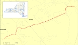
New York State Route 216 (NY 216) is a short state highway
located entirely in Dutchess County, New York
, United States
. At 6.22 miles (10.01 km) in length, it connects NY 52
and NY 55
between the hamlets of Stormville (within the town of East Fishkill
) at the east end and Poughquag (within the town of Beekman
) at the west. The route serves the hamlet of Green Haven and passes by the Green Haven Correctional Facility
.
Route 216 was originally part of NY 39 in the 1920s. The portion of NY 39 from Stormville to West Patterson was redesignated as part of NY 52 in the 1930 renumbering of state highways in New York. At the same time, an alternate route of NY 52 between Stormville and Towners was assigned the NY 216 designation. The alignments of NY 52 and NY 216 between the two locations were largely swapped ca. 1937. In 1970, Route 216 was truncated to its current eastern terminus in Poughquag.
just south of the Trump National Golf Club in Stormville, a hamlet within the town of East Fishkill
. It heads northeast into the center of Stormville and intersects with Old Route 52, a former alignment of NY 52. The route makes a sharp turn to the north before intersecting with Phillips Road and turning eastward. Proceeding east, NY 216 intersects Green Haven Road (County Route 8 or CR 8) in the hamlet of Green Haven. South of this intersection is the Green Haven Correctional Facility
. After intersecting with several local roads, it turns north and intersects Main Street (CR 7) in the Beekman
hamlet of Poughquag. South of the Beekman Cemetery, NY 216 terminates at NY 55
.
to Patterson
via East Fishkill
, Stormville and Poughquag. In the 1930 renumbering of state highways in New York, the portion of NY 39 between East Fishkill and the western fringe of Patterson was redesignated as part of the new NY 52
while the segment between Patterson and NY 22
was renumbered to NY 311
. At the same time, NY 216 was assigned to a highway extending from NY 52 in Stormville southeast to NY 52 near Towners. NY 216 followed modern NY 52 north of Ludingtonville and Ludingtonville Road south of the hamlet.
NY 52 and NY 216 largely swapped alignments ca. 1937 as part of a larger realignment of NY 52 through Dutchess
and Putnam
Counties. Route 52 was relocated onto NY 216 between Stormville and Ludingtonville, from where it followed a new roadway south to Lake Carmel
. The former alignment of NY 52 between Stormville and Towners became NY 216, which was also extended eastward along NY 164
to a new eastern terminus at NY 22
east of Towners. The alignment of NY 216 remained unaltered until January 1, 1970, when Route 216 was truncated to its current eastern terminus in Poughquag. As part of the truncation, NY 216's former alignment from West Pawling to Patterson was renumbered to NY 292
while the east–west roadway through Towners became NY 164.
State highway
State highway, state road or state route can refer to one of three related concepts, two of them related to a state or provincial government in a country that is divided into states or provinces :#A...
located entirely in Dutchess County, New York
Dutchess County, New York
Dutchess County is a county located in the U.S. state of New York, in the state's Mid-Hudson Region of the Hudson Valley. The 2010 census lists the population as 297,488...
, United States
United States
The United States of America is a federal constitutional republic comprising fifty states and a federal district...
. At 6.22 miles (10.01 km) in length, it connects NY 52
New York State Route 52
New York State Route 52 is a long state highway in the southeastern part of New York in the United States. It generally runs from west to east, beginning at the Pennsylvania state line in the Delaware River near Narrowsburg, crossing the Hudson River on the Newburgh-Beacon Bridge, and ending...
and NY 55
New York State Route 55
New York State Route 55 is a state highway in southern New York, running from the Pennsylvania state line at the Delaware River in Barryville to the Connecticut state line at Wingdale...
between the hamlets of Stormville (within the town of East Fishkill
East Fishkill, New York
East Fishkill is a town on the southern border of Dutchess County, New York, United States. The population was 25,589 at the 2000 census. The town name is derived from its formation from Fishkill, NY....
) at the east end and Poughquag (within the town of Beekman
Beekman, New York
Beekman is a town in Dutchess County, New York, United States. It is part of the Poughkeepsie–Newburgh–Middletown, NY Metropolitan Statistical Area as well as the larger New York–Newark–Bridgeport, NY-NJ-CT-PA Combined Statistical Area. The population was 11,452 at the 2000...
) at the west. The route serves the hamlet of Green Haven and passes by the Green Haven Correctional Facility
Green Haven Correctional Facility
Green Haven Correctional Facility is a maximum security prison in New York, United States. The prison is located in the Town of Beekman in Dutchess County. The New York State Department of Correctional Services lists the address as Route 216, Stormville, NY 12582...
.
Route 216 was originally part of NY 39 in the 1920s. The portion of NY 39 from Stormville to West Patterson was redesignated as part of NY 52 in the 1930 renumbering of state highways in New York. At the same time, an alternate route of NY 52 between Stormville and Towners was assigned the NY 216 designation. The alignments of NY 52 and NY 216 between the two locations were largely swapped ca. 1937. In 1970, Route 216 was truncated to its current eastern terminus in Poughquag.
Route description
NY 216's western terminus is at an intersection with NY 52New York State Route 52
New York State Route 52 is a long state highway in the southeastern part of New York in the United States. It generally runs from west to east, beginning at the Pennsylvania state line in the Delaware River near Narrowsburg, crossing the Hudson River on the Newburgh-Beacon Bridge, and ending...
just south of the Trump National Golf Club in Stormville, a hamlet within the town of East Fishkill
East Fishkill, New York
East Fishkill is a town on the southern border of Dutchess County, New York, United States. The population was 25,589 at the 2000 census. The town name is derived from its formation from Fishkill, NY....
. It heads northeast into the center of Stormville and intersects with Old Route 52, a former alignment of NY 52. The route makes a sharp turn to the north before intersecting with Phillips Road and turning eastward. Proceeding east, NY 216 intersects Green Haven Road (County Route 8 or CR 8) in the hamlet of Green Haven. South of this intersection is the Green Haven Correctional Facility
Green Haven Correctional Facility
Green Haven Correctional Facility is a maximum security prison in New York, United States. The prison is located in the Town of Beekman in Dutchess County. The New York State Department of Correctional Services lists the address as Route 216, Stormville, NY 12582...
. After intersecting with several local roads, it turns north and intersects Main Street (CR 7) in the Beekman
Beekman, New York
Beekman is a town in Dutchess County, New York, United States. It is part of the Poughkeepsie–Newburgh–Middletown, NY Metropolitan Statistical Area as well as the larger New York–Newark–Bridgeport, NY-NJ-CT-PA Combined Statistical Area. The population was 11,452 at the 2000...
hamlet of Poughquag. South of the Beekman Cemetery, NY 216 terminates at NY 55
New York State Route 55
New York State Route 55 is a state highway in southern New York, running from the Pennsylvania state line at the Delaware River in Barryville to the Connecticut state line at Wingdale...
.
History
In the mid-1920s, NY 39 was assigned to an alignment extending from PoughkeepsiePoughkeepsie (town), New York
Poughkeepsie is a town in Dutchess County, New York, United States. The population was 42,777 at the 2000 census. The name is derived from the native term, "Uppu-qui-ipis-in," which means "reed-covered hut by the water."...
to Patterson
Patterson, New York
Patterson is a town in Putnam County, New York, United States. The town is in the northeast part of the county. Interstate 84 passes through the southwest part of the town. The population was 11,306 at the 2000 census. The town is named after early farmer Matthew Paterson...
via East Fishkill
East Fishkill, New York
East Fishkill is a town on the southern border of Dutchess County, New York, United States. The population was 25,589 at the 2000 census. The town name is derived from its formation from Fishkill, NY....
, Stormville and Poughquag. In the 1930 renumbering of state highways in New York, the portion of NY 39 between East Fishkill and the western fringe of Patterson was redesignated as part of the new NY 52
New York State Route 52
New York State Route 52 is a long state highway in the southeastern part of New York in the United States. It generally runs from west to east, beginning at the Pennsylvania state line in the Delaware River near Narrowsburg, crossing the Hudson River on the Newburgh-Beacon Bridge, and ending...
while the segment between Patterson and NY 22
New York State Route 22
New York State Route 22 is a north–south state highway in eastern New York in the United States. It runs parallel to the state's eastern edge from the outskirts of New York City to a short distance south of the Canadian border. At , it is the state's longest north–south route and...
was renumbered to NY 311
New York State Route 311
New York State Route 311 is a state highway located entirely within Putnam County, New York, United States. The highway begins at NY 52 in Lake Carmel, and intersects Interstate 84 shortly thereafter...
. At the same time, NY 216 was assigned to a highway extending from NY 52 in Stormville southeast to NY 52 near Towners. NY 216 followed modern NY 52 north of Ludingtonville and Ludingtonville Road south of the hamlet.
NY 52 and NY 216 largely swapped alignments ca. 1937 as part of a larger realignment of NY 52 through Dutchess
Dutchess County, New York
Dutchess County is a county located in the U.S. state of New York, in the state's Mid-Hudson Region of the Hudson Valley. The 2010 census lists the population as 297,488...
and Putnam
Putnam County, New York
Putnam County is a county located in the U.S. state of New York, in the lower Hudson River Valley. Putnam county formed in 1812, when it detached from Dutchess County. , the population was 99,710. It is part of the New York Metropolitan Area. The county seat is the hamlet of Carmel...
Counties. Route 52 was relocated onto NY 216 between Stormville and Ludingtonville, from where it followed a new roadway south to Lake Carmel
Lake Carmel, New York
Lake Carmel is a hamlet located in the Town of Kent in Putnam County, New York. As of the 2000 census, the population was 8,663....
. The former alignment of NY 52 between Stormville and Towners became NY 216, which was also extended eastward along NY 164
New York State Route 164
New York State Route 164 is a short state highway located entirely in the town of Patterson in northeastern Putnam County, New York, United States. It is a short, two-lane back road that does not pass through any major populated areas and serves primarily as a connector between NY 311...
to a new eastern terminus at NY 22
New York State Route 22
New York State Route 22 is a north–south state highway in eastern New York in the United States. It runs parallel to the state's eastern edge from the outskirts of New York City to a short distance south of the Canadian border. At , it is the state's longest north–south route and...
east of Towners. The alignment of NY 216 remained unaltered until January 1, 1970, when Route 216 was truncated to its current eastern terminus in Poughquag. As part of the truncation, NY 216's former alignment from West Pawling to Patterson was renumbered to NY 292
New York State Route 292
New York State Route 292 is a short state highway in the Hudson Valley of New York, United States, bridging Putnam and Dutchess Counties. The southern terminus of the route is at an intersection with NY 311 in the town of Patterson, and the northern terminus is at a junction with...
while the east–west roadway through Towners became NY 164.