
New York State Route 990V
Encyclopedia
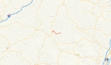
New York State Route 990V (NY 990V) is a 6.15 miles (9.9 km) long east–west reference route in Schoharie County, New York
, United States
. The western terminus of the route is at an intersection with NY 30
in Gilboa
. Its eastern terminus is at County Route 18 (CR 18) in Conesville
, where the road continues east as CR 3. NY 990V is one of four reference routes in New York that has been erroneously signed as a touring route.
NY 990V is a state-maintained remnant of New York State Route 342, a route assigned as part of the 1930 renumbering of state highways in New York. The NY 342 designation was removed in the late 1940s; however, its former routing from Gilboa to Conesville remained a state highway and became NY 990V when the modern reference route system in New York was created.
in the town of Gilboa
northwest of the Schoharie Reservoir
. The route heads northeast around the reservoir to the hamlet of Gilboa, where it crosses Schoharie Creek
a short distance downstream from the Gilboa Dam. Outside of Gilboa, NY 990V turns to the southeast and parallels the eastern edge of the reservoir into the town of Conesville
. The route remains the primary waterside roadway up to the hamlet of West Conesville, where NY 990V splits from the roadway and enters the Manor Kill Creek valley. The road continues eastward through West Conesville to the hamlet of Conesville, where it becomes CR 3 at an intersection with Champlin Road and Bear Kill Road (CR 18) near the confluence of Manor Kill Creek and the Bear Kill River.
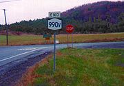 Reference routes in New York are typically not signed with touring route markers, as most are short connector roads or are known by other, more prominent names. However, NY 990V is well-signed, much in the fashion that a minor touring route would be. NY 990V is one of four reference routes in New York that is signed with touring route markers, along with NY 961F
, NY 962J
and NY 990L
.
near the hamlet of Gilboa
and ended in the Conesville
hamlet of Manorkill. By the following year, NY 342 was truncated westward to Conesville while a highway between NY 23
near South Gilboa and NY 30 southwest of Gilboa was designated as NY 297. The NY 297 designation was removed ca. 1936. NY 342 was extended westward over the former routing of NY 297 in the mid-1940s before it ceased to exist altogether in the late 1940s. While the portion west of NY 30 became CR 14, the section east of NY 30 remained state-maintained. When the modern reference route system was created, the Gilboa–Conesville state highway was designated as NY 990V.
Schoharie County, New York
As of the census of 2000, there were 31,582 people, 11,991 households and 8,177 families residing in the county. The population density was 51 people per square mile . There were 15,915 housing units at an average density of 26 per square mile...
, United States
United States
The United States of America is a federal constitutional republic comprising fifty states and a federal district...
. The western terminus of the route is at an intersection with NY 30
New York State Route 30
New York State Route 30 is a state highway in the central part of New York in the United States. It extends for from an interchange with NY 17 in the Southern Tier to the Canadian border in the state's North Country, where it continues into Quebec as Route 138. On a regional level,...
in Gilboa
Gilboa, New York
Gilboa is a town in Schoharie County, New York, United States. The population was 1,215 at the 2000 census.The Town of Gilboa is in the south part of the county and is southwest of Albany.- History :The town was first settled around 1760....
. Its eastern terminus is at County Route 18 (CR 18) in Conesville
Conesville, New York
Conesville is a town in Schoharie County, New York, United States. The population was 726 at the 2000 census. The town is named after Jonathan Cone, an early resident....
, where the road continues east as CR 3. NY 990V is one of four reference routes in New York that has been erroneously signed as a touring route.
NY 990V is a state-maintained remnant of New York State Route 342, a route assigned as part of the 1930 renumbering of state highways in New York. The NY 342 designation was removed in the late 1940s; however, its former routing from Gilboa to Conesville remained a state highway and became NY 990V when the modern reference route system in New York was created.
Route description
NY 990V begins at an intersection with NY 30New York State Route 30
New York State Route 30 is a state highway in the central part of New York in the United States. It extends for from an interchange with NY 17 in the Southern Tier to the Canadian border in the state's North Country, where it continues into Quebec as Route 138. On a regional level,...
in the town of Gilboa
Gilboa, New York
Gilboa is a town in Schoharie County, New York, United States. The population was 1,215 at the 2000 census.The Town of Gilboa is in the south part of the county and is southwest of Albany.- History :The town was first settled around 1760....
northwest of the Schoharie Reservoir
Schoharie Reservoir
The Schoharie Reservoir is a small reservoir in the Catskill Mountains of New York State that was created to be one of 19 reservoirs that supplies New York City with water. It was created by impounding Schoharie Creek...
. The route heads northeast around the reservoir to the hamlet of Gilboa, where it crosses Schoharie Creek
Schoharie Creek
Schoharie Creek in New York, USA flows north from the foot of Indian Head Mountain in the Catskill Mountains through the Schoharie Valley to the Mohawk River. It is twice impounded north of Prattsville to create New York City's Schoharie Reservoir and the Blenheim-Gilboa Power Project.Two notable...
a short distance downstream from the Gilboa Dam. Outside of Gilboa, NY 990V turns to the southeast and parallels the eastern edge of the reservoir into the town of Conesville
Conesville, New York
Conesville is a town in Schoharie County, New York, United States. The population was 726 at the 2000 census. The town is named after Jonathan Cone, an early resident....
. The route remains the primary waterside roadway up to the hamlet of West Conesville, where NY 990V splits from the roadway and enters the Manor Kill Creek valley. The road continues eastward through West Conesville to the hamlet of Conesville, where it becomes CR 3 at an intersection with Champlin Road and Bear Kill Road (CR 18) near the confluence of Manor Kill Creek and the Bear Kill River.
New York State Route 961F
New York State Route 961F is a reference route in the Southern Tier of New York in the United States. It extends for from an intersection with NY 70 east of the Steuben County village of Canaseraga to a junction with NY 36 in the Allegany County village of Arkport...
, NY 962J
New York State Route 962J
New York State Route 962J is a northeast–southwest reference route that has been erroneously signed as a touring route in Southern Tier town of Owego in Tioga County, New York...
and NY 990L
New York State Route 990L
New York State Route 990L is a reference route in Chenango County, New York, United States. The western terminus of the route is at an intersection with NY 12 in the city of Norwich. Its eastern terminus is at a junction with NY 23 in the town of Norwich...
.
History
The entirety of NY 990V was originally part of NY 342, a route assigned as part of the 1930 renumbering of state highways in New York. NY 342 began at NY 30New York State Route 30
New York State Route 30 is a state highway in the central part of New York in the United States. It extends for from an interchange with NY 17 in the Southern Tier to the Canadian border in the state's North Country, where it continues into Quebec as Route 138. On a regional level,...
near the hamlet of Gilboa
Gilboa, New York
Gilboa is a town in Schoharie County, New York, United States. The population was 1,215 at the 2000 census.The Town of Gilboa is in the south part of the county and is southwest of Albany.- History :The town was first settled around 1760....
and ended in the Conesville
Conesville, New York
Conesville is a town in Schoharie County, New York, United States. The population was 726 at the 2000 census. The town is named after Jonathan Cone, an early resident....
hamlet of Manorkill. By the following year, NY 342 was truncated westward to Conesville while a highway between NY 23
New York State Route 23
New York State Route 23 is an east–west state highway in the eastern portion New York in the United States. It extends for from an intersection with NY 26 in the Central New York town of Cincinnatus to the Massachusetts state line in the Berkshire Mountains, where it continues east as...
near South Gilboa and NY 30 southwest of Gilboa was designated as NY 297. The NY 297 designation was removed ca. 1936. NY 342 was extended westward over the former routing of NY 297 in the mid-1940s before it ceased to exist altogether in the late 1940s. While the portion west of NY 30 became CR 14, the section east of NY 30 remained state-maintained. When the modern reference route system was created, the Gilboa–Conesville state highway was designated as NY 990V.