

Cascades Rapids
Encyclopedia
North America
North America is a continent wholly within the Northern Hemisphere and almost wholly within the Western Hemisphere. It is also considered a northern subcontinent of the Americas...
's Columbia River
Columbia River
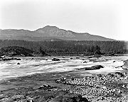
The Columbia River is the largest river in the Pacific Northwest region of North America. The river rises in the Rocky Mountains of British Columbia, Canada, flows northwest and then south into the U.S. state of Washington, then turns west to form most of the border between Washington and the state...
, between the U.S. state
U.S. state
A U.S. state is any one of the 50 federated states of the United States of America that share sovereignty with the federal government. Because of this shared sovereignty, an American is a citizen both of the federal entity and of his or her state of domicile. Four states use the official title of...
s of Washington and Oregon
Oregon
Oregon is a state in the Pacific Northwest region of the United States. It is located on the Pacific coast, with Washington to the north, California to the south, Nevada on the southeast and Idaho to the east. The Columbia and Snake rivers delineate much of Oregon's northern and eastern...
. Through a stretch approximately 150 yards (137.2 m) wide, the river dropped about 40 feet (12.2 m) in 2 miles (3.2 km).
Boat portage
Boat travelers were forced to either portagePortage
Portage or portaging refers to the practice of carrying watercraft or cargo over land to avoid river obstacles, or between two bodies of water. A place where this carrying occurs is also called a portage; a person doing the carrying is called a porter.The English word portage is derived from the...
boats and supplies or pull boats up with ropes. It is generally held that these rapids or cascades (or the many cascades along the Columbia River Gorge
Columbia River Gorge
The Columbia River Gorge is a canyon of the Columbia River in the Pacific Northwest of the United States. Up to deep, the canyon stretches for over as the river winds westward through the Cascade Range forming the boundary between the State of Washington to the north and Oregon to the south...
in this area of Oregon
Oregon
Oregon is a state in the Pacific Northwest region of the United States. It is located on the Pacific coast, with Washington to the north, California to the south, Nevada on the southeast and Idaho to the east. The Columbia and Snake rivers delineate much of Oregon's northern and eastern...
and Washington) gave rise to the name for the surrounding mountains: the Cascade Range
Cascade Range
The Cascade Range is a major mountain range of western North America, extending from southern British Columbia through Washington and Oregon to Northern California. It includes both non-volcanic mountains, such as the North Cascades, and the notable volcanoes known as the High Cascades...
.
Fishing site
The rapids were an important fishing site for Native AmericansNative Americans in the United States
Native Americans in the United States are the indigenous peoples in North America within the boundaries of the present-day continental United States, parts of Alaska, and the island state of Hawaii. They are composed of numerous, distinct tribes, states, and ethnic groups, many of which survive as...
, who would catch salmon
Salmon
Salmon is the common name for several species of fish in the family Salmonidae. Several other fish in the same family are called trout; the difference is often said to be that salmon migrate and trout are resident, but this distinction does not strictly hold true...
as they swam upriver to spawn.
Obstacle on Oregon Trail
They also posed a major obstacle to the development of the Oregon TrailOregon Trail
The Oregon Trail is a historic east-west wagon route that connected the Missouri River to valleys in Oregon and locations in between.After 1840 steam-powered riverboats and steamboats traversing up and down the Ohio, Mississippi and Missouri rivers sped settlement and development in the flat...
; initially, pioneers
American pioneer
American pioneers are any of the people in American history who migrated west to join in settling and developing new areas. The term especially refers to those who were going to settle any territory which had previously not been settled or developed by European or American society, although the...
would gather at The Dalles
The Dalles, Oregon
The Dalles is the largest city and county seat of Wasco County, Oregon, United States. The name of the city comes from the French word dalle The Dalles is the largest city and county seat of Wasco County, Oregon, United States. The name of the city comes from the French word dalle The Dalles is...
to await small boats to carry them to the Willamette Valley
Willamette Valley
The Willamette Valley is the most populated region in the state of Oregon of the United States. Located in the state's northwest, the region is surrounded by tall mountain ranges to the east, west and south and the valley's floor is broad, flat and fertile because of Ice Age conditions...
; in 1845, Sam Barlow
Sam Barlow
Samuel Kimbrough Barlow was a pioneer in the area that became the U.S. state of Oregon, and was key in establishing the Barlow Road, the most widely chosen final segment to the Oregon Trail.-Biography:...
and his associates built a road
Barlow Road
The Barlow Road is a historic road in what is now the U.S. state of Oregon. It was built in 1846 by Sam Barlow and Philip Foster, with authorization of the Provisional Legislature of Oregon, and served as the last overland segment of the Oregon Trail...
around the south side of Mount Hood
Mount Hood
Mount Hood, called Wy'east by the Multnomah tribe, is a stratovolcano in the Cascade Volcanic Arc of northern Oregon. It was formed by a subduction zone and rests in the Pacific Northwest region of the United States...
, which allowed travelers along the Trail to bypass the rapids on the last leg of their journeys.
Conflicts over portage rights
Conflicts continued thereafter between the ChinookanChinookan
Chinook refers to several native amercain groups of in the Pacific Northwest region of the United States, speaking the Chinookan languages. In the early 19th century, the Chinookan-speaking peoples lived along the lower and middle Columbia River in present-day Oregon and Washington...
natives and Europeans and Americans, who generally refused to recognize the natives' authority over passage through the area. By 1813–14, fur traders passing through were resorting to violent force against the Indians. Although more diplomatic approaches eventually prevailed, a malaria
Malaria
Malaria is a mosquito-borne infectious disease of humans and other animals caused by eukaryotic protists of the genus Plasmodium. The disease results from the multiplication of Plasmodium parasites within red blood cells, causing symptoms that typically include fever and headache, in severe cases...
outbreak in the 1830s so reduced the populations of the Cascade and other Indian tribes, that they ceased to be a powerful force along the river.
However, three forts, Fort Cascades
Fort Cascades
Fort Cascades was a United States Army fort constructed in 1855 to protect the portage road around the final section of the Cascades Rapids, known as the "lower cascades." It was built on the Washington side of the Columbia River, between the present site of North Bonneville and the Bonneville...
, Fort Raines
Fort Raines
Fort Raines was a United States Army blockhouse built in October 1855 to protect the portage road around the Cascades Rapids. It is located on the Washington side of the Columbia River, west of the Bridge of the Gods, at the "middle cascades." It was abandoned by 1857...
and Fort Lugenbeel were constructed between present day Stevenson, Washington
Stevenson, Washington
Stevenson is a town in Skamania County, Washington, United States. The population was 1,465 at the 2010 census, a 22% increase over 2000. It is the county seat of Skamania County and home to the Skamania County Court House and Sheriff's Office...
and North Bonneville
North Bonneville, Washington
North Bonneville is a city in Skamania County, Washington, United States. The population was 593 at the 2000 census and 956 at the 2010 census.-Geography:North Bonneville is located at ....
over 1855–6 to protect the portage road around the rapids. Natives burned Fort Cascades in 1856, but it was rebuilt. This attack prompted the construction of Fort Lugenbeel.
Steamboat navigation
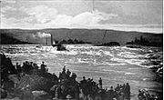
Cascade Locks, Oregon
Cascade Locks is a city in Hood River County, Oregon, United States. The city took its name from a set of locks built to improve navigation past the Cascades Rapids of the Columbia River. The U.S. federal government approved the plan for the locks in 1875, construction began in 1878, and the locks...
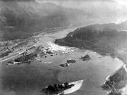
. But by 1938 the rapids were gone, submerged under the Bonneville Reservoir as it formed behind Bonneville Dam
Bonneville Dam
Bonneville Lock and Dam consists of several run-of-the-river dam structures that together complete a span of the Columbia River between the U.S. states of Oregon and Washington at River Mile 146.1. The dam is located east of Portland, Oregon, in the Columbia River Gorge. The primary functions of...
. Bonneville Lock at the dam, completed in 1937, replaced the old Cascade Locks around the rapids.
See also
- Bridge of the Gods, a land bridge formed by the Bonneville Slide several hundred years ago
- Bridge River RapidsBridge River RapidsThe Bridge River Rapids, also known as the Six Mile Rapids, the Lower Fountain, the Bridge River Fishing Grounds, and in the St'at'imcets language as Sat or Setl, is a set of rapids on the Fraser River, located in the central Fraser Canyon at the mouth of the Bridge River six miles north of the...
, a similar fishing site on the Fraser River - Cascade Locks and CanalCascade Locks and CanalThe Cascade Locks and Canal was a navigation project on the Columbia River between the U.S. states of Oregon and Washington, completed in 1896. It allowed the steamboats of the Columbia River to bypass the Cascades Rapids, and thereby opened a passage from the lower parts of the river as far as The...
, the first navigation locks built around the rapids, before the construction of Bonneville Dam - Celilo FallsCelilo FallsCelilo Falls was a tribal fishing area on the Columbia River, just east of the Cascade Mountains, on what is today the border between the U.S. states of Oregon and Washington...
, a more significant former fishing site and economic hub upstream of the gorge - Fort CascadesFort CascadesFort Cascades was a United States Army fort constructed in 1855 to protect the portage road around the final section of the Cascades Rapids, known as the "lower cascades." It was built on the Washington side of the Columbia River, between the present site of North Bonneville and the Bonneville...
- Greenleaf PeakGreenleaf PeakGreenleaf Peak is a mountain in the Cascade Range in the U.S. state of Washington, located on the north side of the Columbia River near Table Mountain, in the Columbia River Gorge. The peak lies within the Columbia River Gorge National Scenic Area near Bonneville Dam. It is in elevation...
- Kettle FallsKettle FallsKettle Falls was an ancient and important salmon fishing site on the upper reaches of the Columbia River, in what is today the U.S. state of Washington, near the Canadian border...
, another in Washington - Priest RapidsPriest RapidsPriest Rapids was a narrow, fast-flowing stretch of the Columbia River, located in the central region of the U.S. state of Washington. It was flooded by the construction of the Priest Rapids Dam in the 1950s....
, another fishing site in eastern Washington - Table Mountain