

North Otago
Encyclopedia
New Zealand
New Zealand is an island country in the south-western Pacific Ocean comprising two main landmasses and numerous smaller islands. The country is situated some east of Australia across the Tasman Sea, and roughly south of the Pacific island nations of New Caledonia, Fiji, and Tonga...
covers the area of Otago
Otago
Otago is a region of New Zealand in the south of the South Island. The region covers an area of approximately making it the country's second largest region. The population of Otago is...
between Shag Point and the Waitaki River
Waitaki River
The Waitaki River is a large river in the South Island of New Zealand, some 110 km long. It is the major river of the Mackenzie Basin.It is a braided river which flows through Lake Benmore, Lake Aviemore and Lake Waitaki. These are ultimately fed by three large glacial lakes, Pukaki, Tekapo,...
, and extends inland to the west as far as the village of Omarama
Omarama
Omarama is a small township at the junction of State Highways 8 and 83, near the southern end of the Mackenzie Basin, in the South Island of New Zealand. Omarama is in the Waitaki District, in the historic Province of Otago...
(which has experienced rapid growth as a developing centre for astronomy
Astronomy
Astronomy is a natural science that deals with the study of celestial objects and phenomena that originate outside the atmosphere of Earth...
and for gliding
Gliding
Gliding is a recreational activity and competitive air sport in which pilots fly unpowered aircraft known as gliders or sailplanes using naturally occurring currents of rising air in the atmosphere to remain airborne. The word soaring is also used for the sport.Gliding as a sport began in the 1920s...
). The large east-coast town of Oamaru
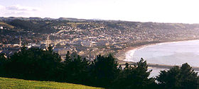
Oamaru
Oamaru , the largest town in North Otago, in the South Island of New Zealand, is the main town in the Waitaki District. It is 80 kilometres south of Timaru and 120 kilometres north of Dunedin, on the Pacific coast, and State Highway 1 and the railway Main South Line connects it to both...
serves as North Otago's main centre. The Kakanui Mountains form the principal cordillera. Prominent rivers include the Shag
Shag River
Shag River is located in Otago in the South Island of New Zealand. It rises in the Kakanui Range, flowing southeast for 50 kilometres before reaching the Pacific Ocean near the town of Palmerston...
, the Waianakarua, the Kakanui
Kakanui River
The Kakanui River is a river of North Otago, New Zealand, bridged by Highway 1 at Maheno and flowing into the Pacific Ocean at Kakanui.-References:...
and the Waitaki
Waitaki River
The Waitaki River is a large river in the South Island of New Zealand, some 110 km long. It is the major river of the Mackenzie Basin.It is a braided river which flows through Lake Benmore, Lake Aviemore and Lake Waitaki. These are ultimately fed by three large glacial lakes, Pukaki, Tekapo,...
.
Other towns and settlements in the region include Alma, Maheno
Maheno, New Zealand
Maheno is a small North Otago township south of Oamaru in New Zealand. The area has 3705 residents, making it the third most populated area in North Otago, behind Oamaru and Oamaru North...
, Kakanui
Kakanui
The small town of Kakanui lies on the coast of Otago, in New Zealand, fourteen kilometres to the south of Oamaru. The Kakanui River and its estuary divide the township in two. The part of the settlement south of the river, also known as Kakanui South, formerly "Campbells Bay", was developed as a...
, Herbert
Herbert, New Zealand
The small town of Herbert lies in North Otago, New Zealand, almost 100 kilometres to the north of Dunedin and 22 kilometres to the south of Oamaru. It lies on the edge of the Herbert Forest....
(also known as Otepopo), Waianakarua, Hampden
Hampden, New Zealand
Hampden is a rural settlement defined as a "populated area less than a town" in North Otago, New Zealand. It is located close to the North Otago coast, some 30 kilometres south of Oamaru, and 50 minutes north of Otago's largest city, Dunedin. It was named after the English politician John Hampden...
, and Moeraki
Moeraki
Moeraki is a small fishing village on the east coast of the South Island of New Zealand. It was once the location of a whaling station. In the 1870s, local interests believed it could become the main port for the north Otago area and a railway line, the Moeraki Branch, was built to the settlement...
, all close to the coast south of Oamaru.
The coastal plain north of Oamaru has the settlements of Hilderthorpe and Pukeuri.
Inland we find Weston
Weston, New Zealand
Weston is a township situated inland from Oamaru, South Island, New Zealand. It is regarded as one of the more affluent townships of the Waitaki District and had a population of 730 in the 2006 census....
, Ardgowan, Windsor
Windsor, New Zealand
Windsor is a township in North Otago, inland from Oamaru, situated almost exactly on the 45th latitude.The township was surveyed in 1879 and sold by Edward Menlove, the owner of the Windsor Park Estate. It was situated at the junction of the Ngapara and Tokarahi branch railway lines.The Tokarahi...
, Five Forks, Peebles, Papakaio, Duntroon
Duntroon, New Zealand
Duntroon is a small farming town in the Waitaki District of New Zealand's South Island. Although traditionally considered a North Otago town, it is presently officially located within the farthest southern reaches of Canterbury...
, Kurow
Kurow
Kurow is a town in the Waitaki Valley in the South Island of New Zealand, 55 kilometres inland from OamaruThe name of the town is an Anglicised form of the name of the nearby mountain Te Kohurau....
(on the south bank of the Waitaki), Omarama
Omarama
Omarama is a small township at the junction of State Highways 8 and 83, near the southern end of the Mackenzie Basin, in the South Island of New Zealand. Omarama is in the Waitaki District, in the historic Province of Otago...
, and Otematata.
The area aspired to provincial
Provinces of New Zealand
The Provinces of New Zealand existed from 1841 until 1876 as a form of sub-national government. They were replaced by counties, which were themselves replaced by districts.Following abolition, the provinces became known as provincial districts...
status in the 19th century, but never attained this. Most of its territory belonged to the Waitaki County, and today is officially part of the Waitaki District
Waitaki District
The Waitaki district, in the Canterbury and Otago regions of New Zealand, straddles the traditional border between the two regions, the Waitaki River. It has a land area of 7,151.94 km² , divided 59.28% to Canterbury Region and 40.72% to Otago Region. It is the only district on the South...
. Some sense of regional identity survives in support of sport, notably the North Otago rugby team. In recent years the northwestern part of the area, including the towns of Omarama, Otematata, Kurow, and Duntroon have officially become part of Canterbury Region
Canterbury, New Zealand
The New Zealand region of Canterbury is mainly composed of the Canterbury Plains and the surrounding mountains. Its main city, Christchurch, hosts the main office of the Christchurch City Council, the Canterbury Regional Council - called Environment Canterbury - and the University of Canterbury.-...
, testing this sense of identity.
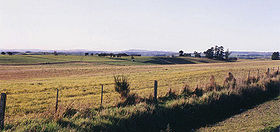
The rolling, tussock-clad hill country of North Otago provides the important agricultural base, particularly through sheep-farming. The generation of hydro-electricity in the Waitaki Valley has also drawn attention to the area (see Project Aqua
Project Aqua
Project Aqua is an abandoned hydroelectric scheme once proposed for the lower Waitaki River in New Zealand. Although the scheme had considerable support from some locals, it met with considerable opposition from others, and Meridian Energy decided in March 2004 not to go ahead with the project.The...
), and tourism has grown in recent years.