

Ohio State Route 741
Encyclopedia
State highway
State highway, state road or state route can refer to one of three related concepts, two of them related to a state or provincial government in a country that is divided into states or provinces :#A...
in the southwest portion of the U.S. state
U.S. state
A U.S. state is any one of the 50 federated states of the United States of America that share sovereignty with the federal government. Because of this shared sovereignty, an American is a citizen both of the federal entity and of his or her state of domicile. Four states use the official title of...
of Ohio
Ohio
Ohio is a Midwestern state in the United States. The 34th largest state by area in the U.S.,it is the 7th‑most populous with over 11.5 million residents, containing several major American cities and seven metropolitan areas with populations of 500,000 or more.The state's capital is Columbus...
. The southern terminus of the route is at a diamond interchange with I-71 at its Exit 25 near Kings Mills
Kings Mills, Ohio
Kings Mills is an unincorporated community in the northeastern corner of Deerfield Township, Warren County, Ohio, United States, on the western shore of the Little Miami River...
, adjacent to the Kings Island
Kings Island
Kings Island is a amusement park located northeast of Cincinnati in Mason, Ohio. Opened in 1972 by Taft Broadcasting Company and now owned by Cedar Fair Entertainment Company, Kings Island is the most visited seasonal amusement park in the U.S...
Amusement Park. State Route 741’s northern terminus is at a partial interchange with I-75 at its Exit 50B in Moraine
Moraine, Ohio
Moraine is a city in Montgomery County, Ohio, United States. The population was 6,307 at the 2010 census. The city is part of the The Dayton Metropolitan Statistical Area, which includes Montgomery county. Moraine, as part of the Dayton area, is situated within the Miami Valley region of Ohio, just...
, just south of Dayton
Dayton, Ohio
Dayton is the 6th largest city in the U.S. state of Ohio and the county seat of Montgomery County, the fifth most populous county in the state. The population was 141,527 at the 2010 census. The Dayton Metropolitan Statistical Area had a population of 841,502 in the 2010 census...
.
Created in the late 1930s, State Route 741 passes through the counties of Warren
Warren County, Ohio
Warren County is a county located in the state of Ohio, United States. The population was 212,693 at the 2010 census. Its county seat is Lebanon. Warren County was erected May 1, 1803, from Hamilton County, and named for Dr...
and Montgomery
Montgomery County, Ohio
Montgomery County is a county located in the state of Ohio, United States. The population was 535,153 in the 2010 Census. It was named in honor of Richard Montgomery, an American Revolutionary War general killed in 1775 while attempting to capture Quebec City, Canada. The county seat is Dayton...
. The portion of State Route 741 in Montgomery County is also called Springboro Pike.
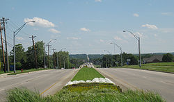
Route description
State Route 741's routing takes it through WarrenWarren County, Ohio
Warren County is a county located in the state of Ohio, United States. The population was 212,693 at the 2010 census. Its county seat is Lebanon. Warren County was erected May 1, 1803, from Hamilton County, and named for Dr...
and Montgomery
Montgomery County, Ohio
Montgomery County is a county located in the state of Ohio, United States. The population was 535,153 in the 2010 Census. It was named in honor of Richard Montgomery, an American Revolutionary War general killed in 1775 while attempting to capture Quebec City, Canada. The county seat is Dayton...
Counties. No portion of the state route is included within the National Highway System
National Highway System (United States)
The National Highway System is a network of strategic highways within the United States, including the Interstate Highway System and other roads serving major airports, ports, rail or truck terminals, railway stations, pipeline terminals and other strategic transport facilities.Individual states...
, a system of routes deemed most important for the nation's economy, mobility and defense.
History
When it was formed in 1938, State Route 741 was originally routed from its junction with U.S. Route 42 near MasonMason, Ohio
Mason is an affluent city in southwestern Warren County, Ohio, United States, 22 miles away from Cincinnati . As of the 2010 census, Mason's population was 30,712. Mason has experienced fast growth, with its historic Main Street remaining at the center of the community...
to its intersection with the former U.S. Route 25
U.S. Route 25
U.S. Route 25 is a north–south United States highway that runs for from Brunswick, Georgia to the Ohio state line in Covington, Kentucky.-Georgia:...
(now Dixie Drive) near West Carrollton
West Carrollton, Ohio
West Carrollton is a city in Montgomery County, Ohio, United States. The population was 13,143 at the 2010 census. It is part of the Dayton Metropolitan Statistical Area....
. By 1971, State Route 741 was extended north along Springboro Pike from Dixie Drive up to its current northern terminus at Interstate 75 in Moraine
Moraine, Ohio
Moraine is a city in Montgomery County, Ohio, United States. The population was 6,307 at the 2010 census. The city is part of the The Dayton Metropolitan Statistical Area, which includes Montgomery county. Moraine, as part of the Dayton area, is situated within the Miami Valley region of Ohio, just...
. In 1985, the highway would be lengthened again, this time on the south end. From U.S. Route 42, State Route 741 was extended south and east to Exit 25 off of I-71 near Kings Mills
Kings Mills, Ohio
Kings Mills is an unincorporated community in the northeastern corner of Deerfield Township, Warren County, Ohio, United States, on the western shore of the Little Miami River...
, which marks the route's present-day southern terminus.