
Monadnock-Sunapee Greenway
Encyclopedia
The Monadnock-Sunapee Greenway (MSG) is a 50 miles (80.5 km) hiking
Hiking
Hiking is an outdoor activity which consists of walking in natural environments, often in mountainous or other scenic terrain. People often hike on hiking trails. It is such a popular activity that there are numerous hiking organizations worldwide. The health benefits of different types of hiking...
trail that traverses the highlands of southern New Hampshire
New Hampshire
New Hampshire is a state in the New England region of the northeastern United States of America. The state was named after the southern English county of Hampshire. It is bordered by Massachusetts to the south, Vermont to the west, Maine and the Atlantic Ocean to the east, and the Canadian...
from Mount Monadnock
Mount Monadnock
Mount Monadnock, or Grand Monadnock, is the most prominent New England mountain peak south of the White Mountains and east of the Massachusetts Berkshires, and is the highest point in Cheshire County, New Hampshire...
in Jaffrey
Jaffrey, New Hampshire
Jaffrey is a town in Cheshire County, New Hampshire, United States. The population was 5,457 at the 2010 census.The primary settlement in town, where 2,757 people resided at the 2010 census, is defined as the Jaffrey census-designated place and is located along the Contoocook River at the...
to Mount Sunapee
Mount Sunapee
Mount Sunapee is a -long mountain ridge in the towns of Newbury and Goshen in western New Hampshire. Its highest peak, at the north end of the mountain, is above sea level. The mountain has three secondary peaks, White Ledges at ; North Peak at ; and South Peak at...
in Newbury
Newbury, New Hampshire
Newbury is a town in Merrimack County, New Hampshire, United States. The population was 2,072 at the 2010 census. Newbury is home to part of Lake Sunapee, including Mount Sunapee State Park Beach. Mount Sunapee Resort, a ski area in Mount Sunapee State Park, is in the west...
. Located approximately 27 miles (43.5 km) from the city of Concord, New Hampshire
Concord, New Hampshire
The city of Concord is the capital of the state of New Hampshire in the United States. It is also the county seat of Merrimack County. As of the 2010 census, its population was 42,695....
, the trail traverses a rural, heavily glaciated and metamorphic
Metamorphic rock
Metamorphic rock is the transformation of an existing rock type, the protolith, in a process called metamorphism, which means "change in form". The protolith is subjected to heat and pressure causing profound physical and/or chemical change...
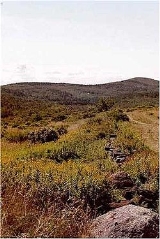
upland studded with lakes, heath barrens
Heath (habitat)
A heath or heathland is a dwarf-shrub habitat found on mainly low quality acidic soils, characterised by open, low growing woody vegetation, often dominated by plants of the Ericaceae. There are some clear differences between heath and moorland...
, the rocky summits of several monadnock
Monadnock
A monadnock or inselberg is an isolated rock hill, knob, ridge, or small mountain that rises abruptly from a gently sloping or virtually level surrounding plain...
s, and dense woodland of the northern hardwood forest
Northern hardwood forest
The northern hardwood forest is a general type of North American forest ecosystem found over much of southeastern and south central Canada, extending south into the United States in northern New England and New York, and west along the Great Lakes to Minnesota and western Ontario...
type. The trail is maintained primarily through the efforts of the Monadnock-Sunapee Greenway Trail Club.
Notable features along the route include the summit of Mount Monadnock; Eliza Adams Gorge; the classic New England town commons of Nelson
Nelson, New Hampshire
Nelson is a town in Cheshire County, New Hampshire, United States. The population was 729 at the 2010 census. Nelson includes the village of Munsonville.-History:...
and Washington
Washington, New Hampshire
Washington is a town in Sullivan County, New Hampshire, United States. The population was 1,123 at the 2010 census. Situated in a hilly, rocky, forested area, and with 26 lakes and ponds, Washington is a picturesque resort area...
; the New Hampshire Audubon Society's Nye Meadow Refuge; Otter Brook and Andorra Forest; the high heath barrens of Pitcher Mountain
Pitcher Mountain
Pitcher Mountain is a 2,153 feet monadnock located in southwest New Hampshire. The mountain is traversed by the 50 mile Monadnock-Sunapee Greenway and offers 360 degree views from its open summit. Lower elevations are wooded with species of the northern hardwood forest type; small stands of...
, Hubbard Hill, and Jackson Hill; Lovewell Mountain
Lovewell Mountain
Lovewell Mountain is a 2,473 feet monadnock associated with the Sunapee Ridge in southwest New Hampshire. The mountain is traversed by the 50 mile Monadnock-Sunapee Greenway and offers vistas from several ledges near its summit...
; 8 miles (12.9 km) of the Sunapee Ridge; and Lake Solitude
Lake Solitude (New Hampshire)
Lake Solitude, , is a highland tarn located at the top of Sunapee Ridge between the main summit of Mount Sunapee and South Peak. The lake, 4.61 acres , is approximately long by wide and is located within Newbury, New Hampshire and Mount Sunapee State Park. A popular hiking destination, Lake...
, a mountaintop tarn
Tarn (lake)
A tarn is a mountain lake or pool, formed in a cirque excavated by a glacier. A moraine may form a natural dam below a tarn. A corrie may be called a cirque.The word is derived from the Old Norse word tjörn meaning pond...
near the summit of Mount Sunapee. A number of lakes, reservoirs, ponds, and other wetlands are also located along the route.
Trail description

Cheshire County, New Hampshire
-Demographics:As of the census of 2000, there were 73,825 people, 28,299 households, and 18,790 families residing in the county. The population density was 104 people per square mile . There were 31,876 housing units at an average density of 45 per square mile...
, Sullivan County
Sullivan County, New Hampshire
-Demographics:As of the census of 2000, there were 40,458 people, 16,530 households, and 11,174 families residing in the county. The population density was 29/; . There were 20,158 housing units at an average density of 38 per square mile...
, and Merrimack County
Merrimack County, New Hampshire
-Demographics:As of the census of 2000, there were 136,225 people, 51,843 households, and 35,460 families residing in the county. The population density was 146 people per square mile . There were 56,244 housing units at an average density of 60 per square mile...
. The MSG passes through the following incorporated communities: Jaffrey
Jaffrey, New Hampshire
Jaffrey is a town in Cheshire County, New Hampshire, United States. The population was 5,457 at the 2010 census.The primary settlement in town, where 2,757 people resided at the 2010 census, is defined as the Jaffrey census-designated place and is located along the Contoocook River at the...
, Dublin
Dublin, New Hampshire
Dublin is a town in Cheshire County, New Hampshire, United States. The population was 1,597 at the 2010 census. It is home to both the Dublin School and Yankee Magazine.-History:...
, Harrisville
Harrisville, New Hampshire
Harrisville is a town in Cheshire County, New Hampshire, United States. Besides the town center, it also includes the village of Chesham. The population of the town was 961 at the 2010 census....
, Nelson
Nelson, New Hampshire
Nelson is a town in Cheshire County, New Hampshire, United States. The population was 729 at the 2010 census. Nelson includes the village of Munsonville.-History:...
, Stoddard
Stoddard, New Hampshire
Stoddard is a town in Cheshire County, New Hampshire, United States. The population was 1,232 at the 2010 census.Between 1842 and 1873, the town was home to four glass manufacturers. The glass produced by these works, now known as Stoddard glass, is noted for its deep amber colors and design...
, Washington
Washington, New Hampshire
Washington is a town in Sullivan County, New Hampshire, United States. The population was 1,123 at the 2010 census. Situated in a hilly, rocky, forested area, and with 26 lakes and ponds, Washington is a picturesque resort area...
, Goshen
Goshen, New Hampshire
Goshen is a town in Sullivan County, New Hampshire, United States. The population was 810 at the 2010 census.- History :Incorporated in 1791, Goshen was first settled in 1768 as a part of Saville...
, and Newbury, New Hampshire
Newbury, New Hampshire
Newbury is a town in Merrimack County, New Hampshire, United States. The population was 2,072 at the 2010 census. Newbury is home to part of Lake Sunapee, including Mount Sunapee State Park Beach. Mount Sunapee Resort, a ski area in Mount Sunapee State Park, is in the west...
.
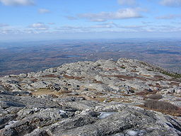
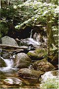
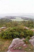
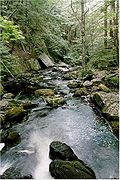
Mount Monadnock, the southern terminus of the MSG, is the most prominent peak of southeast New England. At 3165 feet (964.7 m) high, it is 1000 feet (304.8 m) higher than any mountain peak within 30 miles (48.3 km) and rises 2000 feet (609.6 m) above the surrounding landscape. Its bare, rocky summit provides expansive views. Eliza Adams Gorge is a scenic and rocky eastern hemlock
Eastern Hemlock
Tsuga canadensis, also known as eastern or Canadian hemlock, and in the French-speaking regions of Canada as pruche du Canada, is a coniferous tree native to eastern North America. It ranges from northeastern Minnesota eastward through southern Quebec to Nova Scotia, and south in the Appalachian...
-clad ravine located just below the dam spillway on Howe Reservoir. The Nye Meadow Refuge is an important great blue heron
Great Blue Heron
The Great Blue Heron is a large wading bird in the heron family Ardeidae, common near the shores of open water and in wetlands over most of North and Central America as well as the West Indies and the Galápagos Islands. It is a rare vagrant to Europe, with records from Spain, the Azores and England...
rookery managed by the Audubon Society of New Hampshire. Otter Brook and Andorra Forest, 15000 acres (60.7 km²), collectively the largest conservation area in southwest New Hampshire, are cooperatively managed by The Nature Conservancy
The Nature Conservancy
The Nature Conservancy is a US charitable environmental organization that works to preserve the plants, animals, and natural communities that represent the diversity of life on Earth by protecting the lands and waters they need to survive....
and the Society for the Protection of New Hampshire Forests
Society for the Protection of New Hampshire Forests
The Society for the Protection of New Hampshire Forests is a private, non-profit land-conservation organization based in the U.S. state of New Hampshire. It purchases or is given easements or outright ownership of undeveloped land, as a way to keep it open, and also performs advocacy and education...
and include extensive tracts of northern hardwood forest
Northern hardwood forest
The northern hardwood forest is a general type of North American forest ecosystem found over much of southeastern and south central Canada, extending south into the United States in northern New England and New York, and west along the Great Lakes to Minnesota and western Ontario...
, wetlands, and rare plant communities. Pitcher Mountain, 2153 feet (656.2 m), Hubbard Hill, 1846 feet (562.7 m), and Jackson Hill, 2061 feet (628.2 m), offer wide views from upland heath barrens and blueberry
Blueberry
Blueberries are flowering plants of the genus Vaccinium with dark-blue berries and are perennial...
fields.
Lovewell Mountain, 2473 feet (753.8 m), is a rugged monadnock contiguous with the southern part of Sunapee Ridge; several scenic outlooks on ledges provide views of the surrounding countryside. Mount Sunapee, 2743 feet (836.1 m), is the high point of a mountainous 10 miles (16.1 km) ridgeline that spans four towns. The ridge offers scenic vistas from more than a dozen distinct peaks along its length and from the Mount Sunapee ski area
Mount Sunapee Resort
-History:Mount Sunapee's history as a ski area dates back to as early as 1940, when in response to the success of a tram at Cannon Mountain a survey was made for a similar tram on Mount Sunapee. The following year, the state of New Hampshire passed the Mt...
on the summit. Other notable peaks along its length include White Ledges, 2700 feet (823 m), which overlooks Lake Solitude; Lucia's Lookout, 2500 feet (762 m); an unnamed southern summit, 2230 feet (679.7 m); and Kittredge Hill, 2140 feet (652.3 m). The commons of Washington and Nelson are small and bucolic classic New England town centers with little commercial development and with architecture dating back to the early 19th century. Washington, 1507 feet (459.3 m), is the highest incorporated town in New Hampshire; it is 1 foot (0.3048 m) higher than the next-highest town, the ski resort community of Waterville Valley
Waterville Valley, New Hampshire
Waterville Valley is a town in Grafton County, New Hampshire, United States. The population was 247 at the 2010 census.Waterville Valley attracts many visitors in the winter months with alpine skiing at Waterville Valley Resort and many miles of trails for cross-country skiing. During the summer,...
Notable bodies of water along the trail route include Seavers Reservoir, Howe Reservoir, Chesham Pond, Silver Lake
Silver Lake (Harrisville, New Hampshire)
Silver Lake is a water body located in Cheshire County in southwestern New Hampshire, in the towns of Harrisville and Nelson. Water from Silver Lake flows via Minnewawa Brook and The Branch to the Ashuelot River, a tributary of the Connecticut River....
, Childs Bog, Center Pond, Halfmoon Pond, and the mountaintop Lake Solitude.
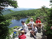
The MSG is primarily used for hiking
Hiking
Hiking is an outdoor activity which consists of walking in natural environments, often in mountainous or other scenic terrain. People often hike on hiking trails. It is such a popular activity that there are numerous hiking organizations worldwide. The health benefits of different types of hiking...
, backpacking
Backpacking (wilderness)
Backpacking combines the activities of hiking and camping for an overnight stay in backcountry wilderness...
, and in the winter, snowshoe
Snowshoe
A snowshoe is footwear for walking over the snow. Snowshoes work by distributing the weight of the person over a larger area so that the person's foot does not sink completely into the snow, a quality called "flotation"....
ing. Portions of the trail are suitable for, and are used for, backcountry skiing
Backcountry skiing
Backcountry skiing is skiing in a sparsely inhabited rural region over ungroomed and unmarked slopes or pistes, including skiing in unmarked or unpatrolled areas either within the ski resort's boundaries or in the backcountry, frequently amongst trees , usually in pursuit of fresh fallen powder...
. Site-specific activities enjoyed along the route include hunting
Hunting
Hunting is the practice of pursuing any living thing, usually wildlife, for food, recreation, or trade. In present-day use, the term refers to lawful hunting, as distinguished from poaching, which is the killing, trapping or capture of the hunted species contrary to applicable law...
, fishing
Fishing
Fishing is the activity of trying to catch wild fish. Fish are normally caught in the wild. Techniques for catching fish include hand gathering, spearing, netting, angling and trapping....
, boating
Boating
Boating is the leisurely activity of travelling by boat, or the recreational use of a boat whether powerboats, sailboats, or man-powered vessels , focused on the travel itself, as well as sports activities, such as fishing or water skiing...
, and swimming.
Intersecting trails
Metacomet-Monadnock Trail
The Metacomet-Monadnock Trail is a hiking trail that traverses the Metacomet Ridge of the Pioneer Valley region of Massachusetts and the central uplands of Massachusetts and southern New Hampshire...
in southern New Hampshire and central Massachusetts
Massachusetts
The Commonwealth of Massachusetts is a state in the New England region of the northeastern United States of America. It is bordered by Rhode Island and Connecticut to the south, New York to the west, and Vermont and New Hampshire to the north; at its east lies the Atlantic Ocean. As of the 2010...
continues south where the MSGT leaves off. This extends the overall hiking possibilities another 210 miles (338 km) via the Metacomet-Monadnock Trail and its logical extensions, the Metacomet
Metacomet Trail
The Metacomet Trail is a Blue-Blazed hiking trail that traverses the Metacomet Ridge of central Connecticut and is a part of the newly designated New England National Scenic Trail. Despite being easily accessible and close to large population centers, the trail is considered remarkably rugged and...
and Mattabesett Trail
Mattabesett Trail
The Mattabesett Trail is a long, hook-shaped Blue-Blazed hiking trail in central Connecticut and a part of the newly designated New England National Scenic Trail. One half of the trail follows the high traprock ridges of the Metacomet Ridge, from Totoket Mountain in Guilford, Connecticut to...
s in Connecticut
Connecticut
Connecticut is a state in the New England region of the northeastern United States. It is bordered by Rhode Island to the east, Massachusetts to the north, and the state of New York to the west and the south .Connecticut is named for the Connecticut River, the major U.S. river that approximately...
. To the north, the Sunapee-Ragged-Kearsarge Greenway Trail continues from the northern terminus of the MSG via a 75 miles (120.7 km) loop trail to Mount Kearsarge, Ragged Mountain
Ragged Mountain (New Hampshire)
Ragged Mountain is a low mountain with numerous knobby summits in the towns of Danbury and Andover in central New Hampshire. It is home to the Ragged Mountain ski resort.-Geography:In his book, The History of the Town of Andover, John R...
, Bog Mountain and back to Mount Sunapee.
History
The MSG was first suggested by Allen Chamberlain, president of the Appalachian Mountain ClubAppalachian Mountain Club
The Appalachian Mountain Club is one of the United States' oldest outdoor groups. Created in 1876 to explore and preserve the White Mountains in New Hampshire, it has expanded throughout the northeastern U.S., with 12 chapters stretching from Maine to Washington, D.C...
, in 1919 and was laid out in 1921 by the Society for the Protection of New Hampshire Forests
Society for the Protection of New Hampshire Forests
The Society for the Protection of New Hampshire Forests is a private, non-profit land-conservation organization based in the U.S. state of New Hampshire. It purchases or is given easements or outright ownership of undeveloped land, as a way to keep it open, and also performs advocacy and education...
(SPNHF). But the hurricane of 1938
New England Hurricane of 1938
The New England Hurricane of 1938 was the first major hurricane to strike New England since 1869...
and World War II
World War II
World War II, or the Second World War , was a global conflict lasting from 1939 to 1945, involving most of the world's nations—including all of the great powers—eventually forming two opposing military alliances: the Allies and the Axis...
"effectively ended the original trail; it was not maintained again." The trail was re-established after a study by the SPNHF in 1974.
Hiking the trail
Topographic map
A topographic map is a type of map characterized by large-scale detail and quantitative representation of relief, usually using contour lines in modern mapping, but historically using a variety of methods. Traditional definitions require a topographic map to show both natural and man-made features...
s is published by the Monadnock-Sunapee Greenway Trail Club.
New Hampshire
New Hampshire is a state in the New England region of the northeastern United States of America. The state was named after the southern English county of Hampshire. It is bordered by Massachusetts to the south, Vermont to the west, Maine and the Atlantic Ocean to the east, and the Canadian...
. Conditions on exposed hill tops and summits may be harsher during cold or stormy weather. Weather atop the exposed and isolated 3100 feet (944.9 m) summit of Mount Monadnock can be much more severe than conditions below; high winds are common year round and winter storms on the summit can be life-threatening. Lightning
Lightning
Lightning is an atmospheric electrostatic discharge accompanied by thunder, which typically occurs during thunderstorms, and sometimes during volcanic eruptions or dust storms...
is a hazard on exposed peaks and ledges during thunderstorms. Snow is common in the winter and may necessitate the use of cross country skis or snowshoes. Ice can form on exposed ledges and summits, making hiking dangerous without special equipment. Snow and ice tend to linger on Mount Monadnock well into the spring.
Biting insects can be bothersome during warm weather. Parasitic deer tick
Deer Tick
Deer Tick is an American indie folk band from Providence, Rhode Island led by guitarist and singer-songwriter John McCauley. Deer Tick's music has been described as a combination of folk, blues, and country.-History:...
s (which are known to carry Lyme disease
Lyme disease
Lyme disease, or Lyme borreliosis, is an emerging infectious disease caused by at least three species of bacteria belonging to the genus Borrelia. Borrelia burgdorferi sensu stricto is the main cause of Lyme disease in the United States, whereas Borrelia afzelii and Borrelia garinii cause most...
) are a potential hazard. The trail passes through black bear
American black bear
The American black bear is a medium-sized bear native to North America. It is the continent's smallest and most common bear species. Black bears are omnivores, with their diets varying greatly depending on season and location. They typically live in largely forested areas, but do leave forests in...
habitat, although problems with bears are rare. More likely are problem encounters with domestic dogs. Skunk
Skunk
Skunks are mammals best known for their ability to secrete a liquid with a strong, foul odor. General appearance varies from species to species, from black-and-white to brown or cream colored. Skunks belong to the family Mephitidae and to the order Carnivora...
s, raccoon
Raccoon
Procyon is a genus of nocturnal mammals, comprising three species commonly known as raccoons, in the family Procyonidae. The most familiar species, the common raccoon , is often known simply as "the" raccoon, as the two other raccoon species in the genus are native only to the tropics and are...
s, and porcupine
Porcupine
Porcupines are rodents with a coat of sharp spines, or quills, that defend or camouflage them from predators. They are indigenous to the Americas, southern Asia, and Africa. Porcupines are the third largest of the rodents, behind the capybara and the beaver. Most porcupines are about long, with...
s are common and active after dark. Poisonous snakes are considered extinct along the route. Poison ivy
Poison ivy
Toxicodendron radicans, better known as poison ivy , is a poisonous North American plant that is well known for its production of urushiol, a clear liquid compound found within the sap of the plant that causes an itching rash in most people who touch it...
is uncommon on the MSGT and it does not thrive on Mount Monadnock at all. Some water sources along the trail flow through inhabited areas or swamps and may be contaminated.
Camping
Vehicle-accessible campgrounds with basic amenities are located off the MSG via side trails at Monadnock State Park on the south side of Mount Monadnock, and at Mount Sunapee State Park and Pillsbury State ParkPillsbury State Park
Pillsbury State Park is a state park located mainly in Washington and partially in Goshen, New Hampshire. It is home to the headwaters of the Ashuelot River.-External links:*...
on the west side of Sunapee Ridge. The MSGTC maintains several backcountry campsites and three lean-to
Lean-to
A lean-to is a term used to describe a roof with a single slope. The term also applies to a variety of structures that are built using a lean-to roof....
s available to backpackers. Campfire
Campfire
A campfire is a fire lit at a campsite, to serve the following functions: light, warmth, a beacon, a bug and/or apex predator deterrent, to cook, and for a psychological sense of security. In established campgrounds they are usually in a fire ring for safety. Campfires are a popular feature of...
s are generally prohibited on the MSG, except in established fire rings in state park campgrounds.
External links
- NH Division of Parks & Recreation: Monadnock State Park
- Mount Monadnock State Park Trail Map
- Metacomet-Monadnock Trail
- Monadnock Conservancy
- Monadnock-Sunapee Greenway Trail Club
- Society for the Protection of New Hampshire Forests
- Harris Center for Conservation Education
- Monadnock Conservancy
- The Nature Conservancy: Otter Brook/ Andorra Forest
- Pillsbury State Park
- Pillsbury State Park map
- Mount Sunapee State Park
- Ausbon Sargent Land Preservation Trust
- Sunapee-Ragged-Kearsarge Greenway