

Iowa County, Wisconsin
Encyclopedia
Iowa County is a county
located in the U.S. state
of Wisconsin
. As of 2000, the population was 22,780. Its county seat
and largest city is Dodgeville
.
Iowa County is part of the Madison
Metropolitan Statistical Area
.
, the county has a total area of 768 square miles (1,989.1 km²), of which 763 square miles (1,976.2 km²) is land and 5 square miles (12.9 km²) (0.70%) is water.
As of the census
of 2000, there were 22,780 people, 8,764 households, and 6,213 families residing in the county. The population density
was 30 people per square mile (12/km²). There were 9,579 housing units at an average density of 13 per square mile (5/km²). The racial makeup of the county was 98.70% White
, 0.17% Black
or African American
, 0.11% Native American
, 0.34% Asian
, 0.01% Pacific Islander
, 0.11% from other races
, and 0.55% from two or more races. 0.33% of the population were Hispanic
or Latino
of any race. 33.6% were of German, 17.2% Norwegian, 11.6% English
, 11.3% Irish
and 7.9% American
ancestry according to Census 2000.
There were 8,764 households out of which 34.60% had children under the age of 18 living with them, 59.50% were married couples
living together, 7.60% had a female householder with no husband present, and 29.10% were non-families. 24.30% of all households were made up of individuals and 10.10% had someone living alone who was 65 years of age or older. The average household size was 2.56 and the average family size was 3.06.
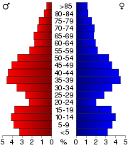
In the county, the population was spread out with 27.10% under the age of 18, 6.60% from 18 to 24, 30.40% from 25 to 44, 22.50% from 45 to 64, and 13.30% who were 65 years of age or older. The median age was 37 years. For every 100 females there were 99.30 males. For every 100 females age 18 and over, there were 97.70 males.
County (United States)
In the United States, a county is a geographic subdivision of a state , usually assigned some governmental authority. The term "county" is used in 48 of the 50 states; Louisiana is divided into parishes and Alaska into boroughs. Parishes and boroughs are called "county-equivalents" by the U.S...
located in the U.S. state
U.S. state
A U.S. state is any one of the 50 federated states of the United States of America that share sovereignty with the federal government. Because of this shared sovereignty, an American is a citizen both of the federal entity and of his or her state of domicile. Four states use the official title of...
of Wisconsin
Wisconsin
Wisconsin is a U.S. state located in the north-central United States and is part of the Midwest. It is bordered by Minnesota to the west, Iowa to the southwest, Illinois to the south, Lake Michigan to the east, Michigan to the northeast, and Lake Superior to the north. Wisconsin's capital is...
. As of 2000, the population was 22,780. Its county seat
County seat
A county seat is an administrative center, or seat of government, for a county or civil parish. The term is primarily used in the United States....
and largest city is Dodgeville
Dodgeville, Wisconsin
Dodgeville is the most populous city and county seat of Iowa County, Wisconsin, United States. The population was 4,698 at the 2010 census, making it the 9th largest city within the Madison metropolitan area. The Greater Dodgeville Area however had a population of 6,529...
.
Iowa County is part of the Madison
Madison, Wisconsin
Madison is the capital of the U.S. state of Wisconsin and the county seat of Dane County. It is also home to the University of Wisconsin–Madison....
Metropolitan Statistical Area
Madison metropolitan area
The Madison Metropolitan Statistical Area, as defined by the United States Census Bureau, is an area consisting of three counties in Wisconsin, anchored by the city of Madison. As of the 2010 census, the MSA had a population of 568,593.-Definitions:...
.
Geography
According to the U.S. Census BureauUnited States Census Bureau
The United States Census Bureau is the government agency that is responsible for the United States Census. It also gathers other national demographic and economic data...
, the county has a total area of 768 square miles (1,989.1 km²), of which 763 square miles (1,976.2 km²) is land and 5 square miles (12.9 km²) (0.70%) is water.
Major highways
 U.S. Highway 18
 U.S. Highway 151
 U.S. Highway 14


Adjacent counties
- Richland County - northwest
- Sauk CountySauk County, WisconsinSauk County is a county in the U.S. state of Wisconsin. As of 2000, the population was 55,225. Its county seat and largest city is Baraboo. Sauk County is included in the Baraboo Micropolitan Statistical Area and in the Madison Combined Statistical Area....
- northeast - Dane CountyDane County, WisconsinAs of the census of 2000, there were 426,526 people, 173,484 households, and 100,794 families residing in the county. The population density was 355 people per square mile . There were 180,398 housing units at an average density of 150 per square mile...
- east - Green CountyGreen County, WisconsinGreen County is a county located in the U.S. state of Wisconsin. As of 2000, the population was 33,647. Its county seat is Monroe.-Geography:According to the U.S...
- southeast - Lafayette CountyLafayette County, WisconsinLafayette County is a county located in the U.S. state of Wisconsin. As of 2000, the population was 16,137. Its county seat is Darlington.-Geography:According to the U.S...
- south - Grant CountyGrant County, WisconsinGrant County is a county located in the U.S. state of Wisconsin. As of 2000, the population was 49,597. Its county seat is Lancaster. Estimates for 2008 show a population of 49,238...
- west
Demographics
As of the census
Census
A census is the procedure of systematically acquiring and recording information about the members of a given population. It is a regularly occurring and official count of a particular population. The term is used mostly in connection with national population and housing censuses; other common...
of 2000, there were 22,780 people, 8,764 households, and 6,213 families residing in the county. The population density
Population density
Population density is a measurement of population per unit area or unit volume. It is frequently applied to living organisms, and particularly to humans...
was 30 people per square mile (12/km²). There were 9,579 housing units at an average density of 13 per square mile (5/km²). The racial makeup of the county was 98.70% White
Race (United States Census)
Race and ethnicity in the United States Census, as defined by the Federal Office of Management and Budget and the United States Census Bureau, are self-identification data items in which residents choose the race or races with which they most closely identify, and indicate whether or not they are...
, 0.17% Black
Race (United States Census)
Race and ethnicity in the United States Census, as defined by the Federal Office of Management and Budget and the United States Census Bureau, are self-identification data items in which residents choose the race or races with which they most closely identify, and indicate whether or not they are...
or African American
Race (United States Census)
Race and ethnicity in the United States Census, as defined by the Federal Office of Management and Budget and the United States Census Bureau, are self-identification data items in which residents choose the race or races with which they most closely identify, and indicate whether or not they are...
, 0.11% Native American
Race (United States Census)
Race and ethnicity in the United States Census, as defined by the Federal Office of Management and Budget and the United States Census Bureau, are self-identification data items in which residents choose the race or races with which they most closely identify, and indicate whether or not they are...
, 0.34% Asian
Race (United States Census)
Race and ethnicity in the United States Census, as defined by the Federal Office of Management and Budget and the United States Census Bureau, are self-identification data items in which residents choose the race or races with which they most closely identify, and indicate whether or not they are...
, 0.01% Pacific Islander
Race (United States Census)
Race and ethnicity in the United States Census, as defined by the Federal Office of Management and Budget and the United States Census Bureau, are self-identification data items in which residents choose the race or races with which they most closely identify, and indicate whether or not they are...
, 0.11% from other races
Race (United States Census)
Race and ethnicity in the United States Census, as defined by the Federal Office of Management and Budget and the United States Census Bureau, are self-identification data items in which residents choose the race or races with which they most closely identify, and indicate whether or not they are...
, and 0.55% from two or more races. 0.33% of the population were Hispanic
Race (United States Census)
Race and ethnicity in the United States Census, as defined by the Federal Office of Management and Budget and the United States Census Bureau, are self-identification data items in which residents choose the race or races with which they most closely identify, and indicate whether or not they are...
or Latino
Race (United States Census)
Race and ethnicity in the United States Census, as defined by the Federal Office of Management and Budget and the United States Census Bureau, are self-identification data items in which residents choose the race or races with which they most closely identify, and indicate whether or not they are...
of any race. 33.6% were of German, 17.2% Norwegian, 11.6% English
English people
The English are a nation and ethnic group native to England, who speak English. The English identity is of early mediaeval origin, when they were known in Old English as the Anglecynn. England is now a country of the United Kingdom, and the majority of English people in England are British Citizens...
, 11.3% Irish
Irish people
The Irish people are an ethnic group who originate in Ireland, an island in northwestern Europe. Ireland has been populated for around 9,000 years , with the Irish people's earliest ancestors recorded having legends of being descended from groups such as the Nemedians, Fomorians, Fir Bolg, Tuatha...
and 7.9% American
United States
The United States of America is a federal constitutional republic comprising fifty states and a federal district...
ancestry according to Census 2000.
There were 8,764 households out of which 34.60% had children under the age of 18 living with them, 59.50% were married couples
Marriage
Marriage is a social union or legal contract between people that creates kinship. It is an institution in which interpersonal relationships, usually intimate and sexual, are acknowledged in a variety of ways, depending on the culture or subculture in which it is found...
living together, 7.60% had a female householder with no husband present, and 29.10% were non-families. 24.30% of all households were made up of individuals and 10.10% had someone living alone who was 65 years of age or older. The average household size was 2.56 and the average family size was 3.06.
In the county, the population was spread out with 27.10% under the age of 18, 6.60% from 18 to 24, 30.40% from 25 to 44, 22.50% from 45 to 64, and 13.30% who were 65 years of age or older. The median age was 37 years. For every 100 females there were 99.30 males. For every 100 females age 18 and over, there were 97.70 males.
Cities, villages, and towns
Unincorporated communities
- Coon RockCoon Rock, WisconsinCoon Rock is an unincorporated community located in the town of Arena in Iowa County, Wisconsin, United States. Coon Rock is southeast of Spring Green....
- EdmundEdmund, WisconsinEdmund is an unincorporated census-designated place located in the town of Linden in Iowa County, Wisconsin, United States. Edmund is located on U.S. Route 18 west of Dodgeville. Edmund had a post office, which closed on November 2, 2002. As of the 2010 census, its population was 173....
- HelenaHelena, WisconsinHelena is an unincorporated community in the town of Arena in Iowa County, Wisconsin, United States.-Black Hawk War of 1832:In the 19th century Helena was a village that played an important role in the manufacture and shipping of lead shot...
- HydeHyde, WisconsinHyde is an unincorporated community located in the town of Ridgeway, Iowa County, Wisconsin, United States. Hyde is located on County Highway H north of the village of Ridgeway....
- JonesdaleJonesdale, WisconsinJonesdale is an unincorporated community located in the town of Waldwick, Iowa County, Wisconsin, United States. Jonesdale is located on County Highway W west-northwest of Hollandale....
- MifflinMifflin (community), WisconsinMifflin is an unincorporated community located in the town of Mifflin, Iowa County, Wisconsin, United States. Mifflin is located at the junction of County Highways E and G east-southeast of Livingston....
- MoscowMoscow (community), WisconsinMoscow is an unincorporated community in the town of Moscow, Iowa County, Wisconsin, United States....
- Pleasant RidgePleasant Ridge, WisconsinPleasant Ridge is an unincorporated community located in the town of Dodgeville, Iowa County, Wisconsin, United States. Pleasant Ridge is located at the intersection of County Highways Z and ZZ north-northeast of the city of Dodgeville....