
.gif)
Metrobus (Sydney)
Encyclopedia
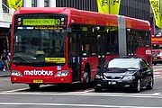
Metrobus is a high frequency, high capacity public transportation network in Sydney
that links key employment and growth centres. Metrobuses run every 10 minutes during peak periods, 15 minutes during off-peak weekday periods, and 20 minutes on weekends, with the intention of making timetables obsolete. All articulated high-capacity metrobuses can carry up to 115 passengers and are equipped with on-bus next stop displays and digital voice announcements, air conditioning and digital CCTV for enhanced security.
Services are largely integrated with the public transport network of Sydney
. Buses are painted in a distinctive red livery. All route numbers are prefixed with an "M", and follow the Sydney bus route numbering system, with the exception to the cross-CBD routes.
The first route, M10 began operation on a 12-month trial basis on October 12, 2008, during this period 9 regular buses and 6 new high-capacity metrobuses with different seating arrangements serviced the route.
In March 2009, the NSW government announced the expansion of the metrobus network with the addition of four further routes serving the inner suburbs (M20, M30, M40, M50).
On July 20, 2010, Transport Minister John Robertson
announced eight new Metrobus routes to be rolled out in 2011 to service suburbs in Sydney's west, north, north-west, south and south-west (M41, M52, M54, M60, M61, M90, M91, M92).
system. All STA metrobus services use the Automated Fare Collection System to validate tickets. Metrobus routes M10, M20, M30, M40 and M50 are full-time pre-pay only services and require commuters to purchase a ticket before boarding the bus.
M10 runs from Leichhardt
to Maroubra Junction
via Parramatta Road
, Town Hall Station and Anzac Parade
. The Route 10 metrobus service connects passengers to CityRail
stations at Central
, Town Hall and Museum stations and Metro Monorail stations at The Galeries Victoria
. It also allows passengers to transfer to regular buses to outer suburbs of Sydney at major transport interchanges such as Broadway, Railway Square, Sydney Town Hall, Museum, Cleveland Street, and Kingsford.
On 28 December 2008, Metrobus Route 10 services was modified to terminate and start from Norton Street, Leichhardt Town Hall instead. The Route 10 services no longer operate between Leichhardt Town Hall and MarketPlace, Leichhardt nor stop at bus stops at Cromwell Street and Elswick Street due to issues raised by Leichhardt Council
regarding bus parking in Lords Road at the MarketPlace terminus. On 14 November 2010, Metrobus Route 10 services were extended to the corner of Norton Street and William Street at Leichhardt Pioneer Park.
On 26 October 2009, Route 10 was extended from Kingsford
to Maroubra Junction
.
M20 runs from Gore Hill
to Botany
via Pacific Highway
, Town Hall Station and Botany Road. The service began on 26 October 2009. The M20 metrobus service connects passengers to CityRail
stations at Central
, Town Hall, Wynyard
, North Sydney and St Leonards stations. It also allows passengers to transfer to regular buses to outer suburbs of Sydney at major transport interchanges such as Railway Square, Sydney Town Hall, Wynyard, North Sydney and St Leonards.
On 27 February 2011, M20 was extended from Mascot to Botany shops
.
M30 runs from Mosman
to Sydenham
via Military Road, Town Hall Station and King Street, and began on 28 March 2010. The Route 30 metrobus service connects passengers to CityRail
stations at Wynyard
, Town Hall, Central
, Newtown
and Sydenham
stations. It also allows passengers to transfer to regular buses to outer suburbs of Sydney at major transport interchanges such as Railway Square, Sydney Town Hall, Wynyard, Neutral Bay Junction, and Spit Junction.
M40 runs from Chatswood
to Bondi Junction
via Willoughby Road, Wynyard Station
, Town Hall Station and Oxford Street
, and began on 18 July 2010. The Route 40 metrobus service connects passengers to CityRail
stations at Chatswood, Wynyard
, Town Hall, Museum and Bondi Junction stations. It also allows passengers to transfer to regular buses to outer suburbs of Sydney at major transport interchanges such as Chatswood, Sydney Town Hall, Wynyard, and Bondi Junction.
M41 runs from Hurstville
to Marsfield
via Bexley North, Clemton Park, Campsie, Burwood
and Top Ryde, and began on 19 December 2010. The Route 41 metrobus service connects passengers to CityRail
stations at Hurstville, Bexley North, Campsie, Burwood
, Rhodes, Macquarie Park and Macquarie University stations. It also allows passengers to transfer to regular buses to outer suburbs of Sydney at major transport interchanges such as Macquarie Centre, Top Ryde City and Hurstville.
M50 runs from Drummoyne
to Coogee
via Anzac Bridge, CBD and Fox Studios and Alison Road, and began on 31 October 2010. The Route 50 metrobus service connects passengers to CityRail
stations at Wynyard
, Town Hall, and Museum stations. It also allows passengers to transfer to regular buses to the Moore Park Area.
M52 runs from Parramatta
to Circular Quay via Victoria Road, Top Ryde
, Wynyard Station
, and Town Hall Station, and began on 8 August 2010. The Route 52 metrobus service connects passengers to CityRail
stations at Parramatta, West Ryde, Town Hall, Wynyard
and Circular Quay stations. It also allows passengers to transfer to regular buses to outer suburbs of Sydney at major transport interchanges such as Parramatta, Top Ryde, Sydney Town Hall, Wynyard, and Circular Quay. It has replaced the old L20 route and is supplemented by the current 520 route outside of the Metrobus operating hours.
M54 runs from Parramatta
to Macquarie Park via Carlingford and Epping, and began on 10 October 2010. The Route 54 metrobus service connects passengers to CityRail
stations at Parramatta, Carlingford, Epping
, Macquarie University, and Macquarie Park stations. It also allows passengers to transfer to regular buses to outer suburbs of Sydney at major transport interchanges such as Parramatta, Epping, and Macquarie Centre. It replaced the old 548 route.
M60 runs from Parramatta
to Hornsby
via Baulkham Hills
, Castle Hill
, Cherrybrook
, Pennant Hills
, Thornleigh
and Normanhurst
, and began on 7 March 2011. It connects with Parramatta, Pennant Hills and Hornsby CityRail
stations and other bus services at major interchanges Parramatta, Castle Hill and Hornsby. It replaced the 600 service between Parramatta and Castle Hill, and complements the 632 service between Pennant Hills and Hornsby.
M61 runs from Castle Hill
to Railway Square via Baulkham Hills and the M2 Busway and complements the existing 610X service. It began on 20 December 2010. The service allows passengers to connect with services to Kellyville
, Glenwood
, Kellyville Ridge, Bella Vista
and Stanhope Gardens at bus stops along the M2 Motorway, as well as the Castle Hill Interchange.
M90 runs from Burwood
to Liverpool
via Strathfield, Chullora, Greenacre, Bankstown, Milperra and Moorebank, and began on 6 December 2010. The M90 service replaced the 900 service and connects passengers to CityRail
stations at Strathfield, Burwood
, Bankstown, and Liverpool stations. It also allows passengers to transfer to other buses in Burwood, Strathfield, Bankstown and Liverpool. M90 also connects to the M91 and M92 services at Bankstown and with the Liverpool-Parramatta T-way
.
M91 runs from Parramatta
to Hurstville
via Granville, South Granville, Chester Hill, Yagoona, Bankstown, Padstow, Peakhurst and Penshurst, and began on 7 February 2011. The M91 service replaces the 910 and 948 services and connects passengers to CityRail
stations at Parramatta, Granville, Chester Hill, Yagoona, Bankstown, Padstow
, and Hurstville stations. M91 connects with the M52, M54, M60 and M92 services at Parramatta, the M90 and M92 services at Bankstown and the M41 service at Hurstville as well as connecting with local bus services.
M92 runs from Parramatta
to Sutherland
via Lidcombe, Bankstown, Padstow and Menai, and began 14 March 2011, it marked the last Metrobus route launched to date.
, Leichhardt
, Tempe
, Ryde
or Port Botany depots. The fleet consists of:
High capacity buses
Standard buses
Sydney
Sydney is the most populous city in Australia and the state capital of New South Wales. Sydney is located on Australia's south-east coast of the Tasman Sea. As of June 2010, the greater metropolitan area had an approximate population of 4.6 million people...
that links key employment and growth centres. Metrobuses run every 10 minutes during peak periods, 15 minutes during off-peak weekday periods, and 20 minutes on weekends, with the intention of making timetables obsolete. All articulated high-capacity metrobuses can carry up to 115 passengers and are equipped with on-bus next stop displays and digital voice announcements, air conditioning and digital CCTV for enhanced security.
Services are largely integrated with the public transport network of Sydney
Sydney
Sydney is the most populous city in Australia and the state capital of New South Wales. Sydney is located on Australia's south-east coast of the Tasman Sea. As of June 2010, the greater metropolitan area had an approximate population of 4.6 million people...
. Buses are painted in a distinctive red livery. All route numbers are prefixed with an "M", and follow the Sydney bus route numbering system, with the exception to the cross-CBD routes.
History
The network originally operated along bus trunk routes through the inner suburbs, but passed through the CBD rather than terminating there. This reduced overcrowding on the trunk routes without needing to layover extra buses in the CBD. This concept was later diluted with the network's expansion to include long distance routes servicing major activity centres in the greater western suburbs.The first route, M10 began operation on a 12-month trial basis on October 12, 2008, during this period 9 regular buses and 6 new high-capacity metrobuses with different seating arrangements serviced the route.
In March 2009, the NSW government announced the expansion of the metrobus network with the addition of four further routes serving the inner suburbs (M20, M30, M40, M50).
On July 20, 2010, Transport Minister John Robertson
John Robertson (New South Wales politician)
John Cameron Robertson MP , an Australian politician, is the Leader of the Australian Labor Party in New South Wales and the Leader of the Opposition. Robertson is a member of the New South Wales Legislative Assembly representing Blacktown for Labor since 2011...
announced eight new Metrobus routes to be rolled out in 2011 to service suburbs in Sydney's west, north, north-west, south and south-west (M41, M52, M54, M60, M61, M90, M91, M92).
Tickets and fares
Metrobus services are integrated with the MyZoneMyZone
MyZone is a public transport fare structure in the Greater Sydney area of New South Wales, Australia. It covers transport on CityRail trains, the publicly-owned Sydney Buses network, private buses, and the publicly-owned Sydney Ferries network throughout the Sydney metropolitan area, as well as in...
system. All STA metrobus services use the Automated Fare Collection System to validate tickets. Metrobus routes M10, M20, M30, M40 and M50 are full-time pre-pay only services and require commuters to purchase a ticket before boarding the bus.
M10: Leichhardt to Maroubra Junction
Operated by State Transit AuthorityM10 runs from Leichhardt
Leichhardt, New South Wales
Leichhardt is a suburb in the inner-west of Sydney in New South Wales, Australia. Leichhardt is located 5 kilometres west of the Sydney central business district and is the administrative centre for the local government area of the Municipality of Leichhardt...
to Maroubra Junction
Maroubra Junction, New South Wales
Maroubra Junction is a locality of the suburb of Maroubra in Sydney, in the state of New South Wales, Australia. It is situated around the junction of Anzac Parade and Maroubra Road...
via Parramatta Road
Parramatta Road
.Parramatta Road is the major historical east-west artery of metropolitan Sydney, Australia, connecting the Sydney with Parramatta. It is the eastern-most part of the Great Western Highway. Much of its traffic has been diverted to modern expressways such as the M4 and the City West Link...
, Town Hall Station and Anzac Parade
Anzac Parade, Sydney
Anzac Parade is a major road in the south-eastern suburbs of Sydney, New South Wales, Australia. It included part of the marathon during the 2000 Summer Olympics, and the blue line denoting the marathon's path still exists today.-Description:...
. The Route 10 metrobus service connects passengers to CityRail
CityRail
CityRail is an operating brand of RailCorp, a corporation owned by the state government of New South Wales, Australia. It is responsible for providing commuter rail services, and some coach services, in and around Sydney, Newcastle and Wollongong, the three largest cities of New South Wales. It is...
stations at Central
Central railway station, Sydney
Central Railway Station, the largest railway station in Australia, is at the southern end of the Sydney CBD. It services almost all the lines on the CityRail network, and is the major terminus for interurban and interstate rail services...
, Town Hall and Museum stations and Metro Monorail stations at The Galeries Victoria
The Galeries Victoria
The Galeries Victoria is a shopping centre in Sydney, New South Wales, Australia. It is located in the heart of the Sydney central business district, bounded by George, Pitt and Park Streets...
. It also allows passengers to transfer to regular buses to outer suburbs of Sydney at major transport interchanges such as Broadway, Railway Square, Sydney Town Hall, Museum, Cleveland Street, and Kingsford.
On 28 December 2008, Metrobus Route 10 services was modified to terminate and start from Norton Street, Leichhardt Town Hall instead. The Route 10 services no longer operate between Leichhardt Town Hall and MarketPlace, Leichhardt nor stop at bus stops at Cromwell Street and Elswick Street due to issues raised by Leichhardt Council
Municipality of Leichhardt
The Municipality of Leichhardt is a Local Government Area in the inner-west of Sydney, in state of New South Wales, Australia.-History:The Municipality of Leichhardt stands on land that traditionally belonged to the Gadigal and Wangal people, of the Eora nation...
regarding bus parking in Lords Road at the MarketPlace terminus. On 14 November 2010, Metrobus Route 10 services were extended to the corner of Norton Street and William Street at Leichhardt Pioneer Park.
On 26 October 2009, Route 10 was extended from Kingsford
Kingsford, New South Wales
Kingsford is a suburb in south-eastern Sydney, in the state of New South Wales, Australia. Kingsford is located 7 kilometres south-east of the Sydney central business district, in the local government area of the City of Randwick...
to Maroubra Junction
Maroubra Junction, New South Wales
Maroubra Junction is a locality of the suburb of Maroubra in Sydney, in the state of New South Wales, Australia. It is situated around the junction of Anzac Parade and Maroubra Road...
.
| Route Diagram | ||||||||||||||||||||||||||||||||||||||||||||||||||||||||||||||||||||||||||||||||||||||||||||||||||||||||||||||||||||||||||||||||||||||||||||||||||||||||||||||||||||||||||||||||||||||||||||||||||||||||||||||||||||||||||||||||
|---|---|---|---|---|---|---|---|---|---|---|---|---|---|---|---|---|---|---|---|---|---|---|---|---|---|---|---|---|---|---|---|---|---|---|---|---|---|---|---|---|---|---|---|---|---|---|---|---|---|---|---|---|---|---|---|---|---|---|---|---|---|---|---|---|---|---|---|---|---|---|---|---|---|---|---|---|---|---|---|---|---|---|---|---|---|---|---|---|---|---|---|---|---|---|---|---|---|---|---|---|---|---|---|---|---|---|---|---|---|---|---|---|---|---|---|---|---|---|---|---|---|---|---|---|---|---|---|---|---|---|---|---|---|---|---|---|---|---|---|---|---|---|---|---|---|---|---|---|---|---|---|---|---|---|---|---|---|---|---|---|---|---|---|---|---|---|---|---|---|---|---|---|---|---|---|---|---|---|---|---|---|---|---|---|---|---|---|---|---|---|---|---|---|---|---|---|---|---|---|---|---|---|---|---|---|---|---|---|---|---|---|---|---|---|---|---|---|---|---|---|---|---|---|---|
EWLINE
|
||||||||||||||||||||||||||||||||||||||||||||||||||||||||||||||||||||||||||||||||||||||||||||||||||||||||||||||||||||||||||||||||||||||||||||||||||||||||||||||||||||||||||||||||||||||||||||||||||||||||||||||||||||||||||||||||
M20: Gore Hill to Botany
Operated by State Transit AuthorityM20 runs from Gore Hill
Gore Hill, New South Wales
Gore Hill is an urban locality on the North Shore of Sydney, in the state of New South Wales, Australia. Gore Hill is located in the western part of the suburb of St Leonards....
to Botany
Botany, New South Wales
Botany is a suburb in south-eastern Sydney, in the state of New South Wales, Australia. Botany is located 10 kilometres south of the Sydney central business district and is part of the City of Botany Bay....
via Pacific Highway
Pacific Highway (Australia)
The Pacific Highway is a major transport route along part of the east coast of Australia and is part of Australia's national route 1.It is 960 km long and links Sydney, the capital of New South Wales, to Brisbane, the capital of Queensland, along the coast, via Gosford, Newcastle, Taree, Port...
, Town Hall Station and Botany Road. The service began on 26 October 2009. The M20 metrobus service connects passengers to CityRail
CityRail
CityRail is an operating brand of RailCorp, a corporation owned by the state government of New South Wales, Australia. It is responsible for providing commuter rail services, and some coach services, in and around Sydney, Newcastle and Wollongong, the three largest cities of New South Wales. It is...
stations at Central
Central railway station, Sydney
Central Railway Station, the largest railway station in Australia, is at the southern end of the Sydney CBD. It services almost all the lines on the CityRail network, and is the major terminus for interurban and interstate rail services...
, Town Hall, Wynyard
Wynyard railway station, Sydney
Wynyard is a major underground CityRail station in the central business district of Sydney, Australia, 2.05 km from Central. Wynyard averages 108000 passenger movements per day Monday to Friday.-History:The station opened on 28 February 1932...
, North Sydney and St Leonards stations. It also allows passengers to transfer to regular buses to outer suburbs of Sydney at major transport interchanges such as Railway Square, Sydney Town Hall, Wynyard, North Sydney and St Leonards.
On 27 February 2011, M20 was extended from Mascot to Botany shops
Botany, New South Wales
Botany is a suburb in south-eastern Sydney, in the state of New South Wales, Australia. Botany is located 10 kilometres south of the Sydney central business district and is part of the City of Botany Bay....
.
| Route Diagram | ||||||||||||||||||||||||||||||||||||||||||||||||||||||||||||||||||||||||||||||||||||||||||||||||||||||||||||||||||||||||||||||||||||||||||||||||||||||||||||||||||||||||||||||||||||||||||||||||||||||||||||||||||||||||||||
|---|---|---|---|---|---|---|---|---|---|---|---|---|---|---|---|---|---|---|---|---|---|---|---|---|---|---|---|---|---|---|---|---|---|---|---|---|---|---|---|---|---|---|---|---|---|---|---|---|---|---|---|---|---|---|---|---|---|---|---|---|---|---|---|---|---|---|---|---|---|---|---|---|---|---|---|---|---|---|---|---|---|---|---|---|---|---|---|---|---|---|---|---|---|---|---|---|---|---|---|---|---|---|---|---|---|---|---|---|---|---|---|---|---|---|---|---|---|---|---|---|---|---|---|---|---|---|---|---|---|---|---|---|---|---|---|---|---|---|---|---|---|---|---|---|---|---|---|---|---|---|---|---|---|---|---|---|---|---|---|---|---|---|---|---|---|---|---|---|---|---|---|---|---|---|---|---|---|---|---|---|---|---|---|---|---|---|---|---|---|---|---|---|---|---|---|---|---|---|---|---|---|---|---|---|---|---|---|---|---|---|---|---|---|---|---|---|---|---|---|---|
EWLINE
|
||||||||||||||||||||||||||||||||||||||||||||||||||||||||||||||||||||||||||||||||||||||||||||||||||||||||||||||||||||||||||||||||||||||||||||||||||||||||||||||||||||||||||||||||||||||||||||||||||||||||||||||||||||||||||||
M30: Mosman to Sydenham
Operated by State Transit AuthorityM30 runs from Mosman
Mosman, New South Wales
Mosman is a suburb on the Lower North Shore of Sydney, in the state of New South Wales, Australia. Mosman is located 8 kilometres north-east of the Sydney central business district and is the administrative centre for the local government area of the Municipality of Mosman.-Localities:In February...
to Sydenham
Sydenham, New South Wales
For other places called Sydenham, see Sydenham .Sydenham is a small suburb in the inner-west of Sydney, in the state of New South Wales, Australia. Sydenham is located 8 kilometres south of Sydney central business district and is part of the local government area of Marrickville Council...
via Military Road, Town Hall Station and King Street, and began on 28 March 2010. The Route 30 metrobus service connects passengers to CityRail
CityRail
CityRail is an operating brand of RailCorp, a corporation owned by the state government of New South Wales, Australia. It is responsible for providing commuter rail services, and some coach services, in and around Sydney, Newcastle and Wollongong, the three largest cities of New South Wales. It is...
stations at Wynyard
Wynyard railway station, Sydney
Wynyard is a major underground CityRail station in the central business district of Sydney, Australia, 2.05 km from Central. Wynyard averages 108000 passenger movements per day Monday to Friday.-History:The station opened on 28 February 1932...
, Town Hall, Central
Central railway station, Sydney
Central Railway Station, the largest railway station in Australia, is at the southern end of the Sydney CBD. It services almost all the lines on the CityRail network, and is the major terminus for interurban and interstate rail services...
, Newtown
Newtown railway station, Sydney
-Transport links:Sydney Buses runs nine routes via Newtown station:*Route 352 - weekdays daytime services - between Bondi Junction Interchange and Marrickville Metro Shopping Centre...
and Sydenham
Sydenham railway station, Sydney
Sydenham railway station is a major interchange station located in the small Sydney suburb of Sydenham, serving the East Hills, Illawarra and Bankstown lines on the CityRail system. The Illawarra line platforms are also used by a very small number of South Coast line services. The station is...
stations. It also allows passengers to transfer to regular buses to outer suburbs of Sydney at major transport interchanges such as Railway Square, Sydney Town Hall, Wynyard, Neutral Bay Junction, and Spit Junction.
| Route Diagram | ||||||||||||||||||||||||||||||||||||||||||||||||||||||||||||||||||||||||||||||||||||||||||||||||||||||||||||||||||||||||||||||||||||||||||||||||||||||||||||||||||||
|---|---|---|---|---|---|---|---|---|---|---|---|---|---|---|---|---|---|---|---|---|---|---|---|---|---|---|---|---|---|---|---|---|---|---|---|---|---|---|---|---|---|---|---|---|---|---|---|---|---|---|---|---|---|---|---|---|---|---|---|---|---|---|---|---|---|---|---|---|---|---|---|---|---|---|---|---|---|---|---|---|---|---|---|---|---|---|---|---|---|---|---|---|---|---|---|---|---|---|---|---|---|---|---|---|---|---|---|---|---|---|---|---|---|---|---|---|---|---|---|---|---|---|---|---|---|---|---|---|---|---|---|---|---|---|---|---|---|---|---|---|---|---|---|---|---|---|---|---|---|---|---|---|---|---|---|---|---|---|---|---|---|---|---|---|
EWLINE
|
||||||||||||||||||||||||||||||||||||||||||||||||||||||||||||||||||||||||||||||||||||||||||||||||||||||||||||||||||||||||||||||||||||||||||||||||||||||||||||||||||||
M40: Chatswood to Bondi Junction
Operated by State Transit AuthorityM40 runs from Chatswood
Chatswood, New South Wales
Chatswood is a suburb on the North Shore of Sydney, in the state of New South Wales, Australia. Chatswood is located 10 kilometres north of the Sydney central business district and is the administrative centre of the local government area of the City of Willoughby. Chatswood West is a separate suburb...
to Bondi Junction
Bondi Junction, New South Wales
Bondi Junction is an eastern suburb of Sydney, in the state of New South Wales, Australia. Bondi Junction is located 6 kilometres east of the Sydney central business district and is part of the local government area of the Waverley....
via Willoughby Road, Wynyard Station
Wynyard railway station, Sydney
Wynyard is a major underground CityRail station in the central business district of Sydney, Australia, 2.05 km from Central. Wynyard averages 108000 passenger movements per day Monday to Friday.-History:The station opened on 28 February 1932...
, Town Hall Station and Oxford Street
Oxford Street, Sydney
Oxford Street is a major thoroughfare in Sydney, Australia running from Whitlam Square on the south-east corner of Hyde Park in the central business district of Sydney to Bondi Junction in the Eastern Suburbs. Close to the CBD in particular, the street is lined with numerous shops, bars and...
, and began on 18 July 2010. The Route 40 metrobus service connects passengers to CityRail
CityRail
CityRail is an operating brand of RailCorp, a corporation owned by the state government of New South Wales, Australia. It is responsible for providing commuter rail services, and some coach services, in and around Sydney, Newcastle and Wollongong, the three largest cities of New South Wales. It is...
stations at Chatswood, Wynyard
Wynyard railway station, Sydney
Wynyard is a major underground CityRail station in the central business district of Sydney, Australia, 2.05 km from Central. Wynyard averages 108000 passenger movements per day Monday to Friday.-History:The station opened on 28 February 1932...
, Town Hall, Museum and Bondi Junction stations. It also allows passengers to transfer to regular buses to outer suburbs of Sydney at major transport interchanges such as Chatswood, Sydney Town Hall, Wynyard, and Bondi Junction.
| Route Diagram | ||||||||||||||||||||||||||||||||||||||||||||||||||||||||||||||||||||||||||||||||||||||||||||||||||||||||||||||||||||||||||||||||||||||||||||||||||||||||||||||||||||||||
|---|---|---|---|---|---|---|---|---|---|---|---|---|---|---|---|---|---|---|---|---|---|---|---|---|---|---|---|---|---|---|---|---|---|---|---|---|---|---|---|---|---|---|---|---|---|---|---|---|---|---|---|---|---|---|---|---|---|---|---|---|---|---|---|---|---|---|---|---|---|---|---|---|---|---|---|---|---|---|---|---|---|---|---|---|---|---|---|---|---|---|---|---|---|---|---|---|---|---|---|---|---|---|---|---|---|---|---|---|---|---|---|---|---|---|---|---|---|---|---|---|---|---|---|---|---|---|---|---|---|---|---|---|---|---|---|---|---|---|---|---|---|---|---|---|---|---|---|---|---|---|---|---|---|---|---|---|---|---|---|---|---|---|---|---|---|---|---|---|
EWLINE
|
||||||||||||||||||||||||||||||||||||||||||||||||||||||||||||||||||||||||||||||||||||||||||||||||||||||||||||||||||||||||||||||||||||||||||||||||||||||||||||||||||||||||
M41: Hurstville to Macquarie Park Station
Operated by State Transit AuthorityM41 runs from Hurstville
Hurstville, New South Wales
Hurstville is a suburb in southern Sydney, in the state of New South Wales, Australia. Hurstville is located 16 kilometres south of the Sydney central business district and is part of the St George area. Hurstville is the administrative centre of the local government area of the City of...
to Marsfield
Marsfield, New South Wales
Marsfield is a suburb on the Northern Suburbs of Sydney, in the state of New South Wales, Australia. Marsfield is located 16 kilometres north-west of the Sydney central business district in the local government area of the City of Ryde.-History:...
via Bexley North, Clemton Park, Campsie, Burwood
Burwood, New South Wales
Burwood is a suburb in the inner-west of Sydney, in the state of New South Wales, Australia. Burwood is located 12 kilometres west of the Sydney central business district and is the administrative centre for the local government area of Burwood Council....
and Top Ryde, and began on 19 December 2010. The Route 41 metrobus service connects passengers to CityRail
CityRail
CityRail is an operating brand of RailCorp, a corporation owned by the state government of New South Wales, Australia. It is responsible for providing commuter rail services, and some coach services, in and around Sydney, Newcastle and Wollongong, the three largest cities of New South Wales. It is...
stations at Hurstville, Bexley North, Campsie, Burwood
Burwood railway station, Sydney
Burwood is a major station on the main suburban line in the suburb of Burwood in Sydney. The station is located on Burwood Road, close to major shops and schools, and consists of platforms on all six of the tracks through the station. The concourse is situated below the platforms with access to...
, Rhodes, Macquarie Park and Macquarie University stations. It also allows passengers to transfer to regular buses to outer suburbs of Sydney at major transport interchanges such as Macquarie Centre, Top Ryde City and Hurstville.
M50: Drummoyne to Coogee
Operated by State Transit AuthorityM50 runs from Drummoyne
Drummoyne, New South Wales
Drummoyne is a suburb in the inner west of Sydney, in the state of New South Wales, Australia. It is located 6 kilometres west of the Sydney central business district and is the administrative centre for the local government area of the City of Canada Bay....
to Coogee
Coogee, New South Wales
Coogee is a beachside suburb of local government area City of Randwick. It is located 8 kilometres south-east of the Sydney central business district, in the state of New South Wales, Australia. It is also a part of the Eastern Suburbs of Sydney....
via Anzac Bridge, CBD and Fox Studios and Alison Road, and began on 31 October 2010. The Route 50 metrobus service connects passengers to CityRail
CityRail
CityRail is an operating brand of RailCorp, a corporation owned by the state government of New South Wales, Australia. It is responsible for providing commuter rail services, and some coach services, in and around Sydney, Newcastle and Wollongong, the three largest cities of New South Wales. It is...
stations at Wynyard
Wynyard railway station, Sydney
Wynyard is a major underground CityRail station in the central business district of Sydney, Australia, 2.05 km from Central. Wynyard averages 108000 passenger movements per day Monday to Friday.-History:The station opened on 28 February 1932...
, Town Hall, and Museum stations. It also allows passengers to transfer to regular buses to the Moore Park Area.
M52: Parramatta to Circular Quay
Operated by State Transit AuthorityM52 runs from Parramatta
Parramatta, New South Wales
Parramatta is a suburb of Sydney, in the state of New South Wales, Australia. It is located in Greater Western Sydney west of the Sydney central business district on the banks of the Parramatta River. Parramatta is the administrative seat of the Local Government Area of the City of Parramatta...
to Circular Quay via Victoria Road, Top Ryde
Top Ryde City
Top Ryde City is a shopping centre in Ryde, New South Wales. The centre occupies a 3.5 hectare block bounded by Blaxland Road, Devlin Street, Pope Street and Tucker Street. The centre has retail space of 78,125 square metres across 6 floors of commercial space.-Pre-2007 History:The original Top...
, Wynyard Station
Wynyard railway station, Sydney
Wynyard is a major underground CityRail station in the central business district of Sydney, Australia, 2.05 km from Central. Wynyard averages 108000 passenger movements per day Monday to Friday.-History:The station opened on 28 February 1932...
, and Town Hall Station, and began on 8 August 2010. The Route 52 metrobus service connects passengers to CityRail
CityRail
CityRail is an operating brand of RailCorp, a corporation owned by the state government of New South Wales, Australia. It is responsible for providing commuter rail services, and some coach services, in and around Sydney, Newcastle and Wollongong, the three largest cities of New South Wales. It is...
stations at Parramatta, West Ryde, Town Hall, Wynyard
Wynyard railway station, Sydney
Wynyard is a major underground CityRail station in the central business district of Sydney, Australia, 2.05 km from Central. Wynyard averages 108000 passenger movements per day Monday to Friday.-History:The station opened on 28 February 1932...
and Circular Quay stations. It also allows passengers to transfer to regular buses to outer suburbs of Sydney at major transport interchanges such as Parramatta, Top Ryde, Sydney Town Hall, Wynyard, and Circular Quay. It has replaced the old L20 route and is supplemented by the current 520 route outside of the Metrobus operating hours.
| Route Diagram | ||||||||||||||||||||||||||||||||||||||||||||||||||||||||||||||||||||||||||||||||||||||||||||||||||||||||||||||||||||||||||||||||||||||||||||||||||||||||||||||||||||||||||||||||||||||||||||||||||||||||||||||||||||||||||||||||||||||||||||
|---|---|---|---|---|---|---|---|---|---|---|---|---|---|---|---|---|---|---|---|---|---|---|---|---|---|---|---|---|---|---|---|---|---|---|---|---|---|---|---|---|---|---|---|---|---|---|---|---|---|---|---|---|---|---|---|---|---|---|---|---|---|---|---|---|---|---|---|---|---|---|---|---|---|---|---|---|---|---|---|---|---|---|---|---|---|---|---|---|---|---|---|---|---|---|---|---|---|---|---|---|---|---|---|---|---|---|---|---|---|---|---|---|---|---|---|---|---|---|---|---|---|---|---|---|---|---|---|---|---|---|---|---|---|---|---|---|---|---|---|---|---|---|---|---|---|---|---|---|---|---|---|---|---|---|---|---|---|---|---|---|---|---|---|---|---|---|---|---|---|---|---|---|---|---|---|---|---|---|---|---|---|---|---|---|---|---|---|---|---|---|---|---|---|---|---|---|---|---|---|---|---|---|---|---|---|---|---|---|---|---|---|---|---|---|---|---|---|---|---|---|---|---|---|---|---|---|---|---|---|---|---|---|---|---|---|---|
EWLINE
|
||||||||||||||||||||||||||||||||||||||||||||||||||||||||||||||||||||||||||||||||||||||||||||||||||||||||||||||||||||||||||||||||||||||||||||||||||||||||||||||||||||||||||||||||||||||||||||||||||||||||||||||||||||||||||||||||||||||||||||
M54: Parramatta to Macquarie Park
Operated by State Transit AuthorityM54 runs from Parramatta
Parramatta, New South Wales
Parramatta is a suburb of Sydney, in the state of New South Wales, Australia. It is located in Greater Western Sydney west of the Sydney central business district on the banks of the Parramatta River. Parramatta is the administrative seat of the Local Government Area of the City of Parramatta...
to Macquarie Park via Carlingford and Epping, and began on 10 October 2010. The Route 54 metrobus service connects passengers to CityRail
CityRail
CityRail is an operating brand of RailCorp, a corporation owned by the state government of New South Wales, Australia. It is responsible for providing commuter rail services, and some coach services, in and around Sydney, Newcastle and Wollongong, the three largest cities of New South Wales. It is...
stations at Parramatta, Carlingford, Epping
Epping railway station, Sydney
Epping railway station is on the Northern Line of the CityRail network in Sydney, Australia. It serves the suburb of Epping, a significant commercial and residential area. Epping is a significant interchange station and is the western terminus of the Epping to Chatswood Line...
, Macquarie University, and Macquarie Park stations. It also allows passengers to transfer to regular buses to outer suburbs of Sydney at major transport interchanges such as Parramatta, Epping, and Macquarie Centre. It replaced the old 548 route.
| Route Diagram | ||||||||||||||||||||||||||||||||||||||||||||||||||||||||||||||||||||||||||||||||||||||||||||||||||||||||||||||||||||||||||||||||||||||||||||||||||||||||||||||||||||||||||||||||||||||||||||||||||||||||||||||||||||||||||||||||
|---|---|---|---|---|---|---|---|---|---|---|---|---|---|---|---|---|---|---|---|---|---|---|---|---|---|---|---|---|---|---|---|---|---|---|---|---|---|---|---|---|---|---|---|---|---|---|---|---|---|---|---|---|---|---|---|---|---|---|---|---|---|---|---|---|---|---|---|---|---|---|---|---|---|---|---|---|---|---|---|---|---|---|---|---|---|---|---|---|---|---|---|---|---|---|---|---|---|---|---|---|---|---|---|---|---|---|---|---|---|---|---|---|---|---|---|---|---|---|---|---|---|---|---|---|---|---|---|---|---|---|---|---|---|---|---|---|---|---|---|---|---|---|---|---|---|---|---|---|---|---|---|---|---|---|---|---|---|---|---|---|---|---|---|---|---|---|---|---|---|---|---|---|---|---|---|---|---|---|---|---|---|---|---|---|---|---|---|---|---|---|---|---|---|---|---|---|---|---|---|---|---|---|---|---|---|---|---|---|---|---|---|---|---|---|---|---|---|---|---|---|---|---|---|---|
EWLINE
|
||||||||||||||||||||||||||||||||||||||||||||||||||||||||||||||||||||||||||||||||||||||||||||||||||||||||||||||||||||||||||||||||||||||||||||||||||||||||||||||||||||||||||||||||||||||||||||||||||||||||||||||||||||||||||||||||
M60: Parramatta to Hornsby
Operated by HillsbusM60 runs from Parramatta
Parramatta, New South Wales
Parramatta is a suburb of Sydney, in the state of New South Wales, Australia. It is located in Greater Western Sydney west of the Sydney central business district on the banks of the Parramatta River. Parramatta is the administrative seat of the Local Government Area of the City of Parramatta...
to Hornsby
Hornsby, New South Wales
* Highest Maximum Temperature: 42 °C* Lowest Maximum Temperature: 4.9 °C* Warmest Month: January* Coolest Month: July* Highest Precipitation: February* Lowest Precipitation: July-Notable residents:...
via Baulkham Hills
Baulkham Hills, New South Wales
Baulkham Hills is a suburb in the north-west of Sydney, in the state of New South Wales, Australia. Baulkham Hills is located 31 kilometres north-west of the Sydney central business district in the local government area of The Hills Shire...
, Castle Hill
Castle Hill, New South Wales
Castle Hill is a suburb in the north-west of Sydney, in the state of New South Wales, Australia. Castle Hill is located 31 kilometres north-west of the Sydney central business district, in the Hills District of the Greater Western Sydney region...
, Cherrybrook
Cherrybrook, New South Wales
Cherrybrook is a suburb of Sydney, in the state of New South Wales, Australia. Cherrybrook is located 27 kilometres north-west of the Sydney central business district in the local government area of Hornsby Shire...
, Pennant Hills
Pennant Hills, New South Wales
Pennant Hills is a suburb of Sydney, New South Wales, Australia. Pennant Hills is located 25 kilometres north-west of the Sydney central business district in the local government area of Hornsby Shire...
, Thornleigh
Thornleigh, New South Wales
Thornleigh is a suburb of Sydney, in the state of New South Wales, Australia. Thornleigh is located north-west of the Sydney central business district in the local government area of Hornsby Shire...
and Normanhurst
Normanhurst, New South Wales
Normanhurst is a suburb of Sydney, in the state of New South Wales, Australia. Normanhurst is located 23 kilometres north-west of the Sydney central business district in the local government area of Hornsby Shire.-History:...
, and began on 7 March 2011. It connects with Parramatta, Pennant Hills and Hornsby CityRail
CityRail
CityRail is an operating brand of RailCorp, a corporation owned by the state government of New South Wales, Australia. It is responsible for providing commuter rail services, and some coach services, in and around Sydney, Newcastle and Wollongong, the three largest cities of New South Wales. It is...
stations and other bus services at major interchanges Parramatta, Castle Hill and Hornsby. It replaced the 600 service between Parramatta and Castle Hill, and complements the 632 service between Pennant Hills and Hornsby.
M61: Castle Hill to Railway Square
Operated by HillsbusM61 runs from Castle Hill
Castle Hill, New South Wales
Castle Hill is a suburb in the north-west of Sydney, in the state of New South Wales, Australia. Castle Hill is located 31 kilometres north-west of the Sydney central business district, in the Hills District of the Greater Western Sydney region...
to Railway Square via Baulkham Hills and the M2 Busway and complements the existing 610X service. It began on 20 December 2010. The service allows passengers to connect with services to Kellyville
Kellyville, New South Wales
Kellyville is a suburb of Sydney, in the state of New South Wales, Australia. Kellyville is located 36 kilometres north-west of the Sydney central business district in the local government area of The Hills Shire, part of the Hills District region.-History:...
, Glenwood
Glenwood, New South Wales
Glenwood is a suburb of Sydney, in the state of New South Wales, Australia. Glenwood is located 40 kilometres west of the Sydney central business district in the local government area of the City of Blacktown...
, Kellyville Ridge, Bella Vista
Bella Vista, New South Wales
Bella Vista is a suburb of north-western Sydney, in the state of New South Wales, Australia. Bella Vista is located 33 kilometres west of the Sydney central business district, in the local government area of the The Hills Shire. Bella Vista is part of the Greater Western Sydney region and the Hills...
and Stanhope Gardens at bus stops along the M2 Motorway, as well as the Castle Hill Interchange.
| Route Diagram | |||||||||||||||||||||||||||||||||||||||||||||||||||||||||||||||||||||||||||||||||||||||||||||||||||||||||||||||
|---|---|---|---|---|---|---|---|---|---|---|---|---|---|---|---|---|---|---|---|---|---|---|---|---|---|---|---|---|---|---|---|---|---|---|---|---|---|---|---|---|---|---|---|---|---|---|---|---|---|---|---|---|---|---|---|---|---|---|---|---|---|---|---|---|---|---|---|---|---|---|---|---|---|---|---|---|---|---|---|---|---|---|---|---|---|---|---|---|---|---|---|---|---|---|---|---|---|---|---|---|---|---|---|---|---|---|---|---|---|---|---|
EWLINE
|
|||||||||||||||||||||||||||||||||||||||||||||||||||||||||||||||||||||||||||||||||||||||||||||||||||||||||||||||
M90: Burwood to Liverpool
Operated by Veolia Transport NSWM90 runs from Burwood
Burwood, New South Wales
Burwood is a suburb in the inner-west of Sydney, in the state of New South Wales, Australia. Burwood is located 12 kilometres west of the Sydney central business district and is the administrative centre for the local government area of Burwood Council....
to Liverpool
Liverpool, New South Wales
Liverpool is a suburb in south-western Sydney, in the state of New South Wales, Australia. Liverpool is located 32 km south-west of the Sydney central business district, and is the administrative centre of the local government area of the City of Liverpool...
via Strathfield, Chullora, Greenacre, Bankstown, Milperra and Moorebank, and began on 6 December 2010. The M90 service replaced the 900 service and connects passengers to CityRail
CityRail
CityRail is an operating brand of RailCorp, a corporation owned by the state government of New South Wales, Australia. It is responsible for providing commuter rail services, and some coach services, in and around Sydney, Newcastle and Wollongong, the three largest cities of New South Wales. It is...
stations at Strathfield, Burwood
Burwood railway station, Sydney
Burwood is a major station on the main suburban line in the suburb of Burwood in Sydney. The station is located on Burwood Road, close to major shops and schools, and consists of platforms on all six of the tracks through the station. The concourse is situated below the platforms with access to...
, Bankstown, and Liverpool stations. It also allows passengers to transfer to other buses in Burwood, Strathfield, Bankstown and Liverpool. M90 also connects to the M91 and M92 services at Bankstown and with the Liverpool-Parramatta T-way
Liverpool-Parramatta T-way
The Liverpool-Parramatta T-way is a bus rapid transit line in the western suburbs of Sydney, Australia. "T-way" is short for rapid bus transitway.- Route and services :...
.
M91: Parramatta to Hurstville
Operated by Veolia Transport NSWM91 runs from Parramatta
Parramatta, New South Wales
Parramatta is a suburb of Sydney, in the state of New South Wales, Australia. It is located in Greater Western Sydney west of the Sydney central business district on the banks of the Parramatta River. Parramatta is the administrative seat of the Local Government Area of the City of Parramatta...
to Hurstville
Hurstville, New South Wales
Hurstville is a suburb in southern Sydney, in the state of New South Wales, Australia. Hurstville is located 16 kilometres south of the Sydney central business district and is part of the St George area. Hurstville is the administrative centre of the local government area of the City of...
via Granville, South Granville, Chester Hill, Yagoona, Bankstown, Padstow, Peakhurst and Penshurst, and began on 7 February 2011. The M91 service replaces the 910 and 948 services and connects passengers to CityRail
CityRail
CityRail is an operating brand of RailCorp, a corporation owned by the state government of New South Wales, Australia. It is responsible for providing commuter rail services, and some coach services, in and around Sydney, Newcastle and Wollongong, the three largest cities of New South Wales. It is...
stations at Parramatta, Granville, Chester Hill, Yagoona, Bankstown, Padstow
Padstow railway station, Sydney
-Transport links:Veolia Transport runs four routes via Padstow railway station:*metrobus M91 - Parramatta and Hurstville*metrobus M92 - Parramatta and Sutherland*Route 927 - between Bankstown and One Tree Point*Route 962 - between Bankstown and Miranda...
, and Hurstville stations. M91 connects with the M52, M54, M60 and M92 services at Parramatta, the M90 and M92 services at Bankstown and the M41 service at Hurstville as well as connecting with local bus services.
M92: Parramatta to Sutherland
Operated by Veolia Transport NSWM92 runs from Parramatta
Parramatta, New South Wales
Parramatta is a suburb of Sydney, in the state of New South Wales, Australia. It is located in Greater Western Sydney west of the Sydney central business district on the banks of the Parramatta River. Parramatta is the administrative seat of the Local Government Area of the City of Parramatta...
to Sutherland
Sutherland, New South Wales
Sutherland is a suburb in southern Sydney, in the state of New South Wales, Australia. Sutherland is located 26 kilometres south of the Sydney central business district and is the administrative centre for the local government area of the Sutherland Shire....
via Lidcombe, Bankstown, Padstow and Menai, and began 14 March 2011, it marked the last Metrobus route launched to date.
Fleet
The Metrobus bus fleet consists of buses sourced from various manufacturers with differing seating arrangements. All Metrobuses have low floor entry, are wheelchair accessible, fully air conditioned and contain digital CCTV surveillance. The fleet is environmentally friendly being to Euro 3 standard or better.State Transit Authority
STA Metrobuses are operated from either BurwoodBurwood, New South Wales
Burwood is a suburb in the inner-west of Sydney, in the state of New South Wales, Australia. Burwood is located 12 kilometres west of the Sydney central business district and is the administrative centre for the local government area of Burwood Council....
, Leichhardt
Leichhardt, New South Wales
Leichhardt is a suburb in the inner-west of Sydney in New South Wales, Australia. Leichhardt is located 5 kilometres west of the Sydney central business district and is the administrative centre for the local government area of the Municipality of Leichhardt...
, Tempe
Tempe, New South Wales
Tempe is a suburb in the inner west of Sydney, in the state of New South Wales, Australia. Tempe is located 9 kilometres south of the Sydney central business district in the local government area of Marrickville Council....
, Ryde
Ryde, New South Wales
Ryde is a suburb of Sydney, New South Wales, Australia. Ryde is located 13 km north-west of the Sydney central business district and 8 km east of Parramatta. Ryde is the administrative centre of the local government area of the City of Ryde and part of the Northern Suburbs area...
or Port Botany depots. The fleet consists of:
High capacity buses
- 2 x Volvo B12BLEA Articulated buses / Custom Coaches CB60 (Fleet# 1668 & 1701)
- 2 x Volvo B12BLEA Euro V Articulated buses / Custom Coaches CB60 EvoII (Fleet# 2109 & 2110)
- 1 x Scania K310UAScania K-seriesScania K-series is a series of bus with longitudinally, straight-up mounted Euro IV engine at the rear. For the 5- and 6-cylinder engines Scania is using exhaust gas recirculation system to fulfill the legal Euro IV emission standard...
Articulated bus / Custom Coaches CB60 Evo II 'Combo' (Fleet# 2111) - 1 x Scania N310UAScania N-seriesScania N-series is a series of city bus with straight-up, transversely mounted Euro IV/Euro V engine at the rear.It is available as N230UB, N270UB as well as the N230UD and N270UD...
Articulated bus / Volgren CR228L (Fleet# 2112) - 95 x Volvo B12BLEA Euro V Articulated buses / Volgren CR228L
Standard buses
- 30 x Mercedes-Benz OC500LEMercedes-Benz OC500LEThe Mercedes-Benz OC 500 LE is a modular, heavy-duty, twin-axle bus chassis produced by Mercedes-Benz/EvoBus Ibérica S.A. in Sámano, Spain. It was designed as a platform for low-entry city, suburban, and intercity buses weighing a maximum of 18,000 kg. It has much in common with the chassis...
CNG buses / Custom Coaches CB60 EvoII - 17 x Volvo B12BLEVolvo B12BLEThe Volvo B12BLE is a low-entry city and suburban bus chassis launched in 2001 with an engine mounted on the rear overhang. It replaced the Volvo B10BLE and is used as a base for single deck buses in Europe and Australia....
Euro V / Custom Coaches CB60 EvoII (Burwood only) - 10 x Volvo B12BLEVolvo B12BLEThe Volvo B12BLE is a low-entry city and suburban bus chassis launched in 2001 with an engine mounted on the rear overhang. It replaced the Volvo B10BLE and is used as a base for single deck buses in Europe and Australia....
/ Custom Coaches CB60 EvoII (Burwood only)
Hillsbus
- 22x Volvo B7RLE 12.5 metre bus/ Volgren CR228L
- 10x Scania K280UB 14.5 metre bus/ Volgren CR228L
Veolia Transport NSW
- 30x Volvo B7RLE / Volgren CR228L
- 10x Volvo B7RLE / Bustech VST
- 20x Mercedes Benz O500LE / Bustech VST
- ??x Volvo B7RLE / Custom Coaches CB60 EvoII