
Carlingford, New South Wales
Encyclopedia
Carlingford is a suburb
of Sydney
, in the state of New South Wales
, Australia
. Carlingford is located 22 kilometres north-west of the Sydney central business district
in the local government areas of the The Hills Shire, Hornsby Shire
and the City of Parramatta
. Carlingford is on the north-eastern outskirts of the Greater Western Sydney
region and is on the south-eastern outskirts of the Hills District
and western outskirts of Northern Suburbs
.
s to Australia. Carlingford received its current name in 1886 after a vote by the residents. The name was suggested by Frederick Cox after he heard one of his employees describe similarities between Mobbs Hill and the town of Carlingford, County Louth
, located in the east of Ireland
. Carlingford in Ireland derived its name from Scandinavian origins, from the time of the Viking
invasions and settlements. Carlingford may also have been named in honour of Lord Carlingford
, who was Under-secretary to the Colonies.
The area was settled in the mid-1800s and, at the time, was an agricultural
area on the outskirts of Sydney. Like much of the Hills District, Carlingford was a significant orange-growing area for the city. Pennant Hills Road
, then a major arterial road from Parramatta to the northern suburbs, was a major route of transportation for agricultural produce from the area. When the train line which terminated at Carlingford railway station, then known as Simpson's Railway, was completed in 1896, it too, became a major route for the area. Carlingford Produce, a gardening and agricultural-materials seller located next to the train station, is located in the former train workshops. This store, much like James Ruse Agricultural High School (see below) remain as testament to the agricultural history of the suburb.
In April 1923 the Wesley Central Mission
established the Dalmar Children's Homes on 15 acres (60,702.9 m²) of land near Marsden Road in the eastern end of the suburb. The property eventually had many cottages, together with a hospital, an orchard and vegetable gardens. The land is now the site of the Alan Walker Retirement Village.
The suburb was also home to several homes for children operated by the Anglican Diocese of Sydney
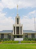
since the 1920s: The Church of England Boys' Home, Church of England Girls' Home, and the Havilah Children's Home, Tress Manning Temporary Care, and Field Cottage. Land owned by the homes has since been developed for housing, with street names such as Trigg, Marella, Carramar, Buckland and Lisgar reflecting the names of individual houses or Anglican Home Mission Society services. Boys' Home buildings and grounds are now the regional base and Sydney Australia Temple
of The Church of Jesus Christ of Latter-day Saints. Girls' Home property in the south of the suburb has become, since 1974, Anglicare's Kingsdene Special School for severely to profoundly intellectually disabled children, as well as the American International School.
As Sydney rapidly expanded, following World War II
, Carlingford underwent rapid urbanisation. James Ruse Agricultural High School, established in 1959, is a testament to the agricultural history of Carlingford as well as the rapid pace of urbanisation; which soon made the school, and its large farm, somewhat of an anomaly amongst the 1970s- and 1980s-style houses which dominate the suburb. More recently, in the 1990s, the government policy of urban consolidation
has seen the development of high-density units and apartment blocks around the town centre and the train station. There have also been redevelopments of older houses into medium-density townhouses, and duplex housing
.
In 1961, the HMS K13
memorial was unveiled, and stands as a prominent feature in Carlingford, passed by thousands of motorists along Pennant Hills Road
each day.
and comprises a shopping strips and two shopping centre
s, Carlingford Court
and Carlingford Village. The shopping strip, near Carlingford railway station, includes Carlingford Bowling Club, the only pub in Carlingford.
Carlingford Court, managed by GPT, is a typical large suburban shopping centre
featuring supermarkets, discount department stores, specialty shops and a Fitness First
. The centre underwent major reconstruction in the late 1990s and underwent minor redevelopment after the Myer
department store closed on March 31, 2006. Carlingford Village is a smaller shopping complex, which has many Asian food outlets.

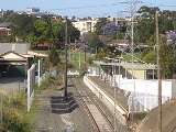
network. The Carlingford Line, which opened on 20 April 1896 as a private railway, then as a public line on 1 August 1901, is a mostly single-track line. There is currently only one service in the early morning which connects to the city directly, at other times a train-change at Clyde
, is necessary to reach other stations, and consequently the service has a low patronage, though it is quite popular during peak hours. As part of the CityRail Clearways Project
, a passing loop was promised to the Carlingford Line with two services per hour all day to become effective in 2010. This was however scrapped in the 2008 mini-budget.
The M2 Hills Motorway, part of the Sydney orbital road, runs through northern Carlingford providing a route to the city and North Sydney
. Since the Westlink M7 Motorway
was finished, completing the Sydney Orbital, it has replaced the Cumberland Highway as the north-south national highway.
The area of Carlingford to the east of Pennant Hills Road and North of Carlingford Road, was built mostly in the years, post WWII. There is an area of streets named after famous North African battle fields. Wattle Place is named for the wattle trees right beside it, on Robbie Crescent, the road that crosses Wattle Place.
, Parramatta
, Eastwood
and Epping
.
Current bus routes operated by Hillsbus operate to various suburbs including Castle Hill
, Baulkham Hills
, Blacktown
and Macquarie Park
.
s.
 As with much of northern Sydney, Carlingford also has a comparatively large number of Christian churches of many denominations. These include:
The Pacific headquarters and Sydney Australia Temple
of The Church of Jesus Christ of Latter-day Saints was constructed in Carlingford in 1984.
A major electricity substation
, operated by Integral Energy
, is located at the corner of Pennant Hills Road and Jenkins Road. The same site also houses one of the major communications relay towers in northern Sydney. The substation previously had a rail siding from the adjacent Carlingford Line; the siding was opened in 1954, and closed in the late 1980s.
data from the 2006 census records the population of Carlingford as 21,365 residents, with 10,682 males and 10,683 females. The median age of people in Carlingford was 39, compared with 37 for the whole of Australia
.
Place of Birth
In the 2006 Census, 86.3% of people living in Carlingford were Australian citizens. 55.1% of people were born in Australia, with 9.4% born in China
, 5.6% in Hong Kong
, 3.2% in the Republic of Korea
, 2.6% in England
and 2.1% in India
.
Languages
In the 2006 Census, 54.4% of people only spoke English
at home, while 14.5% spoke Cantonese, 8.4% spoke Mandarin, 3.9% spoke Korean
, 1.9% spoke Arabic
and 1.2% spoke Tamil
.
Religion
In the 2006 Census, 23.4% of people identify themselves as Catholic
, 19.5% have no religion, 16.5% of people are Anglican
, 5.5% are Buddhists
and 5.3% belong to the Uniting Church
.
in the south, Hornsby Shire
in the north-east, and The Hills Shire in the north-west. Similarly, it falls under several Commonwealth
(Berowra
, Bennelong
, Parramatta
) and State
(Epping
, Baulkham Hills, Parramatta
, The Hills
) electoral divisions/districts.
Carlingford is the most populous suburb within The Hills Shire Council's East Ward and it elected two Liberal Councillors (Clr Andrew Jefferies and Clr Larry Bolitho) and one ALP Councillor at the September 2008 elections. Councillors elected from Hornsby Shire
in C Ward (containing Carlingford) have generally been of a conservative nature. Most of the electoral divisions that Carlingford lies within have historically been held by the Liberal Party of Australia
. The exception is the electoral division and district of Parramatta which include sections south of the Parramatta River, making the overall seats more marginal in nature.
The Commonwealth Electoral Divisions of Berowra
, currently held by the Hon. Philip Ruddock
MP is a safe Liberal
seat. The Commonwealth Electoral Division of Bennelong
, recently lost by Maxine McKew
MP was a marginal ALP
seat. It is now in possession of the Australian Liberal Party. The Commonwealth Electoral Division of Parramatta, currently held by Ms Julie Owens
MP is also a marginal ALP held division.
The State Electoral Districts of Baulkham Hills, currently held by Mr Wayne Merton MLA; Epping, currently held by Greg Smith MLA; and The Hills
, currently held by Shadow Environment Minister Mr Michael Richardson MLA; are safe Liberal
seats. The State Electoral District of Parramatta
, currently held by Ms Tanya Gadiel MLA.
Suburb
The word suburb mostly refers to a residential area, either existing as part of a city or as a separate residential community within commuting distance of a city . Some suburbs have a degree of administrative autonomy, and most have lower population density than inner city neighborhoods...
of Sydney
Sydney
Sydney is the most populous city in Australia and the state capital of New South Wales. Sydney is located on Australia's south-east coast of the Tasman Sea. As of June 2010, the greater metropolitan area had an approximate population of 4.6 million people...
, in the state of New South Wales
New South Wales
New South Wales is a state of :Australia, located in the east of the country. It is bordered by Queensland, Victoria and South Australia to the north, south and west respectively. To the east, the state is bordered by the Tasman Sea, which forms part of the Pacific Ocean. New South Wales...
, Australia
Australia
Australia , officially the Commonwealth of Australia, is a country in the Southern Hemisphere comprising the mainland of the Australian continent, the island of Tasmania, and numerous smaller islands in the Indian and Pacific Oceans. It is the world's sixth-largest country by total area...
. Carlingford is located 22 kilometres north-west of the Sydney central business district
Sydney central business district
The Sydney central business district is the main commercial centre of Sydney, New South Wales, Australia. It extends southwards for about 3 kilometres from Sydney Cove, the point of first European settlement. Its north–south axis runs from Circular Quay in the north to Central railway station in...
in the local government areas of the The Hills Shire, Hornsby Shire
Hornsby Shire
Hornsby Shire is a Local Government Area in the Northern region of Sydney, Australia. The Shire stretches from the suburb of Eastwood in the south to the Hawkesbury River town of Wisemans Ferry, some to the north...
and the City of Parramatta
City of Parramatta
The City of Parramatta is a Local Government Area in western Sydney, in the state of New South Wales, Australia.Initially in 1861 it was formed as Municipality of Parramatta...
. Carlingford is on the north-eastern outskirts of the Greater Western Sydney
Greater Western Sydney
Greater Western Sydney is a term used to describe the western region of the metropolitan area of Sydney, Australia. The University of Western Sydney defines Greater Western Sydney as comprising 14 local government areas...
region and is on the south-eastern outskirts of the Hills District
Hills District (Sydney)
Hills District or The Hills is a general term for the north-western suburbs of Sydney, in the state of New South Wales, Australia. The Hills District is also referred to as The Sydney Hills and The Hills Shire...
and western outskirts of Northern Suburbs
Northern Suburbs (Sydney)
The Northern Suburbs is a general term used to describe the metropolitan area on the northern bank of the Parramatta River in Sydney, New South Wales, Australia east of West Pennant Hills and west of the Lane Cove National Park, south of Hornsby...
.
History
Originally, the area of Carlingford was called Mobbs Hill, named after the ex-convict settler William Mobbs, who is credited for bringing orangeOrange (fruit)
An orange—specifically, the sweet orange—is the citrus Citrus × sinensis and its fruit. It is the most commonly grown tree fruit in the world....
s to Australia. Carlingford received its current name in 1886 after a vote by the residents. The name was suggested by Frederick Cox after he heard one of his employees describe similarities between Mobbs Hill and the town of Carlingford, County Louth
Carlingford, County Louth
Carlingford is a coastal town and townland in northern County Louth, Ireland. It is situated between Carlingford Lough and Slieve Foy, sometimes known as Carlingford Mountain...
, located in the east of Ireland
Ireland
Ireland is an island to the northwest of continental Europe. It is the third-largest island in Europe and the twentieth-largest island on Earth...
. Carlingford in Ireland derived its name from Scandinavian origins, from the time of the Viking
Viking
The term Viking is customarily used to refer to the Norse explorers, warriors, merchants, and pirates who raided, traded, explored and settled in wide areas of Europe, Asia and the North Atlantic islands from the late 8th to the mid-11th century.These Norsemen used their famed longships to...
invasions and settlements. Carlingford may also have been named in honour of Lord Carlingford
Chichester Parkinson-Fortescue, 1st Baron Carlingford
Chichester Samuel Parkinson-Fortescue, 2nd Baron Clermont and 1st Baron Carlingford KP, PC , known as Chichester Fortescue until 1863 and as Chichester Parkinson-Fortescue between 1863 and 1874, Lord Carlingford from 1874 to 1887 and Lord Clermont after 1887, was a British statesman and Liberal...
, who was Under-secretary to the Colonies.
The area was settled in the mid-1800s and, at the time, was an agricultural
Agriculture
Agriculture is the cultivation of animals, plants, fungi and other life forms for food, fiber, and other products used to sustain life. Agriculture was the key implement in the rise of sedentary human civilization, whereby farming of domesticated species created food surpluses that nurtured the...
area on the outskirts of Sydney. Like much of the Hills District, Carlingford was a significant orange-growing area for the city. Pennant Hills Road
Pennant Hills Road
Pennant Hills Road is a major highway located in Sydney, New South Wales. It runs from the suburb of Wahroonga, in the north, to the major central business district of Parramatta, Australia.-History:...
, then a major arterial road from Parramatta to the northern suburbs, was a major route of transportation for agricultural produce from the area. When the train line which terminated at Carlingford railway station, then known as Simpson's Railway, was completed in 1896, it too, became a major route for the area. Carlingford Produce, a gardening and agricultural-materials seller located next to the train station, is located in the former train workshops. This store, much like James Ruse Agricultural High School (see below) remain as testament to the agricultural history of the suburb.
In April 1923 the Wesley Central Mission
Wesley Mission
Wesley Mission is a name used by several Uniting Church congregations which are a part the Uniting Missions Network of UnitingCare Australia. Wesley Missions grew out of the inner city missions of the pre-union Methodist Church of Australasia...
established the Dalmar Children's Homes on 15 acres (60,702.9 m²) of land near Marsden Road in the eastern end of the suburb. The property eventually had many cottages, together with a hospital, an orchard and vegetable gardens. The land is now the site of the Alan Walker Retirement Village.
The suburb was also home to several homes for children operated by the Anglican Diocese of Sydney
Anglican Diocese of Sydney
The Diocese of Sydney is a diocese within the Anglican Church of Australia. The majority of the diocese is Evangelical and low church in tradition and committed to Reformed and Calvinist theology....
since the 1920s: The Church of England Boys' Home, Church of England Girls' Home, and the Havilah Children's Home, Tress Manning Temporary Care, and Field Cottage. Land owned by the homes has since been developed for housing, with street names such as Trigg, Marella, Carramar, Buckland and Lisgar reflecting the names of individual houses or Anglican Home Mission Society services. Boys' Home buildings and grounds are now the regional base and Sydney Australia Temple
Sydney Australia Temple
The Sydney Australia Temple is the 30th constructed and 28th operating temple of The Church of Jesus Christ of Latter-day Saints.-Construction and dedication:...
of The Church of Jesus Christ of Latter-day Saints. Girls' Home property in the south of the suburb has become, since 1974, Anglicare's Kingsdene Special School for severely to profoundly intellectually disabled children, as well as the American International School.
As Sydney rapidly expanded, following World War II
World War II
World War II, or the Second World War , was a global conflict lasting from 1939 to 1945, involving most of the world's nations—including all of the great powers—eventually forming two opposing military alliances: the Allies and the Axis...
, Carlingford underwent rapid urbanisation. James Ruse Agricultural High School, established in 1959, is a testament to the agricultural history of Carlingford as well as the rapid pace of urbanisation; which soon made the school, and its large farm, somewhat of an anomaly amongst the 1970s- and 1980s-style houses which dominate the suburb. More recently, in the 1990s, the government policy of urban consolidation
Urban consolidation
Urban consolidation refers to a diverse set of planning policies intended to make better use of existing urban infrastructure by encouraging development within existing urbanised areas rather than on non-urbanised land , thus limiting urban sprawl...
has seen the development of high-density units and apartment blocks around the town centre and the train station. There have also been redevelopments of older houses into medium-density townhouses, and duplex housing
Semi-detached
Semi-detached housing consists of pairs of houses built side by side as units sharing a party wall and usually in such a way that each house's layout is a mirror image of its twin...
.
In 1961, the HMS K13
HMS K13
HMS K13 was a steam-propelled First World War K class submarine of the British Royal Navy. She sank in a fatal accident during sea trials in early 1917 and was salvaged and recommissioned as HMS K22....
memorial was unveiled, and stands as a prominent feature in Carlingford, passed by thousands of motorists along Pennant Hills Road
Pennant Hills Road
Pennant Hills Road is a major highway located in Sydney, New South Wales. It runs from the suburb of Wahroonga, in the north, to the major central business district of Parramatta, Australia.-History:...
each day.
Commercial areas
The Carlingford town centre is located on Pennant Hills RoadPennant Hills Road
Pennant Hills Road is a major highway located in Sydney, New South Wales. It runs from the suburb of Wahroonga, in the north, to the major central business district of Parramatta, Australia.-History:...
and comprises a shopping strips and two shopping centre
Shopping mall
A shopping mall, shopping centre, shopping arcade, shopping precinct or simply mall is one or more buildings forming a complex of shops representing merchandisers, with interconnecting walkways enabling visitors to easily walk from unit to unit, along with a parking area — a modern, indoor version...
s, Carlingford Court
Carlingford Court
Carlingford Court is a major shopping centre located in Carlingford, a north-western suburb of Sydney, New South Wales, Australia.Carlingford Court has been managed and fully owned by GPT since July 1996...
and Carlingford Village. The shopping strip, near Carlingford railway station, includes Carlingford Bowling Club, the only pub in Carlingford.
Carlingford Court, managed by GPT, is a typical large suburban shopping centre
Shopping mall
A shopping mall, shopping centre, shopping arcade, shopping precinct or simply mall is one or more buildings forming a complex of shops representing merchandisers, with interconnecting walkways enabling visitors to easily walk from unit to unit, along with a parking area — a modern, indoor version...
featuring supermarkets, discount department stores, specialty shops and a Fitness First
Fitness First
Fitness First is the largest privately owned health club group in the world with over 540 Fitness First clubs worldwide reaching over 1.7 million members in 21 countries...
. The centre underwent major reconstruction in the late 1990s and underwent minor redevelopment after the Myer
Myer
Myer is Australia's largest department store chain, retailing a broad range of merchandise including women's, men's and children's clothing, footwear and accessories; cosmetics and fragrance; homewares; electrical; furniture and bedding; toys; books and stationery; food and confectionery; and...
department store closed on March 31, 2006. Carlingford Village is a smaller shopping complex, which has many Asian food outlets.
Transport
As with much of Sydney, Carlingford has relatively limited public transport access, which is reflected in the low public transport patronage by commuters. In the 2001 census, 6% of commuters travelled to work via trains while 2% used buses.Railway
Carlingford railway station is the terminus of the Carlingford Line on the CityRailCityRail
CityRail is an operating brand of RailCorp, a corporation owned by the state government of New South Wales, Australia. It is responsible for providing commuter rail services, and some coach services, in and around Sydney, Newcastle and Wollongong, the three largest cities of New South Wales. It is...
network. The Carlingford Line, which opened on 20 April 1896 as a private railway, then as a public line on 1 August 1901, is a mostly single-track line. There is currently only one service in the early morning which connects to the city directly, at other times a train-change at Clyde
Clyde, New South Wales
Clyde is a suburb of Sydney, in the state of New South Wales, Australia. Clyde is located 21 kilometres west of the Sydney central business district in the local government area of the City of Parramatta...
, is necessary to reach other stations, and consequently the service has a low patronage, though it is quite popular during peak hours. As part of the CityRail Clearways Project
CityRail Clearways Project
The CityRail Clearways Project is a $1.8 billion program of public works on Sydney's CityRail suburban railway network to "untangle" the excessively intertwined and complicated rail network...
, a passing loop was promised to the Carlingford Line with two services per hour all day to become effective in 2010. This was however scrapped in the 2008 mini-budget.
Roads
Because of the limited public transport most residents travel to work by cars. In the 2001 census, 60% stated their main method of getting to work was driving their own vehicle. The Cumberland Highway, a major north-south route through greater Sydney, intersects Carlingford in the form of Pennant Hills Road. As well, many motorists commuting from the Hills District and the growing north-west areas of Sydney travel through Carlingford to the city.The M2 Hills Motorway, part of the Sydney orbital road, runs through northern Carlingford providing a route to the city and North Sydney
North Sydney, New South Wales
North Sydney is a suburb and commercial district on the Lower North Shore of Sydney, in the state of New South Wales, Australia. North Sydney is located 3 kilometres north of the Sydney central business district and is the administrative centre for the local government area of North Sydney...
. Since the Westlink M7 Motorway
Westlink M7
Westlink M7 - formerly Western Sydney Orbital - is one of Sydney, Australia's urban motorways and a part of Metroad 7 and the Sydney Orbital Network. It connects three Metroads: M5 at Prestons, M4 at Eastern Creek and M2 at Baulkham Hills...
was finished, completing the Sydney Orbital, it has replaced the Cumberland Highway as the north-south national highway.
The area of Carlingford to the east of Pennant Hills Road and North of Carlingford Road, was built mostly in the years, post WWII. There is an area of streets named after famous North African battle fields. Wattle Place is named for the wattle trees right beside it, on Robbie Crescent, the road that crosses Wattle Place.
Buses
Buses are the main form of public transport to/from Carlingford. Current bus routes operated by Sydney Buses operate to various suburbs including West RydeWest Ryde, New South Wales
West Ryde is a suburb of Sydney, in the state of New South Wales, Australia. West Ryde is located 16 kilometres north-west of the Sydney central business district, in the local government area of the City of Ryde and is part of the Northern Suburbs area....
, Parramatta
Parramatta, New South Wales
Parramatta is a suburb of Sydney, in the state of New South Wales, Australia. It is located in Greater Western Sydney west of the Sydney central business district on the banks of the Parramatta River. Parramatta is the administrative seat of the Local Government Area of the City of Parramatta...
, Eastwood
Eastwood, New South Wales
Eastwood is a suburb of Sydney, in the state of New South Wales, Australia. Eastwood is located 17 kilometres north-west of the Sydney central business district in the local government areas of the City of Ryde and the City of Parramatta...
and Epping
Epping, New South Wales
Epping is a suburb of Sydney, in the state of New South Wales, Australia. Epping is located 18 kilometres north-west of the Sydney central business district in the local government areas of the City of Ryde, the City of Parramatta and Hornsby Shire and is located in the Northern...
.
Current bus routes operated by Hillsbus operate to various suburbs including Castle Hill
Castle Hill, New South Wales
Castle Hill is a suburb in the north-west of Sydney, in the state of New South Wales, Australia. Castle Hill is located 31 kilometres north-west of the Sydney central business district, in the Hills District of the Greater Western Sydney region...
, Baulkham Hills
Baulkham Hills, New South Wales
Baulkham Hills is a suburb in the north-west of Sydney, in the state of New South Wales, Australia. Baulkham Hills is located 31 kilometres north-west of the Sydney central business district in the local government area of The Hills Shire...
, Blacktown
Blacktown, New South Wales
Blacktown is a suburb in the City of Blacktown, in Western Sydney, in the state of New South Wales, Australia. Blacktown is located 34 kilometres west of the Sydney central business district and is the administrative centre of the local government area of City of Blacktown.Blacktown is the largest...
and Macquarie Park
Macquarie Park, New South Wales
Macquarie Park is a suburb in northern Sydney, in the state of New South Wales, Australia. Macquarie Park is located 12 kilometres north-west of the Sydney central business district in the local government area of the City of Ryde...
.
Schools
Carlingford is the location of a large number of public and private schoolPrivate school
Private schools, also known as independent schools or nonstate schools, are not administered by local, state or national governments; thus, they retain the right to select their students and are funded in whole or in part by charging their students' tuition, rather than relying on mandatory...
s.
- AIS The International School, Sydney (previously American International School)
- Carlingford High SchoolCarlingford High SchoolCarlingford High School is a government high school located in Carlingford, Sydney, New South Wales, Australia.-History:The decision to build a new high school at North Carlingford was made in early 1967...
- Carlingford Public School
- Carlingford West Public School
- Cumberland High SchoolCumberland High School (Carlingford)Cumberland High School is a co-educational comprehensive secondary school located in the north-western metropolitan Western Sydney region of New South Wales, Australia.- History :...
- James Ruse Agricultural High SchoolJames Ruse Agricultural High SchoolJames Ruse Agricultural High School is one of four New South Wales Government agricultural high schools. It is a selective, co-educational public high school located at Carlingford, New South Wales, Australia...
(selective) - Murray Farm Public School
- Roselea Public School
- St Gerard's Primary Catholic School
- Tara Anglican School for Girls
Churches
- Carlingford Baptist Church
- Carlingford Uniting Church
- Marsden Road Uniting Church
- St. Gerard Majella Catholic Church
- St. Paul's Anglican Church
- Iglesia Ni CristoIglesia ni CristoIglesia ni Cristo also known as INC, is the largest entirely indigenous Christian religious organization that originated from the Philippines and the largest independent church in Asia. Due to a number of similarities, some Protestant writers describe the INC's doctrines as restorationist in...
- Christian City ChurchChristian City ChurchesC3 Church Global, formerly known as Christian City Church International , is a Charismatic church movement founded by Pastors Phil Pringle and Christine Pringle. The first church was established at Dee Why on the Northern Beaches of Sydney, Australia, and is now located in Oxford Falls...
, Carlingford - Parramatta City Presbyterian Church
The Pacific headquarters and Sydney Australia Temple
Sydney Australia Temple
The Sydney Australia Temple is the 30th constructed and 28th operating temple of The Church of Jesus Christ of Latter-day Saints.-Construction and dedication:...
of The Church of Jesus Christ of Latter-day Saints was constructed in Carlingford in 1984.
Sport
Carlingford has many sporting clubs participating in many different sports, and at many locations around the Hills District including:- Carlingford Baseball
- Carlingford Netball Club (NetSetGo accredited)
- Redbacks Football Club Formerly Carlingford Redbacks Soccer Club
- Carlingford Cricket
- North Rocks Soccer Club
- Carlingford United Football Club
- Carlingford Comets Netball Club
- Roselea Football Club
- Roselea Ladybirds Netball Club
Services
The Carlingford telephone exchange is located at 413 North Rocks Rd. It serves telephony for Carlingford and nearby suburbs such as Dundas Valley, Telopea and North Rocks.A major electricity substation
Electrical substation
A substation is a part of an electrical generation, transmission, and distribution system. Substations transform voltage from high to low, or the reverse, or perform any of several other important functions...
, operated by Integral Energy
Integral Energy
Integral Energy is the second largest state-owned energy corporation in New South Wales, incorporated under the Energy Services Corporations Act 1995 from a merger between Prospect Electricity and Illawarra Electricity...
, is located at the corner of Pennant Hills Road and Jenkins Road. The same site also houses one of the major communications relay towers in northern Sydney. The substation previously had a rail siding from the adjacent Carlingford Line; the siding was opened in 1954, and closed in the late 1980s.
Demographics
Australian Bureau of StatisticsAustralian Bureau of Statistics
The Australian Bureau of Statistics is Australia's national statistical agency. It was created as the Commonwealth Bureau of Census and Statistics on 8 December 1905, when the Census and Statistics Act 1905 was given Royal assent. It had its beginnings in section 51 of the Constitution of Australia...
data from the 2006 census records the population of Carlingford as 21,365 residents, with 10,682 males and 10,683 females. The median age of people in Carlingford was 39, compared with 37 for the whole of Australia
Australia
Australia , officially the Commonwealth of Australia, is a country in the Southern Hemisphere comprising the mainland of the Australian continent, the island of Tasmania, and numerous smaller islands in the Indian and Pacific Oceans. It is the world's sixth-largest country by total area...
.
Place of Birth
In the 2006 Census, 86.3% of people living in Carlingford were Australian citizens. 55.1% of people were born in Australia, with 9.4% born in China
People's Republic of China
China , officially the People's Republic of China , is the most populous country in the world, with over 1.3 billion citizens. Located in East Asia, the country covers approximately 9.6 million square kilometres...
, 5.6% in Hong Kong
Hong Kong
Hong Kong is one of two Special Administrative Regions of the People's Republic of China , the other being Macau. A city-state situated on China's south coast and enclosed by the Pearl River Delta and South China Sea, it is renowned for its expansive skyline and deep natural harbour...
, 3.2% in the Republic of Korea
South Korea
The Republic of Korea , , is a sovereign state in East Asia, located on the southern portion of the Korean Peninsula. It is neighbored by the People's Republic of China to the west, Japan to the east, North Korea to the north, and the East China Sea and Republic of China to the south...
, 2.6% in England
England
England is a country that is part of the United Kingdom. It shares land borders with Scotland to the north and Wales to the west; the Irish Sea is to the north west, the Celtic Sea to the south west, with the North Sea to the east and the English Channel to the south separating it from continental...
and 2.1% in India
India
India , officially the Republic of India , is a country in South Asia. It is the seventh-largest country by geographical area, the second-most populous country with over 1.2 billion people, and the most populous democracy in the world...
.
Languages
In the 2006 Census, 54.4% of people only spoke English
English language
English is a West Germanic language that arose in the Anglo-Saxon kingdoms of England and spread into what was to become south-east Scotland under the influence of the Anglian medieval kingdom of Northumbria...
at home, while 14.5% spoke Cantonese, 8.4% spoke Mandarin, 3.9% spoke Korean
Korean language
Korean is the official language of the country Korea, in both South and North. It is also one of the two official languages in the Yanbian Korean Autonomous Prefecture in People's Republic of China. There are about 78 million Korean speakers worldwide. In the 15th century, a national writing...
, 1.9% spoke Arabic
Arabic language
Arabic is a name applied to the descendants of the Classical Arabic language of the 6th century AD, used most prominently in the Quran, the Islamic Holy Book...
and 1.2% spoke Tamil
Tamil language
Tamil is a Dravidian language spoken predominantly by Tamil people of the Indian subcontinent. It has official status in the Indian state of Tamil Nadu and in the Indian union territory of Pondicherry. Tamil is also an official language of Sri Lanka and Singapore...
.
Religion
In the 2006 Census, 23.4% of people identify themselves as Catholic
Roman Catholic Church
The Catholic Church, also known as the Roman Catholic Church, is the world's largest Christian church, with over a billion members. Led by the Pope, it defines its mission as spreading the gospel of Jesus Christ, administering the sacraments and exercising charity...
, 19.5% have no religion, 16.5% of people are Anglican
Anglicanism
Anglicanism is a tradition within Christianity comprising churches with historical connections to the Church of England or similar beliefs, worship and church structures. The word Anglican originates in ecclesia anglicana, a medieval Latin phrase dating to at least 1246 that means the English...
, 5.5% are Buddhists
Buddhism
Buddhism is a religion and philosophy encompassing a variety of traditions, beliefs and practices, largely based on teachings attributed to Siddhartha Gautama, commonly known as the Buddha . The Buddha lived and taught in the northeastern Indian subcontinent some time between the 6th and 4th...
and 5.3% belong to the Uniting Church
Uniting Church in Australia
The Uniting Church in Australia was formed on 22 June 1977 when many congregations of the Methodist Church of Australasia, the Presbyterian Church of Australia and the Congregational Union of Australia came together under the Basis of Union....
.
Politics
Carlingford falls under the jurisdiction of three Local Government Areas: the City of ParramattaCity of Parramatta
The City of Parramatta is a Local Government Area in western Sydney, in the state of New South Wales, Australia.Initially in 1861 it was formed as Municipality of Parramatta...
in the south, Hornsby Shire
Hornsby Shire
Hornsby Shire is a Local Government Area in the Northern region of Sydney, Australia. The Shire stretches from the suburb of Eastwood in the south to the Hawkesbury River town of Wisemans Ferry, some to the north...
in the north-east, and The Hills Shire in the north-west. Similarly, it falls under several Commonwealth
Australia
Australia , officially the Commonwealth of Australia, is a country in the Southern Hemisphere comprising the mainland of the Australian continent, the island of Tasmania, and numerous smaller islands in the Indian and Pacific Oceans. It is the world's sixth-largest country by total area...
(Berowra
Division of Berowra
The Division of Berowra is an Australian Electoral Division in New South Wales. The division was created in 1969 and is named for the suburb of Berowra. Its boundaries have changed little since it was created, and it includes all or parts of the suburbs of Arcadia, Berowra, Brooklyn, Cheltenham,...
, Bennelong
Division of Bennelong
The Division of Bennelong is an Australian electorate in New South Wales. The division was created in 1949 and is named for Bennelong, an Aboriginal man befriended by the first Governor of New South Wales, Arthur Phillip...
, Parramatta
Division of Parramatta
The Division of Parramatta is an Australian Electoral Division in New South Wales. The division was created in 1900 and was one of the original 75 divisions contested at the first federal election. It is named for the locality of Parramatta. The name Parramatta has been sourced to an Aboriginal...
) and State
New South Wales
New South Wales is a state of :Australia, located in the east of the country. It is bordered by Queensland, Victoria and South Australia to the north, south and west respectively. To the east, the state is bordered by the Tasman Sea, which forms part of the Pacific Ocean. New South Wales...
(Epping
Electoral district of Epping
Epping is an electoral district of the Legislative Assembly in the Australian state of New South Wales. It is represented by Greg Smith of the Liberal Party of Australia.-Members for Epping:-Election results:...
, Baulkham Hills, Parramatta
Electoral district of Parramatta
Parramatta is an electoral district of the Legislative Assembly in the Australian state of New South Wales. It is currently held by Geoff Lee of the Liberal Party of Australia....
, The Hills
Electoral district of The Hills
The Hills was an electoral district of the Legislative Assembly in the Australian state of New South Wales from 1962 to 2007. It was a 51.08 km² urban electorate in Sydney's north-west, taking in the suburbs of Carlingford, Castle Hill, Cherrybrook, Glenhaven, Kellyville, Pennant Hills and West...
) electoral divisions/districts.
Carlingford is the most populous suburb within The Hills Shire Council's East Ward and it elected two Liberal Councillors (Clr Andrew Jefferies and Clr Larry Bolitho) and one ALP Councillor at the September 2008 elections. Councillors elected from Hornsby Shire
Hornsby Shire
Hornsby Shire is a Local Government Area in the Northern region of Sydney, Australia. The Shire stretches from the suburb of Eastwood in the south to the Hawkesbury River town of Wisemans Ferry, some to the north...
in C Ward (containing Carlingford) have generally been of a conservative nature. Most of the electoral divisions that Carlingford lies within have historically been held by the Liberal Party of Australia
Liberal Party of Australia
The Liberal Party of Australia is an Australian political party.Founded a year after the 1943 federal election to replace the United Australia Party, the centre-right Liberal Party typically competes with the centre-left Australian Labor Party for political office...
. The exception is the electoral division and district of Parramatta which include sections south of the Parramatta River, making the overall seats more marginal in nature.
The Commonwealth Electoral Divisions of Berowra
Division of Berowra
The Division of Berowra is an Australian Electoral Division in New South Wales. The division was created in 1969 and is named for the suburb of Berowra. Its boundaries have changed little since it was created, and it includes all or parts of the suburbs of Arcadia, Berowra, Brooklyn, Cheltenham,...
, currently held by the Hon. Philip Ruddock
Philip Ruddock
Philip Maxwell Ruddock is an Australian politician who is currently a member of the House of Representatives representing the Division of Berowra, New South Wales, for the Liberal Party of Australia...
MP is a safe Liberal
Liberal Party of Australia
The Liberal Party of Australia is an Australian political party.Founded a year after the 1943 federal election to replace the United Australia Party, the centre-right Liberal Party typically competes with the centre-left Australian Labor Party for political office...
seat. The Commonwealth Electoral Division of Bennelong
Division of Bennelong
The Division of Bennelong is an Australian electorate in New South Wales. The division was created in 1949 and is named for Bennelong, an Aboriginal man befriended by the first Governor of New South Wales, Arthur Phillip...
, recently lost by Maxine McKew
Maxine McKew
Maxine Margaret McKew , is a former Australian politician and journalist; she was the Parliamentary Secretary for Infrastructure, Transport, Regional Development and Local Government in the Rudd Ministry and the First Gillard Ministry. Between 2007 and 2010, she was the member of the House of...
MP was a marginal ALP
Australian Labor Party
The Australian Labor Party is an Australian political party. It has been the governing party of the Commonwealth of Australia since the 2007 federal election. Julia Gillard is the party's federal parliamentary leader and Prime Minister of Australia...
seat. It is now in possession of the Australian Liberal Party. The Commonwealth Electoral Division of Parramatta, currently held by Ms Julie Owens
Julie Owens
Julie Ann Owens , Australian politician, has been an Australian Labor Party member of the Australian House of Representatives since October 2004, representing the division of Parramatta, New South Wales...
MP is also a marginal ALP held division.
The State Electoral Districts of Baulkham Hills, currently held by Mr Wayne Merton MLA; Epping, currently held by Greg Smith MLA; and The Hills
Electoral district of The Hills
The Hills was an electoral district of the Legislative Assembly in the Australian state of New South Wales from 1962 to 2007. It was a 51.08 km² urban electorate in Sydney's north-west, taking in the suburbs of Carlingford, Castle Hill, Cherrybrook, Glenhaven, Kellyville, Pennant Hills and West...
, currently held by Shadow Environment Minister Mr Michael Richardson MLA; are safe Liberal
Liberal Party of Australia
The Liberal Party of Australia is an Australian political party.Founded a year after the 1943 federal election to replace the United Australia Party, the centre-right Liberal Party typically competes with the centre-left Australian Labor Party for political office...
seats. The State Electoral District of Parramatta
Electoral district of Parramatta
Parramatta is an electoral district of the Legislative Assembly in the Australian state of New South Wales. It is currently held by Geoff Lee of the Liberal Party of Australia....
, currently held by Ms Tanya Gadiel MLA.