

Central railway station, Sydney
Encyclopedia
Central Railway Station, the largest railway station in Australia
, is at the southern end of the Sydney CBD. It services almost all the lines on the CityRail
network, and is the major terminus for interurban and interstate rail services. Central Statiion houses the operations of The Rail Corporation New South Wales
, it sits beside Railway Square
, is officially located in Haymarket
, and is the station closest to the University of Technology Sydney at Broadway.
The original Sydney Station was opened on 26 September 1855 in an area known as "Cleveland Fields." This station (one wooden platform in a corrugated iron shed), called Redfern, had Devonshire Street as its northern boundary.
When this station became inadequate for the traffic
it carried, a new station was built in 1874 on the same site and also called Redfern. This was a brick building with two platforms. It grew to 14 platforms before it was replaced by the present-day station to the north of Devonshire Street. The new station was built on a site previously occupied by the Devonshire Street Cemetery, a convent, a female refuge, a police barracks, a parsonage and a Benevolent Society. The remains exhumed from the cemetery were re-interred at a number of other Sydney cemeteries including Rookwood Cemetery
and Waverley Cemetery
. Bodies were moved to Botany by steam tram motors and flat cars. The new 15-platform station, still in use, opened on 4 August 1906, and included the previous Mortuary railway station used to transport funeral parties to Rookwood Cemetery
.
The last train departed platform 5 of the 1874 station at midnight. During the remainder of that night the passenger concourse was demolished and the line extended through the old station into the new station. The Western Mail train that arrived in Sydney at 5:50am on 5 August 1906 arrived at the new station. Devonshire Street, which separated the two stations, became a pedestrian
underpass to allow people to cross the railway line and is now known by many as the Devonshire Street Tunnel.
Sydney station has expanded since 1906 in an easterly direction. A 75-metre clock tower in the Free Classical style was added at the north-western corner of the station, opened in 3 March 1921. Central Station was designed by the Government Architect, Walter Liberty Vernon
, and has been described as the "grandest railway station in Australia." It is listed on the Register of the National Estate
.
A riot, dubbed the Battle of Central Station
, took place in 1916. Soldiers rebelling against camp conditions had raided hotels in Liverpool
and travelled to the city by commandeered trains. Upon arrival at Central Station the rioters set about destroying the station facilities, and fire was exchanged between rampaging rioters and military police
. One rioter was shot dead and several were injured. The only remaining evidence of the gun battle is a small bullet-hole in the marble by the entrance to platform 1. This incident had a direct influence on the introduction of 6 o'clock closing
of hotels in 1916, which lasted in New South Wales until 1955.
Central Station celebrated its 100th birthday on 5 August 2006, with preserved steam locomotives providing shuttle trips from Sydney to Hurstville and Railmotor rides from Mortuary Station to Flemington goods yards.
 In the days of steam, the station was regarded as being divided into "steam" and "electric" parts.
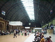
The western ("steam") half, known as Sydney Terminal, comprises 15 terminal platforms and was opened in 1906. This section is dominated by a large vaulted roof over the concourse and elaborate masonry
, primarily sandstone
, the most common rock in the Sydney region. This section is popularly known as the country platforms, even though only three platforms are commonly used for long-distance trains: most of the platforms are used for CityRail intercity services.
To the west of Platform 1 there was a siding leading to two dock platforms for use of mail trains, now cut back to serve a car loading ramp for the Indian Pacific. The space where the mail sidings were is now a youth hostel. The hostel rooms are modelled on old train carriages.
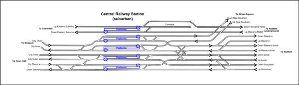
The eastern ("suburban" or "electric") part of Central Station, formerly known as 'Central Electric', consists of 12 through platforms, all aligned north-south, four of which are underground, used by suburban CityRail
services and by a limited number of intercity services during peak hours. The eight above-ground platforms were opened in 1926 as part of a large electrification
and modernisation program aimed at improving Sydney's suburban railway services.
The four underground platforms
were built as part of the Eastern Suburbs Railway. Construction commenced in 1948 but the Eastern Suburbs line was not finished until 1979. While the plans called for four platforms, two (for the Southern Suburbs line) were found to be not needed and are used for archival storage by the New South Wales Railways.
and interstate passenger trains operated by the State-owned CountryLink
and the famous Indian Pacific, the twice-weekly train between Sydney
and Perth
, Western Australia
, terminate at Central.
The platforms are numbered from 1 to 27, with 1 being the westernmost platform and 27 being one of the easternmost. The services which generally use each platform are listed below.
The station is served by twenty-seven to thirty-eight trains per hour in each direction, with additional trains during weekday peak hours.
CityRail
and CountryLink services are listed on the box:
line, which runs for 7.2 km to Lilyfield. It is the only station on the light rail line where transfer to CityRail
services is possible.
The light rail stop is in an outside concourse area, near the main waiting area and departure hall. This area was originally designed for trams, and was used by such until 1958, when the service was withdrawn. It was known as "Railway Colonnade"
. It allows easy transfer from trains to Chinatown
, Darling Harbour, Pyrmont
and the inner western suburbs. Tickets that can be used on the Metro Light Rail include MyMulti
tickets, Pensioner Excursion, Family Funday Sunday and TramLink cards which combines travel with Cityrail
. Single Tickets are also available.
. Special bus services depart from Chalmers Street, such as replacement services for CityRail trains due to track work, or free shuttle services to special events at Moore Park, like rugby or cricket.
Buses for the University of New South Wales
leave Stand D on Eddy Avenue, returning to the station side of Eddy Avenue. Express buses (Route 891) to the University of New South Wales arrive approximately every two minutes during morning peak hours, with decreasing frequency in off-peak hours.
A large number of Sydney Buses services offer interchange from Central. They are:
Stand A NightRide
Services:
Stand B (Northern Beaches Services):
Stand C (Inner West Services):
Stand C NightRide
Services:
Stand D (South West Services to Newtown):
Stand C:
Stand D:
Australia
Australia , officially the Commonwealth of Australia, is a country in the Southern Hemisphere comprising the mainland of the Australian continent, the island of Tasmania, and numerous smaller islands in the Indian and Pacific Oceans. It is the world's sixth-largest country by total area...
, is at the southern end of the Sydney CBD. It services almost all the lines on the CityRail
CityRail
CityRail is an operating brand of RailCorp, a corporation owned by the state government of New South Wales, Australia. It is responsible for providing commuter rail services, and some coach services, in and around Sydney, Newcastle and Wollongong, the three largest cities of New South Wales. It is...
network, and is the major terminus for interurban and interstate rail services. Central Statiion houses the operations of The Rail Corporation New South Wales
Rail Corporation New South Wales
Rail Corporation New South Wales is a statutory authority of the New South Wales government. RailCorp owns, operates and maintains the Sydney suburban and interurban rail network which is marketed under the CityRail brand; in addition to operating rural passenger services under the CountryLink...
, it sits beside Railway Square
Railway Square, Sydney
The area is not a true square but is a confluence of Broadway, Lee Street, Pitt Street and George Street. The University of Technology, Central railway station and the now closed Kent Brewery are adjacent to Railway Square.-History:...
, is officially located in Haymarket
Haymarket, New South Wales
Haymarket is a locality of Sydney's city centre, New South Wales, Australia. It is located at the southern end of the Sydney central business district in the local government area of the City of Sydney....
, and is the station closest to the University of Technology Sydney at Broadway.
History
There have been three terminal stations in Sydney.The original Sydney Station was opened on 26 September 1855 in an area known as "Cleveland Fields." This station (one wooden platform in a corrugated iron shed), called Redfern, had Devonshire Street as its northern boundary.
When this station became inadequate for the traffic
Traffic
Traffic on roads may consist of pedestrians, ridden or herded animals, vehicles, streetcars and other conveyances, either singly or together, while using the public way for purposes of travel...
it carried, a new station was built in 1874 on the same site and also called Redfern. This was a brick building with two platforms. It grew to 14 platforms before it was replaced by the present-day station to the north of Devonshire Street. The new station was built on a site previously occupied by the Devonshire Street Cemetery, a convent, a female refuge, a police barracks, a parsonage and a Benevolent Society. The remains exhumed from the cemetery were re-interred at a number of other Sydney cemeteries including Rookwood Cemetery
Rookwood Cemetery
Rookwood Cemetery is the largest multicultural necropolis in the Southern Hemisphere, located in Sydney, New South Wales, Australia...
and Waverley Cemetery
Waverley Cemetery
The Waverley Cemetery opened in 1877 and is a cemetery located on top of the cliffs at Bronte in the eastern suburbs of Sydney. It is noted for its largely intact Victorian and Edwardian monuments. The cemetery contains the graves of many significant Australians including the poet Henry Lawson and...
. Bodies were moved to Botany by steam tram motors and flat cars. The new 15-platform station, still in use, opened on 4 August 1906, and included the previous Mortuary railway station used to transport funeral parties to Rookwood Cemetery
Rookwood Cemetery
Rookwood Cemetery is the largest multicultural necropolis in the Southern Hemisphere, located in Sydney, New South Wales, Australia...
.
The last train departed platform 5 of the 1874 station at midnight. During the remainder of that night the passenger concourse was demolished and the line extended through the old station into the new station. The Western Mail train that arrived in Sydney at 5:50am on 5 August 1906 arrived at the new station. Devonshire Street, which separated the two stations, became a pedestrian
Pedestrian
A pedestrian is a person traveling on foot, whether walking or running. In some communities, those traveling using roller skates or skateboards are also considered to be pedestrians. In modern times, the term mostly refers to someone walking on a road or footpath, but this was not the case...
underpass to allow people to cross the railway line and is now known by many as the Devonshire Street Tunnel.
Sydney station has expanded since 1906 in an easterly direction. A 75-metre clock tower in the Free Classical style was added at the north-western corner of the station, opened in 3 March 1921. Central Station was designed by the Government Architect, Walter Liberty Vernon
Walter Liberty Vernon
Walter Liberty Vernon was an English architect who migrated to the state of New South Wales, Australia and pursued his career as an architect in Sydney...
, and has been described as the "grandest railway station in Australia." It is listed on the Register of the National Estate
Register of the National Estate
The Register of the National Estate is a listing of natural and cultural heritage places in Australia. The listing was initially compiled between 1976 and 2003 by the Australian Heritage Commission. The register is now maintained by the Australian Heritage Council...
.
A riot, dubbed the Battle of Central Station
Liverpool riot of 1916
The Liverpool Riot of 1916 also known as the Battle of Central Station was an event in Sydney, Australia where a large group of Australian soldiers rioted through the streets of Sydney and surrounding areas....
, took place in 1916. Soldiers rebelling against camp conditions had raided hotels in Liverpool
Liverpool, New South Wales
Liverpool is a suburb in south-western Sydney, in the state of New South Wales, Australia. Liverpool is located 32 km south-west of the Sydney central business district, and is the administrative centre of the local government area of the City of Liverpool...
and travelled to the city by commandeered trains. Upon arrival at Central Station the rioters set about destroying the station facilities, and fire was exchanged between rampaging rioters and military police
Military police
Military police are police organisations connected with, or part of, the military of a state. The word can have different meanings in different countries, and may refer to:...
. One rioter was shot dead and several were injured. The only remaining evidence of the gun battle is a small bullet-hole in the marble by the entrance to platform 1. This incident had a direct influence on the introduction of 6 o'clock closing
Six o'clock swill
The six o'clock swill was an Australian and New Zealand slang term for the last-minute rush to buy drinks at a hotel bar before it closed. During a significant part of the 20th century, most Australian and New Zealand hotels shut their public bars at 6 p.m. A culture developed of heavy drinking...
of hotels in 1916, which lasted in New South Wales until 1955.
Central Station celebrated its 100th birthday on 5 August 2006, with preserved steam locomotives providing shuttle trips from Sydney to Hurstville and Railmotor rides from Mortuary Station to Flemington goods yards.
Station configuration
The western ("steam") half, known as Sydney Terminal, comprises 15 terminal platforms and was opened in 1906. This section is dominated by a large vaulted roof over the concourse and elaborate masonry
Masonry
Masonry is the building of structures from individual units laid in and bound together by mortar; the term masonry can also refer to the units themselves. The common materials of masonry construction are brick, stone, marble, granite, travertine, limestone; concrete block, glass block, stucco, and...
, primarily sandstone
Sydney sandstone
Sydney sandstone is the common name for Sydney Basin Hawkesbury Sandstone, historically known as Yellowblock, is a sedimentary rock named after the Hawkesbury River north of Sydney, where this sandstone is particularly common....
, the most common rock in the Sydney region. This section is popularly known as the country platforms, even though only three platforms are commonly used for long-distance trains: most of the platforms are used for CityRail intercity services.
To the west of Platform 1 there was a siding leading to two dock platforms for use of mail trains, now cut back to serve a car loading ramp for the Indian Pacific. The space where the mail sidings were is now a youth hostel. The hostel rooms are modelled on old train carriages.
The eastern ("suburban" or "electric") part of Central Station, formerly known as 'Central Electric', consists of 12 through platforms, all aligned north-south, four of which are underground, used by suburban CityRail
CityRail
CityRail is an operating brand of RailCorp, a corporation owned by the state government of New South Wales, Australia. It is responsible for providing commuter rail services, and some coach services, in and around Sydney, Newcastle and Wollongong, the three largest cities of New South Wales. It is...
services and by a limited number of intercity services during peak hours. The eight above-ground platforms were opened in 1926 as part of a large electrification
Electrification
Electrification originally referred to the build out of the electrical generating and distribution systems which occurred in the United States, England and other countries from the mid 1880's until around 1940 and is in progress in developing countries. This also included the change over from line...
and modernisation program aimed at improving Sydney's suburban railway services.
The four underground platforms
Railway platform
A railway platform is a section of pathway, alongside rail tracks at a train station, metro station or tram stop, at which passengers may board or alight from trains or trams. Almost all stations for rail transport have some form of platforms, with larger stations having multiple platforms...
were built as part of the Eastern Suburbs Railway. Construction commenced in 1948 but the Eastern Suburbs line was not finished until 1979. While the plans called for four platforms, two (for the Southern Suburbs line) were found to be not needed and are used for archival storage by the New South Wales Railways.
Service and platforms
Central Station serves all suburban lines except for the Cumberland Line, and all intercity lines except for the Hunter Line. All long-distance ruralRural
Rural areas or the country or countryside are areas that are not urbanized, though when large areas are described, country towns and smaller cities will be included. They have a low population density, and typically much of the land is devoted to agriculture...
and interstate passenger trains operated by the State-owned CountryLink
CountryLink
CountryLink is the operator of passenger rail services in country New South Wales, Australia and into Queensland and Victoria. It is an operating brand of the Rail Corporation New South Wales, a government-owned entity...
and the famous Indian Pacific, the twice-weekly train between Sydney
Sydney
Sydney is the most populous city in Australia and the state capital of New South Wales. Sydney is located on Australia's south-east coast of the Tasman Sea. As of June 2010, the greater metropolitan area had an approximate population of 4.6 million people...
and Perth
Perth, Western Australia
Perth is the capital and largest city of the Australian state of Western Australia and the fourth most populous city in Australia. The Perth metropolitan area has an estimated population of almost 1,700,000....
, Western Australia
Western Australia
Western Australia is a state of Australia, occupying the entire western third of the Australian continent. It is bounded by the Indian Ocean to the north and west, the Great Australian Bight and Indian Ocean to the south, the Northern Territory to the north-east and South Australia to the south-east...
, terminate at Central.
The platforms are numbered from 1 to 27, with 1 being the westernmost platform and 27 being one of the easternmost. The services which generally use each platform are listed below.
The station is served by twenty-seven to thirty-eight trains per hour in each direction, with additional trains during weekday peak hours.
CityRail
CityRail
CityRail is an operating brand of RailCorp, a corporation owned by the state government of New South Wales, Australia. It is responsible for providing commuter rail services, and some coach services, in and around Sydney, Newcastle and Wollongong, the three largest cities of New South Wales. It is...
and CountryLink services are listed on the box:
Trackplan
Light rail
Central station is the location of Central light rail stop, the eastern terminus of the Metro Light RailMetro Light Rail
The Metro Light Rail is the only currently operating light rail line in Sydney. The line opened on 31 August 1997, mostly along the route of an unused goods railway line, to serve the redeveloped inner-city areas of Darling Harbour, Ultimo and Pyrmont, and was extended in 2000 to serve some of...
line, which runs for 7.2 km to Lilyfield. It is the only station on the light rail line where transfer to CityRail
CityRail
CityRail is an operating brand of RailCorp, a corporation owned by the state government of New South Wales, Australia. It is responsible for providing commuter rail services, and some coach services, in and around Sydney, Newcastle and Wollongong, the three largest cities of New South Wales. It is...
services is possible.
The light rail stop is in an outside concourse area, near the main waiting area and departure hall. This area was originally designed for trams, and was used by such until 1958, when the service was withdrawn. It was known as "Railway Colonnade"
Trams in Sydney
The Sydney tramway network once served Sydney, the capital city of New South Wales, Australia. In its heyday, it was the largest in Australia, the second largest in the Commonwealth , and one of the largest in the world. It was extremely intensively worked, with about 1,600 cars in service at any...
. It allows easy transfer from trains to Chinatown
Chinatown, Sydney
Sydney's Chinatown is an urban locality in the southern part of the Sydney central business district, in New South Wales, Australia. It is located in Haymarket, between Central Station and Darling Harbour...
, Darling Harbour, Pyrmont
Pyrmont, New South Wales
Pyrmont is an inner-city suburb of Sydney, in the state of New South Wales, Australia. Pyrmont is located 2 kilometres south-west of the Sydney central business district in the local government area of the City of Sydney...
and the inner western suburbs. Tickets that can be used on the Metro Light Rail include MyMulti
MyZone
MyZone is a public transport fare structure in the Greater Sydney area of New South Wales, Australia. It covers transport on CityRail trains, the publicly-owned Sydney Buses network, private buses, and the publicly-owned Sydney Ferries network throughout the Sydney metropolitan area, as well as in...
tickets, Pensioner Excursion, Family Funday Sunday and TramLink cards which combines travel with Cityrail
CityRail
CityRail is an operating brand of RailCorp, a corporation owned by the state government of New South Wales, Australia. It is responsible for providing commuter rail services, and some coach services, in and around Sydney, Newcastle and Wollongong, the three largest cities of New South Wales. It is...
. Single Tickets are also available.
Bus services
Many bus services depart from the adjacent Eddy Avenue and Chalmers Street or from the nearby Railway Square on George StreetGeorge Street, Sydney
George Street is one of Sydney's most notable city streets. There are more high rise buildings and more ASX 100 companies located here than anywhere else in Australia, and is well known for being busy around-the-clock...
. Special bus services depart from Chalmers Street, such as replacement services for CityRail trains due to track work, or free shuttle services to special events at Moore Park, like rugby or cricket.
Buses for the University of New South Wales
University of New South Wales
The University of New South Wales , is a research-focused university based in Kensington, a suburb in Sydney, New South Wales, Australia...
leave Stand D on Eddy Avenue, returning to the station side of Eddy Avenue. Express buses (Route 891) to the University of New South Wales arrive approximately every two minutes during morning peak hours, with decreasing frequency in off-peak hours.
A large number of Sydney Buses services offer interchange from Central. They are:
Railway Square (George Street)
Stand A (Eastern Suburbs Services):- 305 - to MascotMascot, New South WalesMascot is a suburb in south-eastern Sydney, in the state of New South Wales, Australia. Mascot is located 7 kilometres south of the Sydney central business district and is the administrative centre of the City of Botany Bay...
- (O`Riordan Street near Baxter Road) - 309 - to Port BotanyPort Botany, New South WalesPort Botany is a suburb in south-eastern Sydney, in the state of New South Wales, Australia. Port Botany is located 12 kilometres south-east of the Sydney central business district, is in the local government area of the City of Randwick...
- (Port Botany Depot, Monday-Saturday morning only) - 310 - to EastgardensEastgardens, New South WalesEastgardens is a suburb in the Eastern Suburbs of Sydney, specifically south-eastern Sydney, in the state of New South Wales, Australia. Eastgardens is located 9km south east of the Sydney central business district and is part of the City of Botany Bay....
- (Westfield bus interchange, Monday-Saturday morning only) - 311 - to Gresham Street via WoolloomoollooWoolloomooloo, New South WalesWoolloomooloo is a harbourside, inner-city eastern suburb of Sydney, in the state of New South Wales, Australia. Woolloomooloo is located 1.5 kilometres east of the Sydney central business district, in the local government area of the City of Sydney. The suburb is located in a low-lying, former...
- 372 - to CoogeeCoogee, New South WalesCoogee is a beachside suburb of local government area City of Randwick. It is located 8 kilometres south-east of the Sydney central business district, in the state of New South Wales, Australia. It is also a part of the Eastern Suburbs of Sydney....
- (Arden Street near Dolphin Street) - 378 - to Bronte BeachBronte BeachBronte Beach is a small but popular recreational beach on Nelson Bay in Bronte in the eastern suburbs of Sydney, Australia. Bronte beach is 2 kilometers south of Bondi Beach and north of the much larger Coogee Beach. A long distance ocean swimming event is held every December between Bondi Beach...
- (Bronte Beach Terminus) - 393 - to Little BayLittle Bay, New South WalesLittle Bay is a suburb in south-eastern Sydney, in the state of New South Wales, Australia. Little Bay is located 14 kilometres south-east of the Sydney central business district and is part of the local government area of the City of Randwick....
- (Anzac Parade near Little Bay Road) - 395 - to Maroubra BeachMaroubra, New South WalesMaroubra is a beachside suburb in the Eastern Suburbs of Sydney, in the state of New South Wales, Australia. Maroubra is located 10 kilometres south-east of the Sydney central business district in the local government area of the City of Randwick. Maroubra is the largest suburb in the area governed...
- (Maroubra Beach set down only)
Stand A NightRide
NightRide
NightRide is a network of bus routes in operation between midnight and 5.00 am in Sydney, Australia. The eleven routes are run by private bus operators and allow for a nightly shutdown of the CityRail commuter rail network. Established by the New South Wales Ministry of Transport and monitored by...
Services:
- N100 - to Bondi Junction
Stand B (Northern Beaches Services):
- E86 - to Church PointChurch Point, New South WalesChurch Point is a suburb in northern Sydney, in the state of New South Wales, Australia. Church Point is located 32 kilometres north of the Sydney central business district, in the local government area of Pittwater Council and is part of the Northern Beaches region.-History:Thomas Langford was the...
- (Mccarrs Creek Terminus) - E87 - to NewportNewport, New South WalesNewport is a suburb in northern Sydney, in the state of New South Wales, Australia. Newport is located 31 kilometres north of the Sydney central business district, in the local government area of Pittwater Council, and is part of the Northern Beaches region....
- (Seaview Avenue near Robertson Road) - L88 - to AvalonAvalon, New South WalesAvalon is a northern beachside suburb of Sydney, in the state of New South Wales, Australia. Avalon is located 35 kilometres north of the Sydney central business district, in the local government area of Pittwater Council, in the Northern Beaches region....
- (Carreel Head Road near Burrawong Road) - E88 - to AvalonAvalon, New South WalesAvalon is a northern beachside suburb of Sydney, in the state of New South Wales, Australia. Avalon is located 35 kilometres north of the Sydney central business district, in the local government area of Pittwater Council, in the Northern Beaches region....
- (Barrenjoey Road near Careel Head Road) - E89 - to AvalonAvalon, New South WalesAvalon is a northern beachside suburb of Sydney, in the state of New South Wales, Australia. Avalon is located 35 kilometres north of the Sydney central business district, in the local government area of Pittwater Council, in the Northern Beaches region....
- (Barrenjoey Road near Avalon Parade) - 190 - to Palm BeachPalm Beach, New South WalesPalm Beach is a northern beachside suburb of Sydney, in the state of New South Wales, Australia. Palm Beach is located 41 kilometres north of the Sydney central business district, in the local government area of Pittwater Council, in the Northern Beaches region. Palm Beach sits on a peninsula at...
- (Ocean Place near Ocean Road) - L90 - to Palm BeachPalm Beach, New South WalesPalm Beach is a northern beachside suburb of Sydney, in the state of New South Wales, Australia. Palm Beach is located 41 kilometres north of the Sydney central business district, in the local government area of Pittwater Council, in the Northern Beaches region. Palm Beach sits on a peninsula at...
- (Ocean Place near Ocean Road)
Stand C (Inner West Services):
- 412 - to CampsieCampsie, New South WalesCampsie is a suburb in south-western Sydney, in the state of New South Wales, Australia. Campsie is located 13 kilometres south-west of the Sydney central business district, on the southern bank of the Cooks River. Campsie is the commercial and administrative centre of the City of...
- (South Parade) - 413 - to CampsieCampsie, New South WalesCampsie is a suburb in south-western Sydney, in the state of New South Wales, Australia. Campsie is located 13 kilometres south-west of the Sydney central business district, on the southern bank of the Cooks River. Campsie is the commercial and administrative centre of the City of...
- (Beamish Street near North Parade) - 431 - to Glebe PointGlebe Point, New South WalesGlebe Point is a locality in the suburb of Glebe, in the Inner West of Sydney, in the state of New South Wales, Australia.- External links :*...
- (Federal Road Terminus) - 433 - to BalmainBalmain, New South WalesBalmain is a suburb in the inner-west of Sydney, in the state of New South Wales, Australia. Balmain is located slightly west of the Sydney central business district, in the local government area of the Municipality of Leichhardt....
- (Darling Street near Curtis Road) - 437 - to Five DockFive Dock, New South WalesFive Dock is a suburb in the inner-west of Sydney, in the state of New South Wales, Australia. Five Dock is located 10 kilometres west of the Sydney central business district, in the Local Government Area of the City of Canada Bay.-Location:...
- (Great North Road) - 438 - to AbbotsfordAbbotsford, New South WalesAbbotsford is a suburb in the Inner West region of Sydney, in the state of New South Wales, Australia. Abbotsford is located 10 kilometres west of the Sydney central business district in the local government area of the City of Canada Bay...
- (Great North Road and The Terrace) - L38 - to AbbotsfordAbbotsford, New South WalesAbbotsford is a suburb in the Inner West region of Sydney, in the state of New South Wales, Australia. Abbotsford is located 10 kilometres west of the Sydney central business district in the local government area of the City of Canada Bay...
(Great North Road and The Terrace) - 439 - to MortlakeMortlake, New South WalesMortlake is a suburb in the inner-west of Sydney, in the state of New South Wales, Australia. Mortlake is located 17 kilometres west of the Sydney central business district, in the local government area of the City of Canada Bay.-Transport:...
- L39 - to MortlakeMortlake, New South WalesMortlake is a suburb in the inner-west of Sydney, in the state of New South Wales, Australia. Mortlake is located 17 kilometres west of the Sydney central business district, in the local government area of the City of Canada Bay.-Transport:...
- 440 - to RozelleRozelle, New South WalesRozelle is a suburb in the inner west of Sydney, in the state of New South Wales, Australia. It is located 4 kilometres west of the Sydney central business district, in the local government area of the Municipality of Leichhardt....
- (Terry Street near Victoria Road) - 461 - to BurwoodBurwood, New South WalesBurwood is a suburb in the inner-west of Sydney, in the state of New South Wales, Australia. Burwood is located 12 kilometres west of the Sydney central business district and is the administrative centre for the local government area of Burwood Council....
- (Railway Parade near Burwood Plaza) - M10 - to LeichhardtLeichhardt, New South WalesLeichhardt is a suburb in the inner-west of Sydney in New South Wales, Australia. Leichhardt is located 5 kilometres west of the Sydney central business district and is the administrative centre for the local government area of the Municipality of Leichhardt...
- (Pioneers Memorial Park) - 480 - to StrathfieldStrathfield, New South WalesStrathfield is an Inner West suburb of Sydney, in the state of New South Wales, Australia. Strathfield is located 14 kilometres west of the Sydney central business district and is the administrative centre of the local government area of the Municipality of Strathfield...
- (Strathfield Station via Homebush Road) - 483 - to StrathfieldStrathfield, New South WalesStrathfield is an Inner West suburb of Sydney, in the state of New South Wales, Australia. Strathfield is located 14 kilometres west of the Sydney central business district and is the administrative centre of the local government area of the Municipality of Strathfield...
- (Strathfield Station via Strathfield Girls' High School)
Stand C NightRide
NightRide
NightRide is a network of bus routes in operation between midnight and 5.00 am in Sydney, Australia. The eleven routes are run by private bus operators and allow for a nightly shutdown of the CityRail commuter rail network. Established by the New South Wales Ministry of Transport and monitored by...
Services:
- N10 - to Sutherland
- N11 - to Cronulla
- N30 - to Macarthur
- N40 - to East Hills
- N50 - to Liverpool
- N60 - to FairfieldFairfield railway station, Sydney-Bus services:Fairfield Bus InterchangeWestbus:*824 - to Wakeley.*825 - weekdays and Saturday services - to Greenfield Park*826 - weekdays and Saturday services - to Cabramatta...
- N61 - to Carlingford
- N70 - to PenrithPenrith railway station, SydneyPenrith railway station is a railway station on the CityRail network in New South Wales, Australia. Located in the Sydney suburb of Penrith, the station serves as a major interchange between Western line, Blue Mountains line trains. Western-bound CountryLink XPT and Xplorer services also stop here...
- N71 - to Richmond
- N80 - to Hornsby
Stand D (South West Services to Newtown):
- M30 - to SydenhamSydenham, New South WalesFor other places called Sydenham, see Sydenham .Sydenham is a small suburb in the inner-west of Sydney, in the state of New South Wales, Australia. Sydenham is located 8 kilometres south of Sydney central business district and is part of the local government area of Marrickville Council...
- 422 - to KogarahKogarah, New South WalesKogarah is a suburb of southern Sydney, in the state of New South Wales, Australia. Kogarah is located 14 kilometres south of the Sydney central business district and is considered to be the centre of the St George area...
- 423 - to KingsgroveKingsgrove, New South WalesKingsgrove is a suburb in southern Sydney, in the state of New South Wales, Australia. Kingsgrove is located 13 kilometres south of the Sydney central business district and lies across the local government areas of the City of Rockdale, the City of Hurstville and the City of Canterbury...
- L23 - to KingsgroveKingsgrove, New South WalesKingsgrove is a suburb in southern Sydney, in the state of New South Wales, Australia. Kingsgrove is located 13 kilometres south of the Sydney central business district and lies across the local government areas of the City of Rockdale, the City of Hurstville and the City of Canterbury...
- 426 - to Dulwich HillDulwich Hill, New South WalesDulwich Hill is a residential suburb in the Inner West of Sydney, in the state of New South Wales, Australia. Dulwich Hill is located 9 kilometres south-west of the Sydney central business district, in the local government area of Marrickville Council...
- 428 - to CanterburyCanterbury, New South Wales-Commercial area:Canterbury has a mixture of residential, commercial and industrial developments. Commercial developments are mostly situated on Canterbury Road and surrounding streets...
- L28 - to CanterburyCanterbury, New South Wales-Commercial area:Canterbury has a mixture of residential, commercial and industrial developments. Commercial developments are mostly situated on Canterbury Road and surrounding streets...
Central Station (Eddy Avenue)
Stand A:- 311 - to Gresham Street via WoolloomoolooWoolloomooloo, New South WalesWoolloomooloo is a harbourside, inner-city eastern suburb of Sydney, in the state of New South Wales, Australia. Woolloomooloo is located 1.5 kilometres east of the Sydney central business district, in the local government area of the City of Sydney. The suburb is located in a low-lying, former...
- 378 - to Bronte BeachBronte BeachBronte Beach is a small but popular recreational beach on Nelson Bay in Bronte in the eastern suburbs of Sydney, Australia. Bronte beach is 2 kilometers south of Bondi Beach and north of the much larger Coogee Beach. A long distance ocean swimming event is held every December between Bondi Beach...
- (Bronte Beach Terminus)
Stand C:
- 339 - to ClovellyClovelly, New South WalesClovelly is a small beach-side suburb in Sydney's eastern suburbs, in the state of New South Wales, Australia. Clovelly is located 8 kilometres south-east of the Sydney central business district, in the local government area of the City of Randwick, within the Federal Division of Wentworth.Clovelly...
- (Clovelly Road Terminus) - 372 - to CoogeeCoogee, New South WalesCoogee is a beachside suburb of local government area City of Randwick. It is located 8 kilometres south-east of the Sydney central business district, in the state of New South Wales, Australia. It is also a part of the Eastern Suburbs of Sydney....
- (Arden Street near Dolphin Street) - 374 - to CoogeeCoogee, New South WalesCoogee is a beachside suburb of local government area City of Randwick. It is located 8 kilometres south-east of the Sydney central business district, in the state of New South Wales, Australia. It is also a part of the Eastern Suburbs of Sydney....
- (Arden Street near Dolphin Street) - 376 - to Maroubra BeachMaroubra, New South WalesMaroubra is a beachside suburb in the Eastern Suburbs of Sydney, in the state of New South Wales, Australia. Maroubra is located 10 kilometres south-east of the Sydney central business district in the local government area of the City of Randwick. Maroubra is the largest suburb in the area governed...
- (Maroubra Beach set down only) - 391 - to Port BotanyPort Botany, New South WalesPort Botany is a suburb in south-eastern Sydney, in the state of New South Wales, Australia. Port Botany is located 12 kilometres south-east of the Sydney central business district, is in the local government area of the City of Randwick...
- (Port Botany Terminus); to La PerouseLa Perouse, New South WalesLapérouse is a suburb in south-eastern Sydney, in the state of New South Wales, Australia. The suburb of Lapérouse is located about 14 kilometres south-east of the Sydney central business district, in the City of Randwick....
(Anzac Parade Terminus) - 393 - to Little BayLittle Bay, New South WalesLittle Bay is a suburb in south-eastern Sydney, in the state of New South Wales, Australia. Little Bay is located 14 kilometres south-east of the Sydney central business district and is part of the local government area of the City of Randwick....
- (Anzac Parade near Little Bay Road) - 395 - to Maroubra BeachMaroubra, New South WalesMaroubra is a beachside suburb in the Eastern Suburbs of Sydney, in the state of New South Wales, Australia. Maroubra is located 10 kilometres south-east of the Sydney central business district in the local government area of the City of Randwick. Maroubra is the largest suburb in the area governed...
- (Maroubra Beach set down only)
Stand D:
- 309 - to Port BotanyPort Botany, New South WalesPort Botany is a suburb in south-eastern Sydney, in the state of New South Wales, Australia. Port Botany is located 12 kilometres south-east of the Sydney central business district, is in the local government area of the City of Randwick...
- (Port Botany Depot, Monday-Saturday morning only) - 310 - to EastgardensEastgardens, New South WalesEastgardens is a suburb in the Eastern Suburbs of Sydney, specifically south-eastern Sydney, in the state of New South Wales, Australia. Eastgardens is located 9km south east of the Sydney central business district and is part of the City of Botany Bay....
- (Westfield bus interchange,Monday-Saturday morning only) - 891 - to University of New South WalesUniversity of New South WalesThe University of New South Wales , is a research-focused university based in Kensington, a suburb in Sydney, New South Wales, Australia...
- (High Street near Botany Street) - 892 - to University of New South WalesUniversity of New South WalesThe University of New South Wales , is a research-focused university based in Kensington, a suburb in Sydney, New South Wales, Australia...
- (High Street near Botany Street)
Hillsbus services to the Hills District depart from Pitt Street
- M61 - to Castle HillCastle Hill, New South WalesCastle Hill is a suburb in the north-west of Sydney, in the state of New South Wales, Australia. Castle Hill is located 31 kilometres north-west of the Sydney central business district, in the Hills District of the Greater Western Sydney region...
via Express via Lane Cove TunnelLane Cove TunnelThe Lane Cove Tunnel is a A$1.1 billion, 3.6 km twin tunnel tollway in Sydney, Australia, connecting the M2 Motorway at North Ryde with the Gore Hill Freeway at Artarmon. It forms part of Sydney Metroad 2 and the 110 km Sydney Orbital Network...
, M2M2 Hills MotorwayThe M2 Hills Motorway is a motorway in north-western Sydney, New South Wales, Australia. It forms part of Sydney Metroad 2 and the 110 km Sydney Orbital Network. West of Pennant Hills Road, the M2 is also part of the National Highway.-History:Previously, Sydney's western suburbs were poorly served...
& Baulkham HillsBaulkham Hills, New South WalesBaulkham Hills is a suburb in the north-west of Sydney, in the state of New South Wales, Australia. Baulkham Hills is located 31 kilometres north-west of the Sydney central business district in the local government area of The Hills Shire... - 610 - to Rouse Hill Town CentreRouse Hill, New South WalesRouse Hill is a suburb of Sydney, in the state of New South Wales, Australia. Rouse Hill is located 42 kilometres north-west of the Sydney central business district in the local government area of The Hills Shire...
via M2M2 Hills MotorwayThe M2 Hills Motorway is a motorway in north-western Sydney, New South Wales, Australia. It forms part of Sydney Metroad 2 and the 110 km Sydney Orbital Network. West of Pennant Hills Road, the M2 is also part of the National Highway.-History:Previously, Sydney's western suburbs were poorly served...
, Baulkham HillsBaulkham Hills, New South WalesBaulkham Hills is a suburb in the north-west of Sydney, in the state of New South Wales, Australia. Baulkham Hills is located 31 kilometres north-west of the Sydney central business district in the local government area of The Hills Shire... - 610X - to Rouse Hill Town CentreRouse Hill, New South WalesRouse Hill is a suburb of Sydney, in the state of New South Wales, Australia. Rouse Hill is located 42 kilometres north-west of the Sydney central business district in the local government area of The Hills Shire...
via Express via Lane Cove TunnelLane Cove TunnelThe Lane Cove Tunnel is a A$1.1 billion, 3.6 km twin tunnel tollway in Sydney, Australia, connecting the M2 Motorway at North Ryde with the Gore Hill Freeway at Artarmon. It forms part of Sydney Metroad 2 and the 110 km Sydney Orbital Network...
, M2M2 Hills MotorwayThe M2 Hills Motorway is a motorway in north-western Sydney, New South Wales, Australia. It forms part of Sydney Metroad 2 and the 110 km Sydney Orbital Network. West of Pennant Hills Road, the M2 is also part of the National Highway.-History:Previously, Sydney's western suburbs were poorly served...
& Baulkham HillsBaulkham Hills, New South WalesBaulkham Hills is a suburb in the north-west of Sydney, in the state of New South Wales, Australia. Baulkham Hills is located 31 kilometres north-west of the Sydney central business district in the local government area of The Hills Shire... - 613 - to Bella VistaBella Vista, New South WalesBella Vista is a suburb of north-western Sydney, in the state of New South Wales, Australia. Bella Vista is located 33 kilometres west of the Sydney central business district, in the local government area of the The Hills Shire. Bella Vista is part of the Greater Western Sydney region and the Hills...
via M2M2 Hills MotorwayThe M2 Hills Motorway is a motorway in north-western Sydney, New South Wales, Australia. It forms part of Sydney Metroad 2 and the 110 km Sydney Orbital Network. West of Pennant Hills Road, the M2 is also part of the National Highway.-History:Previously, Sydney's western suburbs were poorly served... - 613X - to Bella VistaBella Vista, New South WalesBella Vista is a suburb of north-western Sydney, in the state of New South Wales, Australia. Bella Vista is located 33 kilometres west of the Sydney central business district, in the local government area of the The Hills Shire. Bella Vista is part of the Greater Western Sydney region and the Hills...
via Express via Lane Cove TunnelLane Cove TunnelThe Lane Cove Tunnel is a A$1.1 billion, 3.6 km twin tunnel tollway in Sydney, Australia, connecting the M2 Motorway at North Ryde with the Gore Hill Freeway at Artarmon. It forms part of Sydney Metroad 2 and the 110 km Sydney Orbital Network...
, M2M2 Hills MotorwayThe M2 Hills Motorway is a motorway in north-western Sydney, New South Wales, Australia. It forms part of Sydney Metroad 2 and the 110 km Sydney Orbital Network. West of Pennant Hills Road, the M2 is also part of the National Highway.-History:Previously, Sydney's western suburbs were poorly served... - 614 - to CrestwoodCrestwood, New South WalesCrestwood is an urban locality in Sydney, New South Wales, Australia. Crestwood is located in the suburb of Baulkham Hills in the local government area of Baulkham Hills Shire.-Education:*Crestwood High - 7-12 Government Owned...
via M2M2 Hills MotorwayThe M2 Hills Motorway is a motorway in north-western Sydney, New South Wales, Australia. It forms part of Sydney Metroad 2 and the 110 km Sydney Orbital Network. West of Pennant Hills Road, the M2 is also part of the National Highway.-History:Previously, Sydney's western suburbs were poorly served...
, NorthmeadNorthmead, New South WalesNorthmead is a suburb of Sydney, in the state of New South Wales, Australia. Northmead is located 26 kilometres west of the Sydney central business district, in the local government areas of the City of Parramatta and The Hills Shire...
, Winston HillsWinston Hills, New South WalesWinston Hills is a suburb of Sydney, in the state of New South Wales, Australia. Winston Hills is located 28 kilometres west of the Sydney central business district in the local government area of the City of Parramatta and the Greater Western Sydney region.... - 614X - to CrestwoodCrestwood, New South WalesCrestwood is an urban locality in Sydney, New South Wales, Australia. Crestwood is located in the suburb of Baulkham Hills in the local government area of Baulkham Hills Shire.-Education:*Crestwood High - 7-12 Government Owned...
via Express via Lane Cove TunnelLane Cove TunnelThe Lane Cove Tunnel is a A$1.1 billion, 3.6 km twin tunnel tollway in Sydney, Australia, connecting the M2 Motorway at North Ryde with the Gore Hill Freeway at Artarmon. It forms part of Sydney Metroad 2 and the 110 km Sydney Orbital Network...
, M2M2 Hills MotorwayThe M2 Hills Motorway is a motorway in north-western Sydney, New South Wales, Australia. It forms part of Sydney Metroad 2 and the 110 km Sydney Orbital Network. West of Pennant Hills Road, the M2 is also part of the National Highway.-History:Previously, Sydney's western suburbs were poorly served...
, NorthmeadNorthmead, New South WalesNorthmead is a suburb of Sydney, in the state of New South Wales, Australia. Northmead is located 26 kilometres west of the Sydney central business district, in the local government areas of the City of Parramatta and The Hills Shire...
, Winston HillsWinston Hills, New South WalesWinston Hills is a suburb of Sydney, in the state of New South Wales, Australia. Winston Hills is located 28 kilometres west of the Sydney central business district in the local government area of the City of Parramatta and the Greater Western Sydney region.... - 615 - to Riley T-Way Station via M2M2 Hills MotorwayThe M2 Hills Motorway is a motorway in north-western Sydney, New South Wales, Australia. It forms part of Sydney Metroad 2 and the 110 km Sydney Orbital Network. West of Pennant Hills Road, the M2 is also part of the National Highway.-History:Previously, Sydney's western suburbs were poorly served...
, Baulkham HillsBaulkham Hills, New South WalesBaulkham Hills is a suburb in the north-west of Sydney, in the state of New South Wales, Australia. Baulkham Hills is located 31 kilometres north-west of the Sydney central business district in the local government area of The Hills Shire...
, KellyvilleKellyville, New South WalesKellyville is a suburb of Sydney, in the state of New South Wales, Australia. Kellyville is located 36 kilometres north-west of the Sydney central business district in the local government area of The Hills Shire, part of the Hills District region.-History:... - 615X - to Riley T-Way Station via Express via Lane Cove TunnelLane Cove TunnelThe Lane Cove Tunnel is a A$1.1 billion, 3.6 km twin tunnel tollway in Sydney, Australia, connecting the M2 Motorway at North Ryde with the Gore Hill Freeway at Artarmon. It forms part of Sydney Metroad 2 and the 110 km Sydney Orbital Network...
, M2M2 Hills MotorwayThe M2 Hills Motorway is a motorway in north-western Sydney, New South Wales, Australia. It forms part of Sydney Metroad 2 and the 110 km Sydney Orbital Network. West of Pennant Hills Road, the M2 is also part of the National Highway.-History:Previously, Sydney's western suburbs were poorly served...
, Baulkham HillsBaulkham Hills, New South WalesBaulkham Hills is a suburb in the north-west of Sydney, in the state of New South Wales, Australia. Baulkham Hills is located 31 kilometres north-west of the Sydney central business district in the local government area of The Hills Shire...
, KellyvilleKellyville, New South WalesKellyville is a suburb of Sydney, in the state of New South Wales, Australia. Kellyville is located 36 kilometres north-west of the Sydney central business district in the local government area of The Hills Shire, part of the Hills District region.-History:... - 616 - to Rouse Hill Town CentreRouse Hill, New South WalesRouse Hill is a suburb of Sydney, in the state of New South Wales, Australia. Rouse Hill is located 42 kilometres north-west of the Sydney central business district in the local government area of The Hills Shire...
via GlenwoodGlenwood, New South WalesGlenwood is a suburb of Sydney, in the state of New South Wales, Australia. Glenwood is located 40 kilometres west of the Sydney central business district in the local government area of the City of Blacktown...
, Stanhope Gardens - 616X - to Rouse Hill Town CentreRouse Hill, New South WalesRouse Hill is a suburb of Sydney, in the state of New South Wales, Australia. Rouse Hill is located 42 kilometres north-west of the Sydney central business district in the local government area of The Hills Shire...
via Express via Lane Cove TunnelLane Cove TunnelThe Lane Cove Tunnel is a A$1.1 billion, 3.6 km twin tunnel tollway in Sydney, Australia, connecting the M2 Motorway at North Ryde with the Gore Hill Freeway at Artarmon. It forms part of Sydney Metroad 2 and the 110 km Sydney Orbital Network...
, GlenwoodGlenwood, New South WalesGlenwood is a suburb of Sydney, in the state of New South Wales, Australia. Glenwood is located 40 kilometres west of the Sydney central business district in the local government area of the City of Blacktown...
, Stanhope Gardens - 617X - to Rouse Hill Town CentreRouse Hill, New South WalesRouse Hill is a suburb of Sydney, in the state of New South Wales, Australia. Rouse Hill is located 42 kilometres north-west of the Sydney central business district in the local government area of The Hills Shire...
via Express via Lane Cove TunnelLane Cove TunnelThe Lane Cove Tunnel is a A$1.1 billion, 3.6 km twin tunnel tollway in Sydney, Australia, connecting the M2 Motorway at North Ryde with the Gore Hill Freeway at Artarmon. It forms part of Sydney Metroad 2 and the 110 km Sydney Orbital Network...
, North-West T-WayNorth-West T-wayThe North-West T-way is a bus rapid transit line in the north-western suburbs of Sydney, Australia. T-way is short for rapid bus transitway.The T-way consists of two sections, one linking Parramatta railway station and Rouse Hill, the other linking Blacktown and Parklea. The lines intersect at...
, Beaumont HillsBeaumont Hills, New South WalesBeaumont Hills is a suburb of Sydney, in the state of New South Wales, Australia. Beaumont Hills is located 40 kilometres west of the Sydney central business district, in the local government area of the The Hills Shire...
Devonshire Street pedestrian tunnel
After Central Station was built in 1906, Devonshire Street, to the north of the old station, became an underpass. The underpass allows pedestrians to access the eastern "suburban" section from Railway Square and Chalmers Street.Country services
City services
Further reading
External links
- Trainman's Train Page - pictures of unused platforms 26 & 27 (at bottom of page).
- Cityrail's Tour of Central Station - information about specific points of interest in the station.