
West Ryde, New South Wales
Encyclopedia
Suburb
The word suburb mostly refers to a residential area, either existing as part of a city or as a separate residential community within commuting distance of a city . Some suburbs have a degree of administrative autonomy, and most have lower population density than inner city neighborhoods...
of Sydney
Sydney
Sydney is the most populous city in Australia and the state capital of New South Wales. Sydney is located on Australia's south-east coast of the Tasman Sea. As of June 2010, the greater metropolitan area had an approximate population of 4.6 million people...
, in the state of New South Wales
New South Wales
New South Wales is a state of :Australia, located in the east of the country. It is bordered by Queensland, Victoria and South Australia to the north, south and west respectively. To the east, the state is bordered by the Tasman Sea, which forms part of the Pacific Ocean. New South Wales...
, Australia
Australia
Australia , officially the Commonwealth of Australia, is a country in the Southern Hemisphere comprising the mainland of the Australian continent, the island of Tasmania, and numerous smaller islands in the Indian and Pacific Oceans. It is the world's sixth-largest country by total area...
. West Ryde is located 16 kilometres north-west of the Sydney central business district
Sydney central business district
The Sydney central business district is the main commercial centre of Sydney, New South Wales, Australia. It extends southwards for about 3 kilometres from Sydney Cove, the point of first European settlement. Its north–south axis runs from Circular Quay in the north to Central railway station in...
, in the local government area of the City of Ryde
City of Ryde
The City of Ryde is a Local Government Area in Sydney, New South Wales, Australia, on the Lower North Shore and Greater Western Sydney over West Ryde and Eastwood District....
and is part of the Northern Suburbs
Northern Suburbs (Sydney)
The Northern Suburbs is a general term used to describe the metropolitan area on the northern bank of the Parramatta River in Sydney, New South Wales, Australia east of West Pennant Hills and west of the Lane Cove National Park, south of Hornsby...
area.
Ryde
Ryde, New South Wales
Ryde is a suburb of Sydney, New South Wales, Australia. Ryde is located 13 km north-west of the Sydney central business district and 8 km east of Parramatta. Ryde is the administrative centre of the local government area of the City of Ryde and part of the Northern Suburbs area...
, North Ryde
North Ryde, New South Wales
North Ryde is a suburb of Sydney, in the state of New South Wales, Australia. North Ryde is located 15 kilometres north-west of the Sydney central business district, in the local government area of the City of Ryde...
and East Ryde
East Ryde, New South Wales
East Ryde is a suburb in the Northern Suburbs of Sydney, in the state of New South Wales, Australia. East Ryde is located 12 kilometres north-west of the Sydney central business district, in the local government area of the City of Ryde. East Ryde sits on the western bank of the Lane Cove River...
are separate suburbs. The suburbs of Denistone
Denistone, New South Wales
Denistone is a suburb in the Northern Suburbs of Sydney, in the state of New South Wales, Australia. Denistone is located 16 kilometres north-west of the Sydney central business district in the local government area of the City of Ryde...
, Denistone West
Denistone West, New South Wales
Denistone West is a suburb in the Northern Suburbs of Sydney, in the state of New South Wales, Australia. Denistone West is located 16 kilometres north-west of the Sydney central business district in the local government area of the City of Ryde...
, Meadowbank
Meadowbank, New South Wales
Meadowbank is a suburb of Sydney, New South Wales, Australia. Meadowbank is located 15 kilometres west of the Sydney central business district, in the local government area of the City of Ryde and part of the Northern Suburbs area...
and Melrose Park
Melrose Park, New South Wales
Melrose Park is a suburb of Sydney, New South Wales, Australia. Melrose Park is located 17 kilometres north-west of the Sydney central business district, in the local government areas of the City of Ryde and is part of the Northern Suburbs area...
share the 2114 postcode with West Ryde.
History
West Ryde is an extension of RydeRyde, New South Wales
Ryde is a suburb of Sydney, New South Wales, Australia. Ryde is located 13 km north-west of the Sydney central business district and 8 km east of Parramatta. Ryde is the administrative centre of the local government area of the City of Ryde and part of the Northern Suburbs area...
, which was named after the 'Ryde Store', a business run by G.M. Pope. He adopted the name from his birthplace of Ryde
Ryde
Ryde is a British seaside town, civil parish and the most populous town and urban area on the Isle of Wight, with a population of approximately 30,000. It is situated on the north-east coast. The town grew in size as a seaside resort following the joining of the villages of Upper Ryde and Lower...
on the Isle of Wight
Isle of Wight
The Isle of Wight is a county and the largest island of England, located in the English Channel, on average about 2–4 miles off the south coast of the county of Hampshire, separated from the mainland by a strait called the Solent...
, UK.
West Ryde is one of 16 suburbs that form the City of Ryde
City of Ryde
The City of Ryde is a Local Government Area in Sydney, New South Wales, Australia, on the Lower North Shore and Greater Western Sydney over West Ryde and Eastwood District....
. West Ryde is approximately 12 kilometres from the centre of Sydney
Sydney
Sydney is the most populous city in Australia and the state capital of New South Wales. Sydney is located on Australia's south-east coast of the Tasman Sea. As of June 2010, the greater metropolitan area had an approximate population of 4.6 million people...
and occupies most of the land between the Parramatta and Lane Cove rivers. It is bisected from west to east by one of Sydney's busiest roads, Victoria Road
Victoria Road, Sydney
Victoria Road is a major road in Sydney, Australia.Victoria Road connects Parramatta with the Rozelle end of Anzac Bridge. Victoria Road passes through the Sydney suburbs of Rydalmere, Ermington, West Ryde, Ryde, Gladesville and Drummoyne and is currently one of the longest roads in Sydney.The road...
. It is crossed north to south by another main road, Lane Cove Road
Lane Cove Road
Lane Cove Road is a major suburban arterial road in Sydney, Australia. It forms part of Metroad 3 and is located in the Ryde local government area....
, and is skirted on the north-west by the M2 Motorway
M2 motorway
The M2 is a motorway in Kent, England. It is 25.7 miles long and acts as a bypass of the section of the A2 road which runs through the Medway Towns, Sittingbourne and Faversham.- Route :...
and Epping Road
Epping Road
Epping Road , NSW Main Road 28, is an important arterial road in suburban Sydney. Epping Road is 9 kilometres long, and is a major route linking the lower North Shore and Sydney CBD to the north western suburbs and Hills District of metropolitan Sydney...
. At the time of the arrival of Europeans at Sydney Cove
Sydney Cove
Sydney Cove is a small bay on the southern shore of Port Jackson , on the coast of the state of New South Wales, Australia....
in January 1788, the Wallumedegal or Wallumede were the traditional owners of the area and they called it Wallumetta
Wallumetta
Wallumatta was the original name given to the Ryde-Hunters Hill area of the Lower North Shore of Sydney, Australia. Prior to the time that the area was known as Kissing Point, Wallumatta was the formal title and was named in honour of the area's native inhabitants: The Wallumettagal Aboriginal...
. This clan formed part of a large Dharug language group.
Early landholders
Throughout much of the nineteenth century, most of the land in West Ryde, EastwoodEastwood
-Places:in Australia*Eastwood, New South Wales**Eastwood railway station*Eastwood, South Australiain Canada*Eastwood, Ontario*Eastwood, Edmonton, Alberta, a neighborhoodin the Philippines*Eastwood Cityin the UK*Eastwood, Essex, England...
and Denistone was consolidated in a handful of large estates owned by a few of the colonial elites, notably the Blaxland and the Darvall families. Much of the land in this suburb lying to the west of the main northern railway line was originally granted to Dr William Balmain
William Balmain
William Balmain was a British naval surgeon who sailed as an assistant surgeon with the First Fleet to establish the first European settlement in Australia, and later became its principal surgeon.-Early life and career:...
in the mid to late 1790s. Balmain was one of the assistant surgeons on the First Fleet, having sailed on the Alexander. He worked as a magistrate in the colony and, due to the shortage of money at that time, was paid with the labour of convicts to work on his land. However, it is not known how much clearing and cultivation was done during those years. In 1801 Balmain and his family returned to England, where he died in 1803. His heirs were Jane and John Henderson, his children by a convict woman, Margaret Dawson
Margaret Dawson
Margaret Dawson was a convict on the First Fleet sent from Britain to New South Wales in 1787. She had a long-term relationship with the surgeon, William Balmain, and was one of Australia's 'founding mothers' whose descendants still live in Australia and Britain.She came from Liverpool and in...
(Henderson was his mother's maiden name). While they were in England, the land was rented by the explorer Gregory Blaxland
Gregory Blaxland
Gregory Blaxland was a pioneer farmer and explorer in Australia.- Early life :Gregory Blaxland was born 17 June 1778 at Fordwich, Kent, England, the fourth son of John Blaxland, mayor from 1767 to 1774, whose family had owned estates nearby for generations, and Mary, daughter of Captain Parker,...
, who owned nearby Brush Farm. In 1818 the Balmain lands were sold to an ex-convict John Bennett. His nephew William was his heir. Soon after he inherited the land, William married Susan Brown. Initially the couple lived in John's old house which was near the intersection of Bellevue and Bigland avenues, but in 1836 they mortgaged part of their land to build a new house in what is now Meadowbank Park, Meadowbank. Major Edward Darvall and his family arrived in the colony in January 1840. He was a retired English army officer with strong family connections to the British East India Company. His wife Emily came from a long line of wealthy London merchants. In May 1840, the Darvalls leased Deniston Farm and 100 acres (40 hectares) of land from a Dr Forster, for a period of 12 years. However, the property was again advertised to let in the Sydney Morning Herald on 8 March 1849. In 1855 William and Susan Bennett sold all their land north of Victoria Road to Major Darvall. The Darvall property stretched from Shaftsbury Road to Ryedale Road and from Rowe Street to Victoria Road, a total of 360 acres (146 hectares). They built a two-storey house, Ryedale House, during the late 1850s, now the site of St Columb's Anglican Church. The house was constructed of sandstone blocks. It is believed the Ryedale Estate was so named because of its closeness to Ryde and because Major Darvall came from the Yorkshire dales. The 50 acres (20 hectares) nearest the house were planted with orchards, mainly citrus trees. The Darvalls lived in this house for nearly 70 years – Edward until his death in 1869, his widow Jane until 1899, their son Anthony until 1910 and Anthony's widow Kate until 1922.
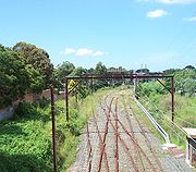
The railway and subdivision
In the 1880s, with the building of the railway line from Homebush to HornsbyHornsby
- Places :* Hornsby, Cumbria, a place in Cumbria, Northern England* Hornsby, New South Wales, suburb of Sydney, Australia** Hornsby Shire, New South Wales, local government area of Sydney...
, some estates were subdivided along its route. Landowners like Mrs Darvall sold parcels of their estates to the colonial government and by 1883 construction was well advanced. The railway bridge across the Parramatta River
Parramatta River
The Parramatta River is a waterway in Sydney, New South Wales, Australia. The Parramatta River is the main tributary of Sydney Harbour, a branch of Port Jackson, along with the smaller Lane Cove and Duck Rivers....
was completed in August 1886 and was followed by the opening of a single line track from Strathfield to Hornsby on 17 September 1886. Ryde (now called West Ryde) was one of the seven stations of this line and one of only two that were built of brick. The new railway platforms at both West Ryde and Eastwood
Eastwood
-Places:in Australia*Eastwood, New South Wales**Eastwood railway station*Eastwood, South Australiain Canada*Eastwood, Ontario*Eastwood, Edmonton, Alberta, a neighborhoodin the Philippines*Eastwood Cityin the UK*Eastwood, Essex, England...
did not service commuters. They were for freight. By the end of the nineteenth century, some Darvall land had been sold, yet the bulk of the Ryedale Estate remained intact. Anthony Darvall started subdividing the land after his mother's death. The first subdivisions were between Clanalpine and Rowe streets (Eastwood) in the north and between Anthony Road and West Parade in the south-east. Eventually Ryedale House and a small parcel of land were sold to the Anglican Church in the 1930s. The house was used as a rectory until the early 1970s when it was bought by private individuals who removed it, stone by stone, and re-erected it on a rural property in the Hunter Valley
Hunter Valley
The Hunter Region, more commonly known as the Hunter Valley, is a region of New South Wales, Australia, extending from approximately to north of Sydney with an approximate population of 645,395 people. Most of the population of the Hunter Region lives within of the coast, with 55% of the entire...
. All that remains at the original site (apart from the old and new churches) is a small group of buildings, one of which is two-storey, with a blank end wall. This was a brick extension added to Ryedale House around 1900, probably when Anthony William and his family took up residence. Other twentieth-century subdivisions proposed included the Ryde New Township Estate in the Falconer and Hermitage Road area in 1906. By 1909 Ryde Heights, which was located on the southern side of Blaxland Road between Benson Lane and Melville Street was advertised as 'the pick of the district – 10 special residential sites for high class houses overlooking the windings of the Parramatta River'. The sixth and last subdivision of the Darvall Estate was the Outlook Estate, in the Denistone area. The 124 homes sites were advertised for private sale in 1929. The houses were built during the 1930s and 1940s.
Naming of West Ryde
Subdivision plans up to 1936 still advertised the railway station in West Ryde as Ryde Railway Station. This had been a source of contention for some time. Owing to the distance from Ryde village and the growth of this new settlement west of Ryde, the use of the term Ryde for the railway station soon became anomalous. In 1908 the Ermington-Rydalmere Council tried unsuccessfully to persuade Ryde aldermen that the name should be ErmingtonErmington
Ermington can refer to:* Ermington House - The residence of Edmund Lockyer in Ermington, AustraliaThere are several places named Ermington:* Ermington, New South Wales - A suburb of Sydney, Australia...
. West Ryde as a locality was gradually evolving. It was officially designated a postal area in October 1926. West Ryde Public School was called Meadowbank until 1930. In 1929 an attempt was made to change the name of the station to West Ryde. This request, reiterated from time to time, was finally granted in October 1945. West Ryde has a busy commercial centre based around Victoria Road and the railway station. The beginnings of a commercial centre here followed the opening of the railway in 1886 and the subdivision of the Meriam Hill Estate on the eastern side of the railway in 1888. The railway hotel was built on the corner of Victoria and Ryedale Roads in 1892 and a handful of shops established themselves nearby in the following decade. West Ryde's shopping centre was transformed in the 1950s, on the initiative of Bill Graf, a developer with an eye on the rapidly developing residential area just to the west. It was here that the Dundas Valley Estate was emerging as the largest Housing Commission project in Sydney. In a period of three years, more than 40 new shops were built, as well as six banks, two restaurants, a service station and a new post office.
Ryde Pumping Station
The Ryde Pumping Station is a significant piece of infrastructure located in West Ryde. The Sydney Water Board had taken over the water supply for Sydney from the City Council in 1888. Almost immediately, a temporary pumping station was established at North SydneyNorth Sydney
North Sydney may refer to:*North Sydney Council, a Local government area in Sydney*North Sydney, New South Wales, a suburb of Sydney, Australia*Division of North Sydney, an electoral division serving the suburb...
. It was dismantled in 1892 when supply became available from a new station built in West Ryde that same year. By 1908 the station had switched to steam turbines, a first for the Board and possibly for Australia
Australia
Australia , officially the Commonwealth of Australia, is a country in the Southern Hemisphere comprising the mainland of the Australian continent, the island of Tasmania, and numerous smaller islands in the Indian and Pacific Oceans. It is the world's sixth-largest country by total area...
. The present Ryde Pumping Station was built on adjacent land and opened in September 1921. The old station ceased operating in 1930, its remaining plant was auctioned and the pump house was used as a store. The building was demolished in 1961. The Ryde Pumping Station, now fully electrically operated, supplies water to many Northern Sydney suburbs. It is the largest water pumping station in Australia.
Commercial areas
West Ryde is home to a commercial area, close to West Ryde railway station and the Sydney Water Station, that pumps water to most of Northern Sydney.West Ryde Marketplace is a medium sized shopping centre featuring a Woolworths
Woolworths (supermarkets)
Woolworths is the largest supermarket chain in Australia, owned by Woolworths Limited.-History:Woolworths Limited was founded in 1924, with the first store opening up in Sydney's Imperial Arcade.-2008 rebranding:...
supermarket, specialty shops and West Ryde Public Library. Since the new centre opened in 2005, it diverted many people from the ageing Top Ryde Shopping Centre, which subsequently closed and has now been redeveloped.
Transport
West Ryde railway station is on the Northern railway lineNorthern railway line, Sydney
The Northern Line is part of the metropolitan rail network in Sydney known as CityRail. It serves the northern suburbs of Sydney and the Lower North Shore, along with parts of the Inner West and the Hills District. The line utilises the Epping to Chatswood Line and parts of the Main Northern Line,...
of Sydney's CityRail
CityRail
CityRail is an operating brand of RailCorp, a corporation owned by the state government of New South Wales, Australia. It is responsible for providing commuter rail services, and some coach services, in and around Sydney, Newcastle and Wollongong, the three largest cities of New South Wales. It is...
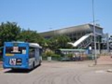
network. A bus interchange sits adjacent the station with services of 501, 520, 523 524, 534 and 543.
Housing
West Ryde has a number of historical buildings including Addison, the second oldest extant building in Australia. The domestic architecture of the suburb largely consists of homes on quarter-acre blocks displaying most of the archetypical Australian styles, including FederationFederation architecture
Federation architecture refers to the architectural style in Australia, which was prevalent from around 1890 to 1920. The period refers to the Federation of Australia on 1 January 1901, when the Australian colonies collectively became the Commonwealth of Australia...
houses, Californian Bungalows, Depression-era houses of weatherboard or fibro
Fibro
Fibro, the shortened form of "Fibrous Cement" - or "Fibrous Asbestos Cement", FAC, is a building material made of compressed fibres cemented into rigid sheets....
with corrugated iron roofs, and 1960s red-brick housing. There is also a substantial number of Askin-era red-brick apartment blocks atop half-acre concrete expanses.
In the past, West Ryde was a working-class suburb which was home to many factories, especially towards Meadowbank
Meadowbank, New South Wales
Meadowbank is a suburb of Sydney, New South Wales, Australia. Meadowbank is located 15 kilometres west of the Sydney central business district, in the local government area of the City of Ryde and part of the Northern Suburbs area...
. The factories of the past are slowly succumbing to demolition, and the construction of waterfront apartments is taking their place, with views of Parramatta River
Parramatta River
The Parramatta River is a waterway in Sydney, New South Wales, Australia. The Parramatta River is the main tributary of Sydney Harbour, a branch of Port Jackson, along with the smaller Lane Cove and Duck Rivers....
and Sydney Olympic Park
Sydney Olympic Park
Sydney Olympic Park is a suburb in western Sydney, in the state of New South Wales, Australia. Sydney Olympic Park is located 16 kilometres west of the Sydney central business district, in the local government area of Auburn Council....
and the suburb is growing more affluent.