
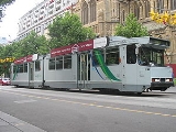
Melbourne tram route 8
Encyclopedia
Tram
route 8 is a public transport
service in Melbourne
, Victoria
, Australia
. It runs from Toorak
to Moreland through the suburbs of Carlton
and South Yarra
. Like most tram routes in Melbourne, it falls within Metcard
ticketing Zone 1.
In response to the State Government's 2001 Melbourne 2030 planning policy
, the Public Transport Users Association
lobbied to extend route 8 to Hartwell.
on route 8. Confusingly, stop 1 is located at the University of Melbourne
, which is in the middle of the route, with stop numbers increasing in both directions.
This route used to be separate routes which was combined from the 22 Moreland to Arts Centre and the route 8 from Toorak to Melbourne University.
Starts in Toorak at the junction of Toorak and Glenferrie Roads (stop 43), and runs via:
Ends at Moreland at the junction of Moreland Road and Cameron St.
Tram
A tram is a passenger rail vehicle which runs on tracks along public urban streets and also sometimes on separate rights of way. It may also run between cities and/or towns , and/or partially grade separated even in the cities...
route 8 is a public transport
Public transport
Public transport is a shared passenger transportation service which is available for use by the general public, as distinct from modes such as taxicab, car pooling or hired buses which are not shared by strangers without private arrangement.Public transport modes include buses, trolleybuses, trams...
service in Melbourne
Melbourne
Melbourne is the capital and most populous city in the state of Victoria, and the second most populous city in Australia. The Melbourne City Centre is the hub of the greater metropolitan area and the Census statistical division—of which "Melbourne" is the common name. As of June 2009, the greater...
, Victoria
Victoria (Australia)
Victoria is the second most populous state in Australia. Geographically the smallest mainland state, Victoria is bordered by New South Wales, South Australia, and Tasmania on Boundary Islet to the north, west and south respectively....
, Australia
Australia
Australia , officially the Commonwealth of Australia, is a country in the Southern Hemisphere comprising the mainland of the Australian continent, the island of Tasmania, and numerous smaller islands in the Indian and Pacific Oceans. It is the world's sixth-largest country by total area...
. It runs from Toorak
Toorak, Victoria
Toorak is a suburb of Melbourne, Victoria, Australia, 5 km south-east from Melbourne's central business district located on a rise on the south side of a bend in the Yarra River. Its Local Government Area is the City of Stonnington...
to Moreland through the suburbs of Carlton
Carlton, Victoria
Carlton is an inner city suburb of Melbourne, Victoria, Australia, 2 km north from Melbourne's central business district. Its Local Government Area is the City of Melbourne...
and South Yarra
South Yarra, Victoria
South Yarra is a suburb in Melbourne, Victoria, Australia, 4 km south-east from Melbourne's central business district. Its Local Government Area are the Cities of Stonnington and Melbourne...
. Like most tram routes in Melbourne, it falls within Metcard
Metcard
"OneLink" redirects here. For the computer/cable company, see OneLink Communications.Metcard is the brand name of an integrated ticketing system used to access public transport in Melbourne, Australia. It is a universal ticket which allows users to ride on the city's Metlink network, consisting of...
ticketing Zone 1.
In response to the State Government's 2001 Melbourne 2030 planning policy
Melbourne 2030
The Metropolitan Strategy Melbourne 2030 is a Victorian Government strategic planning policy framework for the metropolitan area of Greater Melbourne, intended to cover the period 2001-2030. During this period the population of the metropolitan area is expected to grow by a million people to over 5...
, the Public Transport Users Association
Public Transport Users Association
The Public Transport Users Association is a community-based public transport lobby group in Victoria, Australia, based in Melbourne.- History and Aims :...
lobbied to extend route 8 to Hartwell.
Route
There are over 60 stopsTram stop
A tram stop is a place designated for a tram to stop so passengers can board or alight it. Tram stops share most characteristics of bus stops, but because trams operate on rails, they often include railway platforms, especially if stepless entries are provided for accessibility...
on route 8. Confusingly, stop 1 is located at the University of Melbourne
University of Melbourne
The University of Melbourne is a public university located in Melbourne, Victoria. Founded in 1853, it is the second oldest university in Australia and the oldest in Victoria...
, which is in the middle of the route, with stop numbers increasing in both directions.
This route used to be separate routes which was combined from the 22 Moreland to Arts Centre and the route 8 from Toorak to Melbourne University.
Starts in Toorak at the junction of Toorak and Glenferrie Roads (stop 43), and runs via:
- Toorak Road (stop 43 - 27)
- Glenferrie RoadGlenferrie Road, MelbourneGlenferrie Road is a major north–south thoroughfare in Melbourne, Australia.It runs from Kew to Malvern, and includes major shopping districts at both Hawthorn and Malvern.Tram route 16 runs along the entire length of Glenferrie Road...
, tram route 16Melbourne tram route 16Tram route 16 is a public transport service in Melbourne, Victoria, Australia. It runs from the University of Melbourne in the city centre to Kew in the eastern suburbs. It runs through the suburbs of Melbourne, St Kilda, Balaclava, Malvern, and Kew...
(stop 43) - Chapel StreetChapel Street, MelbourneChapel Street is a shopping, dining and entertainment precinct in Melbourne, Australia. It has a myriad shops ranging from exclusive upmarket fashion designers at the South Yarra end to old fashion pawnbrokers towards Windsor.-Geography:...
, tram routes 78Melbourne tram route 78Tram route 78 is a public transport service in Melbourne, Victoria, Australia. The route starts at the Victoria St terminus , then runs along Church St, Richmond, crossing Bridge Rd and Swan St . It continues over the Yarra River along Chapel St, crossing Toorak Rd at stop 49...
and 79Melbourne tram route 79Tram route 79 is a public transport service in Melbourne, Victoria, Australia. It runs from North Richmond to St Kilda Beach through the suburbs of South Yarra, Prahran, Windsor, Balaclava, and St, Kilda. Like most tram routes in Melbourne, it is entirely within Metcard ticketing Zone 1...
(stop 31) - South Yarra Station (stop 30)
- Glenferrie Road
- St. Kilda RoadSt Kilda Road, MelbourneSt Kilda Road is a street in Melbourne, Victoria, Australia. It is part of the locality of Melbourne which has the postcode of 3004 and along with Swanston Street forms a major spine of the city....
(stop 28 - 13)- Domain Interchange, tram route 55Melbourne tram route 55Tram route 55 is a public transport service in Melbourne, Victoria, Australia. It runs from the corner of Bell Street and Melville Road in West Coburg to the Domain Road Interchange - Domain Road and St Kilda Road east of the city....
(stop 20) - Shrine of RemembranceShrine of RemembranceThe Shrine of Remembrance, located in Kings Domain on St Kilda Road, Melbourne, Australia was built as a memorial to the men and women of Victoria who served in World War I and is now a memorial to all Australians who have served in war...
(stop 19) - Southbank Boulevard, tram route 1Melbourne tram route 1Tram route 1 is a public transport service in Melbourne, Victoria, Australia. It runs from the terminus at Nicholson Street and Bell Street in East Coburg to the corner of Victoria Avenue and Beaconsfield Parade in Albert Park....
(stop 16) - National Gallery of VictoriaNational Gallery of VictoriaThe National Gallery of Victoria is an art gallery and museum in Melbourne, Australia. Founded in 1861, it is the oldest and the largest public art gallery in Australia. Since December 2003, NGV has operated across two sites...
, Queen Victoria GardensQueen Victoria Gardens, MelbourneThe Queen Victoria Gardens are Melbourne's memorial to Queen Victoria. Located on 4.8 hectares opposite the Victorian Arts Centre and National Gallery of Victoria, bounded by St Kilda Road, Alexandra Avenue and Linlithgow Avenue....
(stop 15) - Victorian Arts Centre (stop 14)
- Domain Interchange, tram route 55
- Swanston StreetSwanston Street, MelbourneSwanston Street is a major thoroughfare in the centre of Melbourne, Australia. It is historically one of the main streets of central Melbourne, laid out in 1837 as part of the Hoddle Grid, the layout of major streets that makes up the central business district...
(stop 14 - 1)- Flinders StreetFlinders Street, MelbourneFlinders Street is a notable street in Melbourne, Victoria, Australia. Running roughly parallel to the Yarra River, Flinders Street forms the southern edge of the Hoddle Grid. It is exactly one mile in length and one and half chains in width...
, Flinders Street StationFlinders Street StationFlinders Street Station is the central railway station of the suburban railway network of Melbourne, Victoria, Australia. It is on the corner of Flinders and Swanston Streets next to the Yarra River in the heart of the city, stretching from Swanston Street to Queen Street and covering two city...
, Federation SquareFederation SquareFederation Square is a civic centre and cultural precinct in the city of Melbourne, Victoria, Australia....
, St Paul's CathedralSt Paul's Cathedral, MelbourneSt Paul's Cathedral, Melbourne, is the metropolitical and cathedral church of the Anglican Diocese of Melbourne, Victoria in Australia. It is the seat of the Anglican Archbishop of Melbourne and Metropolitan of the Province of Victoria...
, tram routes 70Melbourne tram route 70Tram route 70 is a public transport service in Melbourne, Victoria, Australia. It is operated by Camberwell Depot and runs from the Waterfront City Docklands to Wattle Park in Box Hill South...
, 75Melbourne tram route 75Tram route 75 is a public transport service in Melbourne, Victoria, Australia. It runs from the corner of Spencer Street and La Trobe Street in the city centre to Vermont South in the eastern suburbs....
and the City CircleCity Circle (tram route)The City Circle is a zero-fare tram running around the central business district of Melbourne, Australia. Aimed towards tourists the route passes many Melbourne attractions while running along the CBD's outermost thoroughfares, as well as the developing Docklands waterfront precinct.- History :The...
(stop 13) - Collins StreetCollins Street, MelbourneCollins Street is a major street in the Melbourne central business district and runs approximately east to west.It is notable as Melbourne's traditional main street and best known street, is often regarded as Australia's premier street, with some of the country's finest Victorian era buildings.The...
, Melbourne Town HallMelbourne Town HallMelbourne Town Hall is the central municipal building of the City of Melbourne, Australia, in the State of Victoria. It is located on the northeast corner of Swanston and Collins Streets, in the central business district. It is the seat of the Local Government Area of the City of Melbourne...
, Melbourne City Square, tram routes 11, 12, 42, 48Melbourne tram route 48Tram route 48 is a public transport service in Melbourne, Victoria, Australia. It runs from Victoria Harbour, Docklands to North Balwyn via Collins Street, Spring Street, Wellington Parade and Bridge Road...
, 109Melbourne tram route 109Tram route 109 or simply The 109 is a public transport service in Melbourne, Victoria, Australia. It runs between a terminus in Box Hill and a terminus near Station Pier in Port Melbourne...
and 112Melbourne tram route 112Tram route 112 is a public transport service in Melbourne, Victoria, Australia. It runs from West Preston, in the northern suburbs to St Kilda.Like most tram routes in Melbourne, it falls within Metcard/myki ticketing Zone 1....
(stop 11) - Bourke StreetBourke Street, MelbourneBourke Street is one of Melbourne's best known streets. Historically been regarded as Melbourne's "second street", with the main street being Collins Street and "busier than Bourke Street" is a popular catchphrase. Bourke Street has traditionally been Melbourne's entertainment hub...
, tram routes 86Melbourne tram route 86Tram route 86 is a public transport service in Melbourne, Victoria, Australia. It runs from Bundoora in the northern suburbs to Waterfront City Docklands in the city. It is one of Melbourne's busiest tram routes carrying 44,200 passengers a day...
, 95 and 96Melbourne tram route 96Melbourne tram route 96 is a public transport tram and light rail route in Melbourne, Victoria, Australia.It is one of Melbourne's busiest tram route carrying 39,700 passengers a day with a frequency of every 10 minutes or less during peak...
(stop 10) - Lonsdale StreetLonsdale Street, MelbourneLonsdale Street is located in the centre of Melbourne, Victoria, Australia, part of the Hoddle Grid, it runs roughly east-west. Lonsdale Street's eastern end intersects with Spring Street while its western end intersects with Spencer Street. It is home to multiple office buildings, courts,...
, QV VillageQueen Victoria VillageQueen Victoria Village, generally known as QV Village or just QV, is a precinct in the central business district of Melbourne, Victoria, Australia...
(stop 9) - La Trobe StreetLa Trobe Street, MelbourneLa Trobe Street is a major street in the central business district of Melbourne, Victoria, Australia. It runs roughly from east to west and forms the northern boundary of the CBD ....
, RMIT UniversityRMIT UniversityRMIT University is an Australian public university located in Melbourne, Victoria. It has two branches, referred to as RMIT University in Australia and RMIT International University in Vietnam....
, State Library of VictoriaState Library of VictoriaThe State Library of Victoria is the central library of the state of Victoria, Australia, located in Melbourne. It is on the block bounded by Swanston, La Trobe, Russell, and Little Lonsdale streets, in the northern centre of the central business district...
, Melbourne CentralMelbourne CentralMelbourne Central may refer to:*Melbourne Central Shopping Centre*Melbourne Central railway station...
shopping centre and railway station, tram routes 24Melbourne tram route 24Tram route 24 is a public transport service in Melbourne, Victoria, Australia, which runs from La Trobe Street in the city centre, to North Balwyn. Like most tram routes in Melbourne, it falls within Metcard ticketing Zone 1....
, 30Melbourne tram route 30Tram route 30 is a public transport service in Melbourne, Victoria, Australia. It runs from St Vincents Plaza to Etihad Stadium. It only runs on weekdays, during daylight hours and is one of three fare paying routes to use heritage W class trams....
, 34 and the City CircleCity Circle (tram route)The City Circle is a zero-fare tram running around the central business district of Melbourne, Australia. Aimed towards tourists the route passes many Melbourne attractions while running along the CBD's outermost thoroughfares, as well as the developing Docklands waterfront precinct.- History :The...
(stop 8)
- Flinders Street
- Melbourne University (stops 1, 111 & 2)
- Lygon StLygon Street, MelbourneLygon Street is a street in inner northern Melbourne, Australia running through the suburbs of Carlton, Carlton North, Princes Hill and Brunswick East. Lygon Street's name has become synonymous with Italian restaurants and cafés located in the Carlton part of the street...
(stops 112-127)- Fenwick Street, Melbourne General CemeteryMelbourne General CemeteryThe Melbourne General Cemetery is a large necropolis located north of the city of Melbourne in the suburb of Carlton North.-History:...
(stop 116)
- Fenwick Street, Melbourne General Cemetery
- Moreland Road (stop 129-133)
- Sydney RoadSydney Road, MelbourneSydney Road is a major urban arterial in the northern suburbs of Melbourne, Victoria, Australia.-Geography:...
, tram route 19Melbourne tram route 19Tram route 19 is a public transport service in Melbourne, Victoria, Australia. It runs from Flinders Street in the city centre to North Coburg in the northern suburbs. It runs through the suburbs of Melbourne, Parkville, Brunswick, Coburg, and Coburg North...
(stop 132) - Moreland Station (stop 133)
- Sydney Road
Ends at Moreland at the junction of Moreland Road and Cameron St.