
Flinders Street, Melbourne
Encyclopedia
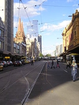
Flinders Street is a notable street in Melbourne
, Victoria
, Australia
. Running roughly parallel to the Yarra River
, Flinders Street forms the southern edge of the Hoddle Grid
. It is exactly one mile (1609.344 m) in length and one and half chains (30.1752 m) in width. It is named for the explorer Matthew Flinders
, who was (erroneously) credited with discovering Port Phillip
at the time of its naming. It extends eastwards as far as Spring Street
and the Treasury Gardens, and westwards past Batman's Hill to the Melbourne Docklands. As the closest street to the river, Flinders Street serviced Melbourne's original river port
. Customs House, now the site for Victoria's Immigration Museum
, is situated on Flinders Street.
as part of the construction of Kings Way. It extended from Downie Street to just east of Custom House Lane. The overpass opened in stages with trams using it from early 1960 and other traffic from mid 1960. Many businesses and properties were overshadowed by the overpass which resulted in property values dropping and the closure of hotels, shops and showrooms. Plans to revitalise the area in the early 1960s never eventuated.
In April 2005, the State Government announced a plan to revitalise the south west corner of the CBD with the overpass destined for demolition. The project commenced in June and concluded in August bringing four and a half decades of depression in the area to an end.
Melbourne
Melbourne is the capital and most populous city in the state of Victoria, and the second most populous city in Australia. The Melbourne City Centre is the hub of the greater metropolitan area and the Census statistical division—of which "Melbourne" is the common name. As of June 2009, the greater...
, Victoria
Victoria (Australia)
Victoria is the second most populous state in Australia. Geographically the smallest mainland state, Victoria is bordered by New South Wales, South Australia, and Tasmania on Boundary Islet to the north, west and south respectively....
, Australia
Australia
Australia , officially the Commonwealth of Australia, is a country in the Southern Hemisphere comprising the mainland of the Australian continent, the island of Tasmania, and numerous smaller islands in the Indian and Pacific Oceans. It is the world's sixth-largest country by total area...
. Running roughly parallel to the Yarra River
Yarra River
The Yarra River, originally Birrarung, is a river in east-central Victoria, Australia. The lower stretches of the river is where the city of Melbourne was established in 1835 and today Greater Melbourne dominates and influences the landscape of its lower reaches...
, Flinders Street forms the southern edge of the Hoddle Grid
Hoddle Grid
The Hoddle Grid is the layout of the streets in the centre of the central business district of Melbourne. Named after its designer, Robert Hoddle, the Grid was laid out in 1837, and later extended...
. It is exactly one mile (1609.344 m) in length and one and half chains (30.1752 m) in width. It is named for the explorer Matthew Flinders
Matthew Flinders
Captain Matthew Flinders RN was one of the most successful navigators and cartographers of his age. In a career that spanned just over twenty years, he sailed with Captain William Bligh, circumnavigated Australia and encouraged the use of that name for the continent, which had previously been...
, who was (erroneously) credited with discovering Port Phillip
Port Phillip
Port Phillip Port Phillip Port Phillip (also commonly referred to as Port Phillip Bay or (locally) just The Bay, is a large bay in southern Victoria, Australia; it is the location of Melbourne. Geographically, the bay covers and the shore stretches roughly . Although it is extremely shallow for...
at the time of its naming. It extends eastwards as far as Spring Street
Spring Street, Melbourne
Spring Street is a major street in the central business district of Melbourne, Victoria, Australia. It runs roughly north-south, and is the easternmost street in the Hoddle Grid. The street travels from Flinders Street in the south, to La Trobe Street and the Carlton Gardens in the north...
and the Treasury Gardens, and westwards past Batman's Hill to the Melbourne Docklands. As the closest street to the river, Flinders Street serviced Melbourne's original river port
Port
A port is a location on a coast or shore containing one or more harbors where ships can dock and transfer people or cargo to or from land....
. Customs House, now the site for Victoria's Immigration Museum
Immigration Museum, Melbourne
The Immigration Museum is a museum primarily displaying Australia's immigration history. It is located on Flinders Street in Melbourne, Victoria, in the Old Customs House...
, is situated on Flinders Street.
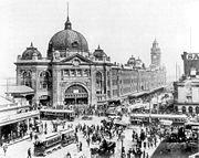
| The street is home to Flinders Street Station Flinders Street Station Flinders Street Station is the central railway station of the suburban railway network of Melbourne, Victoria, Australia. It is on the corner of Flinders and Swanston Streets next to the Yarra River in the heart of the city, stretching from Swanston Street to Queen Street and covering two city... , the central station in Melbourne's suburban rail network. Tram Trams in Melbourne The Melbourne tramway network is a major form of public transport in Melbourne, the capital city of the state of Victoria, Australia. , the network consisted of of track, 487 trams, 28 routes, and 1,773 tram stops. It was therefore the largest urban tramway network in the world, ahead of the... routes 48 Melbourne tram route 48 Tram route 48 is a public transport service in Melbourne, Victoria, Australia. It runs from Victoria Harbour, Docklands to North Balwyn via Collins Street, Spring Street, Wellington Parade and Bridge Road... , 70 Melbourne tram route 70 Tram route 70 is a public transport service in Melbourne, Victoria, Australia. It is operated by Camberwell Depot and runs from the Waterfront City Docklands to Wattle Park in Box Hill South... and 75 Melbourne tram route 75 Tram route 75 is a public transport service in Melbourne, Victoria, Australia. It runs from the corner of Spencer Street and La Trobe Street in the city centre to Vermont South in the eastern suburbs.... , as well as the City Circle route, run along Flinders Street, and the Flinders Street Viaduct Flinders Street Viaduct The Flinders Street Viaduct is a railway bridge in Melbourne, Australia. Made up of six tracks of varying ages, it links Flinders Street Station to Southern Cross Station and forms the main link between the eastern and western parts of the Victorian rail network.The viaduct takes a twisted path,... runs parallel to the street, linking the cities two major railway stations. Other landmarks on Flinders Street include Federation Square Federation Square Federation Square is a civic centre and cultural precinct in the city of Melbourne, Victoria, Australia.... , St Paul's Cathedral St Paul's Cathedral, Melbourne St Paul's Cathedral, Melbourne, is the metropolitical and cathedral church of the Anglican Diocese of Melbourne, Victoria in Australia. It is the seat of the Anglican Archbishop of Melbourne and Metropolitan of the Province of Victoria... , Young & Jackson, the Banana Alley Vaults Banana Alley, Melbourne The Banana Alley Vaults are near the Flinders Street Station in Melbourne, Australia and extend onto the North Bank of the Yarra River.Built in 1891-92, whey were originally known as the Viaduct Buildings, and were built in conjunction with the tracks of the Flinders Street Viaduct that run overhead... , Melbourne Aquarium Melbourne Aquarium Melbourne Aquarium is a Southern Ocean and Antarctic aquarium in central Melbourne, Australia. It is located on the banks of the Yarra River beside and under the Flinders Street Viaduct and the King Street Bridge.-History:... and Batman Park Batman Park Batman Park is an urban park, located on the northern bank of the Yarra River in central Melbourne, Victoria, Australia.Batman Park is a small open grassed space with paths and planted Eucalyptus trees bordered by Spencer Street at the west, Flinders Street Viaduct at the north and King Street to... , which adjoins the Yarra River. It was once home to the Melbourne Fish Market, an ornate building constructed in 1890, covering 23,000 square metres, and of similar design to Flinders Street Station. The market was demolished between 1958 and 1960 after which the site became a public carpark. The site is now home to the three towers of the Northbank Place complex which includes office space, residential apartments, retail outlets and a multi-level carpark. |
 |
King Street Overpass
An overpass was built over the intersection with King StreetKing Street, Melbourne
King Street is a main street in the Melbourne central business district. King Street is part of the Pacific Highway, and used to be part of National Route 1 until the city by-pass road linking the Monash Freeway with the Westgate Freeway was completed...
as part of the construction of Kings Way. It extended from Downie Street to just east of Custom House Lane. The overpass opened in stages with trams using it from early 1960 and other traffic from mid 1960. Many businesses and properties were overshadowed by the overpass which resulted in property values dropping and the closure of hotels, shops and showrooms. Plans to revitalise the area in the early 1960s never eventuated.
In April 2005, the State Government announced a plan to revitalise the south west corner of the CBD with the overpass destined for demolition. The project commenced in June and concluded in August bringing four and a half decades of depression in the area to an end.