

St Kilda Road, Melbourne
Encyclopedia
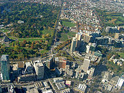
 St Kilda Road is a street in Melbourne
Melbourne
Melbourne is the capital and most populous city in the state of Victoria, and the second most populous city in Australia. The Melbourne City Centre is the hub of the greater metropolitan area and the Census statistical division—of which "Melbourne" is the common name. As of June 2009, the greater...
, Victoria
Victoria (Australia)
Victoria is the second most populous state in Australia. Geographically the smallest mainland state, Victoria is bordered by New South Wales, South Australia, and Tasmania on Boundary Islet to the north, west and south respectively....
, Australia
Australia
Australia , officially the Commonwealth of Australia, is a country in the Southern Hemisphere comprising the mainland of the Australian continent, the island of Tasmania, and numerous smaller islands in the Indian and Pacific Oceans. It is the world's sixth-largest country by total area...
. It is part of the locality of Melbourne which has the postcode of 3004 and along with Swanston Street forms a major spine of the city.
St Kilda Road begins at Princes Bridge (which spans the Yarra River
Yarra River
The Yarra River, originally Birrarung, is a river in east-central Victoria, Australia. The lower stretches of the river is where the city of Melbourne was established in 1835 and today Greater Melbourne dominates and influences the landscape of its lower reaches...
) and connects the Central Business District
Central business district
A central business district is the commercial and often geographic heart of a city. In North America this part of a city is commonly referred to as "downtown" or "city center"...
of Melbourne with the suburb of St Kilda
St Kilda, Victoria
St Kilda is an inner city suburb of Melbourne, Victoria, Australia, 6 km south from Melbourne's central business district. Its Local Government Area is the City of Port Phillip...
ending at Carlisle Street. The road continues as Brighton Road, which becomes the Nepean Highway
Nepean Highway
Nepean Highway runs south from the centre of Melbourne in Victoria, Australia to Portsea, along the eastern shore of Port Phillip. It is the primary road route to central Melbourne from Melbourne's southern suburbs.- History :...
, forming a major arterial connecting the bayside suburbs and Mornington Peninsula
Mornington Peninsula
The Mornington Peninsula is a peninsula located south-east of Melbourne in Victoria, Australia. It is surrounded by Port Phillip to the west, Western Port to the east and Bass Strait to the south, and is connected to the mainland in the north. Geographically, the peninsula begins its protrusion...
to the city.
The east side of the road to High Street, Prahran is in the municipality of the City of Melbourne
City of Melbourne
The City of Melbourne is a Local Government Area in Victoria, Australia, located in the central city area of Melbourne. The city has an area of 36 square kilometres and has an estimated population of 93,105 people. The city's motto is "Vires acquirit eundo" which means "She gathers strength as she...
while the west side of the road and the road south of High Street is in the municipality of the City of Port Phillip
City of Port Phillip
The City of Port Phillip is a Local Government Area in Victoria, Australia. It is located on the northern shores of Port Phillip, south of Melbourne's central business district. It has an area of 20.62 km² and has an estimated population of 96,110 people....
.
History
The first sale of Crown lands in St. Kilda took place on 7 December 1842. Within a few years, St Kilda became a fashionable area for wealthy settlers, with the high ground above the beach offering a cool fresh breeze during Melbourne's hot summer months. St Kilda Road was a dirt track that linked St Kilda to the town centre. The road was impassable by carriage after rains, which turned the road to mud. Prior to the building of the first bridge spanning the Yarra RiverYarra River
The Yarra River, originally Birrarung, is a river in east-central Victoria, Australia. The lower stretches of the river is where the city of Melbourne was established in 1835 and today Greater Melbourne dominates and influences the landscape of its lower reaches...
in 1844, traffic crossed the river by privately operated punts
Cable ferry
A cable ferry is guided and in many cases propelled across a river or other larger body of water by cables connected to both shores. They are also called chain ferries, floating bridges, or punts....
. In 1844, a privately-built wooden trestle
Trestle
A trestle is a rigid frame used as a support, especially referring to a bridge composed of a number of short spans supported by such frames. In the context of trestle bridges, each supporting frame is generally referred to as a bent...
toll bridge was built across the river at Swanston Street.
In 1850, a government-built sandstone free bridge replaced the wooden bridge. In 1854, Kings Domain garden was established. In the same year the government offered four religious groups land on which to build schools. It offered the Wesleyan Methodist Church 10 acres (40,468.6 m²) facing St Kilda Road. It took awhile to find sufficient funds to build the actual school. The foundation stone of Wesley College
Wesley College, Melbourne
Wesley College, Melbourne is an independent, co-educational, Christian day school in Melbourne, Victoria, Australia. Established in 1866, the college is a school of the Uniting Church in Australia. Wesley is the largest school in Australia by enrolment, with 3,511 students and 564 full-time staff...
was laid on 4 January 1865 and the school was official opened on 11 January 1866. In 1855, the government granted 15 acres (60,702.9 m²) on St Kilda Road to the Anglican Church
Anglican Church of Australia
The Anglican Church of Australia is a member church of the Anglican Communion. It was previously officially known as the Church of England in Australia and Tasmania...
on which Melbourne Grammar School
Melbourne Grammar School
Melbourne Grammar School is an independent, Anglican, day and boarding school predominantly for boys, located in South Yarra and Caulfield, suburbs of Melbourne, Victoria, Australia....
was built. The foundation stone was laid on 30 July 1856 and the school was officially opened on 7 April 1858.
During the early 1850s, St Kilda Road was the scene of frequent hold-ups by armed bandits and bushrangers which collectively became known as the St Kilda Road robberies
St Kilda Road robberies
During the first eighteen months of the Victorian gold rush, the section of St Kilda Road between Melbourne and Canvas Town was the scene of frequent hold-ups by armed bandits and bushrangers, mostly former convicts from Van Diemens Land.-The last major offense:On 17 March 1853, gold-buyer Edward...
. Victoria Barracks
Victoria Barracks, Melbourne
Located on St Kilda Road in Melbourne, Australia, Victoria Barracks Melbourne is of architectural and historical significance as one of the most impressive 19th century government buildings in Victoria, Australia.-Pre-World War II:...
were built between 1856 and 1872. In the 1860s, St Kilda was a major bayside resort village. St Kilda Road was a main arterial connecting it with Melbourne, and was planned as a wide European-style boulevard
Boulevard
A Boulevard is type of road, usually a wide, multi-lane arterial thoroughfare, divided with a median down the centre, and roadways along each side designed as slow travel and parking lanes and for bicycle and pedestrian usage, often with an above-average quality of landscaping and scenery...
to accommodate horse-drawn traffic. Fawkner Park
Fawkner Park, Melbourne
Fawkner Park is a popular park in Melbourne's South Yarra and part of the City of Melbourne. It provides recreational areas for teams playing Cricket, Softball, Soccer, Australian Rules Football, Tennis and Rugby.-History and Layout:...
was created in 1862. In 1865 the government made a grant of land on the corner of St. Kilda Road and High Street, Prahran, to the Victorian Deaf and Dumb Institution (now, the Victorian College for the Deaf
Victorian College for the Deaf
The Victorian College for the Deaf , located on St Kilda Road in Melbourne, Australia, is Victoria's oldest deaf school, opening in 1860. It currently provides education in Auslan, the language of the Australian Deaf community, from prep through to year 12...
), which built a blue-stone building which opened in 1866.
The Alfred Hospital
The Alfred Hospital
The Alfred, also known as Alfred Hospital or The Alfred Hospital, is a major hospital in Melbourne, Victoria. It is the second oldest hospital in Victoria, and the oldest Melbourne hospital still operating on its original site...
was established in 1871. From the 1870s, some of Melbourne's wealthiest residents erected grand mansions on significant lots along the street.
In 1877, Cooper and Bailey's Great American International Circus set up on the site of the present Arts Centre
The Arts Centre (Melbourne)
The Victorian Arts Centre is a performing arts centre consisting of a complex of theatres and concert halls in the Melbourne Arts Precinct, located in the inner Melbourne suburb of Southbank in Victoria, Australia....
. The present Princes Bridge
Princes Bridge
Princes Bridge may refer to:* Princes Bridge, in Melbourne over the Yarra River* Princes Bridge railway station, Melbourne* Princes Bridge, over the Barwon River in Victoria...
was built in 1888 to replace the 1850 structure, and cable trams
Melbourne cable tramway system
The Melbourne cable tramway system was a cable car public transportation system operated from 1885 to 1940 in Melbourne, Victoria, Australia....
commenced running from Swanston Street over the bridge along St Kilda Road to Toorak and St Kilda. At this time, the beautiful elm
Elm
Elms are deciduous and semi-deciduous trees comprising the genus Ulmus in the plant family Ulmaceae. The dozens of species are found in temperate and tropical-montane regions of North America and Eurasia, ranging southward into Indonesia. Elms are components of many kinds of natural forests...
trees were planted along the road. The Prince Henry's Hospital (originally called the Melbourne Homoeopathic Hospital) was opened in St Kilda Road in 1885, and existed until 1991.
Until the end of the 19th century, the Yarra River was subject to regular flooding. A new channel for the Yarra River was dug from 1896 to 1900 to straighten and widen the river. The spoil was used to fill the swampy lagoons and brickmakers pits and raise the height of the river bank where Alexandra Gardens
Alexandra Gardens, Melbourne
The Alexandra Gardens are located on the south bank of the Yarra River, opposite Federation Square and the Melbourne Central Business District, in Victoria, Australia. The Gardens are bounded by the Yarra River to the north, Princes and Swan street bridges, with Queen Victoria Gardens and Kings...
now stands. The Gardens were opened in 1901.
In 1901 the Arts Centre site became home to a permanent circus, Olympia, built by the Fitzgerald Brothers' Circus. In 1904, the area of the site not occupied by Fitzgerald's was developed as a fashionable meeting place called Prince's Court. This area featured a Japanese Tea House, open-air theatre, miniature train, water chute and a 15-member military band. In 1907, Wirth Brother's Circus took over the entire site from Fitzgerald's and remained there for the next 50 years. By 1911 they had built a new circus Hippodrome and a roller skating rink, and had leased the original Olympia as a cinema. During World War I
World War I
World War I , which was predominantly called the World War or the Great War from its occurrence until 1939, and the First World War or World War I thereafter, was a major war centred in Europe that began on 28 July 1914 and lasted until 11 November 1918...
some of the buildings were used as nursing homes for soldiers and nurses. During the 1920s a new Green Mill Dance Hall replaced the Jazz Pavilion and Olympia Dancing Palace.
The Melbourne Hebrew Congregation
Melbourne Hebrew Congregation
The Melbourne Hebrew Congregation , or Toorak Shule, is the oldest Jewish congregation in Melbourne, Australia. Formed in 1841, the congregation was originally located on Bourke Street before moving to Toorak Road, South Yarra in 1930.-History:The first Jews in Melbourne arrived around the time of...
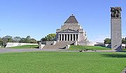
opened a 1300-seat synagogue on the corner of Toorak Road in 1930. During the depression of the 1930s, many of the mansions on St Kilda Road were subdivided into units with extensions to the rear of the buildings, resulting in only a few of them remaining today. The Shrine of Remembrance
Shrine of Remembrance
The Shrine of Remembrance, located in Kings Domain on St Kilda Road, Melbourne, Australia was built as a memorial to the men and women of Victoria who served in World War I and is now a memorial to all Australians who have served in war...
was completed in September 1934.
In the 1950s, an effort was made to introduce higher-density residential living to the area. Housing Commission of Victoria flats, like the Stanhill Flats were erected along nearby Queens Road. In the 1960s, local planning agencies changed the zoning from residential to commercial, in an effort to create more office space for a growing local financial industry
Financial services
Financial services refer to services provided by the finance industry. The finance industry encompasses a broad range of organizations that deal with the management of money. Among these organizations are credit unions, banks, credit card companies, insurance companies, consumer finance companies,...
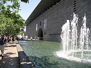
. The area was given the postcode 3004, and was allowed to use the title "Melbourne", effectively extending the central business district area. The Green Mill Dance Hall closed in 1950 and the remainder of the Wirth buildings on the Arts Centre site were destroyed by fire in 1953. Much of site was used as an outdoor carpark before construction of the National Gallery of Victoria
National Gallery of Victoria
The National Gallery of Victoria is an art gallery and museum in Melbourne, Australia. Founded in 1861, it is the oldest and the largest public art gallery in Australia. Since December 2003, NGV has operated across two sites...
commenced in the early 1960s. The gallery opened in 1968.
In the 1970s, the Victorian government compulsorily acquired much of the land around St Kilda Junction
St Kilda Junction
St Kilda Junction is one of the most notorious intersections in Melbourne, Australia. It is located in the suburb of St Kilda, and bordering Windsor, Melbourne and St Kilda East, and is the meeting point of the major roads Punt Road, St Kilda Road, Dandenong Road/Queens Way/Princes Highway and...
and demolished many of the buildings including the landmark Junction Hotel as part of a street-widening program to accommodate more vehicular traffic. What was once High Street was adjusted to the approximate width of St Kilda Road and renamed to become part of St Kilda Road, effectively extending it to Carlisle Street. An underpass was created under the road to connect Queens Road to Dandenong Road.
Construction of the Arts Centre began in 1973 following some delays. The complex opened in stages, with Hamer Hall opening in 1982, and the Theatres Building opening in 1984. The redevelopment of the Southbank
Southbank, Victoria
Southbank is an inner city suburb of Melbourne, Victoria, Australia located direct south of the Yarra River opposite Melbourne's Hoddle Grid. The northernmost area is considered part of the Central Business District and Central Activities District of the city. Its Local Government Area are the...
precinct along the Yarra River commenced in 1990 with the construction of the Southbank Promenade.
Since the 1980s, heritage controls have protected the few surviving mansions and height limits have been introduced to bring uniformity to the street.
Today
The street is known for its width and leafiness.
For most of its length, the wide street consists of a wide shared footpath (lined with Elm
Elm
Elms are deciduous and semi-deciduous trees comprising the genus Ulmus in the plant family Ulmaceae. The dozens of species are found in temperate and tropical-montane regions of North America and Eurasia, ranging southward into Indonesia. Elms are components of many kinds of natural forests...
trees), street side parking, a bicycle lane, two lanes for motor vehicle traffic, median strip reserve (lined with mature London Plane
London Plane
Platanus × acerifolia, the London plane, London planetree, or hybrid plane, is a tree in the genus Platanus. It is usually thought to be a hybrid of Platanus orientalis and the Platanus occidentalis . Some authorities think that it may be a cultivar of P...
trees), another two lanes for motor vehicle traffic and a tram line on either side.
Melbourne's trams
Trams in Melbourne
The Melbourne tramway network is a major form of public transport in Melbourne, the capital city of the state of Victoria, Australia. , the network consisted of of track, 487 trams, 28 routes, and 1,773 tram stops. It was therefore the largest urban tramway network in the world, ahead of the...
travel down the centre of the road along the length of the street.
There have been proposals for a separated bike lane to be installed.
Landmarks
- Alexandra GardensAlexandra Gardens, MelbourneThe Alexandra Gardens are located on the south bank of the Yarra River, opposite Federation Square and the Melbourne Central Business District, in Victoria, Australia. The Gardens are bounded by the Yarra River to the north, Princes and Swan street bridges, with Queen Victoria Gardens and Kings...
- Victorian Arts Centre
- National Gallery of VictoriaNational Gallery of VictoriaThe National Gallery of Victoria is an art gallery and museum in Melbourne, Australia. Founded in 1861, it is the oldest and the largest public art gallery in Australia. Since December 2003, NGV has operated across two sites...
- Victorian College of the ArtsVictorian College of the ArtsThe Faculty of the VCA and Music is a faculty of the University of Melbourne, in Victoria . VCAM is located near the Melbourne central business district, on two campuses, one - the Melbourne Conservatorium of Music - on the Parkville campus of the University of Melbourne, and the other - the...
- Victoria BarracksVictoria Barracks, MelbourneLocated on St Kilda Road in Melbourne, Australia, Victoria Barracks Melbourne is of architectural and historical significance as one of the most impressive 19th century government buildings in Victoria, Australia.-Pre-World War II:...
- Shrine of RemembranceShrine of RemembranceThe Shrine of Remembrance, located in Kings Domain on St Kilda Road, Melbourne, Australia was built as a memorial to the men and women of Victoria who served in World War I and is now a memorial to all Australians who have served in war...
- Domain Interchange
- Melbourne Grammar SchoolMelbourne Grammar SchoolMelbourne Grammar School is an independent, Anglican, day and boarding school predominantly for boys, located in South Yarra and Caulfield, suburbs of Melbourne, Victoria, Australia....
- Former Chevron Hotel - now an apartment complex.
- Victorian College for the DeafVictorian College for the DeafThe Victorian College for the Deaf , located on St Kilda Road in Melbourne, Australia, is Victoria's oldest deaf school, opening in 1860. It currently provides education in Auslan, the language of the Australian Deaf community, from prep through to year 12...
and Deaf Children AustraliaDeaf Children AustraliaDeaf Children Australia is a charity that supports young deaf and hard of hearing people in Australia.Formerly known as Victorian Services for Deaf Children, Deaf Children Australia was founded in the Victorian capital of Melbourne in 1860. The offices are in an excellent Gothic Revival building...
's historic bluestoneBluestoneBluestone is a cultural or commercial name for a number of dimension or building stone varieties, including:*a feldspathic sandstone in the U.S. and Canada;*limestone in the Shenandoah Valley in the U.S...
building - Victorian Institute for the Blind
- Wesley CollegeWesley College, MelbourneWesley College, Melbourne is an independent, co-educational, Christian day school in Melbourne, Victoria, Australia. Established in 1866, the college is a school of the Uniting Church in Australia. Wesley is the largest school in Australia by enrolment, with 3,511 students and 564 full-time staff...
- St. Kilda Road Campuses - St Kilda JunctionSt Kilda JunctionSt Kilda Junction is one of the most notorious intersections in Melbourne, Australia. It is located in the suburb of St Kilda, and bordering Windsor, Melbourne and St Kilda East, and is the meeting point of the major roads Punt Road, St Kilda Road, Dandenong Road/Queens Way/Princes Highway and...
Events
- Southbank Sunday markets - held outside the Arts Centre.
- 2006 Commonwealth Games Opening Ceremony2006 Commonwealth Games Opening CeremonyThe Opening Ceremony of the 2006 Commonwealth Games was held on 15 March 2006 at Melbourne Cricket Ground in Melbourne, Victoria, Australia. The ceremony was conceived and produced by Jack Morton Worldwide, which also produced the ceremonies for the Manchester 2002 Commonwealth...
- Great Melbourne Bike Ride
Because of its width and central location, the road is used for many marches, including the following regular events:
- MoombaMoombaMoomba is Australia's largest free community festival and one of the longest running festivals in Australia. Held annually in the city of Melbourne, Australia, Moomba is celebrated during the Labour Day long weekend , and has been celebrated since 1955...
- ANZAC DayANZAC DayAnzac Day is a national day of remembrance in Australia and New Zealand, commemorated by both countries on 25 April every year to honour the members of the Australian and New Zealand Army Corps who fought at Gallipoli in the Ottoman Empire during World War I. It now more broadly commemorates all...
parade - to the Shrine - Starting point for the 2006 AFL Grand Final Parade2006 AFL Grand FinalThe 2006 AFL Grand Final was an Australian rules football game contested between the Sydney Swans and West Coast Eagles, held at the Melbourne Cricket Ground in Melbourne on 30 September 2006. It was the 110th annual Grand Final of the Victorian Football League/Australian Football League, staged to...