
Melbourne tram route 79
Encyclopedia
Tram
route 79 is a public transport
service in Melbourne
, Victoria
, Australia
. It runs from North Richmond to St Kilda
Beach through the suburbs of South Yarra
, Prahran
, Windsor
, Balaclava
, and St, Kilda. Like most tram routes in Melbourne, it is entirely within Metcard
ticketing Zone 1. It is one of the few Melbourne tram lines that does not pass through the CBD.
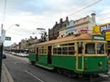
This route is run from the Glenhuntly Tram Depot
mainly by W class trams, with the occasional Z class. The service runs during weekday evenings, Saturday afternoons and evenings, and all day Sunday.
.
Starts at Victoria St
Terminus, North Richmond, then runs via:
Tram
A tram is a passenger rail vehicle which runs on tracks along public urban streets and also sometimes on separate rights of way. It may also run between cities and/or towns , and/or partially grade separated even in the cities...
route 79 is a public transport
Public transport
Public transport is a shared passenger transportation service which is available for use by the general public, as distinct from modes such as taxicab, car pooling or hired buses which are not shared by strangers without private arrangement.Public transport modes include buses, trolleybuses, trams...
service in Melbourne
Melbourne
Melbourne is the capital and most populous city in the state of Victoria, and the second most populous city in Australia. The Melbourne City Centre is the hub of the greater metropolitan area and the Census statistical division—of which "Melbourne" is the common name. As of June 2009, the greater...
, Victoria
Victoria (Australia)
Victoria is the second most populous state in Australia. Geographically the smallest mainland state, Victoria is bordered by New South Wales, South Australia, and Tasmania on Boundary Islet to the north, west and south respectively....
, Australia
Australia
Australia , officially the Commonwealth of Australia, is a country in the Southern Hemisphere comprising the mainland of the Australian continent, the island of Tasmania, and numerous smaller islands in the Indian and Pacific Oceans. It is the world's sixth-largest country by total area...
. It runs from North Richmond to St Kilda
St Kilda, Victoria
St Kilda is an inner city suburb of Melbourne, Victoria, Australia, 6 km south from Melbourne's central business district. Its Local Government Area is the City of Port Phillip...
Beach through the suburbs of South Yarra
South Yarra, Victoria
South Yarra is a suburb in Melbourne, Victoria, Australia, 4 km south-east from Melbourne's central business district. Its Local Government Area are the Cities of Stonnington and Melbourne...
, Prahran
Prahran, Victoria
Prahran , also known colloquially as "Pran", is a suburb in Melbourne, Victoria, Australia, 5 km south-east from Melbourne's central business district. Its Local Government Area is the City of Stonnington. At the 2006 Census, Prahran had a population of 10,651. It is a part of Melbourne with...
, Windsor
Windsor, Victoria
Windsor is a suburb in Melbourne, Victoria, Australia, 5 km south-east from Melbourne's central business district. Its Local Government Area is the City of Stonnington. At the 2006 Census, Windsor had a population of 6394....
, Balaclava
Balaclava, Victoria
Balaclava is a suburb of Melbourne, Victoria, in Australia. It is situated in the south-east of the city in the St Kilda East area and is bounded by Inkerman Street to the north, Chapel Street to the west, Hotham Street to the east and Oak Grove and Los Angeles Court to the south. In terms of its...
, and St, Kilda. Like most tram routes in Melbourne, it is entirely within Metcard
Metcard
"OneLink" redirects here. For the computer/cable company, see OneLink Communications.Metcard is the brand name of an integrated ticketing system used to access public transport in Melbourne, Australia. It is a universal ticket which allows users to ride on the city's Metlink network, consisting of...
ticketing Zone 1. It is one of the few Melbourne tram lines that does not pass through the CBD.
This route is run from the Glenhuntly Tram Depot
Glenhuntly Tram Depot
Glenhuntly Tram Depot is located in South Caulfield, a suburb of Melbourne in Victoria, Australia.It is one of 8 depots operated in the Yarra Trams network. The depot was opened in 1923.- Yard layout :...
mainly by W class trams, with the occasional Z class. The service runs during weekday evenings, Saturday afternoons and evenings, and all day Sunday.
Route
There are 32 stops on route 79, which are numbered in decreasing order from RichmondRichmond, Victoria
Richmond is a suburb in Melbourne, Victoria, Australia, 3 km south-east from Melbourne's central business district. Its Local Government Area is the City of Yarra...
.
Starts at Victoria St
Victoria Street, Melbourne
Victoria Street is one of the major thoroughfares of inner Melbourne. Running east to west, Victoria Street touches the Hoddle Grid at the intersection of La Trobe Street and Spring Street, opposite the Carlton Gardens. It runs from its terminus at the intersection of Munster Terrace in North...
Terminus, North Richmond, then runs via:
- Church Street (stops 65-53)
- Victoria Street, tram routes 24Melbourne tram route 24Tram route 24 is a public transport service in Melbourne, Victoria, Australia, which runs from La Trobe Street in the city centre, to North Balwyn. Like most tram routes in Melbourne, it falls within Metcard ticketing Zone 1....
and 109Melbourne tram route 109Tram route 109 or simply The 109 is a public transport service in Melbourne, Victoria, Australia. It runs between a terminus in Box Hill and a terminus near Station Pier in Port Melbourne...
(stop 65) - Bridge RoadBridge Road, MelbourneBridge Road is a major shopping strip in Melbourne, Australia. It is best known for its abundance of clothing factory outlets, which makes it a popular tourist attraction...
, tram routes 48Melbourne tram route 48Tram route 48 is a public transport service in Melbourne, Victoria, Australia. It runs from Victoria Harbour, Docklands to North Balwyn via Collins Street, Spring Street, Wellington Parade and Bridge Road...
and 75Melbourne tram route 75Tram route 75 is a public transport service in Melbourne, Victoria, Australia. It runs from the corner of Spencer Street and La Trobe Street in the city centre to Vermont South in the eastern suburbs....
(stop 61) - Swan StreetSwan Street, MelbourneSwan Street is a major street running through the Melbourne suburbs of Richmond, Cremorne and Burnley. The section of the street between Punt Road and Alexandra Avenue is now known as Olympic Boulevard....
, tram route 70Melbourne tram route 70Tram route 70 is a public transport service in Melbourne, Victoria, Australia. It is operated by Camberwell Depot and runs from the Waterfront City Docklands to Wattle Park in Box Hill South...
(stop 57) - East Richmond StationEast Richmond railway station, MelbourneEast Richmond is a railway station in Melbourne, Victoria, Australia. It is located on the Lilydale, Belgrave, Glen Waverley, and Alamein railway lines, on Church Street, in the suburb of Cremorne...
(stop 56)
- Victoria Street, tram routes 24
- Chapel Street (stop 52-37)
- Toorak Road, tram route 8Melbourne tram route 8Tram route 8 is a public transport service in Melbourne, Victoria, Australia. It runs from Toorak to Moreland through the suburbs of Carlton and South Yarra...
(stop 50) - Jam FactoryThe Jam Factoryright|thumb|250px|Jam Factory, Chapel StreetThe Jam Factory is a shopping and entertainment centre, located in cosmopolitan Chapel Street, South Yarra, a suburb of Melbourne, Australia. The centre contains a Village Cinema complex, Intencity arcade, fashion stores and numerous cafés and...
(stop 48) - Commercial Road, Prahran MarketPrahran MarketThe Prahran Market is one of the premier fresh food markets in Melbourne, Australia. It has existed on its present site in Commercial Road, South Yarra, some 200 metres from Chapel Street, for over 125 years. The market offers a variety of stalls and shops offering fresh fruit and vegetables, meat,...
tram route 72Melbourne tram route 72Tram route 72 is a public transport service in Melbourne, Victoria, Australia. It runs from the University of Melbourne in the city centre to Camberwell in the eastern suburbs. It runs through the suburbs of Melbourne, South Yarra, Toorak, Malvern, Glen Iris, and Camberwell...
(stop 47) - Prahran Town HallPrahran Town HallPrahran Town Hall is a civic building located on the corner of Chapel Street and Greville Street in Prahran, a suburb of Melbourne, Australia....
(stop 46) - High Street, Swinburne University, tram route 6Melbourne tram route 6Tram route 6 is a public transport service in Melbourne, Victoria, Australia. It runs from the University of Melbourne in the city centre to Glen Iris in the eastern suburbs....
(stop 45) - Windsor StationWindsor railway station, MelbourneWindsor is a railway station in Melbourne, Victoria, Australia. It serves the Sandringham railway line and is located in the suburb of Windsor. The station is near the intersection of Chapel Street and Dandenong Road, and is listed on the Victorian Heritage Register.-Platforms and services:Platform...
(stop 43) - Dandenong Road, Astor TheatreThe Astor TheatreThe Astor Theatre is a classic, single-screen cinema located in the inner Melbourne suburb of St Kilda, that has a long and illustrious history....
, tram routes 5Melbourne tram route 5Tram route 5 is a public transport service in Melbourne, Victoria, Australia. It runs from the University of Melbourne north of the city centre to Malvern East in the eastern suburbs. The destination is, however, displayed as Malvern, although the route technically ends within Malvern East...
and 64Melbourne tram route 64Tram route 64 is a public transport service in Melbourne, Victoria, Australia. It runs from the University of Melbourne in the city centre to East Brighton in the southern suburbs. It runs through the suburbs of Melbourne, Windsor, Caulfield, and Brighton East...
(stop 42) - tram routes 3Melbourne tram route 3Tram route 3 is a public transport service in Melbourne, Victoria, Australia. It runs from the University of Melbourne north of the city centre to Malvern East in the eastern suburbs....
and 16Melbourne tram route 16Tram route 16 is a public transport service in Melbourne, Victoria, Australia. It runs from the University of Melbourne in the city centre to Kew in the eastern suburbs. It runs through the suburbs of Melbourne, St Kilda, Balaclava, Malvern, and Kew...
(stop 37)
- Toorak Road, tram route 8
- Carlisle Street (stop 36-32)
- St Kilda Town HallSt Kilda Town HallSt Kilda Town Hall is a city hall in St Kilda, Victoria, Australia.-Architecture:The design by local architect William Pitt in the Classical Revival style. It was built in 1890. Pitt's grand vision for the town hall was never completed...
and library (stop 36) - St Kilda RoadSt Kilda Road, MelbourneSt Kilda Road is a street in Melbourne, Victoria, Australia. It is part of the locality of Melbourne which has the postcode of 3004 and along with Swanston Street forms a major spine of the city....
, tram route 67Melbourne tram route 67The Melbourne Tram Route 67 is an Australian tram route which runs back and forth from Carnegie to the University of Melbourne.The route starts at the Carnegie terminus, located in Trugininni Road at the corner of Koornang Road, and travels via Glen Huntly Road, Brighton Road, St Kilda Road and...
(stop 35) - Acland StreetAcland Street, MelbourneAcland Street is a street in the Melbourne suburb of St Kilda, which enjoys great popularity as a recreational area, mainly due to its many restaurants and its proximity to the entertainment areas along St Kilda beach...
, Luna ParkLuna Park, MelbourneFor other amusement parks of the same name, see Luna Park; for other uses of the phrase, see Luna Park Melbourne's Luna Park is a historic amusement park located on the foreshore of Port Phillip Bay in St Kilda, Victoria, an inner suburb of Melbourne, Australia...
, tram route 96Melbourne tram route 96Melbourne tram route 96 is a public transport tram and light rail route in Melbourne, Victoria, Australia.It is one of Melbourne's busiest tram route carrying 39,700 passengers a day with a frequency of every 10 minutes or less during peak...
(stop 31)
- St Kilda Town Hall