
Melbourne tram route 16
Encyclopedia
Tram
route 16 is a public transport
service in Melbourne
, Victoria
, Australia
. It runs from the University of Melbourne
in the city centre to Kew
in the eastern suburb
s. It runs through the suburbs of Melbourne, St Kilda
, Balaclava
, Malvern
, and Kew. Like most tram routes in Melbourne, it is entirely within Metcard
ticketing Zone 1.
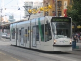
The route is operated by a mix of Z1, Z3, D1
and D2 class trams.
In response to the State Government's 2001 Melbourne 2030 planning policy
, the Public Transport Users Association
lobbied to extend route 16 to to Kew Junction
.
Starts at University of Melbourne terminus (stop 1), Swanston
and Faraday Streets; then runs via:
Terminates at the intersection of Glenferrie Road and Cotham Road, Kew (stop 80).
This route is the amalgamation of the old route 69 from Kew to St Kilda Beach and the 16 from Melbourne University to St Kilda Beach. As both of those old routes used to through-route during the peak hours, it was decided that the routes be merged with the number 16 be kept.
Tram
A tram is a passenger rail vehicle which runs on tracks along public urban streets and also sometimes on separate rights of way. It may also run between cities and/or towns , and/or partially grade separated even in the cities...
route 16 is a public transport
Public transport
Public transport is a shared passenger transportation service which is available for use by the general public, as distinct from modes such as taxicab, car pooling or hired buses which are not shared by strangers without private arrangement.Public transport modes include buses, trolleybuses, trams...
service in Melbourne
Melbourne
Melbourne is the capital and most populous city in the state of Victoria, and the second most populous city in Australia. The Melbourne City Centre is the hub of the greater metropolitan area and the Census statistical division—of which "Melbourne" is the common name. As of June 2009, the greater...
, Victoria
Victoria (Australia)
Victoria is the second most populous state in Australia. Geographically the smallest mainland state, Victoria is bordered by New South Wales, South Australia, and Tasmania on Boundary Islet to the north, west and south respectively....
, Australia
Australia
Australia , officially the Commonwealth of Australia, is a country in the Southern Hemisphere comprising the mainland of the Australian continent, the island of Tasmania, and numerous smaller islands in the Indian and Pacific Oceans. It is the world's sixth-largest country by total area...
. It runs from the University of Melbourne
University of Melbourne
The University of Melbourne is a public university located in Melbourne, Victoria. Founded in 1853, it is the second oldest university in Australia and the oldest in Victoria...
in the city centre to Kew
Kew, Victoria
Kew is a suburb in Melbourne, Victoria, Australia, 6 km east from Melbourne's central business district. Its Local Government Area is the City of Boroondara. At the 2006 Census, Kew had a population of 22,516....
in the eastern suburb
Suburb
The word suburb mostly refers to a residential area, either existing as part of a city or as a separate residential community within commuting distance of a city . Some suburbs have a degree of administrative autonomy, and most have lower population density than inner city neighborhoods...
s. It runs through the suburbs of Melbourne, St Kilda
St Kilda, Victoria
St Kilda is an inner city suburb of Melbourne, Victoria, Australia, 6 km south from Melbourne's central business district. Its Local Government Area is the City of Port Phillip...
, Balaclava
Balaclava, Victoria
Balaclava is a suburb of Melbourne, Victoria, in Australia. It is situated in the south-east of the city in the St Kilda East area and is bounded by Inkerman Street to the north, Chapel Street to the west, Hotham Street to the east and Oak Grove and Los Angeles Court to the south. In terms of its...
, Malvern
Malvern, Victoria
Malvern is a suburb in Melbourne, Victoria, Australia, 8 km south-east from Melbourne's central business district. Its Local Government Area is the City of Stonnington. At the 2006 Census, Malvern had a population of 9,422.-History:...
, and Kew. Like most tram routes in Melbourne, it is entirely within Metcard
Metcard
"OneLink" redirects here. For the computer/cable company, see OneLink Communications.Metcard is the brand name of an integrated ticketing system used to access public transport in Melbourne, Australia. It is a universal ticket which allows users to ride on the city's Metlink network, consisting of...
ticketing Zone 1.
The route is operated by a mix of Z1, Z3, D1
D1 class Melbourne tram
The D class, or Combino is a type of electric tram operating in Melbourne, Victoria, Australia. It was built by Siemens in Düsseldorf, Germany, and the first unit was delivered to the city in 2002...
and D2 class trams.
In response to the State Government's 2001 Melbourne 2030 planning policy
Melbourne 2030
The Metropolitan Strategy Melbourne 2030 is a Victorian Government strategic planning policy framework for the metropolitan area of Greater Melbourne, intended to cover the period 2001-2030. During this period the population of the metropolitan area is expected to grow by a million people to over 5...
, the Public Transport Users Association
Public Transport Users Association
The Public Transport Users Association is a community-based public transport lobby group in Victoria, Australia, based in Melbourne.- History and Aims :...
lobbied to extend route 16 to to Kew Junction
Kew, Victoria
Kew is a suburb in Melbourne, Victoria, Australia, 6 km east from Melbourne's central business district. Its Local Government Area is the City of Boroondara. At the 2006 Census, Kew had a population of 22,516....
.
Route
There are 80 stops on route 16.Starts at University of Melbourne terminus (stop 1), Swanston
Swanston Street, Melbourne
Swanston Street is a major thoroughfare in the centre of Melbourne, Australia. It is historically one of the main streets of central Melbourne, laid out in 1837 as part of the Hoddle Grid, the layout of major streets that makes up the central business district...
and Faraday Streets; then runs via:
- Swanston Street (stops 1 - 13)
- RMIT UniversityRMIT UniversityRMIT University is an Australian public university located in Melbourne, Victoria. It has two branches, referred to as RMIT University in Australia and RMIT International University in Vietnam....
(stop 7) - La Trobe StreetLa Trobe Street, MelbourneLa Trobe Street is a major street in the central business district of Melbourne, Victoria, Australia. It runs roughly from east to west and forms the northern boundary of the CBD ....
, State Library of VictoriaState Library of VictoriaThe State Library of Victoria is the central library of the state of Victoria, Australia, located in Melbourne. It is on the block bounded by Swanston, La Trobe, Russell, and Little Lonsdale streets, in the northern centre of the central business district...
, Melbourne CentralMelbourne CentralMelbourne Central may refer to:*Melbourne Central Shopping Centre*Melbourne Central railway station...
shopping centre and railway station, tram routes 24Melbourne tram route 24Tram route 24 is a public transport service in Melbourne, Victoria, Australia, which runs from La Trobe Street in the city centre, to North Balwyn. Like most tram routes in Melbourne, it falls within Metcard ticketing Zone 1....
, 30Melbourne tram route 30Tram route 30 is a public transport service in Melbourne, Victoria, Australia. It runs from St Vincents Plaza to Etihad Stadium. It only runs on weekdays, during daylight hours and is one of three fare paying routes to use heritage W class trams....
, 34 and the City CircleCity Circle (tram route)The City Circle is a zero-fare tram running around the central business district of Melbourne, Australia. Aimed towards tourists the route passes many Melbourne attractions while running along the CBD's outermost thoroughfares, as well as the developing Docklands waterfront precinct.- History :The...
(stop 8) - Lonsdale StreetLonsdale Street, MelbourneLonsdale Street is located in the centre of Melbourne, Victoria, Australia, part of the Hoddle Grid, it runs roughly east-west. Lonsdale Street's eastern end intersects with Spring Street while its western end intersects with Spencer Street. It is home to multiple office buildings, courts,...
, QV VillageQueen Victoria VillageQueen Victoria Village, generally known as QV Village or just QV, is a precinct in the central business district of Melbourne, Victoria, Australia...
(stop 9) - Bourke StreetBourke Street, MelbourneBourke Street is one of Melbourne's best known streets. Historically been regarded as Melbourne's "second street", with the main street being Collins Street and "busier than Bourke Street" is a popular catchphrase. Bourke Street has traditionally been Melbourne's entertainment hub...
, tram routes 86Melbourne tram route 86Tram route 86 is a public transport service in Melbourne, Victoria, Australia. It runs from Bundoora in the northern suburbs to Waterfront City Docklands in the city. It is one of Melbourne's busiest tram routes carrying 44,200 passengers a day...
, 95 and 96Melbourne tram route 96Melbourne tram route 96 is a public transport tram and light rail route in Melbourne, Victoria, Australia.It is one of Melbourne's busiest tram route carrying 39,700 passengers a day with a frequency of every 10 minutes or less during peak...
(stop 10) - Collins StreetCollins Street, MelbourneCollins Street is a major street in the Melbourne central business district and runs approximately east to west.It is notable as Melbourne's traditional main street and best known street, is often regarded as Australia's premier street, with some of the country's finest Victorian era buildings.The...
, Melbourne Town HallMelbourne Town HallMelbourne Town Hall is the central municipal building of the City of Melbourne, Australia, in the State of Victoria. It is located on the northeast corner of Swanston and Collins Streets, in the central business district. It is the seat of the Local Government Area of the City of Melbourne...
, Melbourne City Square, tram routes 11, 12, 42, 48Melbourne tram route 48Tram route 48 is a public transport service in Melbourne, Victoria, Australia. It runs from Victoria Harbour, Docklands to North Balwyn via Collins Street, Spring Street, Wellington Parade and Bridge Road...
, 109Melbourne tram route 109Tram route 109 or simply The 109 is a public transport service in Melbourne, Victoria, Australia. It runs between a terminus in Box Hill and a terminus near Station Pier in Port Melbourne...
and 112Melbourne tram route 112Tram route 112 is a public transport service in Melbourne, Victoria, Australia. It runs from West Preston, in the northern suburbs to St Kilda.Like most tram routes in Melbourne, it falls within Metcard/myki ticketing Zone 1....
(stop 11) - Flinders StreetFlinders Street, MelbourneFlinders Street is a notable street in Melbourne, Victoria, Australia. Running roughly parallel to the Yarra River, Flinders Street forms the southern edge of the Hoddle Grid. It is exactly one mile in length and one and half chains in width...
, Flinders Street StationFlinders Street StationFlinders Street Station is the central railway station of the suburban railway network of Melbourne, Victoria, Australia. It is on the corner of Flinders and Swanston Streets next to the Yarra River in the heart of the city, stretching from Swanston Street to Queen Street and covering two city...
, Federation SquareFederation SquareFederation Square is a civic centre and cultural precinct in the city of Melbourne, Victoria, Australia....
, St Paul's CathedralSt Paul's Cathedral, MelbourneSt Paul's Cathedral, Melbourne, is the metropolitical and cathedral church of the Anglican Diocese of Melbourne, Victoria in Australia. It is the seat of the Anglican Archbishop of Melbourne and Metropolitan of the Province of Victoria...
, tram routes 70Melbourne tram route 70Tram route 70 is a public transport service in Melbourne, Victoria, Australia. It is operated by Camberwell Depot and runs from the Waterfront City Docklands to Wattle Park in Box Hill South...
and 75Melbourne tram route 75Tram route 75 is a public transport service in Melbourne, Victoria, Australia. It runs from the corner of Spencer Street and La Trobe Street in the city centre to Vermont South in the eastern suburbs....
and the City CircleCity Circle (tram route)The City Circle is a zero-fare tram running around the central business district of Melbourne, Australia. Aimed towards tourists the route passes many Melbourne attractions while running along the CBD's outermost thoroughfares, as well as the developing Docklands waterfront precinct.- History :The...
(stop 13)
- RMIT University
- St Kilda RoadSt Kilda Road, MelbourneSt Kilda Road is a street in Melbourne, Victoria, Australia. It is part of the locality of Melbourne which has the postcode of 3004 and along with Swanston Street forms a major spine of the city....
(stops 14 - 30)- Victorian Arts Centre (stop 14)
- National Gallery of VictoriaNational Gallery of VictoriaThe National Gallery of Victoria is an art gallery and museum in Melbourne, Australia. Founded in 1861, it is the oldest and the largest public art gallery in Australia. Since December 2003, NGV has operated across two sites...
, Queen Victoria GardensQueen Victoria Gardens, MelbourneThe Queen Victoria Gardens are Melbourne's memorial to Queen Victoria. Located on 4.8 hectares opposite the Victorian Arts Centre and National Gallery of Victoria, bounded by St Kilda Road, Alexandra Avenue and Linlithgow Avenue....
(stop 15) - Southbank Boulevard, tram route 1Melbourne tram route 1Tram route 1 is a public transport service in Melbourne, Victoria, Australia. It runs from the terminus at Nicholson Street and Bell Street in East Coburg to the corner of Victoria Avenue and Beaconsfield Parade in Albert Park....
(stop 16) - Shrine of RemembranceShrine of RemembranceThe Shrine of Remembrance, located in Kings Domain on St Kilda Road, Melbourne, Australia was built as a memorial to the men and women of Victoria who served in World War I and is now a memorial to all Australians who have served in war...
(stop 19) - Domain Interchange, tram routes 8Melbourne tram route 8Tram route 8 is a public transport service in Melbourne, Victoria, Australia. It runs from Toorak to Moreland through the suburbs of Carlton and South Yarra...
and 55Melbourne tram route 55Tram route 55 is a public transport service in Melbourne, Victoria, Australia. It runs from the corner of Bell Street and Melville Road in West Coburg to the Domain Road Interchange - Domain Road and St Kilda Road east of the city....
(stop 20) - Toorak Road (stop 22)
- Commercial Road, tram route 72Melbourne tram route 72Tram route 72 is a public transport service in Melbourne, Victoria, Australia. It runs from the University of Melbourne in the city centre to Camberwell in the eastern suburbs. It runs through the suburbs of Melbourne, South Yarra, Toorak, Malvern, Glen Iris, and Camberwell...
(stop 25) - High Street, Victorian College for the DeafVictorian College for the DeafThe Victorian College for the Deaf , located on St Kilda Road in Melbourne, Australia, is Victoria's oldest deaf school, opening in 1860. It currently provides education in Auslan, the language of the Australian Deaf community, from prep through to year 12...
, tram route 6Melbourne tram route 6Tram route 6 is a public transport service in Melbourne, Victoria, Australia. It runs from the University of Melbourne in the city centre to Glen Iris in the eastern suburbs....
(stop 27) - St Kilda JunctionSt Kilda JunctionSt Kilda Junction is one of the most notorious intersections in Melbourne, Australia. It is located in the suburb of St Kilda, and bordering Windsor, Melbourne and St Kilda East, and is the meeting point of the major roads Punt Road, St Kilda Road, Dandenong Road/Queens Way/Princes Highway and...
, Junction OvalJunction OvalThe Junction Oval is an historic sports ground in the suburb of St Kilda in Melbourne, Victoria, Australia. Its location near the St Kilda Junction gave rise to its nickname...
, tram routes 5Melbourne tram route 5Tram route 5 is a public transport service in Melbourne, Victoria, Australia. It runs from the University of Melbourne north of the city centre to Malvern East in the eastern suburbs. The destination is, however, displayed as Malvern, although the route technically ends within Malvern East...
and 64Melbourne tram route 64Tram route 64 is a public transport service in Melbourne, Victoria, Australia. It runs from the University of Melbourne in the city centre to East Brighton in the southern suburbs. It runs through the suburbs of Melbourne, Windsor, Caulfield, and Brighton East...
(stop 30)
- Fitzroy Street/The Esplanade
- Esplanade HotelEsplanade HotelThe Esplanade Hotel, built 1878, is an iconic public house in St Kilda, a beachside suburb of Melbourne, Australia. It is situated on St Kilda Beach, at 11 Upper Esplanade, overlooking Port Phillip Bay on a rise opposite the St Kilda Pier, and is a significant landmark of St Kilda...
(stop 135) - Acland StreetAcland Street, MelbourneAcland Street is a street in the Melbourne suburb of St Kilda, which enjoys great popularity as a recreational area, mainly due to its many restaurants and its proximity to the entertainment areas along St Kilda beach...
, St Kilda Beach, Luna ParkLuna Park, MelbourneFor other amusement parks of the same name, see Luna Park; for other uses of the phrase, see Luna Park Melbourne's Luna Park is a historic amusement park located on the foreshore of Port Phillip Bay in St Kilda, Victoria, an inner suburb of Melbourne, Australia...
(stop 31)
- Esplanade Hotel
- Carlisle Street (stop 36 - 37)
- St Kilda Town HallSt Kilda Town HallSt Kilda Town Hall is a city hall in St Kilda, Victoria, Australia.-Architecture:The design by local architect William Pitt in the Classical Revival style. It was built in 1890. Pitt's grand vision for the town hall was never completed...
(stop 35) - Chapel StreetChapel Street, MelbourneChapel Street is a shopping, dining and entertainment precinct in Melbourne, Australia. It has a myriad shops ranging from exclusive upmarket fashion designers at the South Yarra end to old fashion pawnbrokers towards Windsor.-Geography:...
, tram routes 78Melbourne tram route 78Tram route 78 is a public transport service in Melbourne, Victoria, Australia. The route starts at the Victoria St terminus , then runs along Church St, Richmond, crossing Bridge Rd and Swan St . It continues over the Yarra River along Chapel St, crossing Toorak Rd at stop 49...
and 79Melbourne tram route 79Tram route 79 is a public transport service in Melbourne, Victoria, Australia. It runs from North Richmond to St Kilda Beach through the suburbs of South Yarra, Prahran, Windsor, Balaclava, and St, Kilda. Like most tram routes in Melbourne, it is entirely within Metcard ticketing Zone 1...
(stop 37)
- St Kilda Town Hall
- Balaclava Road (stop 38 - 50)
- Balaclava stationBalaclava railway stationBalaclava railway station opened in 1892 and closed in 1992. It served the small town of Balaclava on the Kingston to Montego Bay line and was from the Kingston terminus....
(stop 38)
- Balaclava station
- Hawthorn Road (stop 50 - 52)
- Balaclava JunctionBalaclava JunctionBalaclava Junction is the only extant grand union in the Southern Hemisphere, a junction where trams can go in all directions from all directions...
, tram routes 3Melbourne tram route 3Tram route 3 is a public transport service in Melbourne, Victoria, Australia. It runs from the University of Melbourne north of the city centre to Malvern East in the eastern suburbs....
and 64Melbourne tram route 64Tram route 64 is a public transport service in Melbourne, Victoria, Australia. It runs from the University of Melbourne in the city centre to East Brighton in the southern suburbs. It runs through the suburbs of Melbourne, Windsor, Caulfield, and Brighton East...
(stop 50)
- Balaclava Junction
- Glenferrie RoadGlenferrie Road, MelbourneGlenferrie Road is a major north–south thoroughfare in Melbourne, Australia.It runs from Kew to Malvern, and includes major shopping districts at both Hawthorn and Malvern.Tram route 16 runs along the entire length of Glenferrie Road...
(stop 53 - 80)- Malvern station (stop 53)
- Wattletree Road, tram route 5Melbourne tram route 5Tram route 5 is a public transport service in Melbourne, Victoria, Australia. It runs from the University of Melbourne north of the city centre to Malvern East in the eastern suburbs. The destination is, however, displayed as Malvern, although the route technically ends within Malvern East...
(stop 54) - Malvern tram depot (stop 56)
- High Street, Malvern Town HallMalvern Town HallStonnington City Centre is the former town hall of the municipality of Malvern in the state of Victoria, Australia. It is the seat of the Local Government Area of the City of Stonnington....
, tram route 6Melbourne tram route 6Tram route 6 is a public transport service in Melbourne, Victoria, Australia. It runs from the University of Melbourne in the city centre to Glen Iris in the eastern suburbs....
(stop 57) - Malvern Road, tram route 72Melbourne tram route 72Tram route 72 is a public transport service in Melbourne, Victoria, Australia. It runs from the University of Melbourne in the city centre to Camberwell in the eastern suburbs. It runs through the suburbs of Melbourne, South Yarra, Toorak, Malvern, Glen Iris, and Camberwell...
(stop 59) - Toorak Road, tram route 8Melbourne tram route 8Tram route 8 is a public transport service in Melbourne, Victoria, Australia. It runs from Toorak to Moreland through the suburbs of Carlton and South Yarra...
(stop 62) - Kooyong station (stop 65)
- Kooyong Lawn Tennis ClubKooyong StadiumKooyong Stadium, at the Kooyong Lawn Tennis Club, is a tennis venue, located in Melbourne, Australia. The stadium was built in 1927 and has a capacity of 8,500....
(stop 66) - Riversdale Road, tram routes 70Melbourne tram route 70Tram route 70 is a public transport service in Melbourne, Victoria, Australia. It is operated by Camberwell Depot and runs from the Waterfront City Docklands to Wattle Park in Box Hill South...
and 75Melbourne tram route 75Tram route 75 is a public transport service in Melbourne, Victoria, Australia. It runs from the corner of Spencer Street and La Trobe Street in the city centre to Vermont South in the eastern suburbs....
(stop 70) - Glenferrie station (stop 74)
- Cotham Road, tram route 109Melbourne tram route 109Tram route 109 or simply The 109 is a public transport service in Melbourne, Victoria, Australia. It runs between a terminus in Box Hill and a terminus near Station Pier in Port Melbourne...
(stop 80)
Terminates at the intersection of Glenferrie Road and Cotham Road, Kew (stop 80).
This route is the amalgamation of the old route 69 from Kew to St Kilda Beach and the 16 from Melbourne University to St Kilda Beach. As both of those old routes used to through-route during the peak hours, it was decided that the routes be merged with the number 16 be kept.