

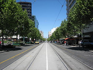
Swanston Street, Melbourne
Encyclopedia
Melbourne
Melbourne is the capital and most populous city in the state of Victoria, and the second most populous city in Australia. The Melbourne City Centre is the hub of the greater metropolitan area and the Census statistical division—of which "Melbourne" is the common name. As of June 2009, the greater...
, Australia
Australia
Australia , officially the Commonwealth of Australia, is a country in the Southern Hemisphere comprising the mainland of the Australian continent, the island of Tasmania, and numerous smaller islands in the Indian and Pacific Oceans. It is the world's sixth-largest country by total area...
. It is historically one of the main streets of central Melbourne, laid out in 1837 as part of the Hoddle Grid
Hoddle Grid
The Hoddle Grid is the layout of the streets in the centre of the central business district of Melbourne. Named after its designer, Robert Hoddle, the Grid was laid out in 1837, and later extended...
, the layout of major streets that makes up the central business district
Central business district
A central business district is the commercial and often geographic heart of a city. In North America this part of a city is commonly referred to as "downtown" or "city center"...
. It is named after Captain Charles Swanston
Charles Swanston
Charles Swanston merchant, banker and politician was a financial backer of the Port Phillip Association. He was born in Berwick upon Tweed, England the son of Robert and Rebecca Swanston...
, a Tasmania
Tasmania
Tasmania is an Australian island and state. It is south of the continent, separated by Bass Strait. The state includes the island of Tasmania—the 26th largest island in the world—and the surrounding islands. The state has a population of 507,626 , of whom almost half reside in the greater Hobart...
n banker and prominent member of the Port Phillip
Port Phillip
Port Phillip Port Phillip Port Phillip (also commonly referred to as Port Phillip Bay or (locally) just The Bay, is a large bay in southern Victoria, Australia; it is the location of Melbourne. Geographically, the bay covers and the shore stretches roughly . Although it is extremely shallow for...
Association.
Swanston Street runs roughly north to south, between Elizabeth Street
Elizabeth Street, Melbourne
Elizabeth Street is one of the main north-south streets in the central business district of Melbourne, Australia, part of the Hoddle Grid laid out in 1837.- Geography :...
to its west and Russell Street
Russell Street, Melbourne
Russell Street is a north-south street in the central business district of Melbourne, Australia, part of the Hoddle Grid laid out in 1837. At its southern end it intersects with Flinders Street and Federation Square, while at its northern end it becomes Lygon Street, a street famous for its...
to its east. The street runs through the middle of Melbourne's city centre, just to the east of the centre of the rectangular Hoddle Grid
Hoddle Grid
The Hoddle Grid is the layout of the streets in the centre of the central business district of Melbourne. Named after its designer, Robert Hoddle, the Grid was laid out in 1837, and later extended...
. To the south, it crosses the Princes Bridge
Princes Bridge, Melbourne
Princes Bridge, originally Prince's Bridge, is an important bridge in central Melbourne, Australia that spans the Yarra River. It is built on the site of one of the oldest river crossings in Australia. The bridge connects Swanston Street on the north bank of the Yarra River to St Kilda Road on the...
over the Yarra River
Yarra River
The Yarra River, originally Birrarung, is a river in east-central Victoria, Australia. The lower stretches of the river is where the city of Melbourne was established in 1835 and today Greater Melbourne dominates and influences the landscape of its lower reaches...
before becoming St Kilda Road
St Kilda Road, Melbourne
St Kilda Road is a street in Melbourne, Victoria, Australia. It is part of the locality of Melbourne which has the postcode of 3004 and along with Swanston Street forms a major spine of the city....
. As it runs north and leaves the CBD, it passes the University of Melbourne
University of Melbourne
The University of Melbourne is a public university located in Melbourne, Victoria. Founded in 1853, it is the second oldest university in Australia and the oldest in Victoria...
, and ends at the Melbourne General Cemetery
Melbourne General Cemetery
The Melbourne General Cemetery is a large necropolis located north of the city of Melbourne in the suburb of Carlton North.-History:...
. This section was originally named Madeline Street.
The street passes a number of iconic Melbourne landmarks, including the Capitol Theatre
Capitol Theatre, Melbourne
Opened in 1924, The Capitol Theatre is a spectacularly designed single screen cinema located in Melbourne, Australia . On 20 May 1999, it was purchased by Royal Melbourne Institute of Technology , and is currently used for both university lectures and cultural events such as film and comedy festivals...
, Manchester Unity Building
Manchester Unity Building
The Manchester Unity Building is a Art Deco skyscraper in Melbourne, Australia, constructed in 1932.-History:The site, on the north-west corner of the intersection of Collins Street and Swanston Street, was purchased by the Manchester Unity of Odd Fellows in 1928, reportedly for the sum of £250,000...
, St Paul's Cathedral
St Paul's Cathedral, Melbourne
St Paul's Cathedral, Melbourne, is the metropolitical and cathedral church of the Anglican Diocese of Melbourne, Victoria in Australia. It is the seat of the Anglican Archbishop of Melbourne and Metropolitan of the Province of Victoria...
, Federation Square
Federation Square
Federation Square is a civic centre and cultural precinct in the city of Melbourne, Victoria, Australia....
, Flinders Street Station
Flinders Street Station
Flinders Street Station is the central railway station of the suburban railway network of Melbourne, Victoria, Australia. It is on the corner of Flinders and Swanston Streets next to the Yarra River in the heart of the city, stretching from Swanston Street to Queen Street and covering two city...
, the Melbourne Town Hall
Melbourne Town Hall
Melbourne Town Hall is the central municipal building of the City of Melbourne, Australia, in the State of Victoria. It is located on the northeast corner of Swanston and Collins Streets, in the central business district. It is the seat of the Local Government Area of the City of Melbourne...
, the State Library of Victoria
State Library of Victoria
The State Library of Victoria is the central library of the state of Victoria, Australia, located in Melbourne. It is on the block bounded by Swanston, La Trobe, Russell, and Little Lonsdale streets, in the northern centre of the central business district...
, the City Square, the Melbourne Central and QV Village
Queen Victoria Village
Queen Victoria Village, generally known as QV Village or just QV, is a precinct in the central business district of Melbourne, Victoria, Australia...
shopping centres, Curtin House
Curtin House
Curtin House is a six storey Art Nouveau building on Swanston Street in the Melbourne CBD that hosts thai restaurant and bar Cookie, , a family owned and operated Kung Fu academy; , website developers , bookstore , rare record store and music venue - , which hosts cabaret, comedy, acoustic, blues,...
, the pub Young & Jackson as well as the Hi-Fi Bar, which is a prominent live music venue. Both the University of Melbourne
University of Melbourne
The University of Melbourne is a public university located in Melbourne, Victoria. Founded in 1853, it is the second oldest university in Australia and the oldest in Victoria...
and RMIT University
RMIT University
RMIT University is an Australian public university located in Melbourne, Victoria. It has two branches, referred to as RMIT University in Australia and RMIT International University in Vietnam....
are on Swanston Street.
History
Swanston Street was one of the main north-south streets originally laid out in the 1837 Hoddle GridHoddle Grid
The Hoddle Grid is the layout of the streets in the centre of the central business district of Melbourne. Named after its designer, Robert Hoddle, the Grid was laid out in 1837, and later extended...
. Originally carrying pedestrians and horse drawn cart, the street resembled many typical European avenues of the 19th century. By the end of the 19th century it was carrying one of the major tram lines through the city. By the advent of the automobile
Automobile
An automobile, autocar, motor car or car is a wheeled motor vehicle used for transporting passengers, which also carries its own engine or motor...
in the early 20th century, the street became a major thoroughfare, carrying automobile traffic between areas north of the city and St Kilda Road
St Kilda Road, Melbourne
St Kilda Road is a street in Melbourne, Victoria, Australia. It is part of the locality of Melbourne which has the postcode of 3004 and along with Swanston Street forms a major spine of the city....
throughout most of the 20th century.
Carbon monoxide
Carbon monoxide , also called carbonous oxide, is a colorless, odorless, and tasteless gas that is slightly lighter than air. It is highly toxic to humans and animals in higher quantities, although it is also produced in normal animal metabolism in low quantities, and is thought to have some normal...
pollution, homelessness
Homelessness
Homelessness describes the condition of people without a regular dwelling. People who are homeless are unable or unwilling to acquire and maintain regular, safe, and adequate housing, or lack "fixed, regular, and adequate night-time residence." The legal definition of "homeless" varies from country...
and loitering
Loitering
Loitering is the act of remaining in a particular public place for a protracted time. Under certain circumstances, it is illegal in various jurisdictions.-Prohibition and history:Loitering may be prohibited by local governments in several countries...
, and a plethora of discount stores, fast food outlets, sex shops and strip joints, throughout the later half of the 20th century.
In the 1990s
1990s
File:1990s decade montage.png|From left, clockwise: The Hubble Space Telescope floats in space after it was taken up in 1990; American F-16s and F-15s fly over burning oil fields and the USA Lexie in Operation Desert Storm, also known as the 1991 Gulf War; The signing of the Oslo Accords on...
it was closed to daytime private through traffic between Flinders
Flinders Street, Melbourne
Flinders Street is a notable street in Melbourne, Victoria, Australia. Running roughly parallel to the Yarra River, Flinders Street forms the southern edge of the Hoddle Grid. It is exactly one mile in length and one and half chains in width...
and La Trobe
La Trobe Street, Melbourne
La Trobe Street is a major street in the central business district of Melbourne, Victoria, Australia. It runs roughly from east to west and forms the northern boundary of the CBD ....
Streets, roughly half its length. This section is known as Swanston Street Walk. Swanston Street was redeveloped in 1992 with a number of public sculptures being established through the Percent for Art Program. The most famous of these statues is of a small bronze dog called Larry La Trobe
Larry La Trobe
Larry La Trobe is the name given to a popular, cast bronze statue of a dog situated on the northern end of Melbourne’s City Square...
by Melbourne artist, Pamela Irving
Pamela Irving
Pamela Irving is a prominent Australian Visual artist specialising in bronze, ceramic and mosaic sculptures as well as printmaking and copper etchings...
. By the turn of the 21st century, the street carried nine tram routes, with the frequency of trams being the highest in Melbourne.
In November 2008, newly elected Lord Mayor of Melbourne Robert Doyle
Robert Doyle
Robert Keith Bennett Doyle is an Australian politician and the 103rd Lord Mayor of Melbourne, elected on 30 November 2008...
proposed to return private vehicle traffic to the street. The move attracted opposition from the Public Transport Users Association
Public Transport Users Association
The Public Transport Users Association is a community-based public transport lobby group in Victoria, Australia, based in Melbourne.- History and Aims :...
, Australian Greens
Australian Greens
The Australian Greens, commonly known as The Greens, is an Australian green political party.The party was formed in 1992; however, its origins can be traced to the early environmental movement in Australia and the formation of the United Tasmania Group , the first Green party in the world, which...
and Bicycle Victoria
Bicycle Victoria
Bicycle Network Victoria is a community-based not-for-profit organisation, one of the largest cycling membership organisations in the world , whose mission is to get More People Cycling More Often. The name was changed from Bicycle Victoria to Bicycle Network Victoria in July 2011...
. This proposal was rejected and by January 2010, plans to make the entire length of Swanston Street in the city car free, were announced by the Lord Mayor himself, representing a complete backflip on the issue.
Route
The street runs in a straight line, north-northwest to south-southeast, between Elizabeth StreetElizabeth Street, Melbourne
Elizabeth Street is one of the main north-south streets in the central business district of Melbourne, Australia, part of the Hoddle Grid laid out in 1837.- Geography :...
to its west and Russell Street
Russell Street, Melbourne
Russell Street is a north-south street in the central business district of Melbourne, Australia, part of the Hoddle Grid laid out in 1837. At its southern end it intersects with Flinders Street and Federation Square, while at its northern end it becomes Lygon Street, a street famous for its...
to its east. The street runs through the middle of Melbourne's city centre, just to the east of the centre of the rectangular Hoddle Grid
Hoddle Grid
The Hoddle Grid is the layout of the streets in the centre of the central business district of Melbourne. Named after its designer, Robert Hoddle, the Grid was laid out in 1837, and later extended...
. To the south, it crosses the Princes Bridge
Princes Bridge, Melbourne
Princes Bridge, originally Prince's Bridge, is an important bridge in central Melbourne, Australia that spans the Yarra River. It is built on the site of one of the oldest river crossings in Australia. The bridge connects Swanston Street on the north bank of the Yarra River to St Kilda Road on the...
over the Yarra River
Yarra River
The Yarra River, originally Birrarung, is a river in east-central Victoria, Australia. The lower stretches of the river is where the city of Melbourne was established in 1835 and today Greater Melbourne dominates and influences the landscape of its lower reaches...
before becoming St Kilda Road
St Kilda Road, Melbourne
St Kilda Road is a street in Melbourne, Victoria, Australia. It is part of the locality of Melbourne which has the postcode of 3004 and along with Swanston Street forms a major spine of the city....
. As it runs north and leaves the CBD, it passes the University of Melbourne
University of Melbourne
The University of Melbourne is a public university located in Melbourne, Victoria. Founded in 1853, it is the second oldest university in Australia and the oldest in Victoria...
, and ends at the Melbourne General Cemetery
Melbourne General Cemetery
The Melbourne General Cemetery is a large necropolis located north of the city of Melbourne in the suburb of Carlton North.-History:...
.
Transport
Nine tram routes currently run along the street, with the frequency of trams being the highest in Melbourne. Along it are located two of the busiest railway stations in the city; Flinders Street StationFlinders Street Station
Flinders Street Station is the central railway station of the suburban railway network of Melbourne, Victoria, Australia. It is on the corner of Flinders and Swanston Streets next to the Yarra River in the heart of the city, stretching from Swanston Street to Queen Street and covering two city...
at its southern end, which is the hub of the suburban railway network; and Melbourne Central station
Melbourne Central railway station
Melbourne Central is an underground station in the metro railway network of Melbourne, Australia. It is one of five stations on the City Loop, which encircles the central business district. The station is under La Trobe Street, between Swanston and Elizabeth Streets, on the northern edge of the CBD...
, an underground station beneath the Melbourne Central
Melbourne Central
Melbourne Central may refer to:*Melbourne Central Shopping Centre*Melbourne Central railway station...
area at La Trobe Street. Swanston Street is also a major route for commuting cyclists from the University of Melbourne and the northern suburbs, through the city, joining up to the bike lanes on St Kilda Road, and the Capital City Trail
Capital City Trail
The Capital City Trail is a shared use path for cyclists and pedestrians, which circles the Melbourne city centre and some inner eastern and northern suburbs of Melbourne, Victoria, Australia....
on the Southbank
Southbank, Victoria
Southbank is an inner city suburb of Melbourne, Victoria, Australia located direct south of the Yarra River opposite Melbourne's Hoddle Grid. The northernmost area is considered part of the Central Business District and Central Activities District of the city. Its Local Government Area are the...
of the Yarra River.
The parking of tour buses along the street caused controversy in September 2008 when a young cyclist was killed by a bus as it turned out of a parking spot. There had previously been calls to the council to relocate the large buses from the street where there was little space between buses and trams.
Use for marches, rallies and protests
Many protests involve the use of Swanston Street, resulting in road closures. It is also used for the annual Anzac DayANZAC Day
Anzac Day is a national day of remembrance in Australia and New Zealand, commemorated by both countries on 25 April every year to honour the members of the Australian and New Zealand Army Corps who fought at Gallipoli in the Ottoman Empire during World War I. It now more broadly commemorates all...
parade, which passes through much of the city centre, but uses Swanston Street as a centrepiece on its way to the Shrine of Remembrance
Shrine of Remembrance
The Shrine of Remembrance, located in Kings Domain on St Kilda Road, Melbourne, Australia was built as a memorial to the men and women of Victoria who served in World War I and is now a memorial to all Australians who have served in war...
in St Kilda Road.
In media
Swanston Street was the shooting location for the 1976 video for AC/DC's song "It's a Long Way to the Top (If You Wanna Rock 'n' Roll)It's A Long Way To The Top (If You Wanna Rock 'n' Roll)
"It's a Long Way to the Top " is a song by Australian hard rock band AC/DC. It is the first track of the group's album T.N.T., released in December 1975, and was written by Angus Young, Malcolm Young and Bon Scott...
".
It is also referenced in The Distillers
The Distillers
The Distillers were an American punk rock band formed in Los Angeles in 1998. They released their first two albums on Hellcat Records/Epitaph Records before moving to Sire, part of the Warner Music Group. The Distillers were originally formed by Australian-born Brody Armstrong , a woman with a...
' song "Dismantle Me", as singer Brody Dalle
Brody Dalle
Brody Dalle is an Australian-born American singer, songwriter and guitarist. She rose to fame as lead singer/guitarist for the punk rock band The Distillers and currently fronts Spinnerette....
is originally from Melbourne
Melbourne
Melbourne is the capital and most populous city in the state of Victoria, and the second most populous city in Australia. The Melbourne City Centre is the hub of the greater metropolitan area and the Census statistical division—of which "Melbourne" is the common name. As of June 2009, the greater...
.
Car free proposals
Once one of the busiest roads in Melbourne, carrying large private automobile volumes throughout the 20th century, Swanston Street has been partially car free since 1992, with exemptions for small freight, buses and private automobiles during certain times of the day. Since the 1990s, proposals for the street to become entirely car free have continuously gained support and momentum.On January 27, 2010, it was announced that the entire length of Swanston Street would become car free. The $25.6 million proposal includes plans for several city squares along the street and several large tram stops. Aside from trams, the only motorised vehicular access will be small-scale freight at certain times, and emergency vehicles.