
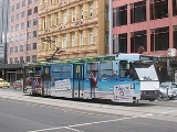
Melbourne tram route 70
Encyclopedia
Tram
route 70 is a public transport
service in Melbourne
, Victoria
, Australia
. It is operated by Camberwell Depot and runs from the Waterfront City Docklands to Wattle Park
in Box Hill South
. Like most tram routes in Melbourne, it is entirely within Metcard
ticketing Zone 1.
The route runs along Docklands Drive, Harbour Esplanade, Flinders Street
in the city, behind Melbourne Park
(alongside the railway tracks) at Richmond
and then links up to Swan Street
, running along Riversdale Road through Hawthorn
and Camberwell
to the eastern end of Wattle Park, terminating at Elgar Road.
At the city end the tram once ran along Swan Street until reaching the Swan Street Bridge, then ran along Batman Avenue following the Yarra River until it reached the city terminus beside Princes Bridge, opposite Flinders Street Station. The current route was adopted as part of the Exhibition Street Extension project announced by the State Government in April 1998 and completed in October 1999, where a four-lane divided road was built over the Jolimont railyards, enabling Batman Avenue west of Melbourne Park to be closed.
(stop D11), then runs via:
Ends at Elgar Road, Wattle Park (stop 61).
Tram
A tram is a passenger rail vehicle which runs on tracks along public urban streets and also sometimes on separate rights of way. It may also run between cities and/or towns , and/or partially grade separated even in the cities...
route 70 is a public transport
Public transport
Public transport is a shared passenger transportation service which is available for use by the general public, as distinct from modes such as taxicab, car pooling or hired buses which are not shared by strangers without private arrangement.Public transport modes include buses, trolleybuses, trams...
service in Melbourne
Melbourne
Melbourne is the capital and most populous city in the state of Victoria, and the second most populous city in Australia. The Melbourne City Centre is the hub of the greater metropolitan area and the Census statistical division—of which "Melbourne" is the common name. As of June 2009, the greater...
, Victoria
Victoria (Australia)
Victoria is the second most populous state in Australia. Geographically the smallest mainland state, Victoria is bordered by New South Wales, South Australia, and Tasmania on Boundary Islet to the north, west and south respectively....
, Australia
Australia
Australia , officially the Commonwealth of Australia, is a country in the Southern Hemisphere comprising the mainland of the Australian continent, the island of Tasmania, and numerous smaller islands in the Indian and Pacific Oceans. It is the world's sixth-largest country by total area...
. It is operated by Camberwell Depot and runs from the Waterfront City Docklands to Wattle Park
Wattle Park, Melbourne
Wattle Park is a public park in Melbourne, Australia, located in the suburb of Burwood. It is known for its plantation of 12,000 wattle trees. It is currently maintained by Parks Victoria....
in Box Hill South
Box Hill South, Victoria
Box Hill South is a suburb in Melbourne, Victoria, Australia, 14 km east from Melbourne's central business district. Its Local Government Area is the City of Whitehorse...
. Like most tram routes in Melbourne, it is entirely within Metcard
Metcard
"OneLink" redirects here. For the computer/cable company, see OneLink Communications.Metcard is the brand name of an integrated ticketing system used to access public transport in Melbourne, Australia. It is a universal ticket which allows users to ride on the city's Metlink network, consisting of...
ticketing Zone 1.
The route runs along Docklands Drive, Harbour Esplanade, Flinders Street
Flinders Street, Melbourne
Flinders Street is a notable street in Melbourne, Victoria, Australia. Running roughly parallel to the Yarra River, Flinders Street forms the southern edge of the Hoddle Grid. It is exactly one mile in length and one and half chains in width...
in the city, behind Melbourne Park
Melbourne Park
Melbourne Park is a sports venue in the Melbourne Sports and Entertainment Precinct in Melbourne, Victoria, Australia. Since 1988, Melbourne Park has been home of the Australian Open in tennis, which is played annually in January...
(alongside the railway tracks) at Richmond
Richmond, Victoria
Richmond is a suburb in Melbourne, Victoria, Australia, 3 km south-east from Melbourne's central business district. Its Local Government Area is the City of Yarra...
and then links up to Swan Street
Swan Street, Melbourne
Swan Street is a major street running through the Melbourne suburbs of Richmond, Cremorne and Burnley. The section of the street between Punt Road and Alexandra Avenue is now known as Olympic Boulevard....
, running along Riversdale Road through Hawthorn
Hawthorn, Victoria
Hawthorn is a suburb in Melbourne, Victoria, Australia, east from Melbourne's central business district. Its Local Government Area is the City of Boroondara...
and Camberwell
Camberwell, Victoria
Camberwell is a suburb in Melbourne, Victoria, Australia, 9 km east from Melbourne's central business district. Its Local Government Area is the City of Boroondara. At the 2006 Census, Camberwell had a population of 19,637....
to the eastern end of Wattle Park, terminating at Elgar Road.
At the city end the tram once ran along Swan Street until reaching the Swan Street Bridge, then ran along Batman Avenue following the Yarra River until it reached the city terminus beside Princes Bridge, opposite Flinders Street Station. The current route was adopted as part of the Exhibition Street Extension project announced by the State Government in April 1998 and completed in October 1999, where a four-lane divided road was built over the Jolimont railyards, enabling Batman Avenue west of Melbourne Park to be closed.
Route
Starts at Waterfront City Melbourne DocklandsMelbourne Docklands
Docklands is an inner city suburb in Melbourne, Victoria, Australia occupying an area extending up to 2 km west of and adjacent to Melbourne's Central Business District . Its Local Government Area is the City of Melbourne...
(stop D11), then runs via:
- Docklands Drive/Harbour Esplanade, Southern Star Observation WheelSouthern Star Observation WheelThe Southern Star is a currently nonoperational Ferris wheel in the Waterfront City precinct at Melbourne Docklands in Melbourne, the state capital of Victoria, Australia. It is tall, the equivalent of a forty storey building. It opened in December 2008, but then closed the following month due to...
- La Trobe StreetLa Trobe Street, MelbourneLa Trobe Street is a major street in the central business district of Melbourne, Victoria, Australia. It runs roughly from east to west and forms the northern boundary of the CBD ....
, Etihad Stadium, tram route 30Melbourne tram route 30Tram route 30 is a public transport service in Melbourne, Victoria, Australia. It runs from St Vincents Plaza to Etihad Stadium. It only runs on weekdays, during daylight hours and is one of three fare paying routes to use heritage W class trams....
(stop D2)
- La Trobe Street
- Flinders StreetFlinders Street, MelbourneFlinders Street is a notable street in Melbourne, Victoria, Australia. Running roughly parallel to the Yarra River, Flinders Street forms the southern edge of the Hoddle Grid. It is exactly one mile in length and one and half chains in width...
(stop D6-8)- Melbourne Exhibition CentreMelbourne Exhibition and Convention CentreThe Melbourne Convention and Exhibition Centre is the name given to two adjacent buildings next to the Yarra River in South Wharf, an inner-city suburb of Melbourne, Victoria, Australia...
(stop D6)
- Melbourne Exhibition Centre
- Flinders Street
- Spencer StreetSpencer Street, MelbourneSpencer Street is a major street in the central business district of Melbourne, Victoria, Australia. It is named for John Spencer, 3rd Earl Spencer, Chancellor of the Exchequer under Lord Melbourne, the Prime Minister of the United Kingdom....
, tram routes 75Melbourne tram route 75Tram route 75 is a public transport service in Melbourne, Victoria, Australia. It runs from the corner of Spencer Street and La Trobe Street in the city centre to Vermont South in the eastern suburbs....
, 96Melbourne tram route 96Melbourne tram route 96 is a public transport tram and light rail route in Melbourne, Victoria, Australia.It is one of Melbourne's busiest tram route carrying 39,700 passengers a day with a frequency of every 10 minutes or less during peak...
, 109Melbourne tram route 109Tram route 109 or simply The 109 is a public transport service in Melbourne, Victoria, Australia. It runs between a terminus in Box Hill and a terminus near Station Pier in Port Melbourne...
and 112Melbourne tram route 112Tram route 112 is a public transport service in Melbourne, Victoria, Australia. It runs from West Preston, in the northern suburbs to St Kilda.Like most tram routes in Melbourne, it falls within Metcard/myki ticketing Zone 1....
(stop 1) - King StreetKing Street, MelbourneKing Street is a main street in the Melbourne central business district. King Street is part of the Pacific Highway, and used to be part of National Route 1 until the city by-pass road linking the Monash Freeway with the Westgate Freeway was completed...
, Melbourne AquariumMelbourne AquariumMelbourne Aquarium is a Southern Ocean and Antarctic aquarium in central Melbourne, Australia. It is located on the banks of the Yarra River beside and under the Flinders Street Viaduct and the King Street Bridge.-History:...
(stop 2) - Market StreetMarket Street, MelbourneMarket Street is one of the north-south streets in the central business district of Melbourne, Australia, part of the Hoddle Grid laid out in 1837....
, Banana Alley VaultsBanana Alley, MelbourneThe Banana Alley Vaults are near the Flinders Street Station in Melbourne, Australia and extend onto the North Bank of the Yarra River.Built in 1891-92, whey were originally known as the Viaduct Buildings, and were built in conjunction with the tracks of the Flinders Street Viaduct that run overhead...
, tram route 55Melbourne tram route 55Tram route 55 is a public transport service in Melbourne, Victoria, Australia. It runs from the corner of Bell Street and Melville Road in West Coburg to the Domain Road Interchange - Domain Road and St Kilda Road east of the city....
(stop 3) - Elizabeth StreetElizabeth Street, MelbourneElizabeth Street is one of the main north-south streets in the central business district of Melbourne, Australia, part of the Hoddle Grid laid out in 1837.- Geography :...
, tram routes 19Melbourne tram route 19Tram route 19 is a public transport service in Melbourne, Victoria, Australia. It runs from Flinders Street in the city centre to North Coburg in the northern suburbs. It runs through the suburbs of Melbourne, Parkville, Brunswick, Coburg, and Coburg North...
, 57Melbourne tram route 57Tram route 57 is a public transport service in Melbourne, Victoria, Australia. It runs from the corner of Flinders Street and Elizabeth Street in the city centre to West Maribyrnong in the inner Western suburbs....
and 59Melbourne tram route 59Tram route 59 is a public transport service in Melbourne, Victoria, Australia. It runs from the intersection of Flinders Street and Elizabeth Street in the city centre to Airport West in the north western suburbs....
(stop 4) - Flinders Street StationFlinders Street StationFlinders Street Station is the central railway station of the suburban railway network of Melbourne, Victoria, Australia. It is on the corner of Flinders and Swanston Streets next to the Yarra River in the heart of the city, stretching from Swanston Street to Queen Street and covering two city...
(stop 4-5) - Federation SquareFederation SquareFederation Square is a civic centre and cultural precinct in the city of Melbourne, Victoria, Australia....
, St Paul's CathedralSt Paul's Cathedral, MelbourneSt Paul's Cathedral, Melbourne, is the metropolitical and cathedral church of the Anglican Diocese of Melbourne, Victoria in Australia. It is the seat of the Anglican Archbishop of Melbourne and Metropolitan of the Province of Victoria...
, tram routes 1Melbourne tram route 1Tram route 1 is a public transport service in Melbourne, Victoria, Australia. It runs from the terminus at Nicholson Street and Bell Street in East Coburg to the corner of Victoria Avenue and Beaconsfield Parade in Albert Park....
, 3Melbourne tram route 3Tram route 3 is a public transport service in Melbourne, Victoria, Australia. It runs from the University of Melbourne north of the city centre to Malvern East in the eastern suburbs....
, 5Melbourne tram route 5Tram route 5 is a public transport service in Melbourne, Victoria, Australia. It runs from the University of Melbourne north of the city centre to Malvern East in the eastern suburbs. The destination is, however, displayed as Malvern, although the route technically ends within Malvern East...
, 6Melbourne tram route 6Tram route 6 is a public transport service in Melbourne, Victoria, Australia. It runs from the University of Melbourne in the city centre to Glen Iris in the eastern suburbs....
, 8Melbourne tram route 8Tram route 8 is a public transport service in Melbourne, Victoria, Australia. It runs from Toorak to Moreland through the suburbs of Carlton and South Yarra...
, 16Melbourne tram route 16Tram route 16 is a public transport service in Melbourne, Victoria, Australia. It runs from the University of Melbourne in the city centre to Kew in the eastern suburbs. It runs through the suburbs of Melbourne, St Kilda, Balaclava, Malvern, and Kew...
, 64Melbourne tram route 64Tram route 64 is a public transport service in Melbourne, Victoria, Australia. It runs from the University of Melbourne in the city centre to East Brighton in the southern suburbs. It runs through the suburbs of Melbourne, Windsor, Caulfield, and Brighton East...
, 67Melbourne tram route 67The Melbourne Tram Route 67 is an Australian tram route which runs back and forth from Carnegie to the University of Melbourne.The route starts at the Carnegie terminus, located in Trugininni Road at the corner of Koornang Road, and travels via Glen Huntly Road, Brighton Road, St Kilda Road and...
and 72Melbourne tram route 72Tram route 72 is a public transport service in Melbourne, Victoria, Australia. It runs from the University of Melbourne in the city centre to Camberwell in the eastern suburbs. It runs through the suburbs of Melbourne, South Yarra, Toorak, Malvern, Glen Iris, and Camberwell...
(stop 5) - Russell StreetRussell Street, MelbourneRussell Street is a north-south street in the central business district of Melbourne, Australia, part of the Hoddle Grid laid out in 1837. At its southern end it intersects with Flinders Street and Federation Square, while at its northern end it becomes Lygon Street, a street famous for its...
, Forum TheatreForum TheatreThe Forum Theatre is a theatre located on the corner of Flinders Street and Russell Street in the central business district of Melbourne, Australia. The building was designed by American architect John Eberson, who has designed many theatres across the globe, along with a local architectural firm...
(stop 6) - Exhibition StreetExhibition Street, MelbourneExhibition Street is a major street in the central business district of Melbourne, Australia. The street is named after the World Heritage listed Royal Exhibition Building, which is located in the Carlton Gardens.- Geography :...
, tram route 75Melbourne tram route 75Tram route 75 is a public transport service in Melbourne, Victoria, Australia. It runs from the corner of Spencer Street and La Trobe Street in the city centre to Vermont South in the eastern suburbs....
(stop 7)
- Spencer Street
- Melbourne Park
- Rod Laver ArenaRod Laver ArenaRod Laver Arena is a tennis stadium that is part of the Melbourne Park complex located in Melbourne, Victoria, Australia, and has been the main venue for the Australian Open in tennis since 1988, replacing the ageing Kooyong Stadium...
(stop 7B) - MCGMelbourne Cricket GroundThe Melbourne Cricket Ground is an Australian sports stadium located in Yarra Park, Melbourne and is home to the Melbourne Cricket Club. It is the tenth largest stadium in the world, the largest in Australia, the largest stadium for playing cricket, and holds the world record for the highest light...
, Hisense Arena and Olympic ParkOlympic Park StadiumOlympic Park Stadium was a multi-purpose outdoor stadium located on Olympic Boulevard in inner Melbourne. The stadium was built as an athletics training venue for the 1956 Olympics, a short distance from the MCG, which served as the Olympic Stadium...
(stop 7C)
- Rod Laver Arena
- Swan Street
- Cremorne Street, Richmond stationRichmond railway station, MelbourneRichmond is a railway station in Melbourne, Victoria, Australia, located in the suburb of Richmond. It is classed as a Premium Station and is in Metcard Zone 1.-Facilities:...
(stop 8) - Church Street, tram routes 78Melbourne tram route 78Tram route 78 is a public transport service in Melbourne, Victoria, Australia. The route starts at the Victoria St terminus , then runs along Church St, Richmond, crossing Bridge Rd and Swan St . It continues over the Yarra River along Chapel St, crossing Toorak Rd at stop 49...
and 79Melbourne tram route 79Tram route 79 is a public transport service in Melbourne, Victoria, Australia. It runs from North Richmond to St Kilda Beach through the suburbs of South Yarra, Prahran, Windsor, Balaclava, and St, Kilda. Like most tram routes in Melbourne, it is entirely within Metcard ticketing Zone 1...
(stop 11) - Burnley Street, Burnley station (stop 14)
- Cremorne Street, Richmond station
- Riversdale Road
- Glenferrie RoadGlenferrie Road, MelbourneGlenferrie Road is a major north–south thoroughfare in Melbourne, Australia.It runs from Kew to Malvern, and includes major shopping districts at both Hawthorn and Malvern.Tram route 16 runs along the entire length of Glenferrie Road...
, tram route 16Melbourne tram route 16Tram route 16 is a public transport service in Melbourne, Victoria, Australia. It runs from the University of Melbourne in the city centre to Kew in the eastern suburbs. It runs through the suburbs of Melbourne, St Kilda, Balaclava, Malvern, and Kew...
(stop 32) - Burke RoadBurke Road, MelbourneBurke Road is a major north-south thoroughfare in Melbourne, Australia. It runs from Ivanhoe to Caulfield, and includes the major shopping district at Camberwell...
, tram routes 72Melbourne tram route 72Tram route 72 is a public transport service in Melbourne, Victoria, Australia. It runs from the University of Melbourne in the city centre to Camberwell in the eastern suburbs. It runs through the suburbs of Melbourne, South Yarra, Toorak, Malvern, Glen Iris, and Camberwell...
and 75Melbourne tram route 75Tram route 75 is a public transport service in Melbourne, Victoria, Australia. It runs from the corner of Spencer Street and La Trobe Street in the city centre to Vermont South in the eastern suburbs....
(stop 40) - Riversdale station (stop 46)
- Glenferrie Road
Ends at Elgar Road, Wattle Park (stop 61).