

Victoria Street, Melbourne
Encyclopedia
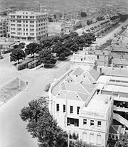
 Victoria Street is one of the major thoroughfares of inner Melbourne
Melbourne
Melbourne is the capital and most populous city in the state of Victoria, and the second most populous city in Australia. The Melbourne City Centre is the hub of the greater metropolitan area and the Census statistical division—of which "Melbourne" is the common name. As of June 2009, the greater...
. Running east to west, Victoria Street touches the Hoddle Grid
Melbourne city centre
Melbourne City Centre is an area of Melbourne in Victoria, Australia. It is not to be confused with the larger local government area of the City of Melbourne...
at the intersection of La Trobe Street
La Trobe Street, Melbourne
La Trobe Street is a major street in the central business district of Melbourne, Victoria, Australia. It runs roughly from east to west and forms the northern boundary of the CBD ....
and Spring Street
Spring Street, Melbourne
Spring Street is a major street in the central business district of Melbourne, Victoria, Australia. It runs roughly north-south, and is the easternmost street in the Hoddle Grid. The street travels from Flinders Street in the south, to La Trobe Street and the Carlton Gardens in the north...
, opposite the Carlton Gardens
Carlton Gardens, Melbourne
The Carlton Gardens is a World Heritage Site located on the northeastern edge of the Central Business District in the suburb of Carlton, in Melbourne, Victoria, Australia....
. It runs from its terminus at the intersection of Munster Terrace in North Melbourne
North Melbourne, Victoria
North Melbourne is a large inner city suburb of Melbourne, Victoria, Australia, 2 km north-west from Melbourne's central business district. It is bounded by the CityLink freeway to the west, Victoria Street to the south, O'Connell and Peel Streets to the east and Flemington Road to the north. Its...
until it reaches the Yarra River
Yarra River
The Yarra River, originally Birrarung, is a river in east-central Victoria, Australia. The lower stretches of the river is where the city of Melbourne was established in 1835 and today Greater Melbourne dominates and influences the landscape of its lower reaches...
. The road crosses the river over Victoria Bridge
Victoria Bridge, Melbourne
The Victoria Bridge is a bridge over the Yarra River between Richmond and Hawthorn, Melbourne, Australia. It carries Victoria Street across the Yarra....
, then continues as Barkers Road until it terminates at Burke Road
Burke Road, Melbourne
Burke Road is a major north-south thoroughfare in Melbourne, Australia. It runs from Ivanhoe to Caulfield, and includes the major shopping district at Camberwell...
. Technically, it is named Victoria Parade between its intersections with Spring Street and Hoddle Street
Hoddle Highway
Hoddle Highway is an urban highway in Melbourne linking CityLink and the Eastern Freeway, allotted metropolitan route . The name "Hoddle Highway" is almost completely unknown to most drivers - who refer instead to its constituent parts: Hoddle Street and Punt Road.It starts at the Eastern Freeway...
, where it becomes a divided road with a reservation down the middle.
West Melbourne, Victoria
West Melbourne is an inner city suburb of Melbourne, Victoria, Australia, 3 km north-west from Melbourne's central business district. Its Local Government Area is the City of Melbourne...
, North Melbourne
North Melbourne, Victoria
North Melbourne is a large inner city suburb of Melbourne, Victoria, Australia, 2 km north-west from Melbourne's central business district. It is bounded by the CityLink freeway to the west, Victoria Street to the south, O'Connell and Peel Streets to the east and Flemington Road to the north. Its...
, Melbourne
Melbourne city centre
Melbourne City Centre is an area of Melbourne in Victoria, Australia. It is not to be confused with the larger local government area of the City of Melbourne...
, Carlton
Carlton, Victoria
Carlton is an inner city suburb of Melbourne, Victoria, Australia, 2 km north from Melbourne's central business district. Its Local Government Area is the City of Melbourne...
, East Melbourne
East Melbourne, Victoria
East Melbourne is a suburb in Melbourne, Victoria, Australia, adjacent to Melbourne's central business district. Its Local Government Area is the City of Melbourne. At the 2006 Census, East Melbourne had a population of 4,330....
, Fitzroy
Fitzroy, Victoria
Fitzroy is an inner city suburb of Melbourne, Victoria, Australia, 2 km north-east from Melbourne's central business district. Its Local Government Area is the City of Yarra. Its borders are Alexandra Parade , Victoria Parade , Smith Street and Nicholson Street. Fitzroy is Melbourne's...
, Collingwood
Collingwood, Victoria
Collingwood is an inner city suburb of Melbourne, Victoria, Australia, 3 km north-east from Melbourne's central business district. Its Local Government Area is the City of Yarra...
, Richmond
Richmond, Victoria
Richmond is a suburb in Melbourne, Victoria, Australia, 3 km south-east from Melbourne's central business district. Its Local Government Area is the City of Yarra...
and Abbotsford
Abbotsford, Victoria
Abbotsford is a suburb in Melbourne, Victoria, Australia, 2 km east from Melbourne's central business district. Its Local Government Area is the City of Yarra. At the 2006 Census, Abbotsford had a population of 4,327....
. In addition to the Carlton Gardens, several other Melbourne landmarks are located on Victoria Street, including RMIT University
RMIT University
RMIT University is an Australian public university located in Melbourne, Victoria. It has two branches, referred to as RMIT University in Australia and RMIT International University in Vietnam....
, the Royal Exhibition Building
Royal Exhibition Building
The Royal Exhibition Building is a World Heritage Site-listed building in Melbourne, Australia, completed in 1880. It is located at 9 Nicholson Street in the Carlton Gardens, flanked by Victoria, Nicholson, Carlton and Rathdowne Streets, at the north-eastern edge of the central business district...
, St Vincent's Hospital
St Vincent's Hospital, Melbourne
St Vincent's Hospital, Melbourne is the major hospital in Fitzroy, Melbourne, Australia.It is operated by the St Vincent's Health service, previously known as the Sisters of Charity Health Service, Melbourne...
, Queen Victoria Market
Queen Victoria Market
The Queen Victoria Market is a major landmark in Melbourne, Australia, and at around seven hectares is the largest open air market in the Southern Hemisphere. The Market is significant to Melbourne's culture and heritage and has been listed on the Victorian Heritage Register...
, the Eastern Hill Fire Station
Eastern Hill Fire Station
Eastern Hill Fire Station is the central fire station of Melbourne, Australia, located in on the corner of Victoria Parade and Gisborne Street, opposite St Peter's, Eastern Hill, one of the highest points in the city of Melbourne...
and the Victorian Trades Hall
Victorian Trades Hall
Victorian Trades Hall is a Trades Hall building located in the suburb of Carlton, Melbourne, Victoria, Australia, and home to the Victorian Trades Hall Council....
. Before its relocation to Westgarth
Westgarth, Victoria
Westgarth is a locality in Melbourne, Victoria, Australia. It is in the Local Government Area of the City of Darebin. It is situated 4 or 5 km from Melbourne's central business district, just north of Clifton Hill, and a few hundred metres south of the main part of Northcote...
, the Valhalla Cinema
Valhalla Cinema, Melbourne
The Valhalla Cinema was a repertory and arthouse movie theatre in Melbourne, Australia. Noted for audience participation films, it was named for Valhalla, the "Hall of the slain" in Norse mythology.-History:...
was located in Victoria Street, Richmond.
Victoria Street is well served by public transport
Public transport
Public transport is a shared passenger transportation service which is available for use by the general public, as distinct from modes such as taxicab, car pooling or hired buses which are not shared by strangers without private arrangement.Public transport modes include buses, trolleybuses, trams...
, with several tram
Trams in Melbourne
The Melbourne tramway network is a major form of public transport in Melbourne, the capital city of the state of Victoria, Australia. , the network consisted of of track, 487 trams, 28 routes, and 1,773 tram stops. It was therefore the largest urban tramway network in the world, ahead of the...
routes running along portions of its length, including the 24
Melbourne tram route 24
Tram route 24 is a public transport service in Melbourne, Victoria, Australia, which runs from La Trobe Street in the city centre, to North Balwyn. Like most tram routes in Melbourne, it falls within Metcard ticketing Zone 1....
, 42, 57
Melbourne tram route 57
Tram route 57 is a public transport service in Melbourne, Victoria, Australia. It runs from the corner of Flinders Street and Elizabeth Street in the city centre to West Maribyrnong in the inner Western suburbs....
and 109
Melbourne tram route 109
Tram route 109 or simply The 109 is a public transport service in Melbourne, Victoria, Australia. It runs between a terminus in Box Hill and a terminus near Station Pier in Port Melbourne...
routes. In addition, its western end is located nearby North Melbourne railway station
North Melbourne railway station
North Melbourne is a railway station located on the northern edge of the central business district of Melbourne, Australia. The station is the point through which pass the west and north-west bound Craigieburn, Flemington Racecourse, Sydenham, Upfield, Werribee and Williamstown suburban railway...
, and North Richmond railway station near its intersection with Hoddle Street.
The Richmond/Abbotsford stretch of Victoria Street is also one of Melbourne's better known restaurant
Restaurant
A restaurant is an establishment which prepares and serves food and drink to customers in return for money. Meals are generally served and eaten on premises, but many restaurants also offer take-out and food delivery services...
strips, hosting many Vietnam
Vietnam
Vietnam – sometimes spelled Viet Nam , officially the Socialist Republic of Vietnam – is the easternmost country on the Indochina Peninsula in Southeast Asia. It is bordered by China to the north, Laos to the northwest, Cambodia to the southwest, and the South China Sea –...
ese restaurants and grocery store
Grocery store
A grocery store is a store that retails food. A grocer, the owner of a grocery store, stocks different kinds of foods from assorted places and cultures, and sells these "groceries" to customers. Large grocery stores that stock products other than food, such as clothing or household items, are...
s, and also to the Victoria Gardens Shopping Centre
Victoria Gardens Shopping Centre
Victoria Gardens is a regional shopping centre located in Richmond, Victoria, Australia approximately east of Melbourne's central business district. It is located on the corner of Victoria and Burnley Streets, Richmond at the eastern end of the Richmond commercial, retail and residential precinct...
.
Other Victoria Streets
Victoria street was named during the reign of Queen VictoriaVictoria of the United Kingdom
Victoria was the monarch of the United Kingdom of Great Britain and Ireland from 20 June 1837 until her death. From 1 May 1876, she used the additional title of Empress of India....
, who at that time was also the ruler of Australia. Due to a mixture of her popularity and a certain patriotism about their state, many developers and local councillors named streets in their localities Victoria Street. Nearly all of Melbourne's oldest suburbs contain a Victoria Street, most of them dating from this era.
See also
- Victoria Bridge, MelbourneVictoria Bridge, MelbourneThe Victoria Bridge is a bridge over the Yarra River between Richmond and Hawthorn, Melbourne, Australia. It carries Victoria Street across the Yarra....