
Melbourne tram route 59
Encyclopedia
Tram
route 59 is a public transport service in Melbourne
, Victoria
, Australia
. It runs from the intersection of Flinders Street
and Elizabeth Street
in the city centre to Airport West
in the north western suburbs.
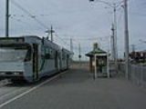
Like most Melbourne tram routes, route 59 operates entirely in Metcard
ticketing Zone 1. The route is primarily operated by B2 class trams from Essendon tram depot, and occasional Z3 class tram when B2 class trams are required elsewhere.
The route runs along Elizabeth Street in the city, Flemington Road
in Parkville
, Mount Alexander Road through Flemington
, Ascot Vale
and Moonee Ponds
, Pascoe Vale Road through Moonee Ponds and Essendon
, Fletcher Street in Essendon, Mount Alexander Road in Essendon, Keilor Road through Essendon North
and Niddrie
, and Matthews Avenue in Airport West where it terminates at the corner of Matthews Avenue and Rodd Road.
The tram does not go to Melbourne Airport
; its destination boards state "Airport West
" as this is the name of the suburb where the tram terminates. That suburb is so named as it lies west of Essendon Airport
.
on route 59.
Starts at intersection of Flinders and Elizabeth Streets, opposite Flinders Street Station
(stop 1), then runs via:
Ends at Westfield Airport West
(stop 59).
Tram
A tram is a passenger rail vehicle which runs on tracks along public urban streets and also sometimes on separate rights of way. It may also run between cities and/or towns , and/or partially grade separated even in the cities...
route 59 is a public transport service in Melbourne
Melbourne
Melbourne is the capital and most populous city in the state of Victoria, and the second most populous city in Australia. The Melbourne City Centre is the hub of the greater metropolitan area and the Census statistical division—of which "Melbourne" is the common name. As of June 2009, the greater...
, Victoria
Victoria (Australia)
Victoria is the second most populous state in Australia. Geographically the smallest mainland state, Victoria is bordered by New South Wales, South Australia, and Tasmania on Boundary Islet to the north, west and south respectively....
, Australia
Australia
Australia , officially the Commonwealth of Australia, is a country in the Southern Hemisphere comprising the mainland of the Australian continent, the island of Tasmania, and numerous smaller islands in the Indian and Pacific Oceans. It is the world's sixth-largest country by total area...
. It runs from the intersection of Flinders Street
Flinders Street, Melbourne
Flinders Street is a notable street in Melbourne, Victoria, Australia. Running roughly parallel to the Yarra River, Flinders Street forms the southern edge of the Hoddle Grid. It is exactly one mile in length and one and half chains in width...
and Elizabeth Street
Elizabeth Street, Melbourne
Elizabeth Street is one of the main north-south streets in the central business district of Melbourne, Australia, part of the Hoddle Grid laid out in 1837.- Geography :...
in the city centre to Airport West
Airport West, Victoria
Airport West is a suburb 14 km north-west of Melbourne, Victoria, Australia. Its Local Government Area is the City of Moonee Valley. At the 2006 Census, Airport West had a population of 6660....
in the north western suburbs.
Like most Melbourne tram routes, route 59 operates entirely in Metcard
Metcard
"OneLink" redirects here. For the computer/cable company, see OneLink Communications.Metcard is the brand name of an integrated ticketing system used to access public transport in Melbourne, Australia. It is a universal ticket which allows users to ride on the city's Metlink network, consisting of...
ticketing Zone 1. The route is primarily operated by B2 class trams from Essendon tram depot, and occasional Z3 class tram when B2 class trams are required elsewhere.
The route runs along Elizabeth Street in the city, Flemington Road
Flemington Road, Melbourne
Flemington Road is a major thoroughfare in the inner suburbs of North Melbourne and Parkville in Melbourne, Victoria, Australia. It runs from the north end of Elizabeth Street to the south end of Mount Alexander Road, Flemington, and provides a main connection between the Melbourne CBD and the...
in Parkville
Parkville, Victoria
Parkville is an inner city suburb in Melbourne, Victoria, Australia, 3 km north from Melbourne's central business district. Its Local Government Area is the City of Melbourne. At the 2006 Census, the population was 4,980....
, Mount Alexander Road through Flemington
Flemington, Victoria
Flemington is a suburb in Melbourne, Victoria, Australia, situated between the Maribyrnong River and Moonee Ponds Creek 4 km north-west from Melbourne's central business district. It was named by settler James Watson after Flemington estate in Scotland. Its Local Government Areas are the...
, Ascot Vale
Ascot Vale, Victoria
Ascot Vale is a suburb 7 km north-west of Melbourne, Victoria, Australia. Its Local Government Area is the City of Moonee Valley. At the 2006 Census, Ascot Vale had a population of 12,398....
and Moonee Ponds
Moonee Ponds, Victoria
Moonee Ponds is a suburb in Melbourne, Victoria, Australia, 7 km north-west from Melbourne's central business district. Its Local Government Area is the City of Moonee Valley.It is home to Queens Park and the Moonee Valley Racecourse...
, Pascoe Vale Road through Moonee Ponds and Essendon
Essendon, Victoria
Essendon is a suburb in Melbourne, Victoria, Australia, 10 km north-west from Melbourne's central business district. Its Local Government Area is the City of Moonee Valley...
, Fletcher Street in Essendon, Mount Alexander Road in Essendon, Keilor Road through Essendon North
Essendon North, Victoria
Essendon North is a suburb in Melbourne, Victoria, Australia, 12 km north-west from Melbourne's central business district. Its Local Government Area is the City of Moonee Valley. At the 2006 Census, Essendon North had a population of 2016....
and Niddrie
Niddrie, Victoria
Niddrie is a suburb in Melbourne, Victoria, Australia, 13 km north-west from Melbourne's central business district. Its Local Government Area is the City of Moonee Valley...
, and Matthews Avenue in Airport West where it terminates at the corner of Matthews Avenue and Rodd Road.
The tram does not go to Melbourne Airport
Melbourne Airport
Melbourne Airport , also known as Tullamarine Airport, is the primary airport serving the city of Melbourne and the second busiest in Australia. It was opened in 1970 to replace the nearby Essendon Airport. Melbourne Airport is the sole international airport of the four airports serving the...
; its destination boards state "Airport West
Airport West, Victoria
Airport West is a suburb 14 km north-west of Melbourne, Victoria, Australia. Its Local Government Area is the City of Moonee Valley. At the 2006 Census, Airport West had a population of 6660....
" as this is the name of the suburb where the tram terminates. That suburb is so named as it lies west of Essendon Airport
Essendon Airport
Essendon Airport is located at Essendon, in Melbourne's northern suburbs, Victoria, Australia. It is located next to the Tullamarine Freeway on , from the Melbourne Central Business District and from Melbourne Airport.-History:...
.
Route
There are 59 stopsTram stop
A tram stop is a place designated for a tram to stop so passengers can board or alight it. Tram stops share most characteristics of bus stops, but because trams operate on rails, they often include railway platforms, especially if stepless entries are provided for accessibility...
on route 59.
Starts at intersection of Flinders and Elizabeth Streets, opposite Flinders Street Station
Flinders Street Station
Flinders Street Station is the central railway station of the suburban railway network of Melbourne, Victoria, Australia. It is on the corner of Flinders and Swanston Streets next to the Yarra River in the heart of the city, stretching from Swanston Street to Queen Street and covering two city...
(stop 1), then runs via:
- Elizabeth StreetElizabeth Street, MelbourneElizabeth Street is one of the main north-south streets in the central business district of Melbourne, Australia, part of the Hoddle Grid laid out in 1837.- Geography :...
(stops 1 - 9)- Collins StreetCollins Street, MelbourneCollins Street is a major street in the Melbourne central business district and runs approximately east to west.It is notable as Melbourne's traditional main street and best known street, is often regarded as Australia's premier street, with some of the country's finest Victorian era buildings.The...
, tram routes 11, 12, 42, 48Melbourne tram route 48Tram route 48 is a public transport service in Melbourne, Victoria, Australia. It runs from Victoria Harbour, Docklands to North Balwyn via Collins Street, Spring Street, Wellington Parade and Bridge Road...
, 109Melbourne tram route 109Tram route 109 or simply The 109 is a public transport service in Melbourne, Victoria, Australia. It runs between a terminus in Box Hill and a terminus near Station Pier in Port Melbourne...
, and 112Melbourne tram route 112Tram route 112 is a public transport service in Melbourne, Victoria, Australia. It runs from West Preston, in the northern suburbs to St Kilda.Like most tram routes in Melbourne, it falls within Metcard/myki ticketing Zone 1....
(stop 2) - Bourke StreetBourke Street, MelbourneBourke Street is one of Melbourne's best known streets. Historically been regarded as Melbourne's "second street", with the main street being Collins Street and "busier than Bourke Street" is a popular catchphrase. Bourke Street has traditionally been Melbourne's entertainment hub...
, GPOGeneral Post Office, MelbourneThe Melbourne General Post Office , is a former post office in Melbourne, Victoria, Australia...
, tram routes 86Melbourne tram route 86Tram route 86 is a public transport service in Melbourne, Victoria, Australia. It runs from Bundoora in the northern suburbs to Waterfront City Docklands in the city. It is one of Melbourne's busiest tram routes carrying 44,200 passengers a day...
, 95, and 96Melbourne tram route 96Melbourne tram route 96 is a public transport tram and light rail route in Melbourne, Victoria, Australia.It is one of Melbourne's busiest tram route carrying 39,700 passengers a day with a frequency of every 10 minutes or less during peak...
(stop 3) - Lonsdale StreetLonsdale Street, MelbourneLonsdale Street is located in the centre of Melbourne, Victoria, Australia, part of the Hoddle Grid, it runs roughly east-west. Lonsdale Street's eastern end intersects with Spring Street while its western end intersects with Spencer Street. It is home to multiple office buildings, courts,...
, St Francis' ChurchSt Francis Catholic Church (Melbourne)St Francis' Church is the oldest Catholic church in Victoria, Australia. Located on the corner of Lonsdale Street and Elizabeth Street, it is one of only three buildings in central Melbourne which predates the Gold Rush of 1851.- History :...
(stop 4) - La Trobe StreetLa Trobe Street, MelbourneLa Trobe Street is a major street in the central business district of Melbourne, Victoria, Australia. It runs roughly from east to west and forms the northern boundary of the CBD ....
, Melbourne CentralMelbourne CentralMelbourne Central may refer to:*Melbourne Central Shopping Centre*Melbourne Central railway station...
shopping centre and railway station, tram routes 24Melbourne tram route 24Tram route 24 is a public transport service in Melbourne, Victoria, Australia, which runs from La Trobe Street in the city centre, to North Balwyn. Like most tram routes in Melbourne, it falls within Metcard ticketing Zone 1....
, 30Melbourne tram route 30Tram route 30 is a public transport service in Melbourne, Victoria, Australia. It runs from St Vincents Plaza to Etihad Stadium. It only runs on weekdays, during daylight hours and is one of three fare paying routes to use heritage W class trams....
, 34, and City CircleCity Circle (tram route)The City Circle is a zero-fare tram running around the central business district of Melbourne, Australia. Aimed towards tourists the route passes many Melbourne attractions while running along the CBD's outermost thoroughfares, as well as the developing Docklands waterfront precinct.- History :The...
(stop 5) - Victoria StreetVictoria Street, MelbourneVictoria Street is one of the major thoroughfares of inner Melbourne. Running east to west, Victoria Street touches the Hoddle Grid at the intersection of La Trobe Street and Spring Street, opposite the Carlton Gardens. It runs from its terminus at the intersection of Munster Terrace in North...
, Queen Victoria MarketQueen Victoria MarketThe Queen Victoria Market is a major landmark in Melbourne, Australia, and at around seven hectares is the largest open air market in the Southern Hemisphere. The Market is significant to Melbourne's culture and heritage and has been listed on the Victorian Heritage Register...
, tram route 57Melbourne tram route 57Tram route 57 is a public transport service in Melbourne, Victoria, Australia. It runs from the corner of Flinders Street and Elizabeth Street in the city centre to West Maribyrnong in the inner Western suburbs....
(stop 7)
- Collins Street
- Flemington RoadFlemington Road, MelbourneFlemington Road is a major thoroughfare in the inner suburbs of North Melbourne and Parkville in Melbourne, Victoria, Australia. It runs from the north end of Elizabeth Street to the south end of Mount Alexander Road, Flemington, and provides a main connection between the Melbourne CBD and the...
(stops 9 - 22)- Peel Street, Royal Parade, tram routes 19Melbourne tram route 19Tram route 19 is a public transport service in Melbourne, Victoria, Australia. It runs from Flinders Street in the city centre to North Coburg in the northern suburbs. It runs through the suburbs of Melbourne, Parkville, Brunswick, Coburg, and Coburg North...
and 55Melbourne tram route 55Tram route 55 is a public transport service in Melbourne, Victoria, Australia. It runs from the corner of Bell Street and Melville Road in West Coburg to the Domain Road Interchange - Domain Road and St Kilda Road east of the city....
(stop 9) - Royal Melbourne HospitalRoyal Melbourne HospitalThe Royal Melbourne Hospital , located in Parkville, Victoria an inner suburb of Melbourne is one of Australia’s leading public hospitals. It is a major teaching hospital for tertiary health care with a reputation in clinical research...
(stop 14) - Royal Children's HospitalRoyal Children's Hospital, MelbourneThe Royal Children's Hospital is a major children's hospital in Melbourne, Australia.As the major paediatric hospital in Victoria, the Royal Children's Hospital and offers a full range of clinical services, tertiary care and health promotion and prevention programs for children and adolescents...
(stop 17) - Abbotsford Street, Royal ParkRoyal Park, MelbourneRoyal Park is the largest of Melbourne's inner city parks . It is located north of the Melbourne Central Business District, Victoria, Australia, in the suburb of Parkville....
, tram route 55Melbourne tram route 55Tram route 55 is a public transport service in Melbourne, Victoria, Australia. It runs from the corner of Bell Street and Melville Road in West Coburg to the Domain Road Interchange - Domain Road and St Kilda Road east of the city....
(stop 19) - Boundary Road, Flemington Bridge station, tram route 57Melbourne tram route 57Tram route 57 is a public transport service in Melbourne, Victoria, Australia. It runs from the corner of Flinders Street and Elizabeth Street in the city centre to West Maribyrnong in the inner Western suburbs....
(stop 22)
- Peel Street, Royal Parade, tram routes 19
- Mount Alexander Road/Fletcher Street (stops 22-44)
- Essendon tram depot (stop 27)
- Moonee Ponds Junction, Moonee Valley RacecourseMoonee Valley RacecourseMoonee Valley Racecourse is a horse-racing track in Melbourne, Australia which hosts races for Thoroughbreds. Located six kilometers from the Melbourne CBD, it is the home of the Moonee Valley Racing Club...
, tram route 82Melbourne tram route 82Tram route 82 is a public transport service in Melbourne, Victoria, Australia. It runs from the corner of Leeds and Irving Streets near Footscray railway station in Footscray to the corner of Ascot Vale Road and Puckle Street in Moonee Ponds. It is one of Melbourne's very few tram routes which...
(stop 33) - Wilson Street, Queens ParkQueens Park, Moonee PondsQueens Park is a significant park in Moonee Ponds in the City of Melbourne, Australia- Location :Located in Moonee Ponds bound by the following roads;Mount Alexander Road, The Strand, Pascoe Vale Road, Kellaway Avenue- History :...
(stop 35) - Essendon station, Windy HillWindy Hill, EssendonWindy Hill is an Australian rules football ground located in Essendon, a northwestern suburb of the Melbourne metropolitan area....
(stop 41)
- Keilor Road
- Matthews Avenue
- Earl Street, Essendon AirportEssendon AirportEssendon Airport is located at Essendon, in Melbourne's northern suburbs, Victoria, Australia. It is located next to the Tullamarine Freeway on , from the Melbourne Central Business District and from Melbourne Airport.-History:...
(stop 56)
- Earl Street, Essendon Airport
Ends at Westfield Airport West
Westfield Airport West
Westfield Airport West is a shopping centre in the suburb of Airport West in Melbourne, Victoria, Australia. The centre hosts eight major stores, approximately 160 specialty stores including Village Cinemas. It is located on Louis Street, close to the Essendon Airport...
(stop 59).