
Manukau
Encyclopedia
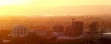
Manukau City was a large territorial authority in Auckland
, New Zealand
. The city was sometimes referred to as South Auckland
, but this term did not possess official recognition and did not encompass areas like East Auckland
, which was previously within the official boundaries of Manukau City. Manukau City was a relatively young city, both in terms of legal status and large-scale settlement – though with a current size of it was also the third-largest in New Zealand as well as the country's fastest-growing. The city existed from 1989 until 2010, when the entire Auckland Region
was amalgamated into a single city authority, Auckland Council
.
The name Manukau, from the Manukau Harbour
west of the city, is of Māori
origin, and means 'wading birds', although it has been suggested that the name of the harbour was also sometimes rendered as Mānuka, meaning a marker post with which an early chief is said to have claimed the area.
super city.
(itself an estuarial
arm of the Hauraki Gulf
) in the east and the Mangere Inlet (an arm of the Manukau Harbour
) to the west, the isthmus is only some 1500 metres across.
The area to the south of the isthmus contained the heart of Manukau, sprawled on either side of State Highways 1 and 20
, the latter of which approaches from the west after crossing Mangere Bridge
. The area known as Manukau Central is located close to the junction of these two highways, some 20 kilometres southeast of the centre of Auckland city.
Considerable rural and semi-rural land to the east of Manukau central were also within the city's limits. This extended towards the Hunua Ranges
close to the Firth of Thames
, and took in such communities as Clevedon
and Maraetai
.
Beyond Manukau City to the south was Papakura
and the Franklin District, which are less urban but still part of the Auckland Region and to some extent regarded as an integral part of Auckland's urban area.
Auckland Airport is located in Mangere, in the west of Manukau, close to the waters of the Manukau Harbour. Manukau City included the theme park Rainbow's End
, and one of the oldest shopping malls in the country, now called Westfield Manukau City
.
Like most of the rest of the region, Manukau is ethnically diverse, and is home to many peoples, especially Māori and members of Polynesia
n ethnicities, with a recent concentration of Asia
ns in and near Howick
. It is densely populated by New Zealand standards, despite having very few apartments.
As of the late 2000s, slightly less than 50% of the city's population identifies as European, with 17% as Māori, 27% as Pacific and 15% as Asian, with the balance made up of other groups.
was created.
.
Auckland
The Auckland metropolitan area , in the North Island of New Zealand, is the largest and most populous urban area in the country with residents, percent of the country's population. Auckland also has the largest Polynesian population of any city in the world...
, New Zealand
New Zealand
New Zealand is an island country in the south-western Pacific Ocean comprising two main landmasses and numerous smaller islands. The country is situated some east of Australia across the Tasman Sea, and roughly south of the Pacific island nations of New Caledonia, Fiji, and Tonga...
. The city was sometimes referred to as South Auckland
South Auckland
South Auckland is an imprecisely defined area of Auckland, New Zealand, often stereotyped as a socio-economically disadvantaged, and sometimes rough, urban area with a relatively large Polynesian and Māori population. The name South Auckland is not an official place name but is in common use by New...
, but this term did not possess official recognition and did not encompass areas like East Auckland
East Auckland
East Auckland is an area of Auckland, New Zealand characterised in the popular mind as a socio-economically mixed urban area with a relatively large multi-cultural population. The name East Auckland is not an official placename but is in popular use by New Zealanders. It is also used in the names...
, which was previously within the official boundaries of Manukau City. Manukau City was a relatively young city, both in terms of legal status and large-scale settlement – though with a current size of it was also the third-largest in New Zealand as well as the country's fastest-growing. The city existed from 1989 until 2010, when the entire Auckland Region
Auckland Region
The Auckland Region was one of the sixteen regions of New Zealand, named for the city of Auckland, the country's largest urban area. With one third of the nation's residents, it was by far the biggest population and economy of any region of New Zealand, but the second-smallest land area.On 1...
was amalgamated into a single city authority, Auckland Council
Auckland Council
The Auckland Council is the council for the Auckland Region in New Zealand. It began operating on 1 November 2010, combining the functions of the existing regional council and the region's seven previous city and district councils into one "super council" or "super city" governed by a mayor, 20...
.
The name Manukau, from the Manukau Harbour
Manukau Harbour
Manukau Harbour is the second largest natural harbour in New Zealand by area. It is located to the southwest of the Auckland isthmus, and is an arm of the Tasman Sea.-Geography:...
west of the city, is of Māori
Maori language
Māori or te reo Māori , commonly te reo , is the language of the indigenous population of New Zealand, the Māori. It has the status of an official language in New Zealand...
origin, and means 'wading birds', although it has been suggested that the name of the harbour was also sometimes rendered as Mānuka, meaning a marker post with which an early chief is said to have claimed the area.
History
Manukau City was formed by the amalgamation of Manukau County and Manurewa Borough in 1965. The city expanded in 1989 with New Zealand-wide reorganisation of local government to include Papatoetoe City and Howick Borough. However, some land was lost in the formation of Papakura District at the same time. On November 1, 2010 Manukau City was abolished and the governed area was amalgamated into the Manukau, Howick, Manurewa-Papakura, and Franklin wards of the new AucklandAuckland
The Auckland metropolitan area , in the North Island of New Zealand, is the largest and most populous urban area in the country with residents, percent of the country's population. Auckland also has the largest Polynesian population of any city in the world...
super city.
Geography
The Manukau City area was concentrated immediately to the south of the Otahuhu isthmus, the narrowest connection between Auckland City and the Northland region and the rest of the north island. At its narrowest, between the Otahuhu Creek arm of the Tamaki RiverTamaki River
The Tamaki River is, despite its name, mostly an estuarial arm and harbour of the Hauraki Gulf, within the city of Auckland in New Zealand. It extends south for 15 kilometres from its mouth between the Auckland suburb of Saint Heliers and the long thin peninsula of Bucklands Beach, which reaches...
(itself an estuarial
Estuary
An estuary is a partly enclosed coastal body of water with one or more rivers or streams flowing into it, and with a free connection to the open sea....
arm of the Hauraki Gulf
Hauraki Gulf
The Hauraki Gulf is a coastal feature of the North Island of New Zealand. It has a total area of 4000 km², and lies between the Auckland Region, the Hauraki Plains, the Coromandel Peninsula and Great Barrier Island...
) in the east and the Mangere Inlet (an arm of the Manukau Harbour
Manukau Harbour
Manukau Harbour is the second largest natural harbour in New Zealand by area. It is located to the southwest of the Auckland isthmus, and is an arm of the Tasman Sea.-Geography:...
) to the west, the isthmus is only some 1500 metres across.
The area to the south of the isthmus contained the heart of Manukau, sprawled on either side of State Highways 1 and 20
New Zealand State Highway network
The New Zealand State Highway network is the major national highway network in New Zealand. Just under 100 roads in both the North and South Islands are State Highways...
, the latter of which approaches from the west after crossing Mangere Bridge
Mangere Bridge
Mangere Bridge, officially also called the Manukau Harbour Crossing, is a motorway bridge over the Manukau Harbour in south-western Auckland, New Zealand, crossing between the suburb also known as Mangere Bridge and the suburb of Onehunga...
. The area known as Manukau Central is located close to the junction of these two highways, some 20 kilometres southeast of the centre of Auckland city.
Considerable rural and semi-rural land to the east of Manukau central were also within the city's limits. This extended towards the Hunua Ranges
Hunua Ranges
The Hunua Ranges form a block of hilly country to the southeast of Auckland in New Zealand's North Island. They cover some 250 square kilometres , containing 178 km² of parkland, and rise to 688 metres at Kohukohunui...
close to the Firth of Thames
Firth of Thames
The Firth of Thames is a large bay located in the north of the North Island of New Zealand. It is the firth of the rivers Waihou and Piako, the former of which was formerly named the Thames River, and the town of Thames lies on its southeastern coast....
, and took in such communities as Clevedon
Clevedon, New Zealand
Clevedon is a rural town in Auckland, New Zealand, located in the Franklin ward, one of the thirteen administrative divisions of Auckland city...
and Maraetai
Maraetai
Maraetai is one of the towns which make up Manukau city and is the easternmost suburb of greater Auckland in New Zealand.The closest town Beachlands lies approximately 4km to the West. Its name is Māori meaning "marae by the sea"...
.
Beyond Manukau City to the south was Papakura
Papakura
The Papakura District was the name of a local council territory in New Zealand's Auckland Region that existed from 1989 until 2010. The area made up the southernmost part of the Auckland metropolitan area....
and the Franklin District, which are less urban but still part of the Auckland Region and to some extent regarded as an integral part of Auckland's urban area.
Auckland Airport is located in Mangere, in the west of Manukau, close to the waters of the Manukau Harbour. Manukau City included the theme park Rainbow's End
Rainbow's End (Theme Park)
Rainbow's End is a 9.3 ha theme park in Auckland, New Zealand that opened in December, 1982. The park, wholly owned subsidiary of New Zealand Experience Ltd, is currently New Zealand's largest theme park...
, and one of the oldest shopping malls in the country, now called Westfield Manukau City
Westfield Manukau City
Westfield Manukau City is a major shopping centre located in South Auckland, New Zealand, near the intersection of the Auckland Southern Motorway and Southwest Motorway, south-southeast of the Auckland CBD....
.
Transport
In 2009, work started on a passenger branch railway junctioning with the North Island Main Trunk at Puhinui. The new branch will serve a university campus.Population
For some years before the 1989 reorganisation of local government, the then Manukau City had the highest population of any city or district in the country.Like most of the rest of the region, Manukau is ethnically diverse, and is home to many peoples, especially Māori and members of Polynesia
Polynesia
Polynesia is a subregion of Oceania, made up of over 1,000 islands scattered over the central and southern Pacific Ocean. The indigenous people who inhabit the islands of Polynesia are termed Polynesians and they share many similar traits including language, culture and beliefs...
n ethnicities, with a recent concentration of Asia
Asia
Asia is the world's largest and most populous continent, located primarily in the eastern and northern hemispheres. It covers 8.7% of the Earth's total surface area and with approximately 3.879 billion people, it hosts 60% of the world's current human population...
ns in and near Howick
Howick, New Zealand
Howick is an eastern suburb of Auckland, New Zealand, forming part of what is sometimes called East Auckland. Due to the relatively numerous remaining heritage buildings and other historical remnants from its early European settlement past, it has been called "perhaps Auckland's most historically...
. It is densely populated by New Zealand standards, despite having very few apartments.
As of the late 2000s, slightly less than 50% of the city's population identifies as European, with 17% as Māori, 27% as Pacific and 15% as Asian, with the balance made up of other groups.
Wards and suburbs
Manukau City was divided into 7 wards during its existence. The names of wards and lists of main suburbs/towns were:Botany-Clevedon Ward
| Howick Ward
Mangere Ward
| Manurewa Ward
| Otara Ward
Pakuranga Ward
Papatoetoe Ward
|
Prominent people
- Len BrownLen BrownLen Brown is the Mayor of Auckland in New Zealand and the head of the Auckland Council. He won the 2010 Auckland mayoral election on 9 October 2010 and was sworn in as Mayor of Auckland on 1 November 2010, being the first to hold that title for the amalgamated Auckland 'Super City'...
, former Mayor, now Auckland super city Mayor. - Jim AndertonJim AndertonJames Patrick Anderton, usually known as Jim Anderton , is the leader of the Progressive Party, a New Zealand political party. He has served in Parliament since 1984. He served as Deputy Prime Minister from 1999 to 2002 and is currently also the sitting Father of the House, the longest...
, former city councillor, who rose to be the country's Deputy Prime Minister. - Sir Barry CurtisBarry CurtisSir Barry Curtis was the Mayor of Manukau from 1983 until 2007. When he announced his intention to retire in 2007, he was New Zealand's longest serving mayor at that time.-Career:...
, former long-serving Mayor, from 1983 to 2007. - David LangeDavid LangeDavid Russell Lange, ONZ, CH , served as the 32nd Prime Minister of New Zealand from 1984 to 1989. He headed New Zealand's fourth Labour Government, one of the most reforming administrations in his country's history, but one which did not always conform to traditional expectations of a...
, former Prime Minister of New ZealandPrime Minister of New ZealandThe Prime Minister of New Zealand is New Zealand's head of government consequent on being the leader of the party or coalition with majority support in the Parliament of New Zealand...
and Member of Parliament for Mangere. - Award-winning rapper and former member of The DeceptikonzDeceptikonzThe Deceptikonz is a New Zealand Hip hop group formed in the South Auckland suburb of Manurewa in 1996 and consists of Savage, Devolo, Alphrisk and Mareko. Their debut album was Elimination released in 2002.- History :...
, SavageSavage (rapper)- Studio albums :-Singles:-Featured singles:- External links :*****...
.
Local government
The Manukau City Council was the elected local authority of the city from 1965 until November 2010 when the new Super City Council Auckland CouncilAuckland Council
The Auckland Council is the council for the Auckland Region in New Zealand. It began operating on 1 November 2010, combining the functions of the existing regional council and the region's seven previous city and district councils into one "super council" or "super city" governed by a mayor, 20...
was created.
Youth Council
Manukau City was an elected Youth Council which primarily acted as an advisory committee and advocate for youth in the city. It is unknown if this Youth Council will be continued with the new Auckland CouncilAuckland Council
The Auckland Council is the council for the Auckland Region in New Zealand. It began operating on 1 November 2010, combining the functions of the existing regional council and the region's seven previous city and district councils into one "super council" or "super city" governed by a mayor, 20...
.