
Northland Region
Encyclopedia
| Northland Regional Council | |
| Country: | New Zealand New Zealand New Zealand is an island country in the south-western Pacific Ocean comprising two main landmasses and numerous smaller islands. The country is situated some east of Australia across the Tasman Sea, and roughly south of the Pacific island nations of New Caledonia, Fiji, and Tonga... |
 |
|
| Regional Council | |
|---|---|
| Name: | Northland Regional Council |
| Chair: | Craig Brown |
| Deputy Chair: | John Bain John Bain John Bain is a retired Scottish-U.S. soccer midfielder who currently coaches youth soccer in the U.S. Bain began his professional career in England before moving to the United States in 1978. Over his twenty year playing career, Bain played for numerous leagues and teams, both indoors and out... |
| Population: | |
| Land Area: | 13,789 km² |
| Indigenous Iwi Iwi In New Zealand society, iwi form the largest everyday social units in Māori culture. The word iwi means "'peoples' or 'nations'. In "the work of European writers which treat iwi and hapū as parts of a hierarchical structure", it has been used to mean "tribe" , or confederation of tribes,... : |
Ngāi Takoto Ngai Takoto Ngāi Takoto is a Māori iwi from Northland, New Zealand. Ngāi Takoto trace their ancestry back to Tuwhakatere, and their arrival in New Zealand to the Kurahaupo canoe .... , Ngā Puhi, Ngāti Whātua Ngati Whatua Ngāti Whātua is a Māori iwi of New Zealand. It consists of four hapu : Te Uri-o-Hau, Te Roroa, Te Taoū, and Ngāti Whātua-o-Ōrākei.... , Ngāti Kahu Ngati Kahu Ngāti Kahu is a Māori iwi of Northland, New Zealand. Ngāti Kahu take their name from their founding ancestress, Kahutianui, and link their ancestry back to the waka Māmaru... , Ngāti Kurī Ngati Kuri Ngāti Kurī is a Māori iwi from Northland, New Zealand.Ngāti Kurī trace their ancestry to Pōhurihanga, the captain of the waka Kurahaupō. Kurī means dog in Māori.-External links:*... , Ngāti Wai Ngati Wai Ngāti Wai is a Māori iwi of the east coast of the Northland Region of New Zealand. Its historical area stretched from Cape Brett in the north to Takatu Point on Tawharanui Peninsula in the south and out to Great Barrier Island, the Poor Knights Islands and other offshore islands.Descendants of... , Te Aupōuri Te Aupouri Te Aupōuri is the northernmost Māori iwi , located north of Kaitaia, Northland, New Zealand, a region known as the Aupouri Peninsula.-The ancestral legend:... , Te Rarawa Te Rarawa Te Rarawa is a Māori iwi of Northland, New Zealand.-Prominent Te Rarawa:*Hector Busby, navigator and waka builder.*Whina Cooper, woman of mana, teacher, storekeeper and community leader.... Te Roroa Te Roroa Te Roroa is a Māori iwi from Northland, New Zealand.... |
| Website: | http://www.nrc.govt.nz |
| Cities and Towns | |
| Cities: | Whangarei Whangarei Whangarei, pronounced , is the northernmost city in New Zealand and the regional capital of Northland Region. Although commonly classified as a city, it is officially part of the Whangarei District, administered by the Whangarei District Council a local body created in 1989 to administer both the... |
| Towns: | Kaitaia Kaitaia Kaitaia is a town in the far north region of New Zealand, at the base of the Aupouri Peninsula which is about 160 km northwest of Whangarei. It is the last major settlement on the main road north to the capes and bays on the peninsula... , Kaeo Kaeo The township of Kaeo lies some 22 km northwest of Kerikeri in Northland, New Zealand. The town takes its name from the unique shellfish found in the nearby Whangaroa Harbour.... , Kawakawa Kawakawa, New Zealand Kawakawa is a small town in the Northland Region of northern New Zealand. It had a population of 1347 at the 2006 census, down from 1401 in 2001. Kawakawa developed as a service town when coal was found in the area in 1861, but there is no longer coal mining here... , Moerewa Moerewa Moerewa is a small town in the Northland Region of the North Island of New Zealand. It is unusual for its high proportion of Māori - over 80% of the population... , Kaikohe Kaikohe Kaikohe is the central service area for the Far North District of New Zealand, about 260 km from Auckland, situated on State Highway 12 at... , Ohaeawai Ohaeawai Ohaeawai is a small village at the junction of State Highway 1 and State Highway 12 in the Far North District of New Zealand, some 250 km from Auckland. Nearby is the site of the bloody Battle of Ohaeawai fought at Pene Taui's pā during the Flagstaff War in 1845... , Okaihau Okaihau Okaihau is a small town in the Northland Region of New Zealand's North Island, just north of Kaikohe. State Highway 1 passes through the town. The 2006 New Zealand Census of Population and Dwellings recorded Okaihau's population as 717, an increase of 30 people since the 2001 census.- Transport... , Kerikeri Kerikeri Kerikeri, the largest town in the Northland Region of New Zealand, is a popular tourist destination about three hours drive north of Auckland, and 80 km north of Whangarei... , Russell Russell, New Zealand Russell, formerly known as Kororareka, was the first permanent European settlement and sea port in New Zealand. It is situated in the Bay of Islands, in the far north of the North Island. As at the 2006 census it had a resident population of 816, an increase of 12 from 2001... , Paihia Paihia Paihia is the main tourist town in the Bay of Islands in the far north of the North Island of New Zealand. It is located close to the historic towns of Russell, and Kerikeri, 60 kilometres north of Whangarei. The origin of the name Paihia is obscure. One, possibily apocryphal, attribution is to... , Waitangi Waitangi, Northland For the main port and settlement at the Chatham Islands, see Waitangi, Chatham IslandsWaitangi is a township located in the Bay of Islands on the North Island of New Zealand. It is located close to the town of Paihia , 60 kilometres north of Whangarei... , Mangonui, Taipa, Donnelly's Crossing, Opononi Opononi Opononi is a settlement on the south shore of the Hokianga harbour in Northland Region, New Zealand. State Highway 12 runs through Opononi. Omapere lies to the south and Whirinaki lies to the north east.... , Omapere, Rawene Rawene Rawene is a town on the south side of the Hokianga harbour, in Northland, New Zealand. State Highway 12 passes to the south. The town lies at the apex of a peninsula... , Kohukohu Kohukohu, New Zealand Kohukohu is an historic village on the Hokianga Harbour in the far north of the North Island. It was one of the first European settlements in New Zealand.... , Ruakaka Ruakaka Ruakaka is a small township in the north of New Zealand approximately 30 kilometres south of Whangarei in the Bream Bay area. Originally a small beachside community, Ruakaka has seen development due to its proximity to the expansion of the country's only oil refinery at Marsden Point during the 1980s... , Waipu Waipu Waipu is a small town in Bream Bay, in the Northland Region of New Zealand, with a Scottish heritage. The population was 1,491 in the 2006 Census, an increase of 222 from 2001. A highlight of the town's calendar is the annual Highland Games held at New Year... , Kaiwaka Kaiwaka Kaiwaka "the little town of lights" is a settlement in Northland, New Zealand. The Kaiwaka River runs from the east through the area and joins with the Wairau River to form the Otamatea River, which drains into the Kaipara Harbour. State Highway 1 passes through Kaiwaka... , Mangawhai Mangawhai Mangawhai is a locality in Northland, New Zealand around the Mangawhai Harbour. The township of Mangawhai is at the south west extent of the harbour, and the township of Mangawhai Heads is 5 km north east... , Dargaville Dargaville Dargaville is a town in the North Island of New Zealand. It is situated on the bank of the Northern Wairoa River in the Northland region. The town is located 55 kilometres southwest of Whangarei.... , Ruawai Ruawai Ruawai is a small township located 30 km south of Dargaville in Northland, New Zealand. The population was 426 in the 2006 Census, a decrease of 30 from 2001.... , Maungaturoto Maungaturoto Maungaturoto is a small town in the Northland Region of New Zealand. The population was 837 in the 2006 Census, an increase of 87 from 2001. It is the second largest settlement in the Kaipara District.... , Paparoa Paparoa Paparoa is a settlement in Northland, New Zealand. The Paparoa Stream flows from the east, through the settlement, and into the Paparoa Creek to the south, which joins the Arapaoa River which is part of the Kaipara Harbour. State Highway 12 passes through Paparoa... . |
| Constituent Territorial Authorities | |
| Names: | Far North District Far North District The Far North District of New Zealand, as its name suggests, is the northernmost district within New Zealand, consisting of the northern tip of the North Island. The current mayor is Wayne Brown.-Geography:... , Kaipara District Kaipara District -Geography:Kaipara District is located in the low hills around the northern shores of the Kaipara Harbour, a large natural harbour open to the Tasman Sea... , Whangarei District Whangarei Whangarei, pronounced , is the northernmost city in New Zealand and the regional capital of Northland Region. Although commonly classified as a city, it is officially part of the Whangarei District, administered by the Whangarei District Council a local body created in 1989 to administer both the... |
| Websites: | http://www.fndc.govt.nz, http://www.kaipara.govt.nz, http://www.wdc.govt.nz, |
Regions of New Zealand
The region is the top tier of local government in New Zealand. There are 16 regions of New Zealand. Eleven are governed by an elected regional council, while five are governed by territorial authorities which also perform the functions of a regional council and thus are known as unitary authorities...
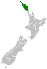
, is, as the name suggests, the northernmost of New Zealand
New Zealand
New Zealand is an island country in the south-western Pacific Ocean comprising two main landmasses and numerous smaller islands. The country is situated some east of Australia across the Tasman Sea, and roughly south of the Pacific island nations of New Caledonia, Fiji, and Tonga...
's administrative regions. The main centre is the city of Whangarei
Whangarei
Whangarei, pronounced , is the northernmost city in New Zealand and the regional capital of Northland Region. Although commonly classified as a city, it is officially part of the Whangarei District, administered by the Whangarei District Council a local body created in 1989 to administer both the...
.
Geography
Northland is located in what is often referred to by New Zealanders as the Far North, or, because of its mild climate, The Winterless North. It occupies the upper 80% of the 285 kilometre-long North Auckland PeninsulaNorth Auckland Peninsula
The North Auckland Peninsula, frequently referred to simply as the Northland Peninsula, is located in the far north of the North Island of New Zealand. The peninsula is easily confused with, though not the same as Northland Region, which occupies the top 80% of the peninsula...
, the southernmost part of which is in the Auckland Region
Auckland Region
The Auckland Region was one of the sixteen regions of New Zealand, named for the city of Auckland, the country's largest urban area. With one third of the nation's residents, it was by far the biggest population and economy of any region of New Zealand, but the second-smallest land area.On 1...
.
Stretching from a narrowing of the peninsula close to the town of Wellsford, Northland extends north to the tip of the North Auckland Peninsula, covering an area of 13,940 km², a little over five per cent of the country's total area. It is bounded to the west by the Tasman Sea
Tasman Sea
The Tasman Sea is the large body of water between Australia and New Zealand, approximately across. It extends 2,800 km from north to south. It is a south-western segment of the South Pacific Ocean. The sea was named after the Dutch explorer Abel Janszoon Tasman, the first recorded European...
, and to the east by the Pacific Ocean. The land is predominantly rolling hill country. Farming and forestry occupy over half of the land, and are two of the region's main industries.
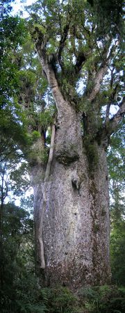
Although many of the region's kauri forests were felled during the 19th century, some areas still exist where this rare giant grows tall. New Zealand's largest tree, Tane Mahuta
Tane Mahuta
Tāne Mahuta is a giant kauri tree in the Waipoua Forest of Northland Region, New Zealand. Its age is unknown but is estimated to be between 1,250 and 2,500 years old. It is the largest kauri known to stand today...
, stands in the Waipoua Forest
Waipoua Forest
Waipoua Forest preserves some of the best examples of kauri forest remaining in New Zealand. It is notable for having two of the largest living kauri trees, Tane Mahuta and Te Matua Ngahere.The forest was declared a sanctuary in 1952....
south of the Hokianga
Hokianga
Hokianga is an area surrounding the Hokianga Harbour, also known as The Hokianga River, a long estuarine drowned valley on the west coast in the north of the North Island of New Zealand....
Harbour.
The western coast of the region is dominated by several long straight beaches, the most famous of which is the inaccurately named 88 kilometre-long stretch of Ninety Mile Beach
Ninety Mile Beach, New Zealand
Ninety Mile Beach is a beach located on the western coast of the far north of the North Island of New Zealand. It stretches from just west of Kaitaia towards Cape Reinga along the Aupouri Peninsula. It begins close to the headland of Reef Point, to the west of Ahipara Bay, sweeping briefly...
in the region's far north. Two large inlets are also located on this coast, the massive Kaipara Harbour
Kaipara Harbour
Kaipara Harbour is a large enclosed harbour estuary complex on the north western side of the North Island of New Zealand. The northern part of the harbour is administered by the Kaipara District and the southern part is administered by the Rodney District...
in the south, which Northland shares with the Auckland Region, and the convoluted inlets of the Hokianga Harbour.
The east coast is more rugged, and is dotted with bays and peninsulas. Several large natural harbours are found on this coast, from Parengarenga
Parengarenga Harbour
Parengarenga Harbour is a natural harbour close to the northernmost point on the North Island of New Zealand. Located at the northern end of the Aupouri Peninsula, it extends inland for over 10 kilometres, almost severing the northern tip of the island from the rest of the peninsula. The island's...
close to the region's northern tip, past the famous Bay of Islands
Bay of Islands
The Bay of Islands is an area in the Northland Region of the North Island of New Zealand. Located 60 km north-west of Whangarei, it is close to the northern tip of the country....
down to Whangarei Harbour, on the shores of which is situated the region's largest population centre. Numerous islands dot this coast, notably the Cavalli Islands
Cavalli Islands
The Cavalli Islands are a small group of islands in Whangaroa on Northland's East Coast in northern New Zealand. They lie to the east of Matauri Bay on the mainland....
, the Hen and Chickens Islands, Aorangaia Island
Aorangaia Island
Aorangaia Island is an island in the Northland Region of New Zealand, part of the Poor Knights Islands. It has a highest point of and is from the New Zealand mainland....
and the Poor Knights Islands
Poor Knights Islands
The Poor Knights Islands are a group of islands off the east coast of the Northland Region of the North Island of New Zealand. They are located to the northeast of Whangarei, and lie offshore half way between Bream Head and Cape Brett. Uninhabited since the 1820s, they are a nature reserve and...
.
The northernmost points of the North Island mainland lie at the top of Northland. These include several points often confused in the public mind as being the country's northernmost points: Cape Maria van Diemen
Cape Maria van Diemen
Cape Maria van Diemen is the westernmost point of the North Island of New Zealand. Being close to the northern tip of the Aupouri Peninsula, many people in New Zealand also incorrectly believe it to be the northernmost point...
, Spirits Bay
Spirits Bay
Spirits Bay is located at the northern end of the Aupouri Peninsula at the northern tip of New Zealand's North Island. At the western end of the bay is Cape Reinga, from which, according to Māori legend the spirits of the dead leave for their journey to the afterlife .The bay is 12 kilometres in...
, Cape Reinga
Cape Reinga
Cape Reinga is the northwesternmost tip of the Aupouri Peninsula, at the northern end of the North Island of New Zealand. Cape Reinga is located over 100 km north of the nearest small town of Kaitaia. State Highway 1 extends all the way to the Cape, but until 2010 was unsealed gravel road for the...
, and North Cape
North Cape, New Zealand
North Cape is located at the northern end of the North Auckland Peninsula in the North Island of New Zealand . It is the northeastern tip of the Aupouri Peninsula and lies 30 km east of Cape Reinga. The name is sometimes used to refer just to the cape which is known in Māori as Otou and which...
. The northernmost point of the North Island
North Island
The North Island is one of the two main islands of New Zealand, separated from the much less populous South Island by Cook Strait. The island is in area, making it the world's 14th-largest island...
is actually the Surville Cliffs
Surville Cliffs
The Surville Cliffs are the northernmost point of the mainland of New Zealand. They are situated on the North Cape of the North Island, 30 kilometres to the east of Cape Reinga , and three kilometres more northerly...
, close to North Cape, although the northernmost point of the country is further north in the Kermadec
Kermadec Islands
The Kermadec Islands are a subtropical island arc in the South Pacific Ocean northeast of New Zealand's North Island, and a similar distance southwest of Tonga...
chain of islands. Cape Reinga and Spirits Bay do, however, have a symbolic part to play as the end of the country. In Māori mythology
Maori mythology
Māori mythology and Māori traditions are the two major categories into which the legends of the Māori of New Zealand may usefully be divided...
, it is from here that the souls of the dead depart on their journey to the afterlife.
Climate
The region of Northland has a sub-tropical oceanic climate with warm humid summers and mild wet winters. Due to its latitude and low elevation, Northland has the country's highest average annual temperature. However, as with other parts of New Zealand, climate conditions are variable. In summer, temperatures range from 22 °C to 26 °C, occasionally rising above 30°C. In winter, maximum temperatures vary between 14 °C and 20 °C.Ground frosts are rare due to the region being encircled by the moderating Pacific and Tasman waters; however light frosts do occur infrequently around Dargaville in the lowlands. The hottest months are January and February due to the presence of an El Niño pressure system. In January 2009, excessive sunlight hours and below-average rainfall resulted in the region being declared a drought zone.
Typical annual rainfall for the region is 1500–2000 mm but varies at different altitudes. Northland has an average of 2000 sunshine hours annually. Winds are predominantly from the southwest. Occasionally in summer, the region experiences stormy conditions from former cyclones which generally become much weaker once they leave tropical latitudes.
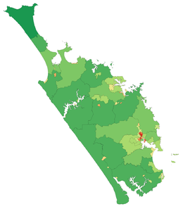
Administration
The seat of the Northland Regional Council is in Whangarei. There are three territorial authoritiesTerritorial authorities of New Zealand
Territorial authorities are the second tier of local government in New Zealand, below regional councils. There are 67 territorial authorities: 13 city councils, 53 district councils, and the Chatham Islands Council...
in the Northland region:
- Far North DistrictFar North DistrictThe Far North District of New Zealand, as its name suggests, is the northernmost district within New Zealand, consisting of the northern tip of the North Island. The current mayor is Wayne Brown.-Geography:...
Council, based in Kaikohe - Whangarei DistrictWhangarei DistrictThe Whangarei District is located in Northland, New Zealand. Whangarei is the principal town and the district seat. Other towns include Hukerenui, Hikurangi, Titoki, Ruakaka and Waipu...
Council - Kaipara DistrictKaipara District-Geography:Kaipara District is located in the low hills around the northern shores of the Kaipara Harbour, a large natural harbour open to the Tasman Sea...
Council, based in Dargaville
Population
Russell, New Zealand
Russell, formerly known as Kororareka, was the first permanent European settlement and sea port in New Zealand. It is situated in the Bay of Islands, in the far north of the North Island. As at the 2006 census it had a resident population of 816, an increase of 12 from 2001...
, Kaitaia
Kaitaia
Kaitaia is a town in the far north region of New Zealand, at the base of the Aupouri Peninsula which is about 160 km northwest of Whangarei. It is the last major settlement on the main road north to the capes and bays on the peninsula...
, Dargaville
Dargaville
Dargaville is a town in the North Island of New Zealand. It is situated on the bank of the Northern Wairoa River in the Northland region. The town is located 55 kilometres southwest of Whangarei....
, Kaikohe
Kaikohe
Kaikohe is the central service area for the Far North District of New Zealand, about 260 km from Auckland, situated on State Highway 12 at...
, Paihia
Paihia
Paihia is the main tourist town in the Bay of Islands in the far north of the North Island of New Zealand. It is located close to the historic towns of Russell, and Kerikeri, 60 kilometres north of Whangarei. The origin of the name Paihia is obscure. One, possibily apocryphal, attribution is to...
, Kerikeri
Kerikeri
Kerikeri, the largest town in the Northland Region of New Zealand, is a popular tourist destination about three hours drive north of Auckland, and 80 km north of Whangarei...
, Taipa-Mangonui
Taipa-Mangonui
Taipa-Mangonui is one name given to a string of small resort settlements in the far north of New Zealand's North Auckland Peninsula, close to the base of the Aupouri Peninsula...
, and Kawakawa
Kawakawa, New Zealand
Kawakawa is a small town in the Northland Region of northern New Zealand. It had a population of 1347 at the 2006 census, down from 1401 in 2001. Kawakawa developed as a service town when coal was found in the area in 1861, but there is no longer coal mining here...
. The population is largely concentrated along the region's east coast. During the five year period up to 2006, Northland recorded a population growth of 6.0 percent, slightly below the national average. Northland includes one of the fastest growing towns in New Zealand, Mangawhai
Mangawhai
Mangawhai is a locality in Northland, New Zealand around the Mangawhai Harbour. The township of Mangawhai is at the south west extent of the harbour, and the township of Mangawhai Heads is 5 km north east...
which is expanding rapidly due to residential and subsequent commercial development.
Māori refer to Northland — and by extension its Māori people — as Te Tai-tokerau (the northern tide) and Māori language
Maori language
Māori or te reo Māori , commonly te reo , is the language of the indigenous population of New Zealand, the Māori. It has the status of an official language in New Zealand...
and traditions are strong there. The Māori population in the region was 43,530 according to the 2006 Census, or 7.7 percent of the total Māori population. Half were under the age of 23.4 years. Major tribal groups include Ngāpuhi
Ngapuhi
Ngāpuhi is a Māori iwi located in the Northland region of New Zealand, and centred in the Hokianga, the Bay of Islands and Whāngārei.Ngāpuhi has the largest affiliation of any New Zealand iwi, with 122,214 people registered , and formed from 150 hapu, with 55 marae.-Foundations:The founding...
, Te Aupōuri
Te Aupouri
Te Aupōuri is the northernmost Māori iwi , located north of Kaitaia, Northland, New Zealand, a region known as the Aupouri Peninsula.-The ancestral legend:...
, Te Rarawa
Te Rarawa
Te Rarawa is a Māori iwi of Northland, New Zealand.-Prominent Te Rarawa:*Hector Busby, navigator and waka builder.*Whina Cooper, woman of mana, teacher, storekeeper and community leader....
, Ngāti Kahu
Ngati Kahu
Ngāti Kahu is a Māori iwi of Northland, New Zealand. Ngāti Kahu take their name from their founding ancestress, Kahutianui, and link their ancestry back to the waka Māmaru...
, Ngāti Kurī
Ngati Kuri
Ngāti Kurī is a Māori iwi from Northland, New Zealand.Ngāti Kurī trace their ancestry to Pōhurihanga, the captain of the waka Kurahaupō. Kurī means dog in Māori.-External links:*...
and Ngāti Whātua
Ngati Whatua
Ngāti Whātua is a Māori iwi of New Zealand. It consists of four hapu : Te Uri-o-Hau, Te Roroa, Te Taoū, and Ngāti Whātua-o-Ōrākei....
.
Over the last 10 years Northland's population has defied national (and worldwide) trends by becoming increasingly rural.
Approximately one third of the region's population are Māori, the majority of the remainder being of European lineage. Compared to the rest of the country Pacific Islanders are under-represented in Northland. Although most of the region's European population are of British stock (as is true with the rest of the country), certain other ethnicities have left their mark on the Northland racial mix. Of these the most influential have probably been the Dalmatia
Dalmatia
Dalmatia is a historical region on the eastern coast of the Adriatic Sea. It stretches from the island of Rab in the northwest to the Bay of Kotor in the southeast. The hinterland, the Dalmatian Zagora, ranges from fifty kilometers in width in the north to just a few kilometers in the south....
n community from the Dargaville area north, with a particularly strong heritage around Kaitaia.
History
Maui (Maori mythology)
In Māori mythology, Māui is a culture hero famous for his exploits and his trickery.-Māui's birth:The offspring of Tū increased and multiplied and did not know death until the generation of Māui-tikitiki . Māui is the son of Taranga, the wife of Makeatutara...
. For this reason, Northland sometimes goes by the nickname of "The tail of the fish", Te Hiku o Te Ika.
Northland iwi
Iwi
In New Zealand society, iwi form the largest everyday social units in Māori culture. The word iwi means "'peoples' or 'nations'. In "the work of European writers which treat iwi and hapū as parts of a hierarchical structure", it has been used to mean "tribe" , or confederation of tribes,...
claim that Kupe
Kupe
In the Māori mythology of some tribes, Kupe was involved in the Polynesian discovery of New Zealand.-Contention:There is contention concerning the status of Kupe. The contention turns on the authenticity of later versions of the legends, the so-called 'orthodox' versions closely associated with S....
made landfall at the Hokianga (although others claim this was at Taipa) in the northwest of Northland, and thus the region claims that it was the birthplace of New Zealand. Some of the oldest traces of Māori kainga (fishing villages), can be found here.
If the Māori regard the region as the legendary birthplace of the country, there can be no doubt that it was the European starting-point for the modern nation of New Zealand. Traders, whaler
Whaler
A whaler is a specialized ship, designed for whaling, the catching and/or processing of whales. The former included the whale catcher, a steam or diesel-driven vessel with a harpoon gun mounted at its bows. The latter included such vessels as the sail or steam-driven whaleship of the 16th to early...
s and seal
Pinniped
Pinnipeds or fin-footed mammals are a widely distributed and diverse group of semiaquatic marine mammals comprising the families Odobenidae , Otariidae , and Phocidae .-Overview: Pinnipeds are typically sleek-bodied and barrel-shaped...
ers were among the first arrivals, and the gum
Gum-digger
Kauri gum, a fossilized resin detracted from kauri trees, is used for chewing or tattooing, and often is made into jewellery. The gum comes from kauri trees found in Agathis australis forests. The trees once covered much of the New Zealand North Island, before Māori and European settlers caused...
and timber of the mighty kauri trees brought more colonisers.
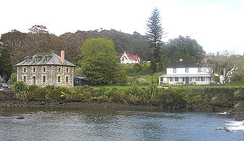
Kerikeri in the Bay of Islands can lay claim to being the first permanent European settlement in New Zealand, and contains many historic buildings, including the Stone Store
Stone Store
The Stone Store at Kerikeri in the Bay of Islands is New Zealand’s oldest surviving stone building.Part of the first Church Missionary Society station in New Zealand, the store was designed by John Hobbs to replace an earlier wooden store house. The Stone Store was erected between 1832 and 1836 by...
, New Zealand's oldest extant building.
The nearby settlement of Waitangi
Waitangi, Northland
For the main port and settlement at the Chatham Islands, see Waitangi, Chatham IslandsWaitangi is a township located in the Bay of Islands on the North Island of New Zealand. It is located close to the town of Paihia , 60 kilometres north of Whangarei...
was of even more significance, as the signing place of New Zealand's founding document, the Treaty of Waitangi
Treaty of Waitangi
The Treaty of Waitangi is a treaty first signed on 6 February 1840 by representatives of the British Crown and various Māori chiefs from the North Island of New Zealand....
between the Māori tribes and the British Crown, on 6 February 1840.
Economy
The sub-national GDP of the Northland region was estimated at US$3.243 billion in 2003, 2% of New Zealand's national GDP.The region's economy is based on agriculture (notably beef cattle), fishing, forestry
Forestry
Forestry is the interdisciplinary profession embracing the science, art, and craft of creating, managing, using, and conserving forests and associated resources in a sustainable manner to meet desired goals, needs, and values for human benefit. Forestry is practiced in plantations and natural stands...
, and horticulture
Horticulture
Horticulture is the industry and science of plant cultivation including the process of preparing soil for the planting of seeds, tubers, or cuttings. Horticulturists work and conduct research in the disciplines of plant propagation and cultivation, crop production, plant breeding and genetic...
. Citrus fruit makes up the majority of the latter industry, with lemons, oranges, and tamarillo
Tamarillo
Solanum betaceum is a small tree or shrub in the flowering plant family Solanaceae. It is best known as the species that bears the tamarillo, an egg-shaped edible fruit...
s all being produced. Avocado
Avocado
The avocado is a tree native to Central Mexico, classified in the flowering plant family Lauraceae along with cinnamon, camphor and bay laurel...
s are also widely grown, as well as kumara
Sweet potato
The sweet potato is a dicotyledonous plant that belongs to the family Convolvulaceae. Its large, starchy, sweet-tasting, tuberous roots are an important root vegetable. The young leaves and shoots are sometimes eaten as greens. Of the approximately 50 genera and more than 1,000 species of...
(especially in Ruawai part of the Kaipara
Kaipara Harbour
Kaipara Harbour is a large enclosed harbour estuary complex on the north western side of the North Island of New Zealand. The northern part of the harbour is administered by the Kaipara District and the southern part is administered by the Rodney District...
district). Olive
Olive
The olive , Olea europaea), is a species of a small tree in the family Oleaceae, native to the coastal areas of the eastern Mediterranean Basin as well as northern Iran at the south end of the Caspian Sea.Its fruit, also called the olive, is of major agricultural importance in the...
s are also being grown on the Aupouri Peninsula
Aupouri Peninsula
The Aupouri Peninsula is a tombolo at the northern tip of the North Island of New Zealand. It projects between the Tasman Sea to the west and the Pacific Ocean to the east...
.
Extensive forests are a feature of the Northland landscape. For this reason wood and paper manufacturing industries also make a large contribution to the region's economy.
Northland is a favourite tourist destination, especially to the Bay of Islands and the historic town of Kerikeri. Diving
Scuba diving
Scuba diving is a form of underwater diving in which a diver uses a scuba set to breathe underwater....
and fishing are also popular visitor activities, especially around the Bay of Islands and the Poor Knights island chain.
Northland is home to New Zealand's only oil refinery, at Marsden Point
Marsden Point
Marsden Point is a head of the Whangarei Harbour, near Whangarei, New Zealand, lying close to the northern tip of Bream Bay. It is also a major industrial area, containing Marsden Point Oil Refinery, the country's only such facility, and two large defunct power plant stations...
, close to Whangarei. New Zealand's natural fuel resources in Taranaki account for a little under half of the refinery's intake, with the rest coming predominantly from the Middle East. The nearby Marsden A thermal power station originally utilised heavy oil from the refinery for electricity production, but no longer does so.
External links
- The regional council's site
- Northland regional information web site.
- Northland in Te Ara the Encyclopedia of New Zealand
- This is the Place - Northland living history website
- The NZ Automobile Association's 101 Must-Do's for Northland Region