

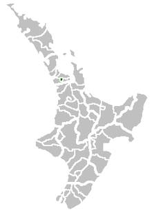
Papakura
Encyclopedia
| Papakura District | |
 |
|
| Country: | New Zealand New Zealand New Zealand is an island country in the south-western Pacific Ocean comprising two main landmasses and numerous smaller islands. The country is situated some east of Australia across the Tasman Sea, and roughly south of the Pacific island nations of New Caledonia, Fiji, and Tonga... |
| Main town: | Papakura Papakura The Papakura District was the name of a local council territory in New Zealand's Auckland Region that existed from 1989 until 2010. The area made up the southernmost part of the Auckland metropolitan area.... |
| Other towns: | Alfriston Alfriston Alfriston is a village and civil parish in the East Sussex district of Wealden, England. The village lies in the valley of the River Cuckmere, about four miles north-east of Seaford and south of the main A27 trunk road and part of the large area of Polegate... , Drury Drury Drury can refer to several things:*Drury, New Zealand*Drury, Flintshire, UK*Drury University, formerly Drury College, Springfield, Missouri*Drury Hotels operator of Drury Inns*Drury Lane, a famous street in the Westend of London... , Pahurehure Pahurehure Pahurehure is a suburb of Auckland, in northern New Zealand. Located on the south-eastern shores of the Manukau Harbour, under authority of the Papakura District Council. The suburb makes up the southernmost part of the Auckland metropolitan area.-History:... , Ardmore Ardmore Ardmore comes from the or the , meaning "great height", and may refer to:-Places:Canada:*Ardmore, Alberta*Ardmore Beach, a community in Tiny, OntarioIreland:*Ardmore, County Waterford, Republic of Ireland*Ardmore, County Londonderry, Northern Ireland... , Redhill, Takanini Takanini Takanini is a suburb of Auckland, and until 2010 is under authority of the Papakura District Council, in northern New Zealand. Located on the shores of the Pahurehure Inlet, it is located at , 28 kilometres southeast of the Auckland CBD.... |
| Population: | |
| Papakura (central) | 28,010 |
| Takanini | 10,870 |
| Territorial Authority | |
|---|---|
 |
|
| Name: | Papakura District |
| Mayor: | Len Brown Len Brown Len Brown is the Mayor of Auckland in New Zealand and the head of the Auckland Council. He won the 2010 Auckland mayoral election on 9 October 2010 and was sworn in as Mayor of Auckland on 1 November 2010, being the first to hold that title for the amalgamated Auckland 'Super City'... |
| Extent was: | Takanini to Drury; Pahurehure to Ardmore/Alfriston |
| Land Area was: | 123 km² |
| Website: | http://www.aucklandcouncil.govt.nz |
| See also: | Manukau City, Franklin Franklin District The territorial authority of Franklin District was abolished on 31 October 2010 and was divided between Auckland Council in the Auckland Region to the north and Waikato and Hauraki districts in the Waikato Region to the south and east. It was administered from the town of Pukekohe... |
| Council Contacts | |
| Postal Address | 35 Coles Cres, Private Bag 92300, Auckland 1142 |
| Internet Internet The Internet is a global system of interconnected computer networks that use the standard Internet protocol suite to serve billions of users worldwide... |
http://aucklandcouncil.govt.nz |
New Zealand
New Zealand is an island country in the south-western Pacific Ocean comprising two main landmasses and numerous smaller islands. The country is situated some east of Australia across the Tasman Sea, and roughly south of the Pacific island nations of New Caledonia, Fiji, and Tonga...
's Auckland Region
Auckland Region
The Auckland Region was one of the sixteen regions of New Zealand, named for the city of Auckland, the country's largest urban area. With one third of the nation's residents, it was by far the biggest population and economy of any region of New Zealand, but the second-smallest land area.On 1...
that existed from 1989 until 2010. The area made up the southernmost part of the Auckland
Auckland
The Auckland metropolitan area , in the North Island of New Zealand, is the largest and most populous urban area in the country with residents, percent of the country's population. Auckland also has the largest Polynesian population of any city in the world...
metropolitan area.
The area was originally a small independent city, until it became Papakura District in the 1989 reorganisation of New Zealand's local governments, and has now been overtaken by Auckland’s urban sprawl
Urban sprawl
Urban sprawl, also known as suburban sprawl, is a multifaceted concept, which includes the spreading outwards of a city and its suburbs to its outskirts to low-density and auto-dependent development on rural land, high segregation of uses Urban sprawl, also known as suburban sprawl, is a...
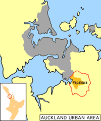
. The district is flanked by beaches on the Manukau Harbour
Manukau Harbour
Manukau Harbour is the second largest natural harbour in New Zealand by area. It is located to the southwest of the Auckland isthmus, and is an arm of the Tasman Sea.-Geography:...
to the west, Manukau City to the north and east, and the Franklin District
Franklin District
The territorial authority of Franklin District was abolished on 31 October 2010 and was divided between Auckland Council in the Auckland Region to the north and Waikato and Hauraki districts in the Waikato Region to the south and east. It was administered from the town of Pukekohe...
to the south.
Geography
In 2010, Papakura District boundaries covered 123 square kilometres and the centre of the district was located 32 km from downtown AucklandAuckland
The Auckland metropolitan area , in the North Island of New Zealand, is the largest and most populous urban area in the country with residents, percent of the country's population. Auckland also has the largest Polynesian population of any city in the world...
.
The geography of the district encompassed fertile plains, the inlets and foreshores of the Manukau Harbour, and the rolling foothills of the Hunua Range; a relatively narrow but strategically well positioned narrow span of land between the Hauraki Gulf and the Manukau Harbour. Much of the district – particularly in the west – is flat to rolling land. There is extensive peat soil in the Takanini area, which was once a vast wetland and peat bog. In the east, low-to-medium sized foothills lead out into the Hunua range.
The district was arranged into four wards during the existence of the Papakura District Council, now the entire area makes up a Papakura Local Board in the new Auckland city territory.
Ardmore Ward
| Pahurehure Ward
| Drury Ward
| Red Hill Ward
|
Keri Hill has pastoral lifestyle blocks overlooking Ardmore; Red Hill offered a strategic vantage point for the indigenous Maori people, but is now a popular suburb; Pahurehure has a harbourside setting on the eastern reaches of Manukau Harbour. Drury is the first genuine country town south of Auckland, and Takanini is Papakura's main industrial zone.
History
In the major reformation of local government in 1989, Papakura became a district. Prior to that time, a smaller area was known as Papakura CityPapakura City
-History:Papakura City was constituted as a city on 1 January 1975. It existed until the 1989 local government reforms, when "Papakura City" was subsumed by "Papakura District". In the 1989 reform, Drury and Karaka were added to Papakura from the Franklin area, and Ardmore, Alfriston and Takanini ...
, which was a small city of New Zealand, but the new area included parts of the surrounding rural countryside that had previously been part of Manukau City. After the major change “Papakura City” went to “Papakura District”, and instead of being an independent city, the area was amalgamated with Auckland
Auckland
The Auckland metropolitan area , in the North Island of New Zealand, is the largest and most populous urban area in the country with residents, percent of the country's population. Auckland also has the largest Polynesian population of any city in the world...
, including it into the Auckland Region
Auckland Region
The Auckland Region was one of the sixteen regions of New Zealand, named for the city of Auckland, the country's largest urban area. With one third of the nation's residents, it was by far the biggest population and economy of any region of New Zealand, but the second-smallest land area.On 1...
. The whole district counts as part of the Auckland urban area for statistical purposes, forming part of its southern boundary.
On 1 November 2010, Papakura District and the Papakura District Council was abolished and was included into a single Auckland city that is now governed by the Auckland Council
Auckland Council
The Auckland Council is the council for the Auckland Region in New Zealand. It began operating on 1 November 2010, combining the functions of the existing regional council and the region's seven previous city and district councils into one "super council" or "super city" governed by a mayor, 20...
. All council facilities and services were handed over to the new council.
People
Papakura District’s population was estimated to be growing at three times the rate of New Zealand as a whole and is predominantly European.It featured a mixture of ethnicities which is fairly typical of New Zealand, although over 26% of its residents are Māori and less than 63% are European. The city council is planning for Papakura's population to more than double by 2050.
Local Facilities
Government
In addition to the local council chambers, Papakura is served by a large Police Department; one of Auckland's busiest stations, a District Courthouse, and a WINZNew Zealand Ministry of Social Development
The Ministry of Social Development is a New Zealand government agency which has two main functions: providing social policy advice to the government, and providing social services. It is New Zealand’s largest government department employing people in over 200 locations around the country...
office. In 2004
Pitcairn sexual assault trial of 2004
On 30 September 2004, seven men living on Pitcairn Island , went on trial facing 55 charges relating to sexual offences. On 24 October, all but one of the defendants were found guilty on at least some of the charges they faced...
, the Papakura Courthouse acted as the Supreme Court
Supreme Court (Pitcairn)
The Supreme Court of the Pitcairn Islands was a special court set up to try the Pitcairn sexual assault trial of 2004. As the Pitcairns have a minimal population they have never had an extensive formal legal system...
for Pitcairn Island.
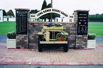
Armed Forces
Papakura once served a significant militaryNew Zealand Army
The New Zealand Army , is the land component of the New Zealand Defence Force and comprises around 4,500 Regular Force personnel, 2,000 Territorial Force personnel and 500 civilians. Formerly the New Zealand Military Forces, the current name was adopted around 1946...
population, but now only the SAS
Special Air Service of New Zealand
The New Zealand Special Air Service was formed on 7 July 1955 and is a special forces unit of the New Zealand Army modelled on the British Special Air Service . The New Zealand Government states that NZ SAS is the "premier combat unit of the New Zealand Defence Force". Its key roles are to...
special forces are based at Papakura. Nearby houses were originally Army Homes, but are now in private hands.
Transport
State Highway 1 (New Zealand)
State Highway 1 is the longest and most significant road in the New Zealand roading network, running the length of both main islands. It appears on road maps as SH 1 and on road signs as a white number 1 on a red shield, but it has the official designations SH 1N in the North Island, SH 1S in the...
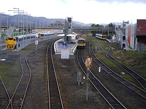
and the North Island Main Trunk Railway run through the Papakura District and a large airfield is located nearby at Ardmore. Train and bus services provide the bulk of public transport, with frequent trains on the Southern Line
Southern Line, Auckland
The Southern Line in Auckland, New Zealand is the name given to suburban train services that operate between Britomart and Pukekohe via Newmarket.-Routing:...
between Papakura
Papakura Train Station
Papakura Railway Station is on the Eastern and Southern Lines of the Auckland railway network.- Station Design :It features an island platform between the main lines, complete with original wooden station building and signal panel, and a suburban side platform to the west.- Services :This station...
and the CBD (Britomart
Britomart Transport Centre
Britomart Transport Centre is the CBD public transport hub of Auckland, New Zealand, and the northern terminus of the North Island Main Trunk line. It combines a bus interchange with a railway station in a former Edwardian post office, extended with expansive post-modernist architectural elements...
). Recent investment has focused on upgrading and refurbishing the region's trains and suburban railway stations, most recently with the opening of a modern station facility at the town centre. Papakura is the final stop for most southbound public transport in Auckland, and Papakura is the third busiest station on the rail network. Drawn by frequent services into and out of the city, rail commuters come from Papakura itself, Franklin County and the northern Waikato. Though the motorway and Great South Road flow relatively freely at peak times, road commuters are affected by the acute traffic congestion as they get closer to metropolitan Auckland.
Ardmore Airport
Ardmore Airport serves recreational aviators, private and commercial flights. It is the busiest airport in New Zealand based on aircraft movements, and is home to a wide range of innovative small to medium-sized aerospace businesses and popular among the non-commercial aviation sector.Recreation
Some notable sports facilities include an indoor-outdoor swimming pool, an international-quality athletics track, a sports stadium, and venues for rugby, netball, golf, tennis, badminton, soccer, and many other sports. The council also operates a library and a theatre. Papakura also has a number of skate parks, a skate bowl and an extensive BMX track that regularly hosts major cycling events.External links
- Interactive Maps: zoomin.co.nz District Plan Wises
- 2006 Census results (provisional) (ExcelMicrosoft ExcelMicrosoft Excel is a proprietary commercial spreadsheet application written and distributed by Microsoft for Microsoft Windows and Mac OS X. It features calculation, graphing tools, pivot tables, and a macro programming language called Visual Basic for Applications...
format) - Some histories of Papakura
- Breakwater against the Tide, by Elsdon Craig ISBN 0-908596-17-0 (definitive history of Papakura)
- Papakura Marae
- Rosehill College
- Papakura High School
- Papakura District Coat of Arms description of civic heraldry