

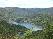
Hunua Ranges
Encyclopedia
Auckland
The Auckland metropolitan area , in the North Island of New Zealand, is the largest and most populous urban area in the country with residents, percent of the country's population. Auckland also has the largest Polynesian population of any city in the world...
in New Zealand
New Zealand
New Zealand is an island country in the south-western Pacific Ocean comprising two main landmasses and numerous smaller islands. The country is situated some east of Australia across the Tasman Sea, and roughly south of the Pacific island nations of New Caledonia, Fiji, and Tonga...
's North Island
North Island
The North Island is one of the two main islands of New Zealand, separated from the much less populous South Island by Cook Strait. The island is in area, making it the world's 14th-largest island...
. They cover some 250 square kilometres (100 sq mi), containing 178 km² of parkland, and rise to 688 metres (2255 ft) at Kohukohunui. Auckland gets much of its water from reservoirs within the Hunua Ranges.
The ranges are located approximately 50 kilometres (30 mi) southeast of Auckland, above the western shore of the Firth of Thames
Firth of Thames
The Firth of Thames is a large bay located in the north of the North Island of New Zealand. It is the firth of the rivers Waihou and Piako, the former of which was formerly named the Thames River, and the town of Thames lies on its southeastern coast....
. They are sparsely populated, and mostly lie within the boundaries of the Waharau and Hunua Ranges Regional Parks.
Maori made some use of the ranges and early European visitors found areas of clearing that had been used as gardens. Ngāi Tai
Ngai Tai
Ngāi Tai is a Māori tribal group in the area around Tōrere in the East Coast area of the North Island, New Zealand, and also at Clevedon near Auckland....
are tangata whenua. Some Maori archaeological sites are known. The main part of the ranges was subject to confiscation after the New Zealand Wars.
Early European use of the ranges was for timber extraction and for farming but low soil fertility limited success. There has been some mining of Manganese in the past. Gold prospecting for quartz reefs has never found payable reefs.
From the 1920s onwards the land was progressively bought by Auckland City Council utilising funds from its water supply operation. Development of the water supplies commenced in the late 1940s. The bulk water supply operation and the land passed to the newly formed Auckland Regional Authority in 1964. The Authority completed the water supply development and continued the exotic afforestation on some of the north and western catchment land, started by the City Council. Its Water Department administered the land. The water operation was corporatised as Watercare Services Ltd in 1992, but all the land remained with the Auckland Regional Council (as it was by then). Watercare took ownership of the water related assets and took a long term lease from the Auckland Regional Council of the reservoir areas and the operational areas. The exotic forestry land was also leased to another party. The catchment land became regional park land.
In November 2010, the southernmost part of the Hunua Ranges were transferred to Waikato Region. This determines the local government administrative boundaries, but the ownership of the former Auckland Regional Council park land went to the Auckland Council and that of the water assets is unchanged with Watercare Services.