
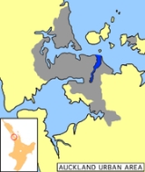
Tamaki River
Encyclopedia
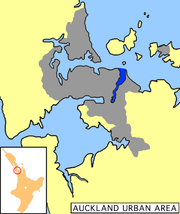
Estuary
An estuary is a partly enclosed coastal body of water with one or more rivers or streams flowing into it, and with a free connection to the open sea....
arm and harbour of the Hauraki Gulf
Hauraki Gulf
The Hauraki Gulf is a coastal feature of the North Island of New Zealand. It has a total area of 4000 km², and lies between the Auckland Region, the Hauraki Plains, the Coromandel Peninsula and Great Barrier Island...
, within the city of Auckland
Auckland
The Auckland metropolitan area , in the North Island of New Zealand, is the largest and most populous urban area in the country with residents, percent of the country's population. Auckland also has the largest Polynesian population of any city in the world...
in New Zealand
New Zealand
New Zealand is an island country in the south-western Pacific Ocean comprising two main landmasses and numerous smaller islands. The country is situated some east of Australia across the Tasman Sea, and roughly south of the Pacific island nations of New Caledonia, Fiji, and Tonga...
. It extends south for 15 kilometres from its mouth between the Auckland suburb of Saint Heliers and the long thin peninsula
Peninsula
A peninsula is a piece of land that is bordered by water on three sides but connected to mainland. In many Germanic and Celtic languages and also in Baltic, Slavic and Hungarian, peninsulas are called "half-islands"....
of Bucklands Beach, which reaches its end at Musick Point
Musick Point
Musick Point is the headland of the peninsula that forms the eastern shore of the Tamaki River in Bucklands Beach, a suburb of Manukau City in New Zealand. In 1942 Musick Point was named after Ed Musick, a famous aviator,who visited NZ in 1937., although the headland is also known as Te Waiarohia,...
.
The inlet extends past the suburbs of Glendowie
Glendowie, New Zealand
Glendowie is a suburb in Auckland, New Zealand. Glendowie is under the local governance of the Auckland City Council.According to the 2001 census, Glendowie has a population of 3,825.-Location:...
, Glen Innes
Glen Innes, New Zealand
Glen Innes is a suburb located in Auckland, New Zealand. It is located nine kilometres to the east of the city centre, close to the waters of the Tamaki River.The main streets in Glen Innes are Line Road and Apirana Avenue, which meet at a roundabout...
, Tamaki
Tamaki, New Zealand
Tamaki is a small suburb of the city of Auckland, in the North Island of New Zealand. It is located in the east of the city, 11 kilometres from the city centre, by the banks of the estuarial Tamaki River, which is a southern arm of the Hauraki Gulf...
, Panmure
Panmure, New Zealand
Panmure is a south-eastern suburb of Auckland City, in the North Island of New Zealand. It is located 11 kilometres southeast of the city centre, close to the western banks of the Tamaki River and the northern shore of the Panmure Basin...
, and Otahuhu to the west, and Bucklands Beach, Halfmoon Bay, Farm Cove, Sunnyhills
Sunnyhills, New Zealand
- to the north-east - to the east - to the south - to the south-west - to the west - to the north-west Farm Cove Half Moon Bay Highland Park Pakuranga Heights...
and Pakuranga
Pakuranga
Pakuranga is an eastern suburb of Auckland, in northern New Zealand. Pakuranga covers a series of low ridges and previously swampy flats, now drained, that lie between the Pakuranga Creek and Tamaki River, two estuarial arms of the Hauraki Gulf...
to the east.
It has several smaller "tributary arms" which extend from it: the Pakuranga Creek and Otara Creek in the east, and the Otahuhu Creek and Panmure Basin
Panmure Basin
The Panmure Basin, also sometimes known as the Panmure Lagoon, is a tidal estuary within a volcanic crater or maar in New Zealand's Auckland Volcanic Field. It is located to the south of Panmure town centre....
in the west. The Otahuhu Creek forms the eastern shore of the narrowest point on the Auckland isthmus
Isthmus
An isthmus is a narrow strip of land connecting two larger land areas usually with waterforms on either side.Canals are often built through isthmuses where they may be particularly advantageous to create a shortcut for marine transportation...
: here it is less than two kilometres to the waters of the Manukau Harbour
Manukau Harbour
Manukau Harbour is the second largest natural harbour in New Zealand by area. It is located to the southwest of the Auckland isthmus, and is an arm of the Tasman Sea.-Geography:...
, an arm of the Tasman Sea
Tasman Sea
The Tasman Sea is the large body of water between Australia and New Zealand, approximately across. It extends 2,800 km from north to south. It is a south-western segment of the South Pacific Ocean. The sea was named after the Dutch explorer Abel Janszoon Tasman, the first recorded European...
.
History
Portage Road is the location of one of the 2 historical portages overland routes between the two coasts. Here the Maori would beach their waka (canoe)Waka (canoe)
Waka are Māori watercraft, usually canoes ranging in size from small, unornamented canoes used for fishing and river travel, to large decorated war canoes up to long...
s and drag them overland to the other coast, thus avoiding having to paddle around North Cape
North Cape, New Zealand
North Cape is located at the northern end of the North Auckland Peninsula in the North Island of New Zealand . It is the northeastern tip of the Aupouri Peninsula and lies 30 km east of Cape Reinga. The name is sometimes used to refer just to the cape which is known in Māori as Otou and which...
.The second portage was named Karetu and went between the extreme north east corner of the Manakau harbour to a bay close to the site of the newest bridge across the Tamaki about 1km south of the Panmure basin. These portages made the area of immense strategic importance in both pre-European times and during the early years of European occupation.
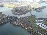
In 1865, the estuary was first crossed by a steel swing bridge, located at Panmure
Panmure
Panmure may refer to:Places*Panmure, New Zealand, a suburb of Auckland*Panmure , a former New Zealand Parliamentary electorate*Panmure, Victoria, Australia*Panmure Island, Prince Edward Island, Canada...
, to improve connection between Auckland and Howick
Howick, New Zealand
Howick is an eastern suburb of Auckland, New Zealand, forming part of what is sometimes called East Auckland. Due to the relatively numerous remaining heritage buildings and other historical remnants from its early European settlement past, it has been called "perhaps Auckland's most historically...
.The location is 20m to the left of the left hand (Panmure) bridge shown in the photo. Stones and steel had been imported from Australia, possibly reflecting the still very basic nature of industrial construction in the young colony. In the 1890s the mouth of the river was used as a safe anchorage for ships carrying explosives. One such ship caught fire and exploded with loss of life. After this the explosives buoy was moved into a more open area east of Browns Island (Motukorea)
Browns Island, Auckland
Browns Island or Motukorea is a small New Zealand island, in the Hauraki Gulf north of Musick Point, one of the best preserved volcanoes in the Auckland Volcanic Field. The age of eruption is currently unknown. Due to centuries of cultivation, little native bush remains except on the north-eastern...
, where it is still located.
Transport
Due to its extent north-south and its position between Auckland CityAuckland City
Auckland City was the city and local authority covering the Auckland isthmus and most of the islands of the Hauraki Gulf, in the North Island of New Zealand. On 1 November 2010 it was amalgamated into the wider Auckland Region under the authority of the new Auckland Council...
and its eastern neighbour Manukau City, the River is a natural barrier to traffic, especially as only three bridges cross it, all heavily trafficked and increasingly incapable of taking the peak hour flows. The AMETI scheme has the resolution of this bottle-neck as one of its goals.
The Tamaki River also has a marina / ferry wharf at Half Moon Bay
Half Moon Bay, Auckland
Half Moon Bay is a coastal suburb located immediately south of Bucklands Beach in Manukau City, Auckland, New Zealand.It is well known for the Half Moon Bay Marina, home to over 500 boats...
, from where commuter ferries depart for the Auckland CBD
Auckland CBD
The Auckland CBD is the geographical and economic heart of the Auckland metropolitan area. Bounded by several major motorways and by the harbour coastline in the north, it is surrounded further out by mostly suburban areas...
and car/passenger ferries for Waiheke Island
Waiheke Island
Waiheke Island is an island in the Hauraki Gulf of New Zealand, located about from Auckland.The island is the second-largest in the Hauraki Gulf after Great Barrier Island. It is the most populated, with nearly 8,000 permanent residents plus another estimated 3,400 who have second or holiday homes...
. Many yachts are also moored in its relatively well protected interiors. The river channel is marked with large green buoys. Deep draught vessels should stay close to the buoys as the channel, although averaging 20 m deep is very narrow in many places. Near the large Point England sand spit there are numerous mudflats which are barely covered at high tide. The speed limit in the river is 10 km/h (5.1 kn). Rocks at the Western mouth of the river at St Heliers are marked by a distinctive barber's pole
Barber's pole
A barber's pole is a type of sign used by barbers to signify the place or shop where they perform their craft. The trade sign is, by a tradition dating back to the Middle Ages, a staff or pole with a helix of colored stripes...
. Vessels of more than 4 m draught should not attempt the opening between Musick Point and Browns Island. The channel in this area is marked by port and starboard markers about 20m apart. It is 0.5 km North West of Musick Point. Large mussel beds extend out 200 m from Browns Island into the river.