

List of bridges on the National Register of Historic Places in Oregon
Encyclopedia
This is a list of bridge
s and tunnel
s on the National Register of Historic Places
in the U.S. state
of Oregon
.
Gray shading indicates that a structure has been removed from the Register. Often the road listed in the "location" column now parallels the bridge on a new one, and the old bridge is closed to traffic.
Bridge
A bridge is a structure built to span physical obstacles such as a body of water, valley, or road, for the purpose of providing passage over the obstacle...
s and tunnel
Tunnel
A tunnel is an underground passageway, completely enclosed except for openings for egress, commonly at each end.A tunnel may be for foot or vehicular road traffic, for rail traffic, or for a canal. Some tunnels are aqueducts to supply water for consumption or for hydroelectric stations or are sewers...
s on the National Register of Historic Places
National Register of Historic Places
The National Register of Historic Places is the United States government's official list of districts, sites, buildings, structures, and objects deemed worthy of preservation...
in the U.S. state
U.S. state
A U.S. state is any one of the 50 federated states of the United States of America that share sovereignty with the federal government. Because of this shared sovereignty, an American is a citizen both of the federal entity and of his or her state of domicile. Four states use the official title of...
of Oregon
Oregon
Oregon is a state in the Pacific Northwest region of the United States. It is located on the Pacific coast, with Washington to the north, California to the south, Nevada on the southeast and Idaho to the east. The Columbia and Snake rivers delineate much of Oregon's northern and eastern...
.
Gray shading indicates that a structure has been removed from the Register. Often the road listed in the "location" column now parallels the bridge on a new one, and the old bridge is closed to traffic.
| Name | Image | Built | Listed | Location | County | Type |
|---|---|---|---|---|---|---|
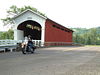
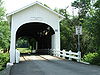
| Belknap Bridge Belknap Bridge The Belknap Bridge crosses the McKenzie River near the unincorporated community of Rainbow in Lane County, Oregon, United States. It is approximately three miles west of the town of McKenzie Bridge which is named after the bridge. It is the fourth covered bridge built on the site. The bridge is... |
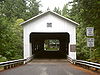 |
1966 | 1979-11-29 | McKenzie River McKenzie River The McKenzie River is a tributary of the Willamette River in western Oregon in the United States. It drains part of the Cascade Range east of Eugene and flows into the southernmost end of the Willamette Valley. It is named for Donald MacKenzie, a Scottish Canadian fur trader... , Rainbow Rainbow, Oregon Rainbow is an unincorporated community in Lane County, Oregon, United States. It lies off Oregon Route 126, northeast of Eugene. Rainbow's elevation is . A post office was established on July 1, 1924, and closed August 31, 1937. The post office got its name from the rainbow trout that swim in the... 44.168°N 122.228°W |
Lane Lane County, Oregon -National protected areas:*Oregon Islands National Wildlife Refuge *Siuslaw National Forest *Umpqua National Forest *Willamette National Forest -Government:... |
Covered Covered bridge A covered bridge is a bridge with enclosed sides and a roof, often accommodating only a single lane of traffic. Most covered bridges are wooden; some newer ones are concrete or metal with glass sides... Howe truss |
| Big Creek Bridge No. 01180 | 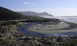 |
1931 | 2005-08-05 | US 101 over Big Creek, north of Florence Florence, Oregon Florence is a city in Lane County, Oregon, United States. As of the 2010 census, the city had a total population of 8,466.-History:The Florence area was originally inhabited by the Siuslaw tribe of Native Americans. Some state that the city was named for state senator A. B... 44.174°N 124.115°W |
Lane Lane County, Oregon -National protected areas:*Oregon Islands National Wildlife Refuge *Siuslaw National Forest *Umpqua National Forest *Willamette National Forest -Government:... |
|
| Cape Creek Bridge No. 01113 | 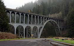 |
1932 | 2005-08-05 | US 101 over Cape Creek, north of Florence Florence, Oregon Florence is a city in Lane County, Oregon, United States. As of the 2010 census, the city had a total population of 8,466.-History:The Florence area was originally inhabited by the Siuslaw tribe of Native Americans. Some state that the city was named for state senator A. B... 44.133°N 124.122°W |
Lane Lane County, Oregon -National protected areas:*Oregon Islands National Wildlife Refuge *Siuslaw National Forest *Umpqua National Forest *Willamette National Forest -Government:... |
|
| Chambers Bridge | 1936 | 1979-11-29 | Tyler Avenue over Coast Fork Willamette River Coast Fork Willamette River The Coast Fork Willamette River is one of several forks that unite to form the Willamette River in western Oregon in the United States. It is about long, draining an area of the mountains at the south end of the Willamette Valley south of Eugene.-Course:... , Cottage Grove Cottage Grove, Oregon Cottage Grove is a city in Lane County, Oregon, United States. It received its name from its first postmaster, G. C. Pierce, in September 1861. Pierce's home at the time was in an oak grove. The population was 9,686 at the 2010 census.-History:... 43.789°N 123.070°W |
Lane Lane County, Oregon -National protected areas:*Oregon Islands National Wildlife Refuge *Siuslaw National Forest *Umpqua National Forest *Willamette National Forest -Government:... |
Covered Covered bridge A covered bridge is a bridge with enclosed sides and a roof, often accommodating only a single lane of traffic. Most covered bridges are wooden; some newer ones are concrete or metal with glass sides... Howe truss |
|
| Chitwood Bridge | 1979-11-29 | Chitwood Road over Yaquina River Yaquina River The Yaquina River is a river, approximately 50 mi long, on the Pacific coast of Oregon in the United States. It drains an area of the Central Oregon Coast Range west of the Willamette Valley near Newport.... , Chitwood Chitwood, Oregon Chitwood is an unincorporated community in Lincoln County, Oregon, United States. Chitwood lies on U.S. Route 20 between Toledo to the west and Eddyville to the east.... 44.654°N 123.818°W |
Lincoln Lincoln County, Oregon -National protected areas:*Oregon Islands National Wildlife Refuge *Siletz Bay National Wildlife Refuge*Siuslaw National Forest -Demographics:... |
Covered Covered bridge A covered bridge is a bridge with enclosed sides and a roof, often accommodating only a single lane of traffic. Most covered bridges are wooden; some newer ones are concrete or metal with glass sides... Howe truss |
||
| Coos Bay Bridge No. 01823 | 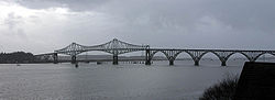 |
1936 | 2005-08-05 | US 101 over Coos Bay Coos Bay Coos Bay is an S-shaped inlet where the Coos River enters the Pacific Ocean, approximately 10 miles long and two miles wide, on the Pacific Ocean coast of southwestern Oregon in the United States. The estuary is situated south of the Salmon River. The city of Coos Bay, once named Marshfield, was... , North Bend North Bend, Oregon North Bend is a city in Coos County, Oregon, in the United States with a population of 9,695 as of the 2010 census. North Bend is surrounded on three sides by Coos Bay, an S-shaped water inlet and estuary where the Coos River enters Coos Bay on the Pacific Ocean, and borders the city of Coos Bay,... 43.426°N 124.222°W |
Coos Coos County, Oregon -National protected areas:*Bandon Marsh National Wildlife Refuge*Oregon Islands National Wildlife Refuge *Siskiyou National Forest *Siuslaw National Forest - Incorporated cities:- Unincorporated communities and CDPs:-See also:... |
|
| Coyote Creek Bridge Coyote Creek Bridge The Coyote Creek Bridge, located near Crow, Oregon, is listed on the National Register of Historic Places.... |
1922 | 1979-11-29 | Coyote Creek Road over Coyote Creek, south of Crow Crow, Oregon Crow is an unincorporated community in Lane County, Oregon, United States.-History:According to Oregon Geographic Names, a post office was established in 1874 and named after community founders James Andrew Jackson Crow and Helen Fisk Crow, pioneers who came to Oregon by wagon train... 43.970°N 123.319°W |
Lane Lane County, Oregon -National protected areas:*Oregon Islands National Wildlife Refuge *Siuslaw National Forest *Umpqua National Forest *Willamette National Forest -Government:... |
Covered Covered bridge A covered bridge is a bridge with enclosed sides and a roof, often accommodating only a single lane of traffic. Most covered bridges are wooden; some newer ones are concrete or metal with glass sides... Howe truss |
|
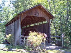
| Crabtree Creek-Hoffman Covered Bridge |  |
1936 | 1987-02-17 | Hungry Hill Road over Crabtree Creek, north of Crabtree Crabtree, Oregon Crabtree is an unincorporated community in Linn County, Oregon, United States. Although it is unincorporated, it has a post office with a ZIP code of 97335. Crabtree lies off of Oregon Route 226 10 miles east of Albany.... 44.653°N 122.890°W |
Linn Linn County, Oregon Linn County is a county located in the U.S. state of Oregon. It is named in honor of Lewis F. Linn, a U.S. Senator from Missouri who advocated the American occupation of the Oregon Country. By the 2010 US census the population of Linn county was 116,672 showing a 13.2% growth since the 2000 census... |
Covered Covered bridge A covered bridge is a bridge with enclosed sides and a roof, often accommodating only a single lane of traffic. Most covered bridges are wooden; some newer ones are concrete or metal with glass sides... Howe truss |
| Crawfordsville Bridge | 1932 | 1979-11-29 | OR 228 over Calapooia River Calapooia River The Calapooia River is a tributary of the Willamette River in the U.S. state of Oregon.The Calapooia runs through Crawfordsville and Brownsville in the Willamette Valley. The river converges with the Willamette near Albany. It was named for the Kalapuya , a tribe of Native Americans.-References:... , Crawfordsville Crawfordsville, Oregon Crawfordsville is an unincorporated community in Linn County, Oregon, United States. Although it is unincorporated, it has a post office with a ZIP code of 97336. Crawfordsville lies on Oregon Route 228 between Brownsville to the west and Sweet Home to the east.... 44.358°N 122.860°W |
Linn Linn County, Oregon Linn County is a county located in the U.S. state of Oregon. It is named in honor of Lewis F. Linn, a U.S. Senator from Missouri who advocated the American occupation of the Oregon Country. By the 2010 US census the population of Linn county was 116,672 showing a 13.2% growth since the 2000 census... |
Covered Covered bridge A covered bridge is a bridge with enclosed sides and a roof, often accommodating only a single lane of traffic. Most covered bridges are wooden; some newer ones are concrete or metal with glass sides... Howe truss |
|
| Currin Bridge Currin Bridge The Currin Bridge is a Howe truss covered bridge near Cottage Grove, Oregon, United States. It crosses the Row River.The Currin Bridge was built in 1925 to replace another bridge built in 1883. The lowest bid received by Lane County for construction of the bridge was $6,250, so the county decided... |
 |
1925 | 1979-11-29 | Layng Road over Row River Row River The Row River is a river, approximately long, in Lane County, Oregon, United States. It rises in the Cascade Range and flows into the Coast Fork Willamette River near Cottage Grove. The stream was originally known as the "East Fork Coast Fork", but was later renamed after a dispute between... , east of Cottage Grove Cottage Grove, Oregon Cottage Grove is a city in Lane County, Oregon, United States. It received its name from its first postmaster, G. C. Pierce, in September 1861. Pierce's home at the time was in an oak grove. The population was 9,686 at the 2010 census.-History:... 43.793°N 122.996°W |
Lane Lane County, Oregon -National protected areas:*Oregon Islands National Wildlife Refuge *Siuslaw National Forest *Umpqua National Forest *Willamette National Forest -Government:... |
Covered Covered bridge A covered bridge is a bridge with enclosed sides and a roof, often accommodating only a single lane of traffic. Most covered bridges are wooden; some newer ones are concrete or metal with glass sides... Howe truss |
| Deadwood Creek Bridge Deadwood Creek Bridge The Deadwood Creek Bridge, located near Swisshome, Oregon, is listed on the National Register of Historic Places.... |
1932 | 1979-11-29 | Deadwood Loop over Deadwood Creek, north of Deadwood Deadwood, Oregon Deadwood is an unincorporated community in Lane County, Oregon, United States. It is located on Oregon Route 36, in the Oregon Coast Range.Deadwood was named after Deadwood Creek, a tributary of the Siuslaw River. Deadwood Creek was so-named because of the dead timber snags next to its banks, which... 44.144°N 123.720°W |
Lane Lane County, Oregon -National protected areas:*Oregon Islands National Wildlife Refuge *Siuslaw National Forest *Umpqua National Forest *Willamette National Forest -Government:... |
Covered Covered bridge A covered bridge is a bridge with enclosed sides and a roof, often accommodating only a single lane of traffic. Most covered bridges are wooden; some newer ones are concrete or metal with glass sides... Howe truss |
|
| Depoe Bay Bridge No. 01388 | 1927 | 2005-08-05 | US 101 over Depoe Bay, Depoe Bay Depoe Bay, Oregon Depoe Bay is a city in Lincoln County, Oregon, United States, located on U.S. Route 101 next to the Pacific Ocean. The population was 1,174 at the 2000 census, with an unofficial estimated population of 1,355 in 2007... 44.810°N 124.062°W |
Lincoln Lincoln County, Oregon -National protected areas:*Oregon Islands National Wildlife Refuge *Siletz Bay National Wildlife Refuge*Siuslaw National Forest -Demographics:... |
||
| Dorena Bridge Dorena Bridge The Dorena Bridge, located near Dorena, Oregon, is listed on the National Register of Historic Places.-See also:* List of Oregon covered bridges* List of bridges on the National Register of Historic Places in Oregon... |
1949 | 1979-11-29 | Shoreview Drive over Row River Row River The Row River is a river, approximately long, in Lane County, Oregon, United States. It rises in the Cascade Range and flows into the Coast Fork Willamette River near Cottage Grove. The stream was originally known as the "East Fork Coast Fork", but was later renamed after a dispute between... , north of Dorena Dorena, Oregon Dorena is an unincorporated community in Lane County, Oregon, United States. It is located southeast of Cottage Grove on the Row River, a tributary of the Coast Fork Willamette River.-History:... 43.737°N 122.884°W |
Lane Lane County, Oregon -National protected areas:*Oregon Islands National Wildlife Refuge *Siuslaw National Forest *Umpqua National Forest *Willamette National Forest -Government:... |
Covered Covered bridge A covered bridge is a bridge with enclosed sides and a roof, often accommodating only a single lane of traffic. Most covered bridges are wooden; some newer ones are concrete or metal with glass sides... Howe truss |
|
| Ernest Bridge Ernest Bridge The Ernest Bridge, located near Marcola, Oregon, is listed on the National Register of Historic Places.... |
1938 | 1979-11-29 | Paschelke Road over Mohawk River Mohawk River (Oregon) The Mohawk River is the largest tributary of the McKenzie River, approximately long, in west central Oregon in the United States. It drains part of the foothills of the Cascade Range on the southeast end of the Willamette Valley northeast of Springfield.... , north of Marcola Marcola, Oregon Marcola is an unincorporated community in Lane County, Oregon, United States, northeast of Springfield on the Mohawk River.-History:The post office at this location was established in 1876 and originally called "Isabel" for early settler Isabel Applegate. About 1900, a railroad was built through... 44.201°N 122.836°W |
Lane Lane County, Oregon -National protected areas:*Oregon Islands National Wildlife Refuge *Siuslaw National Forest *Umpqua National Forest *Willamette National Forest -Government:... |
Covered Covered bridge A covered bridge is a bridge with enclosed sides and a roof, often accommodating only a single lane of traffic. Most covered bridges are wooden; some newer ones are concrete or metal with glass sides... Howe truss |
|
| Fisher School Bridge | 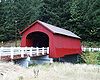 |
1925 | 1979-11-29 | East Crab Creek Road over Five Rivers Five Rivers (Oregon) Five Rivers is a stream in the U.S. state of Oregon, located in Benton County.... , Fisher Fisher, Oregon Fisher is an unincorporated community in rural Lincoln County, Oregon, United States. Fisher lies along Five Rivers Road. The closest town is Tidewater.... 44.292°N 123.841°W |
Lincoln Lincoln County, Oregon -National protected areas:*Oregon Islands National Wildlife Refuge *Siletz Bay National Wildlife Refuge*Siuslaw National Forest -Demographics:... |
Covered Covered bridge A covered bridge is a bridge with enclosed sides and a roof, often accommodating only a single lane of traffic. Most covered bridges are wooden; some newer ones are concrete or metal with glass sides... Howe truss |
| Gallon House Bridge Gallon House Bridge Gallon House Bridge is a wooden covered bridge spanning Abiqua Creek in rural Marion County, Oregon, United States built in 1916. The 84 foot long bridge derived its name during prohibition when it was a meeting place for bootleggers and moonshiners. The bridge was swept off its footings in the... |
 |
1916 | 1979-11-29 | Gallon House Road over Abiqua Creek Abiqua Creek Abiqua Creek is a tributary of the Pudding River in the U.S. state of Oregon. The creek originates near Lookout Mountain in the foothills of the Cascade Range in the northwestern part of the state. It flows northwest for about to its confluence with the Pudding, about west of Silverton, in the... , northwest of Silverton Silverton, Oregon Silverton is a city in Marion County, Oregon, United States, along the 45th parallel. The population was 7,414 at the 2000 census. It is part of the Salem Metropolitan Statistical Area.-Geography:... 45.032°N 122.798°W |
Marion Marion County, Oregon Marion County is a county located in the U.S. state of Oregon. It was originally named the Champooick District, after Champoeg, a meeting place on the Willamette River. On September 3, 1849, the territorial legislature renamed it in honor of Francis Marion, a Continental Army general of the... |
Covered Covered bridge A covered bridge is a bridge with enclosed sides and a roof, often accommodating only a single lane of traffic. Most covered bridges are wooden; some newer ones are concrete or metal with glass sides... Howe truss |
| Goodpasture Bridge Goodpasture Bridge The Goodpasture Bridge spans the McKenzie River near the community of Vida in Lane County, Oregon, United States. It is the second longest covered bridge and one of the most photographed covered bridges in the state... |
 |
1938 | 1979-11-29 | Goodpasture Road over McKenzie River McKenzie River The McKenzie River is a tributary of the Willamette River in western Oregon in the United States. It drains part of the Cascade Range east of Eugene and flows into the southernmost end of the Willamette Valley. It is named for Donald MacKenzie, a Scottish Canadian fur trader... , west of Vida Vida, Oregon Vida is an unincorporated community in Lane County, Oregon, United States. It is located on Oregon Route 126 and the McKenzie River.Vida was originally named "Gate Creek", but this caused confusion with a community of "Gates Creek" in Washington County, so the name of the postmaster's daughter was... 44.148°N 122.588°W |
Lane Lane County, Oregon -National protected areas:*Oregon Islands National Wildlife Refuge *Siuslaw National Forest *Umpqua National Forest *Willamette National Forest -Government:... |
Covered Covered bridge A covered bridge is a bridge with enclosed sides and a roof, often accommodating only a single lane of traffic. Most covered bridges are wooden; some newer ones are concrete or metal with glass sides... Howe truss |
| Grave Creek Bridge | 1920 | 1979-11-29 | Sunny Valley Loop over Grave Creek, Sunny Valley Sunny Valley, Oregon Sunny Valley is an unincorporated community in Josephine County, Oregon, United States. Sunny Valley lies at just east of exit number 71, the Sunny Valley exit, on Interstate 5.... 42.636°N 123.378°W |
Josephine Josephine County, Oregon Josephine County is a county located in the U.S. state of Oregon. According to Oregon Geographic Names, the county is probably named after a stream in the area called Josephine Creek, which in turn is probably named after Virginia Josephine Rollins Ort. In 2010, its population was 82,713... |
Covered Covered bridge A covered bridge is a bridge with enclosed sides and a roof, often accommodating only a single lane of traffic. Most covered bridges are wooden; some newer ones are concrete or metal with glass sides... Howe truss |
|
| Hannah Bridge |  |
1936 | 1979-11-29 | Camp Morrison Drive over Thomas Creek Thomas Creek (Oregon) Oregon has at least 19 features named Thomas Creek:... , east of Scio Scio, Oregon Scio is a city in Linn County, Oregon, United States. The population was 838 at the 2010 census.-Geography:According to the United States Census Bureau, the city has a total area of , all of it land.-History:... 44.712°N 122.719°W |
Linn Linn County, Oregon Linn County is a county located in the U.S. state of Oregon. It is named in honor of Lewis F. Linn, a U.S. Senator from Missouri who advocated the American occupation of the Oregon Country. By the 2010 US census the population of Linn county was 116,672 showing a 13.2% growth since the 2000 census... |
Covered Covered bridge A covered bridge is a bridge with enclosed sides and a roof, often accommodating only a single lane of traffic. Most covered bridges are wooden; some newer ones are concrete or metal with glass sides... Howe truss |
| Harris Bridge Harris Bridge (Wren, Oregon) The Harris Bridge, located near Wren, Oregon, is a bridge listed on the National Register of Historic Places.... |
 |
1936 | 1979-11-29 | Harris Road over Marys River Marys River Marys River is a tributary of the Willamette River in the U.S. state of Oregon. From its source at the confluence of its east and west forks near Summit, it flows generally southeast from the Central Oregon Coast Range to Corvallis.-Name:... , Harris Harris, Oregon Harris is an unincorporated community in Benton County, Oregon, United States. Harris lies on U.S. Route 20 just south of its interchange with Oregon Route 223 in Wren.... 44.580°N 123.460°W |
Benton Benton County, Oregon -National protected areas:*Siuslaw National Forest *William L. Finley National Wildlife Refuge-Demographics:As of the census of 2000, there were 78,153 people, 30,145 households, and 18,237 families residing in the county. The population density was 116 people per square mile . There were 31,980... |
Covered Covered bridge A covered bridge is a bridge with enclosed sides and a roof, often accommodating only a single lane of traffic. Most covered bridges are wooden; some newer ones are concrete or metal with glass sides... Howe truss |
| Hayden Bridge Hayden Bridge Hayden Bridge, a Howe truss structure, spans the Alsea River about west of Alsea, Oregon, United States. Constructed in 1918, the span is one of only seven remaining covered bridges in Oregon that were built before 1920. Similar spans such as the Mill Creek Bridge crossed the Alsea or one of its... |
 |
1918 | 1979-11-29 | Hayden Road over Alsea River Alsea River The Alsea River flows from Alsea, an unincorporated community in the coastal mountains of the U.S. state of Oregon, to the Pacific Ocean near the city of Waldport. It begins at the confluence of the North Fork Alsea River and the South Fork Alsea River and ends in Alsea Bay, a wide estuary at... , west of Alsea Alsea, Oregon Alsea is an unincorporated community in Benton County, Oregon, United States. It is located on Oregon Route 34 and the Alsea River.As of the 2010 Census, the population was 164.... 44.383°N 123.631°W |
Benton Benton County, Oregon -National protected areas:*Siuslaw National Forest *William L. Finley National Wildlife Refuge-Demographics:As of the census of 2000, there were 78,153 people, 30,145 households, and 18,237 families residing in the county. The population density was 116 people per square mile . There were 31,980... |
Covered Covered bridge A covered bridge is a bridge with enclosed sides and a roof, often accommodating only a single lane of traffic. Most covered bridges are wooden; some newer ones are concrete or metal with glass sides... Howe truss |
| Lake Creek Bridge Lake Creek Bridge The Lake Creek Bridge, located near Greenleaf, Oregon, is listed on the National Register of Historic Places.... |
1928 | 1979-11-29 | Chickahominy Road over Lake Creek, south of Greenleaf Greenleaf, Oregon Greenleaf is an unincorporated community in Lane County, Oregon, United States and has a post office with a ZIP code of 97430. Greenleaf lies on Oregon Route 36 east of Deadwood and west of Triangle Lake.-History:... 44.104°N 123.674°W |
Lane Lane County, Oregon -National protected areas:*Oregon Islands National Wildlife Refuge *Siuslaw National Forest *Umpqua National Forest *Willamette National Forest -Government:... |
Covered Covered bridge A covered bridge is a bridge with enclosed sides and a roof, often accommodating only a single lane of traffic. Most covered bridges are wooden; some newer ones are concrete or metal with glass sides... Howe truss |
|
| Larwood Bridge | 1939 | 1979-11-29 | Fish Hatchery Drive over Crabtree Creek, Larwood 44.630°N 122.741°W |
Linn Linn County, Oregon Linn County is a county located in the U.S. state of Oregon. It is named in honor of Lewis F. Linn, a U.S. Senator from Missouri who advocated the American occupation of the Oregon Country. By the 2010 US census the population of Linn county was 116,672 showing a 13.2% growth since the 2000 census... |
Covered Covered bridge A covered bridge is a bridge with enclosed sides and a roof, often accommodating only a single lane of traffic. Most covered bridges are wooden; some newer ones are concrete or metal with glass sides... Howe truss |
|
| Longview Bridge |  |
1929, 1930 | 1982-07-16 | Columbia River Columbia River The Columbia River is the largest river in the Pacific Northwest region of North America. The river rises in the Rocky Mountains of British Columbia, Canada, flows northwest and then south into the U.S. state of Washington, then turns west to form most of the border between Washington and the state... , Rainier Rainier, Oregon Rainier is a city in Columbia County, Oregon, United States. The population was 1,687 at the 2000 census. Rainier is located on the south bank of the Columbia River across from Kelso and Longview, Washington-History:... 46.105°N 122.962°W |
Columbia Columbia County, Oregon Columbia County is a county located in the U.S. state of Oregon. It was named for the Columbia River, which forms its eastern and northern borders. As of 2010, its population was 49,351. The county seat is St. Helens.-Economy:... |
Cantilever bridge Cantilever bridge A cantilever bridge is a bridge built using cantilevers, structures that project horizontally into space, supported on only one end. For small footbridges, the cantilevers may be simple beams; however, large cantilever bridges designed to handle road or rail traffic use trusses built from... |
| Lost Creek Bridge Lost Creek Bridge The Lost Creek Bridge is a wooden covered bridge located near Lake Creek, Oregon, United States, about 15 miles ENE of Medford. The bridge is about 11.89 meters long, making it the shortest covered bridge in Oregon.... |
 |
1919 | 1979-11-29 | Lost Creek Road over Lost Creek, southeast of Lake Creek Lake Creek, Oregon Lake Creek is an unincorporated community located approximately 20 miles east of Medford, in Jackson County, Oregon, United States. The community takes its name from an important local stream.The shortest covered bridge in Oregon is located near Lake Creek... 42.380°N 122.580°W |
Jackson Jackson County, Oregon -National protected areas:* Cascade–Siskiyou National Monument* Crater Lake National Park * Klamath National Forest * Rogue River-Siskiyou National Forest * Umpqua National Forest -Demographics:... |
Covered Covered bridge A covered bridge is a bridge with enclosed sides and a roof, often accommodating only a single lane of traffic. Most covered bridges are wooden; some newer ones are concrete or metal with glass sides... modified queenpost truss |
| Lowell Bridge Lowell Bridge Lowell Bridge is a covered bridge in Lowell, Oregon, United States. The current bridge was built in 1907.- History :Before the Lowell Bridge was constructed, pioneer Amos Hyland settled on the Middle Fork Willamette River in 1874, and established the town of Lowell, which he named after his... |
1945, 1947, 1953 | 1979-11-29 | Pioneer Street over Dexter Lake Dexter Lake Dexter Reservoir is a reservoir in Lane County, Oregon, United States.It is on the Middle Fork Willamette River, and downriver from Lookout Point Lake. The communities of Dexter and Lowell are located next to the lake. Oregon Route 58 travels alongside its southern shore.... , south of Lowell Lowell, Oregon Lowell is a city in Lane County, Oregon, in the United States. As of the 2010 census, the city population was 1,045.-Geography:According to the United States Census Bureau, the city has a total area of , of which is land and , or 25.0%, is water.... 43.909°N 122.779°W |
Lane Lane County, Oregon -National protected areas:*Oregon Islands National Wildlife Refuge *Siuslaw National Forest *Umpqua National Forest *Willamette National Forest -Government:... |
Covered Covered bridge A covered bridge is a bridge with enclosed sides and a roof, often accommodating only a single lane of traffic. Most covered bridges are wooden; some newer ones are concrete or metal with glass sides... Howe truss |
|
| McKee Bridge | 1917 | 1979-11-29 | McKee Branch Road over Applegate River Applegate River The Applegate River is a long tributary of the Rogue River in the U.S. state of Oregon. It drains approximately . Rising in northern California, it soon crosses the border and flows northeast then northwest to meet the Rogue about west of Grants Pass... , south of Ruch Ruch, Oregon Ruch is an unincorporated community in Jackson County, Oregon, United States. It is located on Oregon Route 238, southeast of Grants Pass.Ruch was named for Casper M. Ruch, who bought a tract of land where the community now stands in 1896. He built a blacksmith shop, a store and a house... 42.126°N 123.073°W |
Jackson Jackson County, Oregon -National protected areas:* Cascade–Siskiyou National Monument* Crater Lake National Park * Klamath National Forest * Rogue River-Siskiyou National Forest * Umpqua National Forest -Demographics:... |
Covered Covered bridge A covered bridge is a bridge with enclosed sides and a roof, often accommodating only a single lane of traffic. Most covered bridges are wooden; some newer ones are concrete or metal with glass sides... Howe truss |
|
| Milo Academy Bridge | 1962 | 1979-11-29 | Milo Drive over South Umpqua River South Umpqua River The South Umpqua River is a tributary of the Umpqua River, approximately long, in southwestern Oregon in the United States. It drains part of the Cascade Range east of Roseburg... , Milo Milo, Oregon Milo is an unincorporated community in Douglas County, Oregon, United States, about 17 miles east of Canyonville on the South Umpqua River.Milo post office was established in 1923; Cora E. Buker was the first postmaster. It was named for Milo, Maine, the hometown of Amos O. Buker, who was the... 42.935°N 123.039°W |
Douglas Douglas County, Oregon -National protected areas:* Crater Lake National Park * Rogue River-Siskiyou National Forest * Siuslaw National Forest * Umpqua National Forest * Willamette National Forest -Adjacent counties:* Lane County, Oregon -... |
Covered Covered bridge A covered bridge is a bridge with enclosed sides and a roof, often accommodating only a single lane of traffic. Most covered bridges are wooden; some newer ones are concrete or metal with glass sides... |
|
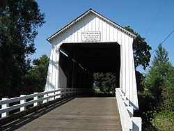
| Mosby Creek Bridge Mosby Creek Bridge The Mosby Creek Bridge, also called the Layng Bridge, is a covered bridge that uses the Howe truss. It is located near Cottage Grove, Oregon. The bridge was constructed in 1920, making it the oldest covered bridge in Lane County, Oregon.... |
1920 | 1979-11-29 | Layng Road over Mosby Creek, east of Cottage Grove Cottage Grove, Oregon Cottage Grove is a city in Lane County, Oregon, United States. It received its name from its first postmaster, G. C. Pierce, in September 1861. Pierce's home at the time was in an oak grove. The population was 9,686 at the 2010 census.-History:... 43.778°N 123.005°W |
Lane Lane County, Oregon -National protected areas:*Oregon Islands National Wildlife Refuge *Siuslaw National Forest *Umpqua National Forest *Willamette National Forest -Government:... |
Covered Covered bridge A covered bridge is a bridge with enclosed sides and a roof, often accommodating only a single lane of traffic. Most covered bridges are wooden; some newer ones are concrete or metal with glass sides... Howe truss |
|
| North Fork of the Yachats Bridge | 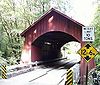 |
1938 | 1979-11-29 | North Yachats River Road over North Fork Yachats River, east of Yachats Yachats, Oregon Yachats is a small coastal city in Lincoln County, Oregon, United States. According to Oregon Geographic Names, the name comes from the Siletz language, and means "dark water at the foot of the mountain". There is a range of differing etymologies, however. William Bright says the name comes from... 44.310°N 123.97°W |
Lincoln Lincoln County, Oregon -National protected areas:*Oregon Islands National Wildlife Refuge *Siletz Bay National Wildlife Refuge*Siuslaw National Forest -Demographics:... |
Covered Covered bridge A covered bridge is a bridge with enclosed sides and a roof, often accommodating only a single lane of traffic. Most covered bridges are wooden; some newer ones are concrete or metal with glass sides... queenpost truss |
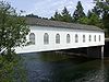
| Office Bridge Office Bridge The Office Bridge is a covered bridge in Westfir, Lane County, Oregon, U.S. crossing the North Fork Middle Fork Willamette River at the south end of the Aufderheide National Scenic Byway and edge of the Willamette National Forest... |
 |
1944 | 1979-11-29 | Westoak Road over North Fork Middle Fork Willamette River, Westfir Westfir, Oregon Westfir is a city in Lane County, Oregon, United States. The population was 253 at the 2010 census. It is located about south of Eugene and about west of Oakridge in the Willamette National Forest.-History:... 43.758°N 122.496°W |
Lane Lane County, Oregon -National protected areas:*Oregon Islands National Wildlife Refuge *Siuslaw National Forest *Umpqua National Forest *Willamette National Forest -Government:... |
Covered Covered bridge A covered bridge is a bridge with enclosed sides and a roof, often accommodating only a single lane of traffic. Most covered bridges are wooden; some newer ones are concrete or metal with glass sides... Howe truss |
| Oregon Railway and Navigation Company Bridge | 1887, 1907 | 1980-03-13 | McKenzie River McKenzie River The McKenzie River is a tributary of the Willamette River in western Oregon in the United States. It drains part of the Cascade Range east of Eugene and flows into the southernmost end of the Willamette Valley. It is named for Donald MacKenzie, a Scottish Canadian fur trader... south of Coburg Coburg, Oregon Coburg is a city in Lane County, Oregon, United States, north of Eugene. The city's population as of the 2010 census was 1,035.- History :... 44.113°N 123.047°W |
Lane Lane County, Oregon -National protected areas:*Oregon Islands National Wildlife Refuge *Siuslaw National Forest *Umpqua National Forest *Willamette National Forest -Government:... |
||
| Parvin Bridge Parvin Bridge The Parvin Bridge is a covered bridge located in Lane County, Oregon, U.S. near Dexter. It was built in 1921 as a single-lane bridge across Lost Creek, a tributary of the Middle Fork Willamette River.... |
1921 | 1979-11-29 | Anthony Creek Road over Lost Creek, south of Dexter Dexter, Oregon Dexter is an unincorporated community in Lane County, Oregon, United States. It is located near Dexter Lake , a reservoir of the Willamette River along Oregon Route 58.... 43.899°N 122.823°W |
Lane Lane County, Oregon -National protected areas:*Oregon Islands National Wildlife Refuge *Siuslaw National Forest *Umpqua National Forest *Willamette National Forest -Government:... |
Covered Covered bridge A covered bridge is a bridge with enclosed sides and a roof, often accommodating only a single lane of traffic. Most covered bridges are wooden; some newer ones are concrete or metal with glass sides... Howe truss |
|
| Pengra Bridge Pengra Bridge The Pengra Bridge, located near Jasper, Oregon, is listed on the National Register of Historic Places.... |
1938 | 1979-11-29 | Place Road over Fall Creek, southeast of Jasper Jasper, Oregon Jasper is an unincorporated community in Lane County, Oregon, United States. It is located southeast of Springfield on Oregon Route 222, at the confluence of Hills Creek and the Middle Fork Willamette River.... 43.966°N 122.845°W |
Lane Lane County, Oregon -National protected areas:*Oregon Islands National Wildlife Refuge *Siuslaw National Forest *Umpqua National Forest *Willamette National Forest -Government:... |
Covered Covered bridge A covered bridge is a bridge with enclosed sides and a roof, often accommodating only a single lane of traffic. Most covered bridges are wooden; some newer ones are concrete or metal with glass sides... Howe truss |
|
| Portland and Southwestern Railroad Tunnel Portland and Southwestern Railroad Tunnel The Portland and Southwestern Railroad Tunnel near Scappoose, Oregon, United States, was driven by the Portland and Southwestern Railroad, whose chief business was logging. Unusually for a logging railroad, the Portland and Southwestern built tunnels. In order to reach the far side of the Nehalem... |
 |
1910, 1920, 1921 | 1981-08-17 | Proposed Crown Zellerbach Trail, west of Chapman 45.833°N 123.047°W |
Columbia Columbia County, Oregon Columbia County is a county located in the U.S. state of Oregon. It was named for the Columbia River, which forms its eastern and northern borders. As of 2010, its population was 49,351. The county seat is St. Helens.-Economy:... |
|
| Portland–Vancouver Highway Bridge (Interstate Bridge) Interstate Bridge The Interstate Bridge is a pair of nearly identical steel vertical-lift, through-truss bridges that carry Interstate 5 traffic over the Columbia River between Vancouver, Washington, and Portland, Oregon, in the United States... |
1915–1917 | 1982-07-16 | I-5 over Columbia River Columbia River The Columbia River is the largest river in the Pacific Northwest region of North America. The river rises in the Rocky Mountains of British Columbia, Canada, flows northwest and then south into the U.S. state of Washington, then turns west to form most of the border between Washington and the state... , north of Portland Portland, Oregon Portland is a city located in the Pacific Northwest, near the confluence of the Willamette and Columbia rivers in the U.S. state of Oregon. As of the 2010 Census, it had a population of 583,776, making it the 29th most populous city in the United States... 45.620°N 122.674°W |
Multnomah Multnomah County, Oregon Multnomah County is one of 36 counties in the U.S. state of Oregon. Though smallest in area, it is the most populous as its county seat, Portland, is the state's largest city... |
Steel truss Truss bridge A truss bridge is a bridge composed of connected elements which may be stressed from tension, compression, or sometimes both in response to dynamic loads. Truss bridges are one of the oldest types of modern bridges... with vertical-lift section |
|
| Ritner Creek Bridge | 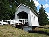 |
1927, 1976 | 1979-11-29 | OR 223 over Ritner Creek, Ritner 44.728°N 123.442°W |
Polk Polk County, Oregon Polk County is a county located in the U.S. state of Oregon. The county is named for James Knox Polk, the 11th president of the United States. In 2010, its population was 75,403. The seat of the county is Dallas.... |
Covered Covered bridge A covered bridge is a bridge with enclosed sides and a roof, often accommodating only a single lane of traffic. Most covered bridges are wooden; some newer ones are concrete or metal with glass sides... Howe truss |
| Rock O' the Range Bridge Rock O' the Range Bridge The Rock O' The Range Bridge, sometimes called the Swalley Canal Bridge, is a bridge located north of Bend, Oregon, U.S., on a street adjacent to U.S. Route 97. It is the only covered span in the state of Oregon on the east side of the Cascade Range... |
1963 | 1979-11-29 | Bowery Lane over Swalley Canal, north of Bend Bend, Oregon Bend is a city in and the county seat of Deschutes County, Oregon, United States, and the principal city of the Bend, Oregon Metropolitan Statistical Area. Bend is Central Oregon's largest city, and, despite its modest size, is the de facto metropolis of the region, owing to the low population... 44.122°N 121.287°W |
Deschutes Deschutes County, Oregon -National protected areas:* Deschutes National Forest * Newberry National Volcanic Monument-Demographics:As of the census of 2000, there were 115,367 people, 45,595 households, and 31,962 families residing in the county. The population density was 38 people per square mile . There were 54,583... |
Covered Covered bridge A covered bridge is a bridge with enclosed sides and a roof, often accommodating only a single lane of traffic. Most covered bridges are wooden; some newer ones are concrete or metal with glass sides... king post truss |
|
| Rocky Creek Bridge No. 01089 |  |
1927 | 2005-08-05 | Otter Crest Loop Road (old US 101) over Rocky Creek, south of Depoe Bay Depoe Bay, Oregon Depoe Bay is a city in Lincoln County, Oregon, United States, located on U.S. Route 101 next to the Pacific Ocean. The population was 1,174 at the 2000 census, with an unofficial estimated population of 1,355 in 2007... 44.778°N 124.072°W |
Lincoln Lincoln County, Oregon -National protected areas:*Oregon Islands National Wildlife Refuge *Siletz Bay National Wildlife Refuge*Siuslaw National Forest -Demographics:... |
|
| Rogue River Bridge No. 01172 |  |
1932 | 2005-08-05 | US 101 over Rogue River Rogue River (Oregon) The Rogue River in southwestern Oregon in the United States flows about in a generally westward direction from the Cascade Range to the Pacific Ocean. Known for its salmon runs, whitewater rafting, and rugged scenery, it was one of the original eight rivers named in the Wild and Scenic Rivers Act... , Gold Beach Gold Beach, Oregon Gold Beach is a city in and the county seat of Curry County, Oregon, United States, on the Oregon Coast. The population was 1,897 at the 2000 census.-History:... 42.427°N 124.413°W |
Curry Curry County, Oregon Curry County is a county located in the U.S. state of Oregon. In 2010, its population was 22,364. The county is named for George Law Curry, a governor of the Oregon Territory. The seat of the county is Gold Beach.-Economy:... |
|
| Sandy Creek Bridge | 1921 | 1979-11-29 | OR 42 over Sandy Creek, Remote Remote, Oregon Remote is an unincorporated community located in Coos County, Oregon, United States, on the Coquille River.Remote was named by local pioneers for its distance from other settlements. Its post office was established in 1887... 43.006°N 123.892°W |
Coos Coos County, Oregon -National protected areas:*Bandon Marsh National Wildlife Refuge*Oregon Islands National Wildlife Refuge *Siskiyou National Forest *Siuslaw National Forest - Incorporated cities:- Unincorporated communities and CDPs:-See also:... |
Covered Covered bridge A covered bridge is a bridge with enclosed sides and a roof, often accommodating only a single lane of traffic. Most covered bridges are wooden; some newer ones are concrete or metal with glass sides... Howe truss |
|
| Short Bridge | 1945 | 1979-11-29 | High Deck Road over Santiam River Santiam River The Santiam River is a tributary of the Willamette River, about long, in western Oregon in the United States. Through its two principal tributaries, the North Santiam and the South Santiam rivers, it drains a large area of the Cascade Range at the eastern side of the Willamette Valley east of... , west of Cascadia Cascadia, Oregon Cascadia is an unincorporated community that was established in 1892 on the South Santiam River, east of the current city of Sweet Home, in Linn County, Oregon, United States. Originally a stage stop on the Santiam Wagon Road, then a summer resort also known as Cascadia Mineral Springs, Cascadia... 44.392°N 122.510°W |
Linn Linn County, Oregon Linn County is a county located in the U.S. state of Oregon. It is named in honor of Lewis F. Linn, a U.S. Senator from Missouri who advocated the American occupation of the Oregon Country. By the 2010 US census the population of Linn county was 116,672 showing a 13.2% growth since the 2000 census... |
Covered Covered bridge A covered bridge is a bridge with enclosed sides and a roof, often accommodating only a single lane of traffic. Most covered bridges are wooden; some newer ones are concrete or metal with glass sides... Howe truss |
|
| Siuslaw River Bridge No. 01821 |  |
1936 | 2005-08-05 | US 101 over Siuslaw River Siuslaw River The Siuslaw River is a river, approximately 110 mi long, along the Pacific coast of Oregon in the United States. It drains an area of approximately in the Central Oregon Coast Range southwest of the Willamette Valley and north of the watershed of the Umpqua River.It rises in the mountains... , Florence Florence, Oregon Florence is a city in Lane County, Oregon, United States. As of the 2010 census, the city had a total population of 8,466.-History:The Florence area was originally inhabited by the Siuslaw tribe of Native Americans. Some state that the city was named for state senator A. B... 43.965°N 124.109°W |
Lane Lane County, Oregon -National protected areas:*Oregon Islands National Wildlife Refuge *Siuslaw National Forest *Umpqua National Forest *Willamette National Forest -Government:... |
|
| Stewart Bridge Stewart Bridge (Walden, Oregon) Stewart Bridge is a Howe truss covered bridge built in 1930 near Walden, Oregon, in Lane County. It was listed on the National Register of Historic Places in 1979. It is and crosses Mosby Creek, a tributary of the Row River.... |
1930 | 1979-11-29 | Garoutte Road over Mosby Creek, southeast of Walden Walden, Oregon Walden is an unincorporated community in Lane County, Oregon, United States. Walden is southeast of Cottage Grove and uses the ZIP code 97424, which is a Cottage Grove ZIP code.... 43.766°N 122.994°W |
Lane Lane County, Oregon -National protected areas:*Oregon Islands National Wildlife Refuge *Siuslaw National Forest *Umpqua National Forest *Willamette National Forest -Government:... |
Covered Covered bridge A covered bridge is a bridge with enclosed sides and a roof, often accommodating only a single lane of traffic. Most covered bridges are wooden; some newer ones are concrete or metal with glass sides... Howe truss |
|
| Stone Bridge and the Oregon Central Military Wagon Road Stone Bridge and the Oregon Central Military Wagon Road The Stone Bridge is a causeway built by the United States Army in 1867. It crosses the marshy channel that connects Hart Lake and Crump Lake in a remote area of Lake County in eastern Oregon, United States. It was later incorporated into the Oregon Central Military Wagon Road which was completed... |
1867, 1872 | 1974-11-08 | Warner Valley Warner Valley The Warner Valley is located in south-central Oregon, United States. It is a remote valley at the northwestern corner of North America’s Basin and Range Province. The valley is home to a chain of lakes and wetlands, known as Warner Lakes. The Warner Valley was used by Native Americans for... , southeast of Plush Plush, Oregon Plush is an unincorporated rural community in the Warner Valley of Lake County, Oregon, United States.The one notable attraction in the area is a hot spring located on the Hart Mountain National Antelope Refuge. Hart Mountain hosts many protected big game animals including the pronghorn antelope... 42.355°N 119.841°W |
Lake Lake County, Oregon Lake County is a county in the high desert south central region of the U.S. state of Oregon, so named for the many lakes found within its boundaries, including Lake Abert, Hart Lake Reservoir, and Goose Lake. While Lake is among Oregon's largest counties, it is sparsely populated with 7,895... |
||
| Ten Mile Creek Bridge No. 01181 Ten Mile Creek Bridge (Oregon) Ten Mile Creek Bridge is a Conde McCullough-designed bridge near Yachats, Oregon in Lane County, United States. It was listed on the National Register of Historic Places in 2005.... |
 |
1931 | 2005-08-05 | US 101 over Tenmile Creek, south of Yachats Yachats, Oregon Yachats is a small coastal city in Lincoln County, Oregon, United States. According to Oregon Geographic Names, the name comes from the Siletz language, and means "dark water at the foot of the mountain". There is a range of differing etymologies, however. William Bright says the name comes from... 44.224°N 124.110°W |
Lane Lane County, Oregon -National protected areas:*Oregon Islands National Wildlife Refuge *Siuslaw National Forest *Umpqua National Forest *Willamette National Forest -Government:... |
|
| Thomas Creek-Gilkey Covered Bridge | 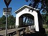 |
1939 | 1987-02-19 | Goar Road over Thomas Creek Thomas Creek (Oregon) Oregon has at least 19 features named Thomas Creek:... , north of Crabtree Crabtree, Oregon Crabtree is an unincorporated community in Linn County, Oregon, United States. Although it is unincorporated, it has a post office with a ZIP code of 97335. Crabtree lies off of Oregon Route 226 10 miles east of Albany.... 44.688°N 122.903°W |
Linn Linn County, Oregon Linn County is a county located in the U.S. state of Oregon. It is named in honor of Lewis F. Linn, a U.S. Senator from Missouri who advocated the American occupation of the Oregon Country. By the 2010 US census the population of Linn county was 116,672 showing a 13.2% growth since the 2000 census... |
Covered Covered bridge A covered bridge is a bridge with enclosed sides and a roof, often accommodating only a single lane of traffic. Most covered bridges are wooden; some newer ones are concrete or metal with glass sides... Howe truss |
| Thomas Creek-Shimanek Covered Bridge | 1966 | 1987-02-19 | Richardson Gap Road over Thomas Creek Thomas Creek (Oregon) Oregon has at least 19 features named Thomas Creek:... , northeast of Scio Scio, Oregon Scio is a city in Linn County, Oregon, United States. The population was 838 at the 2010 census.-Geography:According to the United States Census Bureau, the city has a total area of , all of it land.-History:... 44.716°N 122.804°W |
Linn Linn County, Oregon Linn County is a county located in the U.S. state of Oregon. It is named in honor of Lewis F. Linn, a U.S. Senator from Missouri who advocated the American occupation of the Oregon Country. By the 2010 US census the population of Linn county was 116,672 showing a 13.2% growth since the 2000 census... |
Covered Covered bridge A covered bridge is a bridge with enclosed sides and a roof, often accommodating only a single lane of traffic. Most covered bridges are wooden; some newer ones are concrete or metal with glass sides... Howe truss |
|
| Umpqua River Bridge No. 01822 | 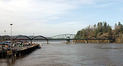 |
1936 | 2005-08-05 | US 101 over Umpqua River Umpqua River The Umpqua River on the Pacific coast of Oregon in the United States is approximately long. One of the principal rivers of the Oregon Coast and known for bass and shad, the river drains an expansive network of valleys in the mountains west of the Cascade Range and south of the Willamette Valley,... , Reedsport Reedsport, Oregon Reedsport is a city in Douglas County, Oregon, United States. As of the 2010 census, the population was 4,154.- History :Reedsport was established on the estuary of the Umpqua River on January 7, 1852. It was named for a local settler, Alfred W. Reed, who founded the city in 1912... 43.710°N 124.101°W |
Douglas Douglas County, Oregon -National protected areas:* Crater Lake National Park * Rogue River-Siskiyou National Forest * Siuslaw National Forest * Umpqua National Forest * Willamette National Forest -Adjacent counties:* Lane County, Oregon -... |
|
| Union Street Railroad Bridge and Trestle | 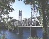 |
1913 | 2006-01-11 | Willamette River Willamette River The Willamette River is a major tributary of the Columbia River, accounting for 12 to 15 percent of the Columbia's flow. The Willamette's main stem is long, lying entirely in northwestern Oregon in the United States... , Salem Salem, Oregon Salem is the capital of the U.S. state of Oregon, and the county seat of Marion County. It is located in the center of the Willamette Valley alongside the Willamette River, which runs north through the city. The river forms the boundary between Marion and Polk counties, and the city neighborhood... 44.947°N 123.042°W |
Marion Marion County, Oregon Marion County is a county located in the U.S. state of Oregon. It was originally named the Champooick District, after Champoeg, a meeting place on the Willamette River. On September 3, 1849, the territorial legislature renamed it in honor of Francis Marion, a Continental Army general of the... |
Pratt through truss |
| Unity Bridge | 1936, 1975 | 1979-11-29 | Jasper Lowell Road over Fall Creek, Unity 43.945°N 122.775°W |
Lane Lane County, Oregon -National protected areas:*Oregon Islands National Wildlife Refuge *Siuslaw National Forest *Umpqua National Forest *Willamette National Forest -Government:... |
Covered Covered bridge A covered bridge is a bridge with enclosed sides and a roof, often accommodating only a single lane of traffic. Most covered bridges are wooden; some newer ones are concrete or metal with glass sides... Howe truss |
|
| Vista Avenue Viaduct |  |
1926 | 1984-04-26 | Vista Avenue over Canyon Road Canyon Road Canyon Road is a road connecting Beaverton and Portland, Oregon, United States. It was the first road between the Tualatin Valley and Portland and contributed significantly to Portland becoming the area's major deep water port, and subsequent early growth of the city.The total modern length is... , Portland Portland, Oregon Portland is a city located in the Pacific Northwest, near the confluence of the Willamette and Columbia rivers in the U.S. state of Oregon. As of the 2010 Census, it had a population of 583,776, making it the 29th most populous city in the United States... 45.519°N 122.698°W |
Multnomah Multnomah County, Oregon Multnomah County is one of 36 counties in the U.S. state of Oregon. Though smallest in area, it is the most populous as its county seat, Portland, is the state's largest city... |
|
| Wendling Bridge Wendling Bridge The Wendling Bridge, located in Lane County, Oregon, is listed on the National Register of Historic Places.... |
1938 | 1979-11-29 | Wendling Road over Mill Creek, Wendling Wendling, Oregon Wendling is an unincorporated community in Lane County, Oregon, United States, located northeast of Marcola. Wendling's post office operated from 1899 to 1952. It was named for X. Wendling, a local lumberman.... 44.191°N 122.799°W |
Lane Lane County, Oregon -National protected areas:*Oregon Islands National Wildlife Refuge *Siuslaw National Forest *Umpqua National Forest *Willamette National Forest -Government:... |
Covered Covered bridge A covered bridge is a bridge with enclosed sides and a roof, often accommodating only a single lane of traffic. Most covered bridges are wooden; some newer ones are concrete or metal with glass sides... Howe truss |
|
| Wildcat Creek Bridge Wildcat Creek Bridge Wildcat Creek Bridge is a covered bridge built in 1925 near Walton, Oregon. It uses Howe truss engineering and was listed on the National Register of Historic Places in 1979.... |
1925 | 1979-11-29 | Richardson Upriver Road over Wildcat Creek Wildcat Creek (Oregon) Wildcat Creek is a creek in both Lane County and in the Siuslaw National Forest. The creek empties into the Siuslaw River at Austa on Oregon Route 126.... , Walton Walton, Oregon Walton is an unincorporated community in Lane County, Oregon, United States. It is located halfway between Eugene and Florence on Oregon Route 126.... 44.003°N 123.655°W |
Lane Lane County, Oregon -National protected areas:*Oregon Islands National Wildlife Refuge *Siuslaw National Forest *Umpqua National Forest *Willamette National Forest -Government:... |
Covered Covered bridge A covered bridge is a bridge with enclosed sides and a roof, often accommodating only a single lane of traffic. Most covered bridges are wooden; some newer ones are concrete or metal with glass sides... Howe truss |
|
| Willamette River (Oregon City) Bridge (No. 357) |  |
1922 | 2005-07-01 | OR 43 over Willamette River Willamette River The Willamette River is a major tributary of the Columbia River, accounting for 12 to 15 percent of the Columbia's flow. The Willamette's main stem is long, lying entirely in northwestern Oregon in the United States... , Oregon City Oregon City, Oregon Oregon City was the first city in the United States west of the Rocky Mountains to be incorporated. It is the county seat of Clackamas County, Oregon... 45.359°N 122.610°W |
Clackamas Clackamas County, Oregon Clackamas County is a county located in the U.S. state of Oregon. The county was named after the Native Americans living in the area, the Clackamas Indians, who were part of the Chinookan people. As of 2010, the population was 375,992... |
Through arch |
| Wilson River Bridge No. 01499 |  |
1931 | 2005-08-05 | US 101 over Wilson River Wilson River (Oregon) The Wilson River is a stream, about long, that flows from the Northern Oregon Coast Range to Tillamook Bay in the U.S. state of Oregon. Formed by the confluence of its Devil's Lake Fork and its South Fork, it runs generally west through the Tillamook State Forest to its mouth near the city of... , north of Tillamook Tillamook, Oregon The city of Tillamook is the county seat of Tillamook County, Oregon, United States. The city is located on the southeast end of Tillamook Bay on the Pacific Ocean. The population was 4,352 at the 2000 census... 45.478°N 123.845°W |
Tillamook Tillamook County, Oregon Tillamook County is a county located in the U.S. state of Oregon. The county is named for the Tillamook, a Native American tribe who were living in the area in the early 19th century at the time of European American settlement. In 2010, the county's population was 25,250... |
|
| Yaquina Bay Bridge No. 01820 | 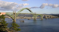 |
1936 | 2005-08-05 | US 101 over Yaquina Bay Yaquina Bay Yaquina Bay is a small bay partially within Newport, Oregon, United States, located where the Yaquina River flows into the Pacific Ocean. It is traversed by the Yaquina Bay Bridge. The bay's area is about 8 km² .-See also:... , Newport Newport, Oregon Newport is a city in Lincoln County, Oregon, United States. It was incorporated in 1882, though the name dates back to the establishment of a post office in 1868... 44.623°N 124.057°W |
Lincoln Lincoln County, Oregon -National protected areas:*Oregon Islands National Wildlife Refuge *Siletz Bay National Wildlife Refuge*Siuslaw National Forest -Demographics:... |
|
| Columbia River Highway Historic District |   |
1912–1921, 1937 | 1983-12-12 | Troutdale Troutdale, Oregon Troutdale is a city in Multnomah County, Oregon, north of Gresham and east of Wood Village. As of the 2010 census, the city population was 15,962.... to The Dalles The Dalles, Oregon The Dalles is the largest city and county seat of Wasco County, Oregon, United States. The name of the city comes from the French word dalle The Dalles is the largest city and county seat of Wasco County, Oregon, United States. The name of the city comes from the French word dalle The Dalles is... |
Multnomah Multnomah County, Oregon Multnomah County is one of 36 counties in the U.S. state of Oregon. Though smallest in area, it is the most populous as its county seat, Portland, is the state's largest city... , Hood River Hood River County, Oregon -Demographics:As of the census of 2000, there were 20,411 people, 7,248 households, and 5,175 families residing in the county. The population density was 39 people per square mile . There were 7,818 housing units at an average density of 15 per square mile... , Wasco Wasco County, Oregon Wasco County is a county located in the U.S. state of Oregon. The county is named for a local tribe of Native Americans, the Wasco, a Chinook tribe who lived on the south side of the Columbia River. In 2010, its population was 25,213... |
Multiple bridges and tunnels |
| Antelope Creek Bridge Antelope Creek Bridge The Antelope Creek Bridge is a wooden covered bridge that once crossed Antelope Creek near Medford, Oregon. It was listed on the National Register of Historic Places in 1979 but was delisted in 1988.... |
1922 | 1979-11-29 removed 1988-04-18 |
Main Street over Little Butte Creek Little Butte Creek (Rogue River) Little Butte Creek is a long tributary of the Rogue River located in the U.S. state of Oregon. Its drainage basin consists of approximately of Jackson County, and another in Klamath County. The north fork of the creek begins at Fish Lake, while the south fork begins near Brown Mountain. The two... , Eagle Point Eagle Point, Oregon Eagle Point is a city in Jackson County, Oregon, United States. The population was 8,469 at the 2010 census.-Geography:According to the United States Census Bureau, the city has a total area of , all of it land.-2000 Census data:... 42.472°N 122.800°W (moved) |
Jackson Jackson County, Oregon -National protected areas:* Cascade–Siskiyou National Monument* Crater Lake National Park * Klamath National Forest * Rogue River-Siskiyou National Forest * Umpqua National Forest -Demographics:... |
Covered Covered bridge A covered bridge is a bridge with enclosed sides and a roof, often accommodating only a single lane of traffic. Most covered bridges are wooden; some newer ones are concrete or metal with glass sides... modified queenpost truss |
|
| Brumbaugh Bridge | 1948, 1950 | 1979-11-29 removed 1986-11-25 |
Mosby Creek, southeast of Walden Walden, Oregon Walden is an unincorporated community in Lane County, Oregon, United States. Walden is southeast of Cottage Grove and uses the ZIP code 97424, which is a Cottage Grove ZIP code.... (destroyed) |
Lane Lane County, Oregon -National protected areas:*Oregon Islands National Wildlife Refuge *Siuslaw National Forest *Umpqua National Forest *Willamette National Forest -Government:... |
Covered Covered bridge A covered bridge is a bridge with enclosed sides and a roof, often accommodating only a single lane of traffic. Most covered bridges are wooden; some newer ones are concrete or metal with glass sides... Howe truss |
|
| Drift Creek Bridge | 1914 | 1979-11-29 removed 1998-07-21 |
Rogers Lane over Bear Creek, southeast of Otis Otis, Oregon Otis is an unincorporated community in Lincoln County, Oregon, United States, a half mile north of Otis Junction on Oregon Route 18. It is near the Salmon River.... 44.993°N 123.886°W (moved from Drift Creek Road over Drift Creek, southeast of Lincoln City Lincoln City, Oregon Lincoln City is a city in Lincoln County, Oregon, United States. It is named after the county. The population was 7,930 at the 2010 census.- History :... ) |
Lincoln Lincoln County, Oregon -National protected areas:*Oregon Islands National Wildlife Refuge *Siletz Bay National Wildlife Refuge*Siuslaw National Forest -Demographics:... |
Covered Covered bridge A covered bridge is a bridge with enclosed sides and a roof, often accommodating only a single lane of traffic. Most covered bridges are wooden; some newer ones are concrete or metal with glass sides... Howe truss |
|
| Elk City Bridge | 1922 | 1979-11-29 removed 1986-11-25 |
Yaquina River Yaquina River The Yaquina River is a river, approximately 50 mi long, on the Pacific coast of Oregon in the United States. It drains an area of the Central Oregon Coast Range west of the Willamette Valley near Newport.... , Elk City (destroyed) |
Lincoln Lincoln County, Oregon -National protected areas:*Oregon Islands National Wildlife Refuge *Siletz Bay National Wildlife Refuge*Siuslaw National Forest -Demographics:... |
Covered Covered bridge A covered bridge is a bridge with enclosed sides and a roof, often accommodating only a single lane of traffic. Most covered bridges are wooden; some newer ones are concrete or metal with glass sides... Howe truss |
|
| Horse Creek Bridge | 1930 | 1979-11-29 removed 1988-06-27 |
Myrtle Creek, Myrtle Creek Myrtle Creek, Oregon Myrtle Creek is a city in Douglas County, Oregon, United States. The population was 3,419 at the 2000 census.It is the birthplace of U.S. Senator Jeff Merkley.-Geography:... 43.023°N 123.290°W (moved from Horse Creek Road over Horse Creek, south of McKenzie Bridge McKenzie Bridge, Oregon McKenzie Bridge is an unincorporated community in Lane County, Oregon, United States, on the McKenzie River and within Willamette National Forest. It is located along Oregon Route 126, about 53 miles east of Eugene, between Rainbow and Belknap Springs... ) |
Lane Lane County, Oregon -National protected areas:*Oregon Islands National Wildlife Refuge *Siuslaw National Forest *Umpqua National Forest *Willamette National Forest -Government:... |
Covered Covered bridge A covered bridge is a bridge with enclosed sides and a roof, often accommodating only a single lane of traffic. Most covered bridges are wooden; some newer ones are concrete or metal with glass sides... |
|
| Irish Bend Bridge |  |
1954 | 1979-11-29 removed 1989-05-15 |
Campus Way over Oak Creek, Corvallis Corvallis, Oregon Corvallis is a city located in central western Oregon, United States. It is the county seat of Benton County and the principal city of the Corvallis, Oregon Metropolitan Statistical Area, which encompasses all of Benton County. As of the 2010 United States Census, the population was 54,462.... 44.567°N 123.301°W (moved from Irish Bend Road northeast of Monroe Monroe, Oregon Monroe is a city in Benton County, Oregon, United States. The population was 607 at the 2000 census. It is part of the "Corvallis, Oregon Metropolitan Statistical Area"... ) |
Benton Benton County, Oregon -National protected areas:*Siuslaw National Forest *William L. Finley National Wildlife Refuge-Demographics:As of the census of 2000, there were 78,153 people, 30,145 households, and 18,237 families residing in the county. The population density was 116 people per square mile . There were 31,980... |
Covered Covered bridge A covered bridge is a bridge with enclosed sides and a roof, often accommodating only a single lane of traffic. Most covered bridges are wooden; some newer ones are concrete or metal with glass sides... Howe truss |
| Pumping Station Bridge | 1916 | 1979-11-29 removed 1987-05-18 |
Rickreall Creek Rickreall Creek Rickreall Creek is a stream in Polk County, Oregon, United States rising on Laurel Mountain in the Central Oregon Coast Range and draining into the Willamette River west of Salem at Eola. The creek passes through the city of Dallas and the unincorporated community of Rickreall... , southwest of Ellendale Ellendale, Oregon Ellendale is a ghost town in Polk County, Oregon, United States, about two and a half miles west of Dallas. It was the first White settlement in present-day Polk County. The community's name changed over the years, with the first post office in Polk County being opened in this locality as "O'Neils... (destroyed) |
Polk Polk County, Oregon Polk County is a county located in the U.S. state of Oregon. The county is named for James Knox Polk, the 11th president of the United States. In 2010, its population was 75,403. The seat of the county is Dallas.... |
Covered Covered bridge A covered bridge is a bridge with enclosed sides and a roof, often accommodating only a single lane of traffic. Most covered bridges are wooden; some newer ones are concrete or metal with glass sides... |
|
| Roaring Camp Bridge | 1929 | 1979-11-29 removed 1996-01-17 |
Roaring Camp Lane over Elk Creek, west of Drain Drain, Oregon Drain is a city in Douglas County, Oregon, United States. The population was 1,021 at the 2000 census. The 2007 estimate is 1,075 residents. Drain is named after town founder and politician Charles J... 43.664°N 123.440°W (destroyed) |
Douglas Douglas County, Oregon -National protected areas:* Crater Lake National Park * Rogue River-Siskiyou National Forest * Siuslaw National Forest * Umpqua National Forest * Willamette National Forest -Adjacent counties:* Lane County, Oregon -... |
Covered Covered bridge A covered bridge is a bridge with enclosed sides and a roof, often accommodating only a single lane of traffic. Most covered bridges are wooden; some newer ones are concrete or metal with glass sides... Howe truss |
|
| Sam's Creek Bridge | 1922 | 1979-11-29 removed 1986-11-25 |
Sams Creek Road over Siletz River Siletz River The Siletz River flows about to the Pacific Ocean through coastal mountains in the U.S. state of Oregon. Formed by the confluence of its north and south forks near Valsetz in Polk County, it winds through the Central Oregon Coast Range. The river, draining a watershed of , empties into Siletz Bay,... , east of Siletz Siletz, Oregon Siletz is a city in Lincoln County, Oregon, United States. The population was 1,133 at the 2000 census. The city is located next to the Siletz Reservation and is the site of the annual Nesika Illahee Pow Wow in August.-Geography:... 44.733°N 123.843°W (destroyed) |
Lincoln Lincoln County, Oregon -National protected areas:*Oregon Islands National Wildlife Refuge *Siletz Bay National Wildlife Refuge*Siuslaw National Forest -Demographics:... |
Covered Covered bridge A covered bridge is a bridge with enclosed sides and a roof, often accommodating only a single lane of traffic. Most covered bridges are wooden; some newer ones are concrete or metal with glass sides... Howe truss |
|
| Weddle Bridge Weddle Bridge The Weddle Bridge is a 120-foot long wooden covered bridge located in Sweet Home, Oregon, United States.The bridge originally spanned Thomas Creek near Crabtree, Oregon. It was bypassed in 1980 by a concrete bridge. The unused bridge became a safety issue and the span was disassembled in October 1987... |
1937 | 1979-11-29 removed 1989-01-11 |
Ames Creek in Sweet Home Sweet Home, Oregon Sweet Home is a city in Linn County, Oregon, United States. The population was 8,016 at the 2000 census. Sweet Home is sometimes referred to as the "Gateway to the Santiam Playground", due to its proximity to nearby lakes, rivers and the Cascade Mountains.... 44.395°N 122.727°W (moved from Kelly Road over Thomas Creek Thomas Creek (Oregon) Oregon has at least 19 features named Thomas Creek:... southeast of Jefferson Jefferson, Oregon Jefferson is a city in Marion County, Oregon, United States. It is part of the Salem Metropolitan Statistical Area. The population was 2,487 at the 2000 census... ) |
Linn Linn County, Oregon Linn County is a county located in the U.S. state of Oregon. It is named in honor of Lewis F. Linn, a U.S. Senator from Missouri who advocated the American occupation of the Oregon Country. By the 2010 US census the population of Linn county was 116,672 showing a 13.2% growth since the 2000 census... |
Covered Covered bridge A covered bridge is a bridge with enclosed sides and a roof, often accommodating only a single lane of traffic. Most covered bridges are wooden; some newer ones are concrete or metal with glass sides... Howe truss |
|
| Wimer Bridge | 1927, 1962 | 1979-11-29 removed 2006-04-18 |
Covered Bridge Road over Evans Creek, Wimer Wimer, Oregon Wimer is an unincorporated community in Jackson County, Oregon, United States. Wimer is north of Rogue River.... 42.538°N 123.150°W (destroyed and rebuilt) |
Jackson Jackson County, Oregon -National protected areas:* Cascade–Siskiyou National Monument* Crater Lake National Park * Klamath National Forest * Rogue River-Siskiyou National Forest * Umpqua National Forest -Demographics:... |
Covered Covered bridge A covered bridge is a bridge with enclosed sides and a roof, often accommodating only a single lane of traffic. Most covered bridges are wooden; some newer ones are concrete or metal with glass sides... queenpost truss |