

Belknap Bridge
Encyclopedia
The Belknap Bridge crosses the McKenzie River
near the unincorporated
community of Rainbow
in Lane County
, Oregon
, United States
. It is approximately three miles west of the town of McKenzie Bridge
which is named after the bridge. It is the fourth covered bridge built on the site. The bridge is well maintained and open to traffic. The Belknap Bridge is listed on the National Register of Historic Places
.
, a total of 17 bridges, including 14 that are still open to traffic. There has been a covered bridge at the Belknap Bridge site since 1890 as four different bridge structures.
The original Belknap Bridge was built in 1890 by Mr. T. Thomson. It was named for a pioneer family that settled in the McKenzie River area, Rollin S. Belknap, who discovered and developed Belknap Springs
approximately nine miles upstream from the bridge. His son, J. H. Belknap, was involved in promoting a toll road over McKenzie Pass
in the early 1870s.
Traffic weakened the structure over time, so Lane County replaced it in 1911. The second bridge was replaced in 1939. That bridge, however, was destroyed in the Pacific Northwest flood of 1964. The current bridge opened in 1966. In 1975, louvered windows were added to the south side of the structure to improve the bridge's interior light. The bridge structure was strengthened and the exterior repaired in 1992. In 2002, a new roof was installed as part of a general bridge renovation project.
Because of its unique scenic beauty and its importance to Oregon's transportation history, the Belknap Bridge was listed on the National Register of Historic Places in 1979. Today, Lane County's Engineering Division maintains the covered bridges that are open to traffic, including the Belknap Bridge.
 The current Belknap Bridge was designed for Lane County by the Oregon Bridge Corporation of Springfield, Oregon
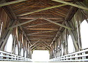
, as a classic covered bridge. It is 120 feet (36.6 m) long, containing a single span supported by a Howe truss system. Its maximum carrying capacity of 39 short tons (35 LT) is to accommodate logging
trucks. The bridge rests on two concrete foundation piers. Its wooden floor planks and shingled roof are in good condition, as is the weatherboard
housing that protects the Howe truss infrastructure from the elements.
Most of Oregon's covered bridges, including the Belknap Bridge, were built using the Howe truss system, developed in 1840 by the Massachusetts
architect William Howe
. The system uses heavy timbers reinforced with iron or steel rods. The trusses have central beams and crossed timbers with adjustable, vertical iron rods to support the structural load.
McKenzie River
The McKenzie River is a tributary of the Willamette River in western Oregon in the United States. It drains part of the Cascade Range east of Eugene and flows into the southernmost end of the Willamette Valley. It is named for Donald MacKenzie, a Scottish Canadian fur trader...
near the unincorporated
Unincorporated area
In law, an unincorporated area is a region of land that is not a part of any municipality.To "incorporate" in this context means to form a municipal corporation, a city, town, or village with its own government. An unincorporated community is usually not subject to or taxed by a municipal government...
community of Rainbow
Rainbow, Oregon
Rainbow is an unincorporated community in Lane County, Oregon, United States. It lies off Oregon Route 126, northeast of Eugene. Rainbow's elevation is . A post office was established on July 1, 1924, and closed August 31, 1937. The post office got its name from the rainbow trout that swim in the...
in Lane County
Lane County, Oregon
-National protected areas:*Oregon Islands National Wildlife Refuge *Siuslaw National Forest *Umpqua National Forest *Willamette National Forest -Government:...
, Oregon
Oregon
Oregon is a state in the Pacific Northwest region of the United States. It is located on the Pacific coast, with Washington to the north, California to the south, Nevada on the southeast and Idaho to the east. The Columbia and Snake rivers delineate much of Oregon's northern and eastern...
, United States
United States
The United States of America is a federal constitutional republic comprising fifty states and a federal district...
. It is approximately three miles west of the town of McKenzie Bridge
McKenzie Bridge, Oregon
McKenzie Bridge is an unincorporated community in Lane County, Oregon, United States, on the McKenzie River and within Willamette National Forest. It is located along Oregon Route 126, about 53 miles east of Eugene, between Rainbow and Belknap Springs...
which is named after the bridge. It is the fourth covered bridge built on the site. The bridge is well maintained and open to traffic. The Belknap Bridge is listed on the National Register of Historic Places
National Register of Historic Places
The National Register of Historic Places is the United States government's official list of districts, sites, buildings, structures, and objects deemed worthy of preservation...
.
History
Lane County was the first in Oregon to build covered bridges on a large scale. Today, the county has more surviving covered bridges than any other county west of the Mississippi RiverMississippi River
The Mississippi River is the largest river system in North America. Flowing entirely in the United States, this river rises in western Minnesota and meanders slowly southwards for to the Mississippi River Delta at the Gulf of Mexico. With its many tributaries, the Mississippi's watershed drains...
, a total of 17 bridges, including 14 that are still open to traffic. There has been a covered bridge at the Belknap Bridge site since 1890 as four different bridge structures.
The original Belknap Bridge was built in 1890 by Mr. T. Thomson. It was named for a pioneer family that settled in the McKenzie River area, Rollin S. Belknap, who discovered and developed Belknap Springs
Belknap Springs, Oregon
Belknap Springs is an unincorporated community and private hot springs resort in Lane County, Oregon, United States, near the McKenzie River. The springs were located and initially developed by R. S. Belknap in 1869. A post office named "Salt Springs" was established in the location in 1874, and...
approximately nine miles upstream from the bridge. His son, J. H. Belknap, was involved in promoting a toll road over McKenzie Pass
McKenzie Pass
McKenzie Pass is a mountain pass in the Cascade Range in central Oregon, United States.It is located at the border of Linn and Deschutes counties, approximately 20 mi northwest of Bend, between the Three Sisters to the south and Mt. Washington to the north...
in the early 1870s.
Traffic weakened the structure over time, so Lane County replaced it in 1911. The second bridge was replaced in 1939. That bridge, however, was destroyed in the Pacific Northwest flood of 1964. The current bridge opened in 1966. In 1975, louvered windows were added to the south side of the structure to improve the bridge's interior light. The bridge structure was strengthened and the exterior repaired in 1992. In 2002, a new roof was installed as part of a general bridge renovation project.
Because of its unique scenic beauty and its importance to Oregon's transportation history, the Belknap Bridge was listed on the National Register of Historic Places in 1979. Today, Lane County's Engineering Division maintains the covered bridges that are open to traffic, including the Belknap Bridge.
Structure
Springfield, Oregon
Springfield is a city in Lane County, Oregon, United States. Located in the Southern Willamette Valley, it is within the Eugene-Springfield Metropolitan Statistical Area. Separated from Eugene to the west, mainly by Interstate 5, Springfield is the second-most populous city in the metropolitan area...
, as a classic covered bridge. It is 120 feet (36.6 m) long, containing a single span supported by a Howe truss system. Its maximum carrying capacity of 39 short tons (35 LT) is to accommodate logging
Logging
Logging is the cutting, skidding, on-site processing, and loading of trees or logs onto trucks.In forestry, the term logging is sometimes used in a narrow sense concerning the logistics of moving wood from the stump to somewhere outside the forest, usually a sawmill or a lumber yard...
trucks. The bridge rests on two concrete foundation piers. Its wooden floor planks and shingled roof are in good condition, as is the weatherboard
Weatherboarding
Weatherboarding is the cladding or ‘siding’ of a house consisting of long thin timber boards that overlap one another, either vertically or horizontally on the outside of the wall. They are usually of rectangular section with parallel sides...
housing that protects the Howe truss infrastructure from the elements.
Most of Oregon's covered bridges, including the Belknap Bridge, were built using the Howe truss system, developed in 1840 by the Massachusetts
Massachusetts
The Commonwealth of Massachusetts is a state in the New England region of the northeastern United States of America. It is bordered by Rhode Island and Connecticut to the south, New York to the west, and Vermont and New Hampshire to the north; at its east lies the Atlantic Ocean. As of the 2010...
architect William Howe
William Howe (architect)
William Howe, born in 1803 in Spencer, Massachusetts, was an American bridge builder. He patented the Howe Truss design for covered bridges in 1840...
. The system uses heavy timbers reinforced with iron or steel rods. The trusses have central beams and crossed timbers with adjustable, vertical iron rods to support the structural load.