
Depoe Bay, Oregon
Encyclopedia
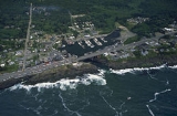
Depoe Bay is a city in Lincoln County
, Oregon
, United States
, located on U.S. Route 101
next to the Pacific Ocean
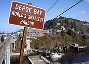
. The population was 1,174 at the 2000 census, with an unofficial estimated population of 1,355 in 2007. The bay of the same name is a six-acre (24,000 m²) harbor that the city promotes as the world's smallest.
Indian Charles "Charley" Depot who was originally allotted the land in 1894 as part of the Dawes Act of 1887. He was given the last name "Depot" when he worked at the military train depot near Toledo, Oregon. The family later changed their last name to "DePoe". His original tribal affiliation was Tututni.
In 1975, the fishing trip sequence in One Flew Over the Cuckoo's Nest
was filmed in Depoe Bay.
In 2008, restaurant scenes from The Burning Plain
were filmed in Depoe Bay, at the Tidal Raves restaurant.
On March 11, 2011, Depoe Bay's port was damaged by a tsunami
caused by the Tōhoku earthquake
off the coast of Japan
.
, the city has a total area of 1.8 square miles (4.7 km²), all of it land.
 As of the census
of 2000, there were 1,174 people, 584 households, and 359 families residing in the city. The population density
was 652.2 people per square mile (251.8/km²). There were 911 housing units at an average density of 506.1 per square mile (195.4/km²). The racial makeup of the city was 92.50% White, 0.34% African American, 1.70% Native American, 0.60% Asian, 0.17% Pacific Islander, 1.02% from other races
, and 3.66% from two or more races. Hispanic or Latino of any race were 3.58% of the population.
There were 584 households out of which 17.0% had children under the age of 18 living with them, 51.4% were married couples
living together, 7.0% had a female householder with no husband present, and 38.5% were non-families. 31.0% of all households were made up of individuals and 11.3% had someone living alone who was 65 years of age or older. The average household size was 2.01 and the average family size was 2.43.
In the city the population was spread out with 14.4% under the age of 18, 3.9% from 18 to 24, 22.1% from 25 to 44, 35.7% from 45 to 64, and 23.9% who were 65 years of age or older. The median age was 50 years. For every 100 females there were 99.0 males. For every 100 females age 18 and over, there were 93.6 males.
The median income for a household in the city was $35,417, and the median income for a family was $43,967. Males had a median income of $28,750 versus $25,469 for females. The per capita income
for the city was $24,994. About 5.5% of families and 8.0% of the population were below the poverty line, including 15.1% of those under age 18 and 2.1% of those age 65 or over.
44.807327°N 124.062193°W
Lincoln County, Oregon
-National protected areas:*Oregon Islands National Wildlife Refuge *Siletz Bay National Wildlife Refuge*Siuslaw National Forest -Demographics:...
, Oregon
Oregon
Oregon is a state in the Pacific Northwest region of the United States. It is located on the Pacific coast, with Washington to the north, California to the south, Nevada on the southeast and Idaho to the east. The Columbia and Snake rivers delineate much of Oregon's northern and eastern...
, United States
United States
The United States of America is a federal constitutional republic comprising fifty states and a federal district...
, located on U.S. Route 101
U.S. Route 101 in Oregon
In the U.S. state of Oregon, U.S. Route 101, a major north–south U.S. Highway, runs through the state along the coastline near the Pacific Ocean. In Oregon, it runs from the Oregon–California border, south of Brookings, to the Oregon–Washington border on the Columbia River, between Astoria,...
next to the Pacific Ocean
Pacific Ocean
The Pacific Ocean is the largest of the Earth's oceanic divisions. It extends from the Arctic in the north to the Southern Ocean in the south, bounded by Asia and Australia in the west, and the Americas in the east.At 165.2 million square kilometres in area, this largest division of the World...
. The population was 1,174 at the 2000 census, with an unofficial estimated population of 1,355 in 2007. The bay of the same name is a six-acre (24,000 m²) harbor that the city promotes as the world's smallest.
History
Depoe Bay was named for SiletzConfederated Tribes of Siletz
The Confederated Tribes of Siletz Indians in the United States is a federally recognized confederation of 27 Native American tribal bands that once inhabited a range from northern California to southwest Washington.-Tribes:...
Indian Charles "Charley" Depot who was originally allotted the land in 1894 as part of the Dawes Act of 1887. He was given the last name "Depot" when he worked at the military train depot near Toledo, Oregon. The family later changed their last name to "DePoe". His original tribal affiliation was Tututni.
In 1975, the fishing trip sequence in One Flew Over the Cuckoo's Nest
One Flew Over the Cuckoo's Nest (film)
One Flew Over the Cuckoo's Nest is a 1975 American drama film directed by Miloš Forman and based on the 1962 novel of the same name by Ken Kesey....
was filmed in Depoe Bay.
In 2008, restaurant scenes from The Burning Plain
The Burning Plain
The Burning Plain is a 2008 drama film directed and written by Guillermo Arriaga, the screenwriter of Amores perros , 21 Grams , and Babel . The film stars Charlize Theron, Jennifer Lawrence, Kim Basinger and Joaquim de Almeida...
were filmed in Depoe Bay, at the Tidal Raves restaurant.
On March 11, 2011, Depoe Bay's port was damaged by a tsunami
Tsunami
A tsunami is a series of water waves caused by the displacement of a large volume of a body of water, typically an ocean or a large lake...
caused by the Tōhoku earthquake
2011 Tōhoku earthquake and tsunami
The 2011 earthquake off the Pacific coast of Tohoku, also known as the 2011 Tohoku earthquake, or the Great East Japan Earthquake, was a magnitude 9.0 undersea megathrust earthquake off the coast of Japan that occurred at 14:46 JST on Friday, 11 March 2011, with the epicenter approximately east...
off the coast of Japan
Japan
Japan is an island nation in East Asia. Located in the Pacific Ocean, it lies to the east of the Sea of Japan, China, North Korea, South Korea and Russia, stretching from the Sea of Okhotsk in the north to the East China Sea and Taiwan in the south...
.
Geography
According to the United States Census BureauUnited States Census Bureau
The United States Census Bureau is the government agency that is responsible for the United States Census. It also gathers other national demographic and economic data...
, the city has a total area of 1.8 square miles (4.7 km²), all of it land.
Demographics
Census
A census is the procedure of systematically acquiring and recording information about the members of a given population. It is a regularly occurring and official count of a particular population. The term is used mostly in connection with national population and housing censuses; other common...
of 2000, there were 1,174 people, 584 households, and 359 families residing in the city. The population density
Population density
Population density is a measurement of population per unit area or unit volume. It is frequently applied to living organisms, and particularly to humans...
was 652.2 people per square mile (251.8/km²). There were 911 housing units at an average density of 506.1 per square mile (195.4/km²). The racial makeup of the city was 92.50% White, 0.34% African American, 1.70% Native American, 0.60% Asian, 0.17% Pacific Islander, 1.02% from other races
Race (United States Census)
Race and ethnicity in the United States Census, as defined by the Federal Office of Management and Budget and the United States Census Bureau, are self-identification data items in which residents choose the race or races with which they most closely identify, and indicate whether or not they are...
, and 3.66% from two or more races. Hispanic or Latino of any race were 3.58% of the population.
There were 584 households out of which 17.0% had children under the age of 18 living with them, 51.4% were married couples
Marriage
Marriage is a social union or legal contract between people that creates kinship. It is an institution in which interpersonal relationships, usually intimate and sexual, are acknowledged in a variety of ways, depending on the culture or subculture in which it is found...
living together, 7.0% had a female householder with no husband present, and 38.5% were non-families. 31.0% of all households were made up of individuals and 11.3% had someone living alone who was 65 years of age or older. The average household size was 2.01 and the average family size was 2.43.
In the city the population was spread out with 14.4% under the age of 18, 3.9% from 18 to 24, 22.1% from 25 to 44, 35.7% from 45 to 64, and 23.9% who were 65 years of age or older. The median age was 50 years. For every 100 females there were 99.0 males. For every 100 females age 18 and over, there were 93.6 males.
The median income for a household in the city was $35,417, and the median income for a family was $43,967. Males had a median income of $28,750 versus $25,469 for females. The per capita income
Per capita income
Per capita income or income per person is a measure of mean income within an economic aggregate, such as a country or city. It is calculated by taking a measure of all sources of income in the aggregate and dividing it by the total population...
for the city was $24,994. About 5.5% of families and 8.0% of the population were below the poverty line, including 15.1% of those under age 18 and 2.1% of those age 65 or over.
Media
Depoe Bay is served by radio station KPPT FM. It specializes in classic hits and is licensed to broadcast at 100.7 MHz.See also
- Whale CoveWhale Cove (Oregon)Whale Cove is a small cove, approximately one-third of a mile in diameter, located on the Pacific Coast of Oregon in the United States, approximately 2 mi south of the city of Depoe Bay...
- Whale Watching CenterWhale Watching CenterThe Whale Watching Center is an Oregon State Parks staffed visitor center in Depoe Bay, Oregon, U.S.A. to help visitors observe whale migration and provide information about whales and other marine mammals including history, economics, and their environmental and ecological influences.Approximately...
, a state park featuring a staffed visitor center
External links
- Entry for Depoe Bay in the Oregon Blue BookOregon Blue BookThe Oregon Blue Book is the official directory and fact book for the U.S. state of Oregon copyrighted by the Oregon Secretary of State and published by the Office of the Secretary's Archives Division. As Governor Ted Kulongoski notes in his introduction for the 2005–2006 edition, it "provides...
44.807327°N 124.062193°W