

Wasco County, Oregon
Encyclopedia
Wasco County is a county located in the U.S. state
of Oregon
. The county is named for
a local tribe of Native Americans
, the Wasco, a Chinook tribe who lived on the south side of the Columbia River
. In 2010, its population was 25,213. Its county seat
is The Dalles
.
, the county has a total area of 2395 square miles (6,203 km²), of which 2381 square miles (6,166.8 km²) is land and 14 square miles (36.3 km²) (0.60%) is water. The northern boundary is the Columbia River
(the state line).
on the Columbia River served as a gathering place and major trading center for the local Native Americans, including the Wasco, Paiute
, and Warm Springs tribes, for thousands of years. These rapids came to be named Les Grandes Dalles de la Columbia or "The Great Falls of the Columbia" by the French Canadian fur traders.
The Dalles served initially as a way station on the Oregon Trail
as it approached the Willamette Valley
. The construction of the Barlow Road
over the Cascades
in 1845, and the Donation Land Claim Act of 1850 encouraged families to settle in the area. Over the following years, Wasco County was a major transportation hub for both river and inland traffic.
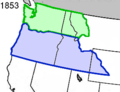
The Oregon Territorial Legislature
created Wasco County on January 11, 1854 from the parts of Clackamas
, Lane
, Linn
and Marion
counties, that were east of the Cascade Range
. At the time of its creation, it was the largest county in the United States, consisting of 130000 square miles (336,698.5 km²) that stretched clear to the Rocky Mountains
. Its northern border was the Washington Territory
line (the Columbia River
). When Dakota Territory
(including present-day Wyoming
) was created in 1861, Idaho Territory
in 1863, and Montana Territory
in 1864, the parts of Wasco County east of the present Oregon boundaries were ceded to those territories. Other Oregon counties were split away, and Wasco was reduced to its current size.
The Dalles was designated the county seat with the creation of the county, and has been its only location.
The river traffic on the Columbia River was profoundly affected in 1935 by the building of Bonneville Dam
in Multnomah County
and by The Dalles Dam in 1957 in Wasco County (which submerged Celilo Falls).
Wasco County attracted international attention in the 1980s, when Bhagwan Shree Rajneesh
went to the United States and settled for several years at a marginal ranch called "The Big Muddy", but later known as Rajneeshpuram
. Disagreements over zoning rules and building codes in the beginning continued to escalate between not only his followers and the inhabitants of Wasco County, but eventually with the rest of the state. His followers, known as Rajneeshees, settled en bloc in Antelope, Oregon
and were able to elect a majority of the town councillors. Acerbic, if not hostile comments by his spokeswoman, Ma Anand Sheela
, only increased tensions, and were not helped by Rajneesh's vow of silence
. When the Rajneeshees subsequently recruited homeless people
from across the United States to settle at Rajneeshpuram, it was widely seen as an attempt to use the ballot box to seize control of the county. But perhaps the most bizarre turn of events was when an outbreak of salmonella
in salad bars at ten restaurants in The Dalles were traced to the acts of his followers. About this time, Sheela was removed from her post in Rajneesh's service.
This chapter in the county's history finally ended in 1985, when Rajneesh was arrested as he was fleeing the U.S. On October 23, 1985, a federal grand jury in Portland had secretly indicted Rajneesh, Sheela, and six other of his followers for immigration crimes. Two days later, a Wasco County grand jury returned indictments against Sheela and two others, charging them with the attempted murder of Swami Devaraj, Rajneesh's personal doctor. Rajneesh entered an Alford plea
and was given a suspended sentence on condition that he leave the country.
The former Rajneesh ranch is now known as "Wildhorse Canyon". It is owned and operated by Young Life Ministries
, a Christian
organization providing camp services for youth.
of 2000, there were 23,791 people, 9,401 households, and 6,505 families residing in the county. The population density
was 10 people per square mile (4/km²). There were 10,651 housing units at an average density of 4 per square mile (2/km²). The racial makeup of the county was 86.58% White
, 3.81% Native American
, 0.80% Asian
, 0.50% Pacific Islander
, 0.30% Black
or African American
, 5.65% from other races
, and 2.36% from two or more races. 9.31% of the population were Hispanic or Latino
of any race. 17.8% were of German, 11.8% English
, 9.8% American
, 9.5% Irish
and 5.0% Norwegian ancestry according to Census 2000.
There were 9,401 households out of which 30.20% had children under the age of 18 living with them, 54.80% were married couples
living together, 9.90% had a female householder with no husband present, and 30.80% were non-families. 26.10% of all households were made up of individuals and 11.50% had someone living alone who was 65 years of age or older. The average household size was 2.47 and the average family size was 2.96.
In the county, the population was spread out with 25.40% under the age of 18, 7.40% from 18 to 24, 25.20% from 25 to 44, 25.40% from 45 to 64, and 16.70% who were 65 years of age or older. The median age was 40 years. For every 100 females there were 97.90 males. For every 100 females age 18 and over, there were 95.10 males.
The median income for a household in the county was $35,959, and the median income for a family was $42,412. Males had a median income of $36,051 versus $21,575 for females. The per capita income
for the county was $17,195. About 10.30% of families and 12.90% of the population were below the poverty line, including 17.70% of those under age 18 and 7.30% of those age 65 or over.
, Hood River
, and Sherman
counties.
U.S. state
A U.S. state is any one of the 50 federated states of the United States of America that share sovereignty with the federal government. Because of this shared sovereignty, an American is a citizen both of the federal entity and of his or her state of domicile. Four states use the official title of...
of Oregon
Oregon
Oregon is a state in the Pacific Northwest region of the United States. It is located on the Pacific coast, with Washington to the north, California to the south, Nevada on the southeast and Idaho to the east. The Columbia and Snake rivers delineate much of Oregon's northern and eastern...
. The county is named for
Oregon Geographic Names
Oregon Geographic Names is an authoritative compilation of the origin and meaning of place names in the U.S. state of Oregon. , the book is in its seventh edition and is compiled and edited by Lewis L. McArthur, who took over from his father, Lewis A. McArthur, as of the fourth edition...
a local tribe of Native Americans
Native Americans in the United States
Native Americans in the United States are the indigenous peoples in North America within the boundaries of the present-day continental United States, parts of Alaska, and the island state of Hawaii. They are composed of numerous, distinct tribes, states, and ethnic groups, many of which survive as...
, the Wasco, a Chinook tribe who lived on the south side of the Columbia River
Columbia River
The Columbia River is the largest river in the Pacific Northwest region of North America. The river rises in the Rocky Mountains of British Columbia, Canada, flows northwest and then south into the U.S. state of Washington, then turns west to form most of the border between Washington and the state...
. In 2010, its population was 25,213. Its county seat
County seat
A county seat is an administrative center, or seat of government, for a county or civil parish. The term is primarily used in the United States....
is The Dalles
The Dalles, Oregon
The Dalles is the largest city and county seat of Wasco County, Oregon, United States. The name of the city comes from the French word dalle The Dalles is the largest city and county seat of Wasco County, Oregon, United States. The name of the city comes from the French word dalle The Dalles is...
.
Economy
The county's economy is based upon agriculture (orchards, wheat farming, livestock ranching), lumber, manufacturing, electric power, transportation, and tourism. Aluminum production was previously a major support of the local economy, but electrical price fluctuations and a slump in global aluminum prices has forced the closing of a number of local aluminum foundries.Geography
According to the U.S. Census BureauUnited States Census Bureau
The United States Census Bureau is the government agency that is responsible for the United States Census. It also gathers other national demographic and economic data...
, the county has a total area of 2395 square miles (6,203 km²), of which 2381 square miles (6,166.8 km²) is land and 14 square miles (36.3 km²) (0.60%) is water. The northern boundary is the Columbia River
Columbia River
The Columbia River is the largest river in the Pacific Northwest region of North America. The river rises in the Rocky Mountains of British Columbia, Canada, flows northwest and then south into the U.S. state of Washington, then turns west to form most of the border between Washington and the state...
(the state line).
Adjacent counties
- Hood River County, OregonHood River County, Oregon-Demographics:As of the census of 2000, there were 20,411 people, 7,248 households, and 5,175 families residing in the county. The population density was 39 people per square mile . There were 7,818 housing units at an average density of 15 per square mile...
- west - Clackamas County, OregonClackamas County, OregonClackamas County is a county located in the U.S. state of Oregon. The county was named after the Native Americans living in the area, the Clackamas Indians, who were part of the Chinookan people. As of 2010, the population was 375,992...
- west - Marion County, OregonMarion County, OregonMarion County is a county located in the U.S. state of Oregon. It was originally named the Champooick District, after Champoeg, a meeting place on the Willamette River. On September 3, 1849, the territorial legislature renamed it in honor of Francis Marion, a Continental Army general of the...
- southwest - Jefferson County, OregonJefferson County, OregonJefferson County is a county located in the U.S. state of Oregon. In 2010, its population was 21,720. It is named after Mount Jefferson. The seat of the county is Madras.-History:...
- south - Wheeler County, OregonWheeler County, OregonAs of the census of 2000, there were 1,547 people, 653 households, and 444 families residing in the county. The population density was 1 people per square mile . There were 842 housing units at an average density of 0 per square mile...
- southeast - Gilliam County, OregonGilliam County, Oregon-Demographics:As of the census of 2000, there were 1,915 people, 819 households, and 543 families residing in the county. The population density was 2 people per square mile . There were 1,043 housing units at an average density of 1 per square mile...
- east - Sherman County, OregonSherman County, OregonSherman County is a county located in the U.S. state of Oregon. The county is named for William Tecumseh Sherman, a Union general in the American Civil War. In 2010, its population was 1,765. The seat of the county is Moro. The largest city is Wasco....
- east - Klickitat County, Washington - north
History
Celilo FallsCelilo Falls
Celilo Falls was a tribal fishing area on the Columbia River, just east of the Cascade Mountains, on what is today the border between the U.S. states of Oregon and Washington...
on the Columbia River served as a gathering place and major trading center for the local Native Americans, including the Wasco, Paiute
Paiute
Paiute refers to three closely related groups of Native Americans — the Northern Paiute of California, Idaho, Nevada and Oregon; the Owens Valley Paiute of California and Nevada; and the Southern Paiute of Arizona, southeastern California and Nevada, and Utah.-Origin of name:The origin of...
, and Warm Springs tribes, for thousands of years. These rapids came to be named Les Grandes Dalles de la Columbia or "The Great Falls of the Columbia" by the French Canadian fur traders.
The Dalles served initially as a way station on the Oregon Trail
Oregon Trail
The Oregon Trail is a historic east-west wagon route that connected the Missouri River to valleys in Oregon and locations in between.After 1840 steam-powered riverboats and steamboats traversing up and down the Ohio, Mississippi and Missouri rivers sped settlement and development in the flat...
as it approached the Willamette Valley
Willamette Valley
The Willamette Valley is the most populated region in the state of Oregon of the United States. Located in the state's northwest, the region is surrounded by tall mountain ranges to the east, west and south and the valley's floor is broad, flat and fertile because of Ice Age conditions...
. The construction of the Barlow Road
Barlow Road
The Barlow Road is a historic road in what is now the U.S. state of Oregon. It was built in 1846 by Sam Barlow and Philip Foster, with authorization of the Provisional Legislature of Oregon, and served as the last overland segment of the Oregon Trail...
over the Cascades
Cascade Range
The Cascade Range is a major mountain range of western North America, extending from southern British Columbia through Washington and Oregon to Northern California. It includes both non-volcanic mountains, such as the North Cascades, and the notable volcanoes known as the High Cascades...
in 1845, and the Donation Land Claim Act of 1850 encouraged families to settle in the area. Over the following years, Wasco County was a major transportation hub for both river and inland traffic.
The Oregon Territorial Legislature
Oregon Territorial Legislature
Oregon’s Territorial Legislature was a bicameral legislative body created by the United States Congress in 1848 as the legislative branch of the government of the Oregon Territory...
created Wasco County on January 11, 1854 from the parts of Clackamas
Clackamas County, Oregon
Clackamas County is a county located in the U.S. state of Oregon. The county was named after the Native Americans living in the area, the Clackamas Indians, who were part of the Chinookan people. As of 2010, the population was 375,992...
, Lane
Lane County, Oregon
-National protected areas:*Oregon Islands National Wildlife Refuge *Siuslaw National Forest *Umpqua National Forest *Willamette National Forest -Government:...
, Linn
Linn County, Oregon
Linn County is a county located in the U.S. state of Oregon. It is named in honor of Lewis F. Linn, a U.S. Senator from Missouri who advocated the American occupation of the Oregon Country. By the 2010 US census the population of Linn county was 116,672 showing a 13.2% growth since the 2000 census...
and Marion
Marion County, Oregon
Marion County is a county located in the U.S. state of Oregon. It was originally named the Champooick District, after Champoeg, a meeting place on the Willamette River. On September 3, 1849, the territorial legislature renamed it in honor of Francis Marion, a Continental Army general of the...
counties, that were east of the Cascade Range
Cascade Range
The Cascade Range is a major mountain range of western North America, extending from southern British Columbia through Washington and Oregon to Northern California. It includes both non-volcanic mountains, such as the North Cascades, and the notable volcanoes known as the High Cascades...
. At the time of its creation, it was the largest county in the United States, consisting of 130000 square miles (336,698.5 km²) that stretched clear to the Rocky Mountains
Rocky Mountains
The Rocky Mountains are a major mountain range in western North America. The Rocky Mountains stretch more than from the northernmost part of British Columbia, in western Canada, to New Mexico, in the southwestern United States...
. Its northern border was the Washington Territory
Washington Territory
The Territory of Washington was an organized incorporated territory of the United States that existed from February 8, 1853, until November 11, 1889, when the final extent of the territory was admitted to the Union as the State of Washington....
line (the Columbia River
Columbia River
The Columbia River is the largest river in the Pacific Northwest region of North America. The river rises in the Rocky Mountains of British Columbia, Canada, flows northwest and then south into the U.S. state of Washington, then turns west to form most of the border between Washington and the state...
). When Dakota Territory
Dakota Territory
The Territory of Dakota was an organized incorporated territory of the United States that existed from March 2, 1861, until November 2, 1889, when the final extent of the reduced territory was split and admitted to the Union as the states of North and South Dakota.The Dakota Territory consisted of...
(including present-day Wyoming
Wyoming
Wyoming is a state in the mountain region of the Western United States. The western two thirds of the state is covered mostly with the mountain ranges and rangelands in the foothills of the Eastern Rocky Mountains, while the eastern third of the state is high elevation prairie known as the High...
) was created in 1861, Idaho Territory
Idaho Territory
The Territory of Idaho was an organized incorporated territory of the United States that existed from March 4, 1863, until July 3, 1890, when the final extent of the territory was admitted to the Union as the State of Idaho.-1860s:...
in 1863, and Montana Territory
Montana Territory
The Territory of Montana was an organized incorporated territory of the United States that existed from May 28, 1864, until November 8, 1889, when it was admitted to the Union as the State of Montana.-History:...
in 1864, the parts of Wasco County east of the present Oregon boundaries were ceded to those territories. Other Oregon counties were split away, and Wasco was reduced to its current size.
| Dates of Secession of Other Eastern Oregon Counties | |
| County | Secession Date |
| Baker Baker County, Oregon Baker County is a county located in the U.S. state of Oregon. It is included in the 8 county definition of Eastern Oregon. It is named for Edward Dickinson Baker, a senator from Oregon who was killed at Ball's Bluff, a battle of the Civil War in Virginia in 1861. It was split from the eastern part... |
1862 |
| Umatilla Umatilla County, Oregon Umatilla County is a county located in the U.S. state of Oregon. It is included in the 8 county definition of Eastern Oregon. The county is named for the Umatilla River. In 2010, its population was 75,889... |
1862 |
| Grant Grant County, Oregon Grant County is a county located in the U.S. state of Oregon. It is included in the 8 county definition of Eastern Oregon. In 2010, its population was 7,445. It is named for President Ulysses S. Grant, who served as an army officer in the Oregon Territory, and at the time of the county's creation... |
1864 |
| Lake Lake County, Oregon Lake County is a county in the high desert south central region of the U.S. state of Oregon, so named for the many lakes found within its boundaries, including Lake Abert, Hart Lake Reservoir, and Goose Lake. While Lake is among Oregon's largest counties, it is sparsely populated with 7,895... |
1874 |
| Crook Crook County, Oregon -Demographics:As of the census of 2000, there were 19,182 people, 7,354 households, and 5,427 families residing in the county. The population density was 6 people per square mile . There were 8,264 housing units at an average density of 3 per square mile... |
1882 |
| Morrow Morrow County, Oregon Morrow County is a county located in the U.S. state of Oregon, on the south side of the Columbia River. It is included in the 8 county definition of Eastern Oregon. The county is named for one of its first white settlers, Jackson L. Morrow, who was a member of the state legislature when the county... |
1884 |
| Gilliam Gilliam County, Oregon -Demographics:As of the census of 2000, there were 1,915 people, 819 households, and 543 families residing in the county. The population density was 2 people per square mile . There were 1,043 housing units at an average density of 1 per square mile... |
1885 |
| Sherman Sherman County, Oregon Sherman County is a county located in the U.S. state of Oregon. The county is named for William Tecumseh Sherman, a Union general in the American Civil War. In 2010, its population was 1,765. The seat of the county is Moro. The largest city is Wasco.... |
1889 |
| Hood River | 1908 |
The Dalles was designated the county seat with the creation of the county, and has been its only location.
The river traffic on the Columbia River was profoundly affected in 1935 by the building of Bonneville Dam
Bonneville Dam
Bonneville Lock and Dam consists of several run-of-the-river dam structures that together complete a span of the Columbia River between the U.S. states of Oregon and Washington at River Mile 146.1. The dam is located east of Portland, Oregon, in the Columbia River Gorge. The primary functions of...
in Multnomah County
Multnomah County, Oregon
Multnomah County is one of 36 counties in the U.S. state of Oregon. Though smallest in area, it is the most populous as its county seat, Portland, is the state's largest city...
and by The Dalles Dam in 1957 in Wasco County (which submerged Celilo Falls).
Wasco County attracted international attention in the 1980s, when Bhagwan Shree Rajneesh
Osho (Bhagwan Shree Rajneesh)
Osho , born Chandra Mohan Jain , and also known as Acharya Rajneesh from the 1960s onwards, as Bhagwan Shree Rajneesh during the 1970s and 1980s and as Osho from 1989, was an Indian mystic, guru, and spiritual teacher who garnered an international following.A professor of philosophy, he travelled...
went to the United States and settled for several years at a marginal ranch called "The Big Muddy", but later known as Rajneeshpuram
Rajneeshpuram
Rajneeshpuram, Oregon was an intentional community in Wasco County, Oregon, briefly incorporated as a city in the 1980s, which was populated with followers of the spiritual teacher Osho, then known as Bhagwan Shree Rajneesh.- History :...
. Disagreements over zoning rules and building codes in the beginning continued to escalate between not only his followers and the inhabitants of Wasco County, but eventually with the rest of the state. His followers, known as Rajneeshees, settled en bloc in Antelope, Oregon
Antelope, Oregon
Antelope is a city in Wasco County, Oregon, United States. As of the 2010 Census, the population was 46.-History:The Antelope Valley was probably named by members of Joseph Sherar's party who were packing supplies to mines in the John Day area. Sherar became known as the operator of a toll bridge...
and were able to elect a majority of the town councillors. Acerbic, if not hostile comments by his spokeswoman, Ma Anand Sheela
Ma Anand Sheela
Ma Anand Sheela is a former follower, secretary and spokeswoman for the Indian mystic and spiritual teacher Bhagwan Shree Rajneesh, now commonly known as Osho...
, only increased tensions, and were not helped by Rajneesh's vow of silence
Vow of silence
A vow of silence is a religious vow, usually taken in a monastic context, to maintain silence. Known as Mauna in Hinduism, Jainism, and Buddhism, the practice is integral to Christian and Islamic traditions as well...
. When the Rajneeshees subsequently recruited homeless people
Homelessness
Homelessness describes the condition of people without a regular dwelling. People who are homeless are unable or unwilling to acquire and maintain regular, safe, and adequate housing, or lack "fixed, regular, and adequate night-time residence." The legal definition of "homeless" varies from country...
from across the United States to settle at Rajneeshpuram, it was widely seen as an attempt to use the ballot box to seize control of the county. But perhaps the most bizarre turn of events was when an outbreak of salmonella
Salmonella
Salmonella is a genus of rod-shaped, Gram-negative, non-spore-forming, predominantly motile enterobacteria with diameters around 0.7 to 1.5 µm, lengths from 2 to 5 µm, and flagella which grade in all directions . They are chemoorganotrophs, obtaining their energy from oxidation and reduction...
in salad bars at ten restaurants in The Dalles were traced to the acts of his followers. About this time, Sheela was removed from her post in Rajneesh's service.
This chapter in the county's history finally ended in 1985, when Rajneesh was arrested as he was fleeing the U.S. On October 23, 1985, a federal grand jury in Portland had secretly indicted Rajneesh, Sheela, and six other of his followers for immigration crimes. Two days later, a Wasco County grand jury returned indictments against Sheela and two others, charging them with the attempted murder of Swami Devaraj, Rajneesh's personal doctor. Rajneesh entered an Alford plea
Alford plea
An Alford plea in United States law is a guilty plea in criminal court, where the defendant does not admit the act and asserts innocence...
and was given a suspended sentence on condition that he leave the country.
The former Rajneesh ranch is now known as "Wildhorse Canyon". It is owned and operated by Young Life Ministries
Young Life
YoungLife is a worldwide, non-profit, Evangelical Christian organization. YoungLife consists of many branches of ministry , but most commonly the name "YoungLife" refers to the outreach arm of the organization directed toward high school students...
, a Christian
Christianity
Christianity is a monotheistic religion based on the life and teachings of Jesus as presented in canonical gospels and other New Testament writings...
organization providing camp services for youth.
Incorporated cities
- AntelopeAntelope, OregonAntelope is a city in Wasco County, Oregon, United States. As of the 2010 Census, the population was 46.-History:The Antelope Valley was probably named by members of Joseph Sherar's party who were packing supplies to mines in the John Day area. Sherar became known as the operator of a toll bridge...
- DufurDufur, OregonDufur is a city in Wasco County, Oregon, United States. The population was 588 at the 2000 census. It is a farming community, with wheat being an important crop, along with tree fruit and grapes....
- MaupinMaupin, OregonMaupin is a city in Wasco County, Oregon, United States. Located on the Deschutes River, much of the city's economy is related to the river through outdoor activities, such as fishing and rafting...
- MosierMosier, OregonMosier is a city in Wasco County, Oregon, United States. The population was 410 at the 2000 census.-History:Mosier was first settled in 1854 and incorporated as a city in 1914. The building now known as the post office was at that time the bank, and the original safe is still intact on-site. ...
- ShanikoShaniko, OregonShaniko is a city located in Wasco County, Oregon, United States, on U.S. Route 97 and about eight miles north of Antelope. As of the 2000 census, the city had a population of 26—a virtual ghost town whose preservation is being spearheaded by investments from Robert B...
- The DallesThe Dalles, OregonThe Dalles is the largest city and county seat of Wasco County, Oregon, United States. The name of the city comes from the French word dalle The Dalles is the largest city and county seat of Wasco County, Oregon, United States. The name of the city comes from the French word dalle The Dalles is...
Unincorporated communities and CDPs
|
Rowena, Oregon Rowena is an unincorporated community in Wasco County, Oregon, United States. For statistical purposes, the United States Census Bureau has defined Rowena as a census-designated place . The census definition of the area may not precisely correspond to local understanding of the area with the same... Tygh Valley, Oregon * Annual Average High Temperatures: 86 °F 41 °F * Annual Average Low Temperatures 50 °F 26 °F * Highest Recorded Temperature: 110 °F * Lowest Recorded Temperature: -28 °F... Wamic, Oregon Wamic is a census-designated place and unincorporated community in Wasco County, Oregon, United States. The population was 36 at the 2000 census.-Geography:Wamic is located at .... |
Demographics
As of the censusCensus
A census is the procedure of systematically acquiring and recording information about the members of a given population. It is a regularly occurring and official count of a particular population. The term is used mostly in connection with national population and housing censuses; other common...
of 2000, there were 23,791 people, 9,401 households, and 6,505 families residing in the county. The population density
Population density
Population density is a measurement of population per unit area or unit volume. It is frequently applied to living organisms, and particularly to humans...
was 10 people per square mile (4/km²). There were 10,651 housing units at an average density of 4 per square mile (2/km²). The racial makeup of the county was 86.58% White
Race (United States Census)
Race and ethnicity in the United States Census, as defined by the Federal Office of Management and Budget and the United States Census Bureau, are self-identification data items in which residents choose the race or races with which they most closely identify, and indicate whether or not they are...
, 3.81% Native American
Race (United States Census)
Race and ethnicity in the United States Census, as defined by the Federal Office of Management and Budget and the United States Census Bureau, are self-identification data items in which residents choose the race or races with which they most closely identify, and indicate whether or not they are...
, 0.80% Asian
Race (United States Census)
Race and ethnicity in the United States Census, as defined by the Federal Office of Management and Budget and the United States Census Bureau, are self-identification data items in which residents choose the race or races with which they most closely identify, and indicate whether or not they are...
, 0.50% Pacific Islander
Race (United States Census)
Race and ethnicity in the United States Census, as defined by the Federal Office of Management and Budget and the United States Census Bureau, are self-identification data items in which residents choose the race or races with which they most closely identify, and indicate whether or not they are...
, 0.30% Black
Race (United States Census)
Race and ethnicity in the United States Census, as defined by the Federal Office of Management and Budget and the United States Census Bureau, are self-identification data items in which residents choose the race or races with which they most closely identify, and indicate whether or not they are...
or African American
Race (United States Census)
Race and ethnicity in the United States Census, as defined by the Federal Office of Management and Budget and the United States Census Bureau, are self-identification data items in which residents choose the race or races with which they most closely identify, and indicate whether or not they are...
, 5.65% from other races
Race (United States Census)
Race and ethnicity in the United States Census, as defined by the Federal Office of Management and Budget and the United States Census Bureau, are self-identification data items in which residents choose the race or races with which they most closely identify, and indicate whether or not they are...
, and 2.36% from two or more races. 9.31% of the population were Hispanic or Latino
Race (United States Census)
Race and ethnicity in the United States Census, as defined by the Federal Office of Management and Budget and the United States Census Bureau, are self-identification data items in which residents choose the race or races with which they most closely identify, and indicate whether or not they are...
of any race. 17.8% were of German, 11.8% English
English people
The English are a nation and ethnic group native to England, who speak English. The English identity is of early mediaeval origin, when they were known in Old English as the Anglecynn. England is now a country of the United Kingdom, and the majority of English people in England are British Citizens...
, 9.8% American
United States
The United States of America is a federal constitutional republic comprising fifty states and a federal district...
, 9.5% Irish
Irish people
The Irish people are an ethnic group who originate in Ireland, an island in northwestern Europe. Ireland has been populated for around 9,000 years , with the Irish people's earliest ancestors recorded having legends of being descended from groups such as the Nemedians, Fomorians, Fir Bolg, Tuatha...
and 5.0% Norwegian ancestry according to Census 2000.
There were 9,401 households out of which 30.20% had children under the age of 18 living with them, 54.80% were married couples
Marriage
Marriage is a social union or legal contract between people that creates kinship. It is an institution in which interpersonal relationships, usually intimate and sexual, are acknowledged in a variety of ways, depending on the culture or subculture in which it is found...
living together, 9.90% had a female householder with no husband present, and 30.80% were non-families. 26.10% of all households were made up of individuals and 11.50% had someone living alone who was 65 years of age or older. The average household size was 2.47 and the average family size was 2.96.
In the county, the population was spread out with 25.40% under the age of 18, 7.40% from 18 to 24, 25.20% from 25 to 44, 25.40% from 45 to 64, and 16.70% who were 65 years of age or older. The median age was 40 years. For every 100 females there were 97.90 males. For every 100 females age 18 and over, there were 95.10 males.
The median income for a household in the county was $35,959, and the median income for a family was $42,412. Males had a median income of $36,051 versus $21,575 for females. The per capita income
Per capita income
Per capita income or income per person is a measure of mean income within an economic aggregate, such as a country or city. It is calculated by taking a measure of all sources of income in the aggregate and dividing it by the total population...
for the county was $17,195. About 10.30% of families and 12.90% of the population were below the poverty line, including 17.70% of those under age 18 and 7.30% of those age 65 or over.
Government and infrastructure
The Northern Oregon Regional Corrections Facility (Norcor), a short-term jail, serves Wasco, GilliamGilliam County, Oregon
-Demographics:As of the census of 2000, there were 1,915 people, 819 households, and 543 families residing in the county. The population density was 2 people per square mile . There were 1,043 housing units at an average density of 1 per square mile...
, Hood River
Hood River County, Oregon
-Demographics:As of the census of 2000, there were 20,411 people, 7,248 households, and 5,175 families residing in the county. The population density was 39 people per square mile . There were 7,818 housing units at an average density of 15 per square mile...
, and Sherman
Sherman County, Oregon
Sherman County is a county located in the U.S. state of Oregon. The county is named for William Tecumseh Sherman, a Union general in the American Civil War. In 2010, its population was 1,765. The seat of the county is Moro. The largest city is Wasco....
counties.
See also
- National Register of Historic Places listings in Wasco County, OregonNational Register of Historic Places listings in Wasco County, OregonThe following list includes all of the National Register of Historic Places listings in Wasco County, Oregon, and offers brief descriptive information about each of them. The National Register of Historic Places recognizes buildings, structures, objects, sites, and districts of national, state, or...
- 1984 Rajneeshee bioterror attack1984 Rajneeshee bioterror attackThe 1984 Rajneeshee bioterror attack was the food poisoning of 751 individuals in The Dalles, Oregon, United States, through the deliberate contamination of salad bars at ten local restaurants with salmonella...