

List of Ohio train stations
Encyclopedia
Amtrak
offers three passenger train routes through Ohio
, serving the major cities of Toledo
, Cleveland
, and Cincinnati
.
The major cities of Columbus
and Dayton
do not have Amtrak passenger train stations. Columbus is the second largest city in the U.S. without passenger rail service after Phoenix, and Dayton is the fourth.
Of the cities in Ohio, only Greater Cleveland
has rail mass transit, with rail stations within or "across the road" from the following communities:
Cleveland
had a subway
line crossing the Cuyahoga River
on the lower-deck of Detroit-Superior Bridge traveling between Ohio City (near Detroit & West 25th. St.) and downtown Cleveland
. Currently, it is only open for historical walking tours.
Cleveland also had a much larger electric-powered light-rail streetcar system
of rail coaches & overhead lines; which were replaced by diesel-powered city transit buses.
Cincinnati once started construction of a subway
, but work was abandoned during the Great Depression
. Cincinnati has had efforts in the 21st century to revive train service with plans to extend train service from the Cincinnati Airport
(CVG) in Kentucky
to downtown Cincinnati
, to Kings Island
. However, funding for this project has not been found.
There are also several passenger railroad lines and train stations in Ohio which offer scenic train rides.
The Cardinal passenger train enters Ohio near College Corner
, travels through Hamilton
, and stops at Cincinnati Union Terminal. Most of the Union Terminal has now been turned into the Cincinnati Museum Center at Union Terminal
, with the Amtrak train station located in the same building. After leaving Cincinnati, the train crosses into Kentucky where it follows the Ohio River
on the southern border of Ohio to Ashland, Kentucky
.
has two standard gauge
RTA Rapid Transit
rail systems,
one for heavy-rail and one for three light-rail "streetcar" lines:
CAUTION:
Both Red heavy-rail line, and Blue & Green light-rail lines have stations called "East 79th.",
they are two different stations geographically apart on East 79th. St.
Similarly, the Blue & Green lines have Southington, Lee, and Warrensville stations which are pairs of different stations geographically apart on their respective street names.
Amtrak
The National Railroad Passenger Corporation, doing business as Amtrak , is a government-owned corporation that was organized on May 1, 1971, to provide intercity passenger train service in the United States. "Amtrak" is a portmanteau of the words "America" and "track". It is headquartered at Union...
offers three passenger train routes through Ohio
Ohio
Ohio is a Midwestern state in the United States. The 34th largest state by area in the U.S.,it is the 7th‑most populous with over 11.5 million residents, containing several major American cities and seven metropolitan areas with populations of 500,000 or more.The state's capital is Columbus...
, serving the major cities of Toledo
Toledo, Ohio
Toledo is the fourth most populous city in the U.S. state of Ohio and is the county seat of Lucas County. Toledo is in northwest Ohio, on the western end of Lake Erie, and borders the State of Michigan...
, Cleveland
Cleveland, Ohio
Cleveland is a city in the U.S. state of Ohio and is the county seat of Cuyahoga County, the most populous county in the state. The city is located in northeastern Ohio on the southern shore of Lake Erie, approximately west of the Pennsylvania border...
, and Cincinnati
Cincinnati, Ohio
Cincinnati is a city in the U.S. state of Ohio. Cincinnati is the county seat of Hamilton County. Settled in 1788, the city is located to north of the Ohio River at the Ohio-Kentucky border, near Indiana. The population within city limits is 296,943 according to the 2010 census, making it Ohio's...
.
The major cities of Columbus
Columbus, Ohio
Columbus is the capital of and the largest city in the U.S. state of Ohio. The broader metropolitan area encompasses several counties and is the third largest in Ohio behind those of Cleveland and Cincinnati. Columbus is the third largest city in the American Midwest, and the fifteenth largest city...
and Dayton
Dayton, Ohio
Dayton is the 6th largest city in the U.S. state of Ohio and the county seat of Montgomery County, the fifth most populous county in the state. The population was 141,527 at the 2010 census. The Dayton Metropolitan Statistical Area had a population of 841,502 in the 2010 census...
do not have Amtrak passenger train stations. Columbus is the second largest city in the U.S. without passenger rail service after Phoenix, and Dayton is the fourth.
Of the cities in Ohio, only Greater Cleveland
Greater Cleveland
Greater Cleveland is a nickname for the metropolitan area surrounding Cleveland, Ohio and is part of what used to be the Connecticut Western Reserve.Northeast Ohio refers to a similar but substantially larger area as described below...
has rail mass transit, with rail stations within or "across the road" from the following communities:
- BeachwoodBeachwood, Ohio-External links:* *...
(Blue & Green Lines end near Beachwood) - Brookpark (across from Airport & Brookpark stations)
- ClevelandCleveland, OhioCleveland is a city in the U.S. state of Ohio and is the county seat of Cuyahoga County, the most populous county in the state. The city is located in northeastern Ohio on the southern shore of Lake Erie, approximately west of the Pennsylvania border...
- Cleveland HeightsCleveland Heights, OhioCleveland Heights is a city in Cuyahoga County, Ohio, United States, a suburb of Cleveland. The city's population was 46,121 at the 2010 census.-Geography:Cleveland Heights is located at ....
(couple blocks from Cedar-University, Coventry-Shaker, & Shaker Square stations) - East ClevelandEast Cleveland, OhioEast Cleveland is a city in Cuyahoga County, Ohio, United States, and is the first suburb of Cleveland, Ohio. The population was 17,843 at the 2010 census....
(Red Line ends at the Louis Stokes Station at WindermereLouis Stokes Station at WindermereLouis Stokes Station at Windermere is a rapid transit station on the RTA Red Line in East Cleveland, Ohio, USA. It is located on the northwest side of Euclid Avenue between Bryn Mawr and Doan Roads...
) - LakewoodLakewood, OhioLakewood is a city in Cuyahoga County, Ohio, United States. It is part of the Greater Cleveland Metropolitan Area, and borders the city of Cleveland. The population was 52,131 at the 2010 making it the third largest city in Cuyahoga County, behind Cleveland and Parma .Lakewood, one of Cleveland's...
(across from Madison-W.117 & Triskett-West 140th. stations) - Shaker HeightsShaker Heights, OhioShaker Heights is a city in Cuyahoga County, Ohio, United States. As of the 2010 Census, the city population was 28,448. It is an inner-ring streetcar suburb of Cleveland that abuts the city on its eastern side.-Topography:Shaker Heights is located at...
(Blue & Green Lines)
Cleveland
Cleveland, Ohio
Cleveland is a city in the U.S. state of Ohio and is the county seat of Cuyahoga County, the most populous county in the state. The city is located in northeastern Ohio on the southern shore of Lake Erie, approximately west of the Pennsylvania border...
had a subway
Rapid transit
A rapid transit, underground, subway, elevated railway, metro or metropolitan railway system is an electric passenger railway in an urban area with a high capacity and frequency, and grade separation from other traffic. Rapid transit systems are typically located either in underground tunnels or on...
line crossing the Cuyahoga River
Cuyahoga River
The Cuyahoga River is located in Northeast Ohio in the United States. Outside of Ohio, the river is most famous for being "the river that caught fire", helping to spur the environmental movement in the late 1960s...
on the lower-deck of Detroit-Superior Bridge traveling between Ohio City (near Detroit & West 25th. St.) and downtown Cleveland
Downtown Cleveland
Downtown Cleveland is the central business district of the City of Cleveland and Northeast Ohio. Reinvestment in the area in the mid-1990s spurred a rebirth that continues to this day, with over $2 billion in residential and commercial developments slated for the area over the next few years...
. Currently, it is only open for historical walking tours.
Cleveland also had a much larger electric-powered light-rail streetcar system
Cleveland streetcars
Like most large American cites, Cleveland, Ohio, USA, had a large network of streetcar lines in the first half of the 20th Century. The lines were operated by the Cleveland Railway, which was formed in 1910 with the merger of two companies...
of rail coaches & overhead lines; which were replaced by diesel-powered city transit buses.
Cincinnati once started construction of a subway
Cincinnati Subway
The Cincinnati Subway is a set of unused tunnels and stations for a rapid transit system beneath the streets of Cincinnati, Ohio. It is recognized as the largest abandoned subway tunnel in the United States...
, but work was abandoned during the Great Depression
Great Depression
The Great Depression was a severe worldwide economic depression in the decade preceding World War II. The timing of the Great Depression varied across nations, but in most countries it started in about 1929 and lasted until the late 1930s or early 1940s...
. Cincinnati has had efforts in the 21st century to revive train service with plans to extend train service from the Cincinnati Airport
Cincinnati/Northern Kentucky International Airport
Cincinnati/Northern Kentucky International Airport , sometimes called the Greater Cincinnati Airport is located in Hebron, unincorporated Boone County, Kentucky, United States and serves the Greater Cincinnati metropolitan area. Despite being located in Boone County, the airport operations are...
(CVG) in Kentucky
Kentucky
The Commonwealth of Kentucky is a state located in the East Central United States of America. As classified by the United States Census Bureau, Kentucky is a Southern state, more specifically in the East South Central region. Kentucky is one of four U.S. states constituted as a commonwealth...
to downtown Cincinnati
Downtown Cincinnati
Downtown Cincinnati is the central business district of Cincinnati, Ohio, and one of its 52 neighborhoods.-Geography:Downtown Cincinnati's streets are arranged in a grid configuration. It is bisected by Vine Street....
, to Kings Island
Kings Island
Kings Island is a amusement park located northeast of Cincinnati in Mason, Ohio. Opened in 1972 by Taft Broadcasting Company and now owned by Cedar Fair Entertainment Company, Kings Island is the most visited seasonal amusement park in the U.S...
. However, funding for this project has not been found.
There are also several passenger railroad lines and train stations in Ohio which offer scenic train rides.
Amtrak Passenger Train Service
Amtrak Cardinal (Chicago - Cincinnati - Washington DC - New York)
- CincinnatiCincinnati, OhioCincinnati is a city in the U.S. state of Ohio. Cincinnati is the county seat of Hamilton County. Settled in 1788, the city is located to north of the Ohio River at the Ohio-Kentucky border, near Indiana. The population within city limits is 296,943 according to the 2010 census, making it Ohio's...
Union Terminal (CIN)
The Cardinal passenger train enters Ohio near College Corner
College Corner, Ohio
College Corner is a village in the southwestern part of the U.S. state of Ohio in Butler and Preble Counties, five miles northwest of Oxford. It was settled in 1811 and takes its name from its position in the northwestern corner of the "College Township", the survey township designated the previous...
, travels through Hamilton
Hamilton, Ohio
Hamilton is a city in Butler County, southwestern Ohio, United States. The population was 62,447 at the 2010 census. It is the county seat of Butler County. The city is part of the Cincinnati metropolitan area....
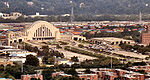
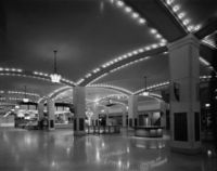
, and stops at Cincinnati Union Terminal. Most of the Union Terminal has now been turned into the Cincinnati Museum Center at Union Terminal
Cincinnati Museum Center at Union Terminal
The Cincinnati Museum Center at Union Terminal, originally Cincinnati Union Terminal, is a passenger railroad station in the Queensgate neighborhood of Cincinnati, Ohio, United States...
, with the Amtrak train station located in the same building. After leaving Cincinnati, the train crosses into Kentucky where it follows the Ohio River
Ohio River
The Ohio River is the largest tributary, by volume, of the Mississippi River. At the confluence, the Ohio is even bigger than the Mississippi and, thus, is hydrologically the main stream of the whole river system, including the Allegheny River further upstream...
on the southern border of Ohio to Ashland, Kentucky
Ashland, Kentucky
Ashland, formerly known as Poage Settlement, is a city in Boyd County, Kentucky, United States, nestled along the banks of the Ohio River. The population was 21,981 at the 2000 census. Ashland is a part of the Huntington-Ashland, WV-KY-OH, Metropolitan Statistical Area . As of the 2000 census, the...
.
Amtrak Capitol Limited (Chicago - Cleveland - Pittsburgh - Washington DC)
- ToledoToledo, OhioToledo is the fourth most populous city in the U.S. state of Ohio and is the county seat of Lucas County. Toledo is in northwest Ohio, on the western end of Lake Erie, and borders the State of Michigan...
(TOL) - SanduskySandusky, OhioSandusky is a city in the U.S. state of Ohio and the county seat of Erie County. It is located in northern Ohio and is situated on the shores of Lake Erie, almost exactly half-way between Toledo to the west and Cleveland to the east....
(SKY) - ElyriaElyria, Ohio-Community:Elyria has an extensive, although financially burdened, community food pantry and "Hot Meals" program administered through the Second Harvest Food Bank and several churches Elyria is served by Elyria Memorial Hospital.-Recreation and parks:...
(ELY) - ClevelandCleveland, OhioCleveland is a city in the U.S. state of Ohio and is the county seat of Cuyahoga County, the most populous county in the state. The city is located in northeastern Ohio on the southern shore of Lake Erie, approximately west of the Pennsylvania border...
(CLE) - AllianceAlliance, OhioAlliance is a city in Stark and Mahoning counties in the U.S. state of Ohio. The population was 22,322 at the 2010 census. Alliance's nickname is "The Carnation City", and the city is home to the University of Mount Union....
(ALC)
Amtrak Lake Shore Limited (Chicago - Cleveland - Albany - Boston/New York City)
- BryanBryan, OhioAs of the census of 2000, there were 8,333 people, 3,528 households, and 2,155 families residing in the city. The population density was 1,821.7 people per square mile . There were 3,733 housing units at an average density of 816.1 per square mile...
(BYN) - ToledoToledo, OhioToledo is the fourth most populous city in the U.S. state of Ohio and is the county seat of Lucas County. Toledo is in northwest Ohio, on the western end of Lake Erie, and borders the State of Michigan...
(TOL) - SanduskySandusky, OhioSandusky is a city in the U.S. state of Ohio and the county seat of Erie County. It is located in northern Ohio and is situated on the shores of Lake Erie, almost exactly half-way between Toledo to the west and Cleveland to the east....
(SKY) - ElyriaElyria, Ohio-Community:Elyria has an extensive, although financially burdened, community food pantry and "Hot Meals" program administered through the Second Harvest Food Bank and several churches Elyria is served by Elyria Memorial Hospital.-Recreation and parks:...
(ELY) - ClevelandCleveland, OhioCleveland is a city in the U.S. state of Ohio and is the county seat of Cuyahoga County, the most populous county in the state. The city is located in northeastern Ohio on the southern shore of Lake Erie, approximately west of the Pennsylvania border...
(CLE)
Rail Mass Transit
Cleveland, OhioCleveland, Ohio
Cleveland is a city in the U.S. state of Ohio and is the county seat of Cuyahoga County, the most populous county in the state. The city is located in northeastern Ohio on the southern shore of Lake Erie, approximately west of the Pennsylvania border...
has two standard gauge
Standard gauge
The standard gauge is a widely-used track gauge . Approximately 60% of the world's existing railway lines are built to this gauge...
RTA Rapid Transit
RTA Rapid Transit
RTA Rapid Transit is a rapid transit and light rail system in Cleveland and Cuyahoga County owned by the Greater Cleveland Regional Transit Authority...
rail systems,
one for heavy-rail and one for three light-rail "streetcar" lines:
Heavy-Rail stations
- Red Line (Cleveland)Red Line (Cleveland)The Red Line is a rapid transit line of the RTA Rapid Transit in Cleveland, Ohio, running from Cleveland Hopkins International Airport northeast to Tower City in downtown Cleveland, then east and northeast to Windermere...
: - AirportCleveland Hopkins International Airport (RTA Rapid Transit station)Cleveland Hopkins International Airport is a station on the RTA Red Line in Cleveland, Ohio, USA. It is the western terminus of the Red Line and is located off the lower level below the middle of the baggage claim level of Cleveland Hopkins International Airport.-History:The station opened on...
- BrookparkBrookpark (RTA Rapid Transit station)Brookpark is a station on the RTA Red Line in Cleveland, Ohio, USA. It is located along Brookpark Road west of the intersection of Engle Road ....
(Engle Rd.) - PuritasPuritas (RTA Rapid Transit station)Puritas is a station on the RTA Red Line in Cleveland, Ohio, USA. It is located at off West 150th Street just north of Interstate 71. The entrance to the station parking lot is off exit/entrance ramp to Interstate 71...
& West 150th. St. - West ParkWest Park (RTA Rapid Transit station)West Park is a station on the RTA Red Line in Cleveland, Ohio, USA. It is located off Lorain Avenue just west of West 143rd Street.The station includes a large parking lot accessible from Lorain Avenue. The access road has been named Lloyd Peterson Lane. A station lobby building is located on...
(Lorain Ave.) - TriskettTriskett (RTA Rapid Transit station)Triskett is a station on the RTA Red Line in Cleveland, Ohio, USA. It is located off Triskett Road between West 139th Street and Berea Road....
(West 140th. St.) - West 117th–MadisonWest 117th–Madison (RTA Rapid Transit station)West 117th–Madison Avenue Highland Square is a station on the RTA Red Line in Cleveland, Ohio, USA. It is located on the border between Cleveland and Lakewood....
- Detroit & West Blvd.–CudellWest Boulevard–Cudell (RTA Rapid Transit station)West Boulevard-Cudell is a station on the RTA Red Line in Cleveland, Ohio, USA. The station is located on the north side of Detroit Avenue at the intersection with West Boulevard in Cleveland's Cudell–West Boulevard neighborhood....
- West 65th–LorainWest 65th–Lorain (RTA Rapid Transit station)West 65th–Lorain is a station on the RTA Red Line in Cleveland, Ohio, USA. It is located between Lorain Avenue and Madison Avenue at West 61st Street....
(Madison) - Lorain & West 25th–Ohio CityWest 25th–Ohio City (RTA Rapid Transit station)West 25th-Ohio City is a station on the RTA Red Line in the Ohio City neighborhood of Cleveland, Ohio, USA. It is located at the intersection of West 24th Street, Abbey Avenue and Lorain Avenue , diagonally across Lorain Avenue from the West Side Market.-Notable places nearby:* Great Lakes Brewing...
- (SEE SHARED STATIONS BELOW.)
- East 79thEast 79th (RTA Red Line Rapid Transit station)East 79th is a station on the RTA Red Line in Cleveland, Ohio, USA. It is located on the west side of East 79th Street between Woodland Avenue and Grand Avenue. The entrance is on the east side of East 79th Street....
(near) - East 105th–QuincyEast 105th–Quincy (RTA Rapid Transit station)East 105th–Quincy is a station on the RTA Red Line in Cleveland, Ohio, USA. It is located in the Fairfax neighborhood, on the city's east side. The station has a small entrance is on the north side of Quincy Avenue.-Notable places nearby:*...
- Cedar & University CircleUniversity Circle (RTA Rapid Transit station)University Circle is a station on the RTA Red Line in Cleveland, Ohio, USA. The station is located in University Circle at the foot of Cedar Hill along Cedar Glen Parkway . It includes entrances on both sides of Cedar, with bus loading lanes along Cedar on each side...
- Euclid–East 120thEuclid–East 120th (RTA Rapid Transit station)Euclid–East 120th is a station on the RTA Red Line in Cleveland, Ohio, USA. It is located along Euclid Avenue at the corner of Coltman Road, near the western end of Lake View Cemetery....
- SuperiorSuperior (RTA Rapid Transit station)Superior is a station on the RTA Red Line in Cleveland, Ohio, USA. It is located on Superior Avenue at the intersection of Emily Street, approximately 1½ blocks west of Euclid Avenue...
(near) - Stokes/WindermereLouis Stokes Station at WindermereLouis Stokes Station at Windermere is a rapid transit station on the RTA Red Line in East Cleveland, Ohio, USA. It is located on the northwest side of Euclid Avenue between Bryn Mawr and Doan Roads...
(Euclid Ave.)
Shared stations
- Red heavy-Red Line (Cleveland)The Red Line is a rapid transit line of the RTA Rapid Transit in Cleveland, Ohio, running from Cleveland Hopkins International Airport northeast to Tower City in downtown Cleveland, then east and northeast to Windermere...
, Green, Blue, & Lakefront light-rail LinesBlue and Green Lines (Cleveland)The Blue Line, Green Line, and Waterfront Line are the interurban/light rail component of the RTA Rapid Transit, a rapid transit rail system in greater Cleveland and Shaker Heights, Cuyahoga County, Ohio...
: - Terminal Tower CityTower City (RTA Rapid Transit station)Tower City Station is a rapid transit station in Cleveland, Ohio, USA. It is the central station on the RTA Red Line and the major station on the RTA Green and Blue Lines. The station is located directly beneath Prospect Avenue in the middle of the Tower City Center shopping mall...
(Cleveland Union Terminal at Cleveland Public Square)
- Red heavy-Red Line (Cleveland)The Red Line is a rapid transit line of the RTA Rapid Transit in Cleveland, Ohio, running from Cleveland Hopkins International Airport northeast to Tower City in downtown Cleveland, then east and northeast to Windermere...
, Green, Blue, & light-rail LinesBlue and Green Lines (Cleveland)The Blue Line, Green Line, and Waterfront Line are the interurban/light rail component of the RTA Rapid Transit, a rapid transit rail system in greater Cleveland and Shaker Heights, Cuyahoga County, Ohio...
: - Broadway & East 34th–Campus (Cuyahoga Community CollegeCuyahoga Community CollegeCuyahoga Community College is a two-year college in Cuyahoga County, Ohio. Founded in 1962, Cuyahoga Community College is the oldest, and largest community college in Ohio with a Fall 2009 enrollment of 31,024. * http://www.tri-c.edu/news/Pages/20100823a.aspxIn August of 2010, the college reported...
downtown) - East 55thEast 55th (RTA Rapid Transit station)East 55th is a station on the RTA Red, Green and Blue Lines in Cleveland, Ohio, USA. The station entrance is located on the west side of East 55th Street just north of the intersection with Bower Avenue and the eastern terminus of Interstate 490....
(near)
- Blue and Green Lines (Cleveland)Blue and Green Lines (Cleveland)The Blue Line, Green Line, and Waterfront Line are the interurban/light rail component of the RTA Rapid Transit, a rapid transit rail system in greater Cleveland and Shaker Heights, Cuyahoga County, Ohio...
light-rail: - East 79thEast 79th (RTA Blue and Green Line Rapid Transit station)East 79th is a station on the RTA Blue and Green Lines in Cleveland, Ohio, USA. It is located on East 79th Street south of Holton Avenue.The station bears the same name as the East 79th station on the Red Line...
(near) - WoodhillWoodhill (RTA Rapid Transit station)Woodhill is a station on the RTA Blue and Green Lines in Cleveland, Ohio, USA. It is located at the intersection of Woodhill Road, Buckeye Road and Shaker Boulevard....
- East 116thEast 116th (RTA Rapid Transit station)East 116th is a station on the RTA Blue and Green Lines in Cleveland, Ohio, USA. It is located at the intersection of East 116th Street and Shaker Boulevard....
- Shaker SquareShaker Square (RTA Rapid Transit station)Shaker Square Station is a station on the RTA Blue and Green Lines in Cleveland, Ohio, USA. It is first station west of the junction of the Blue and Green Lines and thus serves as a transfer point between the two lines....
Light-rail stations
- Green/Shaker lineBlue and Green Lines (Cleveland)The Blue Line, Green Line, and Waterfront Line are the interurban/light rail component of the RTA Rapid Transit, a rapid transit rail system in greater Cleveland and Shaker Heights, Cuyahoga County, Ohio...
: - SEE SHARED STATIONS ABOVE.
- CoventryCoventry (RTA Rapid Transit station)Coventry is a station stop on the RTA Green Line in Cleveland, Ohio, USA. It is located at the intersection of Coventry Road and Shaker Boulevard on the border between Cleveland and Shaker Heights....
- SouthingtonSouthington (RTA Green Line Rapid Transit station)Southington is a station stop on the RTA Green Line in Cleveland, Ohio, USA. It is located at the intersection of Southington Road and Shaker Boulevard in Shaker Heights.The station has the same name as Southington station on the Blue Line...
- South ParkSouth Park (RTA Rapid Transit station)South Park is a station stop on the RTA Green Line in Cleveland, Ohio, USA. It is located at the intersection of South Park Boulevard and Shaker Boulevard in Shaker Heights....
- LeeLee (RTA Green Line Rapid Transit station)Lee is a station stop on the RTA Green Line in Cleveland, Ohio, USA. It is located at the intersection of Southington Road and Shaker Boulevard in Shaker Heights.The station has the same name as Lee station on the Blue Line...
- AttleboroAttleboro (RTA Rapid Transit station)Attleboro is a station stop on the RTA Green Line in Cleveland, Ohio, USA. It is located at the intersection of Southington Road and Shaker Boulevard in Shaker Heights....
- EatonEaton (RTA Rapid Transit station)Eaton is a station stop on the RTA light rail Green Line in Cleveland, Ohio, USA. It is located at the intersection of Eaton Road, Torrington Road and Shaker Boulevard in Shaker Heights....
- CourtlandCourtland (RTA Rapid Transit station)Courtland is a station stop on the RTA light rail Green Line in Cleveland, Ohio, USA. It is located at the intersection of Courtland Boulevard, Manchester Road, Montgomery Road and Shaker Boulevard in Shaker Heights....
- WarrensvilleWarrensville (RTA Green Line Rapid Transit station)Warrensville is a station on the Green Line of the RTA Rapid Transit in Cleveland, Ohio, USA. It is located in the median of Shaker Boulevard on the west side of Warrensville Center Road in Shaker Heights....
- BelvoirBelvoir (RTA Rapid Transit station)Belvoir is a station stop on the light rail Green Line of the RTA Rapid Transit in Cleveland, Ohio, USA. It is located in Shaker Heights in the wide landscaped median of Shaker Boulevard at the intersection of Belvoir Road on the north and Belvoir Oval on the south...
- West GreenWest Green (RTA Rapid Transit station)West Green is a station stop on the Green Line of the RTA Rapid Transit in Cleveland, Ohio, USA. It is located at the western end of the parking lot for the Green Road station....
- GreenGreen (RTA Rapid Transit station)Green Road Station is a station on the Green Line of the RTA Rapid Transit in Cleveland, Ohio, USA. It is the eastern terminus of the Green Line....
- Blue/VanAken-Warrensville lineBlue and Green Lines (Cleveland)The Blue Line, Green Line, and Waterfront Line are the interurban/light rail component of the RTA Rapid Transit, a rapid transit rail system in greater Cleveland and Shaker Heights, Cuyahoga County, Ohio...
: - SEE SHARED STATIONS ABOVE.
- DrexmoreDrexmore (RTA Rapid Transit station)Drexmore is a station stop on the RTA Blue Line in Cleveland, Ohio, USA. It is located at the intersection of Drexmore Road and Van Aken Boulevard....
- South WoodlandSouth Woodland (RTA Rapid Transit station)South Woodland is a station stop on the RTA Blue Line in Cleveland, Ohio, USA. It is located at the intersection of South Woodland Road and Van Aken Boulevard on the border between Cleveland and Shaker Heights....
- SouthingtonSouthington (RTA Blue Line Rapid Transit station)Southington is a station stop on the RTA Blue Line in Cleveland, Ohio, USA. It is located at the intersection of Southington Road and Van Aken Boulevard in Shaker Heights.The station has the same name as Southington station on the Green Line...
- OnawayOnaway (RTA Rapid Transit station)Onaway is a station stop on the RTA Blue Line in Cleveland, Ohio, USA. It is located at the intersection of Onaway Road and Van Aken Boulevard in Shaker Heights....
- AshbyAshby (RTA Rapid Transit station)Ashby is a station stop on the RTA Blue Line in Cleveland, Ohio, USA. It is located at the intersection of Ashby Road and Van Aken Boulevard in Shaker Heights....
- LeeLee (RTA Blue Line Rapid Transit station)Lee is a station on the RTA Blue Line in Cleveland, Ohio, USA. It is located at the intersection of Lee Road and Van Aken Boulevard in Shaker Heights.The station is located in a cut within the median of Van Aken Boulevard west of Lee Road...
- AvalonAvalon (RTA Rapid Transit station)Avalon is a station stop on the RTA Blue Line in Cleveland, Ohio, USA. It is located at the intersection of Avalon Road and Van Aken Boulevard in Shaker Heights....
- KenmoreKenmore (RTA Rapid Transit station)Kenmore is a station stop on the RTA Blue Line in Cleveland, Ohio, USA. It is located at the intersection of Kenmore Road, Glencairn Road, Ingleside Road and Van Aken Boulevard in Shaker Heights....
- LynnfieldLynnfield (RTA Rapid Transit station)Lynnfield is a station stop on the RTA Blue Line in Cleveland, Ohio, USA. It is located at the intersection of Lynnfield Road, Parkland Drive, Norwood Road and Van Aken Boulevard in Shaker Heights....
- FarnsleighFarnsleigh (RTA Rapid Transit station)Farnsleigh is a station stop on the RTA Blue Line in Cleveland, Ohio, USA. It is located at the intersection of Farnsleigh Road and Van Aken Boulevard in Shaker Heights....
- WarrensvilleWarrensville (RTA Blue Line Rapid Transit station)Warrensville is a station stop on the RTA light rail Blue Line in Cleveland, Ohio, USA. It is the eastern terminus of the Blue Line.It is located at the median of Van Aken Boulevard near the intersection of Warrensville Center Road, Chagrin Boulevard Warrensville is a station stop on the RTA light...
- Waterfront Line:
- South HarborSouth Harbor (RTA Rapid Transit station)South Harbor is a station on the RTA Waterfront Line portion of the Blue and Green Lines in Cleveland, Ohio, USA. It is the northern termius of the Waterfront Line and the terminus of the Blue and Green Lines....
(Cleveland Memorial ShorewayCleveland Memorial ShorewayThe Cleveland Memorial Shoreway is a limited-access freeway in Cleveland, Ohio. It closely follows the shore of Lake Erie and connects the east and west sides of Cleveland via the Main Avenue Bridge. The Shoreway carries State Route 2 along its length, and also carries U.S. 6, U.S. 20 and I-90...
parking lot) - North CoastNorth Coast (RTA Rapid Transit station)North Coast Station is a station on the RTA Waterfront Line portion of the Blue and Green Lines in Cleveland, Ohio, USA. The station is located west of East 9th Street, south of the Cleveland Memorial Shoreway, and north of the CSX railroad tracks. Entrance to the station is from the west side of...
(East 9th. St. between Cleveland Memorial ShorewayCleveland Memorial ShorewayThe Cleveland Memorial Shoreway is a limited-access freeway in Cleveland, Ohio. It closely follows the shore of Lake Erie and connects the east and west sides of Cleveland via the Main Avenue Bridge. The Shoreway carries State Route 2 along its length, and also carries U.S. 6, U.S. 20 and I-90...
& Lakeside Ave.) - AmtrakCleveland Lakefront StationCleveland Lakefront Station is Amtrak's station in Cleveland, Ohio. The station was built in 1976 to provide service to the Lake Shore Limited route, which was reinstated by Amtrak via Cleveland and Toledo in 1975...
- West 3rdWest 3rd (RTA Rapid Transit station)West 3rd Street Station at Cleveland Browns Stadium is a station on the RTA Waterfront Line portion of the Blue and Green Lines in Cleveland, Ohio, USA. The station is located on the east side of West 3rd Street and south of the westboard exit ramp of the Cleveland Memorial Shoreway...
(between Cleveland Memorial ShorewayCleveland Memorial ShorewayThe Cleveland Memorial Shoreway is a limited-access freeway in Cleveland, Ohio. It closely follows the shore of Lake Erie and connects the east and west sides of Cleveland via the Main Avenue Bridge. The Shoreway carries State Route 2 along its length, and also carries U.S. 6, U.S. 20 and I-90...
& Lakeside Ave.) - Flats East BankFlats East Bank (RTA Rapid Transit station)Flats East Bank is a station on the RTA Waterfront Line portion of the Blue and Green Lines in Cleveland, Ohio, USA. The station is located along West 10th Street just southeast of its intersection with Main Avenue in The Flats district.-History:...
- Settlers LandingSettlers Landing (RTA Rapid Transit station)Settlers Landing Station is a station on the RTA Waterfront Line portion of the Blue and Green Lines in Cleveland, Ohio, USA. The station is located just south of the intersection of West Superior Avenue and Old River Road....
- SEE SHARED Red, Green, Blue, & Lakefront STATIONS ABOVE.
CAUTION:
Both Red heavy-rail line, and Blue & Green light-rail lines have stations called "East 79th.",
they are two different stations geographically apart on East 79th. St.
Similarly, the Blue & Green lines have Southington, Lee, and Warrensville stations which are pairs of different stations geographically apart on their respective street names.
Scenic trains
- Ashtabula, Carson & Jefferson Scenic Railroad - Jefferson, OhioJefferson, OhioJefferson is a village in Ashtabula County, Ohio, United States. The population was 3,572 at the 2000 census. It is the county seat of Ashtabula County. Modern-day Jefferson sports the world's only perambulator museum and a historical complex including several restored 18th century buildings....
- Jefferson
- Buckeye Central Scenic Railroad - Hebron, OhioHebron, OhioHebron is a village in Licking County, Ohio, United States. The population was 2,034 at the 2000 census.-Geography:Hebron is located at .According to the United States Census Bureau, the village has a total area of , all of it land....
(defunct; see ZWSR) - Byesville Scenic RailwayByesville Scenic RailwayByesville Scenic Railway is a tourist railroad located in Byesville, Ohio. The railway is a non-profit group dedicated to preserving the local coal mining and railroad history in Guernsey County, Ohio. The railroad runs on track that was originally known as the Cleveland & Marietta Railroad and...
- Byesville, OhioByesville, OhioByesville is a village in Guernsey County, Ohio, United States, along Wills Creek. The population was 2,574 as of the 2000 census.-Geography:Byesville is located at .... - Byesville Station
- N Cabin (C&M Crossing)
- Connotton Valley Railway - Bedford, OhioBedford, OhioBedford is a city in Cuyahoga County, Ohio, United States. The population was 13,074 at the 2010 census. It is an eastern suburb of Cleveland.-Geography:Bedford is located at ....
- Bedford Depot
- Cuyahoga Valley Scenic RailroadCuyahoga Valley Scenic RailroadCuyahoga Valley Scenic Railroad is a Class III railroad and steam-powered excursion trips through Peninsula, Ohio in the Cuyahoga Valley, primarily through the scenic Cuyahoga Valley National Park.-History:...
- Peninsula, OhioPeninsula, OhioPeninsula is a village in Summit County, Ohio, United States. The population was 602 at the 2000 census. It is part of the Akron Metropolitan Statistical Area.... - Rockside Station
- Canal Visitor Center
- Brecksville Station
- Boston Mill Station
- Peninsula Depot
- Indigo Lake
- Botzum (Indian Mound) Station
- Akron Northside Station
- Howe Meadow
- Canton Lincoln Highway Station
- Hocking Valley Scenic Railway - Nelsonville, OhioNelsonville, OhioNelsonville is a city in northwestern Athens County, Ohio, United States. The population was 5,230 at the 2000 census. Hocking College is located in Nelsonville.-Geography:...
- Nelsonville Depot
- Haydenville
- Robbins Crossing
- Logan
- Lebanon Mason Monroe RailroadLebanon Mason Monroe RailroadThe Lebanon Mason Monroe Railroad is located in historic downtown Lebanon, Ohio, between Dayton and Cincinnati. The attraction features nostalgic train rides that are usually themed, such as the Easter Bunny Express, North Pole Express, and rides with favorite children's characters including Thomas...
- Lebanon, OhioLebanon, OhioThe population at the 2010 census was 20,033. As of the census of 2000, there were 16,962 people residing in the city. The population density was 1,440.6 people per square mile . There were 6,218 housing units at an average density of 528.1 per square mile... - Lebanon Station
- Southwest Golf Ranch
- Schappacher Farms
- Lorain & West Virginia Railway - Wellington, OhioWellington, OhioWellington is a village in Lorain County, Ohio, United States. The population was 4,511 at the 2000 census.-History:Wellington was settled in 1818 by Ephraim Wilcox, Charles Sweet, William T. Welling, John Clifford, and Joseph Wilson from the states of Massachusetts and New York...
- Minerva Scenic Railway - Minerva, OhioMinerva, OhioMinerva is a village in Carroll, Columbiana, and Stark counties in the U.S. state of Ohio. The population was 3,934 at the 2000 census.The Carroll and Stark County portions of Minerva are part of the Canton–Massillon Metropolitan Statistical Area, while the Columbiana County portion is part...
- Minerva
- Toledo, Lake Erie and Western RailwayToledo, Lake Erie and Western RailwayThe Toledo, Lake Erie and Western Railway is a Class III railroad, operating on of railway, ex- Norfolk and Western Railroad, nee-Toledo, St. Louis and Western Railroad and crosses the Maumee River on a bridge. This line runs from Waterville to Grand Rapids, Ohio. Currently TLEW only operates as...
- Waterville, OhioWaterville, OhioWaterville is a village in Lucas County, Ohio, United States, along the Maumee River. The population was 4,828 at the 2000 census.-Geography:Waterville is located at .... - Waterville Station
- Zanesville & Western Scenic Railroad - Fultonham, OhioFultonham, OhioFultonham is a village in Muskingum County, Ohio, United States. The population was 151 at the 2000 census. It was named for inventor Robert Fulton.-Geography:Fultonham is located at ....
(former Buckeye Central Scenic Railroad & Glass Rock Line)
See also
- Railroad terminals of Cleveland, OhioRailroad terminals of Cleveland, OhioThe table below shows all railroad lines that have served downtown Cleveland, Ohio and what terminal they used. A red background indicates that the railroad owned a part or full share of the terminal....
- List of railway stations
- List of Union Stations