
Cincinnati Subway
Encyclopedia
The Cincinnati Subway is a set of unused tunnel
s and stations for a rapid transit
system beneath the streets of Cincinnati, Ohio
. It is recognized as the largest abandoned subway tunnel in the United States. Construction took place in the early twentieth century, but the project was not completed so it never hosted a paying customer.
The project has been described as "one of the city's biggest embarrassments," and "one of Cincinnati's biggest failures." Some argue that because rapid transit was never completed Cincinnati is smaller, forces its citizens to be automobile-dependent, has its downtown area dominated by highways and parking lots, lacks "walkable communities," motivates people to live outside of the city, and has spawned today's traffic jams. Others say it would have been abandoned anyway due to waning ridership, as was the case with the city's original streetcars
and the Mount Adams Incline
. Others have pointed to the project being a rare example of a city avoiding the sunk cost fallacy.
Proposals to complete the subway have been near continuous since its initial failure, but all attempts to use the tunnels for transit have failed thus far. Many Cincinnatians do not know subway tunnels exist under their city.
. Unexpected post-war inflation doubled the cost of construction, so the project could not be finished at the original estimated price. Despite various attempts to use the subway tunnels for mass transit, thus far all attempts have been unsuccessful. Political squabbling, The Great Depression
, World War II
, and the rise in popularity of the automobile
have all contributed to the current failure of the subway.
 From 1825 until 1920 the Miami and Erie Canal
divided Cincinnati's residential neighborhood of Over-the-Rhine
from the business district of downtown. The canal was used to transport goods and people from the Great Lakes
to the Ohio River
and subsequently the Mississippi River
via Cincinnati, until the popularity of railroads caused it to go into disuse. The canal became unprofitable by 1856 and was officially abandoned by the city in 1877. On September 27, 1884 a weekly Cincinnati magazine called The Graphic proposed that the "dead old ditch" be used to provide an unobstructed route for a subway system, with a large boulevard above.
In 1888, Cincinnati began adopting electric streetcars, which soon became the main form of public transportation. By the turn of the 20th century Cincinnati was one of the ten largest cities in the United States, and had a rate of growth and economic importance that was similar to that of New York City
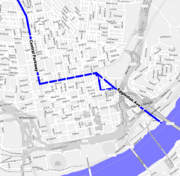
and Chicago. The slow streetcars shared the crowded streets with horse-drawn carriages, people, and collided with the first automobiles on an almost daily basis. It was not unusual for trips between downtown and the surrounding suburbs to take 45 minutes or an hour. Despite having 222 miles (357.3 km) of streetcar tracks, the city found itself in a growing traffic nightmare. In 1910, Henry Thomas Hunt
spearheaded plans for a new rapid transit system.
and Norwood
, the eastern suburbs of Oakley
and Hyde Park
, and then returned into downtown.
In 1916 City Council authorized a bond issue of $6,000,000 with an interest rate of 4.25 percent, and then sent Rapid Transit to the public polls. On April 17, 1917, Cincinnati citizens voted in favor of using the bond for a Rapid Transit system, 30,165-14,286. However, just 11 days earlier, the United States entered World War I, so construction was halted because no capital issues of bonds were permitted during the war.
 When the war concluded in 1919 the cost of construction had doubled, increasing the original price to complete the loop to $12,000,000 or $13,000,000. Regardless, the city began work on January 28, 1920, and planned to raise the money to complete the loop later. When bonds ran out in 1927 construction ended with seven miles (11 km) of subway dug or graded, but no track had been laid.
New estimates to complete the loop ranged from an additional $6,000,000 to $12,000,000. The boulevard that ran on top of the subway, called "Central Parkway," officially opened to traffic on October 1, 1928, and was followed by a week of public celebration.
Once it became apparent that the original Rapid Transit plan had failed, political squabbling in City Hall stalled any new progress, and any hope of raising the money to complete the subway was further delayed with the stock market crash of 1929
. Though few citizens owned automobiles when Mayor Hunt first planned Rapid Transit in 1910, their increasing popularity and convenience helped fuel critics' arguments against a subway system. They began referring to the project as "Cincinnati's White Elephant
."
However, in 1939 the tunnels were researched for possible automobile traffic, but were found to be unsuitable for that use. In 1940 the city sought the advice of several experts to settle once and for all the fate of the subway. The report recommended placing all streetcar and trolley transportation underground (i.e. a subway), but Cincinnati already had too many other expensive public projects underway. The plan was put on hold yet again when the United States entered World War II in 1941.
During World War II, the city was focused on war-time rationing, so completing the subway was not a high priority. The tunnels were suggested as possible air raid shelters, but the idea was never implemented. The tunnels were also suggested for underground storage of commercial and military supplies, then as a pathway to bring freight into the heart of the city, but both ideas were shot down because they'd delay bringing mass transit to Cincinnati. After the war ended the City Planning Commission decided to not include the subway in its plans. Instead, the Commission would use the loop's right-of-way as pathways for Interstate 75
and the Norwood Lateral.
In the 1950s a massive 52-inch water main was laid in the north-bound tunnel to save $300,000 in construction costs. According to the engineering firm Parsons Brinckerhoff
, a redundant water main was installed during the construction of Fort Washington Way
so the water main in the subway could easily be removed. There is also an escape clause in Ordinance No. 154-1956 that states, "in the event said section of the rapid transit subway is, at some future date, needed for rapid transit purposes, the Water Works shall remove said main at its sole cost."
The subway bonds were finally paid off in 1966 at a total price of $13,019,982.45. Around that time Meier's Wine Cellars Inc. wanted to use the subway tunnels to store wine, as well as install a bottling operation to draw tourists, but it fell through due to a lack of proper building codes. In the 1970s Nick Clooney
wanted to turn parts of the tunnel into an underground mall, as well as a night club, but that fell through early on due to insurance issues. In the 1980s the city pitched the tunnels to Hollywood filmmakers as an ideal location to shoot subway scenes. In particular, the location was presented to the makers of Batman Forever
, but as of 2008 the tunnels have not been used in any feature films.
In 2002 the subway tunnels were proposed as a route for a regional light rail
system that would cost $2.6 billion and take thirty years to build. The tunnels were favored because they were in an ideal location, they could easily be used to connect the east side and the west sides of Cincinnati, and they would've saved the city at least $100,000,000 in construction costs at the time. The light rail plan, called MetroMoves
, proposed a tax levy that would've raised sales tax in Hamilton county by a half-cent. The plan was voted down by more than a 2-to-1 ratio.
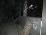
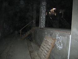
Recently, the uncompleted subway tunnels and stations have been described as "strikingly well preserved" and "in good shape." This is partially credited to the original construction quality, and partially because Cincinnati must use tax dollars to maintain the tunnel because Central Parkway is situated on top of it.
As of 2008 it would cost $2.6 million over five years to maintain the tunnels as they currently are, $19 million to fill the tunnels with dirt, and $100.5 million to revive the tunnels for modern subway use. Relocating the 52 inches (1.3 m) water main would cost $14 million.
 Seven stations were completed along Central Parkway. Underground locations are at Race Street, Liberty Street, Linn Street, and Brighton Place. Above-ground locations were at Marshall Street, Ludlow Avenue, and Clifton Avenue. The underground stations remain intact, but the above-ground stations were demolished when I-75 was built in the 1960s.
The first station was the Race Street Station, which was to serve as the main hub. It was configured with the platform in the center, with the subway running along the north and south side. Next was Liberty Street, which was a through-station. It was a simple design with a platform on each side of the track. Third was Linn Street, a through station. Laid out similarly to Liberty Street, this station has been sealed up, and can be easily missed when walking through. Fourth was Brighton Place, another through-station. Marshall Street was the most grand of the above-ground stations, located to the west near the Mill Creek Valley. Ludlow Avenue Station was constructed under the south side of the Ludlow Viaduct and was also a through-station. The last to be completed was Clifton Avenue, which was located where the street passes under present day I-75. There were additional stations in the plan; however, funding ran out as the project reached Norwood
.
There were many details of the unfinished subway system, such as a provision for a station at Mohawk Corner, where the wall has been set back. At Walnut Street the lines begin to curve south to go into downtown, but they are stopped short by a bricked up wall. The subway tube is double tracked throughout its entire length, with a concrete wall separating the two tracks. Openings in the wall enable persons to step from one track to another. The tunnels are well ventilated and provide much light until Liberty Street is reached.
Both subway tours begin at Media Bridges, located at Race Street and Central Parkway, downtown. Space is limited and tickets sell out quickly.
's Cambridge-Dorchester Tunnel (Red Line
). A similar construction can also be found at the Newark City Subway using the former bed of the Morris Canal
, the similarly abandoned Rochester Subway
, which used the bed of the Erie Canal
, as well as Calgary
's not yet used C-Train
tunnels, underneath 8th Ave on Downtown Calgary
, Alberta
, Canada
Tunnel
A tunnel is an underground passageway, completely enclosed except for openings for egress, commonly at each end.A tunnel may be for foot or vehicular road traffic, for rail traffic, or for a canal. Some tunnels are aqueducts to supply water for consumption or for hydroelectric stations or are sewers...
s and stations for a rapid transit
Rapid transit
A rapid transit, underground, subway, elevated railway, metro or metropolitan railway system is an electric passenger railway in an urban area with a high capacity and frequency, and grade separation from other traffic. Rapid transit systems are typically located either in underground tunnels or on...
system beneath the streets of Cincinnati, Ohio
Ohio
Ohio is a Midwestern state in the United States. The 34th largest state by area in the U.S.,it is the 7th‑most populous with over 11.5 million residents, containing several major American cities and seven metropolitan areas with populations of 500,000 or more.The state's capital is Columbus...
. It is recognized as the largest abandoned subway tunnel in the United States. Construction took place in the early twentieth century, but the project was not completed so it never hosted a paying customer.
The project has been described as "one of the city's biggest embarrassments," and "one of Cincinnati's biggest failures." Some argue that because rapid transit was never completed Cincinnati is smaller, forces its citizens to be automobile-dependent, has its downtown area dominated by highways and parking lots, lacks "walkable communities," motivates people to live outside of the city, and has spawned today's traffic jams. Others say it would have been abandoned anyway due to waning ridership, as was the case with the city's original streetcars
Cincinnati streetcars
Cincinnati streetcars were the main form of public transportation in Cincinnati, Ohio at the turn of the twentieth century. The original streetcar system was dismantled in 1951....
and the Mount Adams Incline
Mount Adams Incline
The Mount Adams Incline was a funicular, or inclined plane, located in the Cincinnati neighborhood of Mount Adams. Completed in 1872, it was the longest-running of the city's five inclines, closing in 1948. It has since been demolished.-External links:**...
. Others have pointed to the project being a rare example of a city avoiding the sunk cost fallacy.
Proposals to complete the subway have been near continuous since its initial failure, but all attempts to use the tunnels for transit have failed thus far. Many Cincinnatians do not know subway tunnels exist under their city.
History
Rapid transit was seen as the solution for downtown congestion during the first quarter of the 20th century. Six million dollars were allocated for the project, but construction was delayed due to World War IWorld War I
World War I , which was predominantly called the World War or the Great War from its occurrence until 1939, and the First World War or World War I thereafter, was a major war centred in Europe that began on 28 July 1914 and lasted until 11 November 1918...
. Unexpected post-war inflation doubled the cost of construction, so the project could not be finished at the original estimated price. Despite various attempts to use the subway tunnels for mass transit, thus far all attempts have been unsuccessful. Political squabbling, The Great Depression
Great Depression
The Great Depression was a severe worldwide economic depression in the decade preceding World War II. The timing of the Great Depression varied across nations, but in most countries it started in about 1929 and lasted until the late 1930s or early 1940s...
, World War II
World War II
World War II, or the Second World War , was a global conflict lasting from 1939 to 1945, involving most of the world's nations—including all of the great powers—eventually forming two opposing military alliances: the Allies and the Axis...
, and the rise in popularity of the automobile
Automobile
An automobile, autocar, motor car or car is a wheeled motor vehicle used for transporting passengers, which also carries its own engine or motor...
have all contributed to the current failure of the subway.
The idea
Miami and Erie Canal
The Miami and Erie Canal was a canal that connected the Ohio River in Cincinnati, Ohio with Lake Erie in Toledo, Ohio. Construction on the canal began in 1825 and was completed in 1845. It consisted of 19 aqueducts, three guard locks, and 103 canal locks. Each lock measured by and they...
divided Cincinnati's residential neighborhood of Over-the-Rhine
Over-the-Rhine
Over-the-Rhine, sometimes shortened to OTR, is a neighborhood in Cincinnati, Ohio. It is believed to be the largest, most intact urban historic district in the United States. Over-the-Rhine was added to the National Register of Historic Places in 1983 with 943 contributing buildings...
from the business district of downtown. The canal was used to transport goods and people from the Great Lakes
Great Lakes
The Great Lakes are a collection of freshwater lakes located in northeastern North America, on the Canada – United States border. Consisting of Lakes Superior, Michigan, Huron, Erie, and Ontario, they form the largest group of freshwater lakes on Earth by total surface, coming in second by volume...
to the Ohio River
Ohio River
The Ohio River is the largest tributary, by volume, of the Mississippi River. At the confluence, the Ohio is even bigger than the Mississippi and, thus, is hydrologically the main stream of the whole river system, including the Allegheny River further upstream...
and subsequently the Mississippi River
Mississippi River
The Mississippi River is the largest river system in North America. Flowing entirely in the United States, this river rises in western Minnesota and meanders slowly southwards for to the Mississippi River Delta at the Gulf of Mexico. With its many tributaries, the Mississippi's watershed drains...
via Cincinnati, until the popularity of railroads caused it to go into disuse. The canal became unprofitable by 1856 and was officially abandoned by the city in 1877. On September 27, 1884 a weekly Cincinnati magazine called The Graphic proposed that the "dead old ditch" be used to provide an unobstructed route for a subway system, with a large boulevard above.
In 1888, Cincinnati began adopting electric streetcars, which soon became the main form of public transportation. By the turn of the 20th century Cincinnati was one of the ten largest cities in the United States, and had a rate of growth and economic importance that was similar to that of New York City
New York City
New York is the most populous city in the United States and the center of the New York Metropolitan Area, one of the most populous metropolitan areas in the world. New York exerts a significant impact upon global commerce, finance, media, art, fashion, research, technology, education, and...
and Chicago. The slow streetcars shared the crowded streets with horse-drawn carriages, people, and collided with the first automobiles on an almost daily basis. It was not unusual for trips between downtown and the surrounding suburbs to take 45 minutes or an hour. Despite having 222 miles (357.3 km) of streetcar tracks, the city found itself in a growing traffic nightmare. In 1910, Henry Thomas Hunt
Henry Thomas Hunt
Henry Thomas Hunt was the reform-minded mayor of Cincinnati, Ohio from 1912 to 1913. Hunt, 33 years old when he took office, quickly became known as the Boy Mayor...
spearheaded plans for a new rapid transit system.
Planning
The next year City Council convinced the Ohio State Legislature to lease the city's portion of the canal for use as a boulevard and subway system. The city hired experts that worked on Boston's and Chicago's Rapid Transit systems to research the best possible implementation for Cincinnati's Rapid Transit system. The result were four "Schemes," or proposed routes. The chosen plan, Scheme IV, modification H, looped around the city hitting the central suburbs of St. BernardSt. Bernard, Ohio
St. Bernard is a small city in Hamilton County, Ohio, United States. The population was 4,924 at the 2000 census.-Geography:St. Bernard is located at , and along with Norwood and Elmwood Place, is an enclave surrounded by the city of Cincinnati.According to the United States Census Bureau, the...
and Norwood
Norwood, Ohio
Norwood is the second most populous city in Hamilton County, Ohio, United States. The city is an enclave of the larger city of Cincinnati. The population was 21,675 at the 2000 census. Originally settled as an early suburb of Cincinnati in the wooded countryside north of the city, the area is...
, the eastern suburbs of Oakley
Oakley, Ohio
Oakley is a middle-class neighborhood in Cincinnati, Ohio that borders Pleasant Ridge, Madisonville, and Hyde Park. Oakley's business district, called Oakley Square, lies along Madison Road. Oakley is a primary thoroughfare and a major crosstown artery in Cincinnati.In addition to Oakley Square,...
and Hyde Park
Hyde Park, Ohio
Hyde Park is a neighborhood on the east side of Cincinnati, Ohio. In 1998, the average home sales price was $248,512.Hyde Park is an eclectic neighborhood in eastern Cincinnati...
, and then returned into downtown.
In 1916 City Council authorized a bond issue of $6,000,000 with an interest rate of 4.25 percent, and then sent Rapid Transit to the public polls. On April 17, 1917, Cincinnati citizens voted in favor of using the bond for a Rapid Transit system, 30,165-14,286. However, just 11 days earlier, the United States entered World War I, so construction was halted because no capital issues of bonds were permitted during the war.
Construction and failure
New estimates to complete the loop ranged from an additional $6,000,000 to $12,000,000. The boulevard that ran on top of the subway, called "Central Parkway," officially opened to traffic on October 1, 1928, and was followed by a week of public celebration.
Once it became apparent that the original Rapid Transit plan had failed, political squabbling in City Hall stalled any new progress, and any hope of raising the money to complete the subway was further delayed with the stock market crash of 1929
Wall Street Crash of 1929
The Wall Street Crash of 1929 , also known as the Great Crash, and the Stock Market Crash of 1929, was the most devastating stock market crash in the history of the United States, taking into consideration the full extent and duration of its fallout...
. Though few citizens owned automobiles when Mayor Hunt first planned Rapid Transit in 1910, their increasing popularity and convenience helped fuel critics' arguments against a subway system. They began referring to the project as "Cincinnati's White Elephant
White elephant
A white elephant is an idiom for a valuable but burdensome possession of which its owner cannot dispose and whose cost is out of proportion to its usefulness or worth...
."
Attempts at revival
In 1936 the city commissioned the Engineers' Club of Cincinnati to produce a report on how to use the unfinished rapid transit property. The report could not find any use for the tunnels other than what they were originally designed for. Because the city's needs had changed from twenty years earlier the report suggested that the subway "should be forgotten."However, in 1939 the tunnels were researched for possible automobile traffic, but were found to be unsuitable for that use. In 1940 the city sought the advice of several experts to settle once and for all the fate of the subway. The report recommended placing all streetcar and trolley transportation underground (i.e. a subway), but Cincinnati already had too many other expensive public projects underway. The plan was put on hold yet again when the United States entered World War II in 1941.
During World War II, the city was focused on war-time rationing, so completing the subway was not a high priority. The tunnels were suggested as possible air raid shelters, but the idea was never implemented. The tunnels were also suggested for underground storage of commercial and military supplies, then as a pathway to bring freight into the heart of the city, but both ideas were shot down because they'd delay bringing mass transit to Cincinnati. After the war ended the City Planning Commission decided to not include the subway in its plans. Instead, the Commission would use the loop's right-of-way as pathways for Interstate 75
Interstate 75 in Ohio
In the U.S. state of Ohio, Interstate 75 runs from Cincinnati to Toledo by way of Dayton. I-75 enters Ohio concurrent with I-71 from Kentucky on the Brent Spence Bridge over the Ohio River and into the Bluegrass region...
and the Norwood Lateral.
In the 1950s a massive 52-inch water main was laid in the north-bound tunnel to save $300,000 in construction costs. According to the engineering firm Parsons Brinckerhoff
Parsons Brinckerhoff
Parsons Brinckerhoff is a professional services firm with 14,000 employees in 150 offices providing construction and operation management, planning, design, engineering, program management, strategic consulting, environmental and sustainability services for clients and communities in the Americas,...
, a redundant water main was installed during the construction of Fort Washington Way
Fort Washington Way
Fort Washington Way is a one-mile section of freeway in downtown Cincinnati, Ohio. Running east-west in a trench, it carries Interstate 71 and US-50, first built between 1958 and 1961. It is named for a former fort which once stood nearby....
so the water main in the subway could easily be removed. There is also an escape clause in Ordinance No. 154-1956 that states, "in the event said section of the rapid transit subway is, at some future date, needed for rapid transit purposes, the Water Works shall remove said main at its sole cost."
The subway bonds were finally paid off in 1966 at a total price of $13,019,982.45. Around that time Meier's Wine Cellars Inc. wanted to use the subway tunnels to store wine, as well as install a bottling operation to draw tourists, but it fell through due to a lack of proper building codes. In the 1970s Nick Clooney
Nick Clooney
Nicholas Joseph "Nick" Clooney is an American journalist, anchorman, and television host. He is the brother of the late singer Rosemary Clooney, and father of actor and film director George Clooney.-Early life:...
wanted to turn parts of the tunnel into an underground mall, as well as a night club, but that fell through early on due to insurance issues. In the 1980s the city pitched the tunnels to Hollywood filmmakers as an ideal location to shoot subway scenes. In particular, the location was presented to the makers of Batman Forever
Batman Forever
Batman Forever is a 1995 American superhero film directed by Joel Schumacher and produced by Tim Burton. Based on the DC Comics character Batman, the film is a sequel to Batman Returns , with Val Kilmer replacing Michael Keaton as Batman...
, but as of 2008 the tunnels have not been used in any feature films.
In 2002 the subway tunnels were proposed as a route for a regional light rail
Light rail
Light rail or light rail transit is a form of urban rail public transportation that generally has a lower capacity and lower speed than heavy rail and metro systems, but higher capacity and higher speed than traditional street-running tram systems...
system that would cost $2.6 billion and take thirty years to build. The tunnels were favored because they were in an ideal location, they could easily be used to connect the east side and the west sides of Cincinnati, and they would've saved the city at least $100,000,000 in construction costs at the time. The light rail plan, called MetroMoves
MetroMoves
MetroMoves was a 2002 proposal by the Southwest Ohio Regional Transit Authority to expand and improve public transportation in the greater Cincinnati metropolitan area. The 30-year vision included the addition of light rail lines, commuter rail lines, streetcars in the downtown area, and expanded...
, proposed a tax levy that would've raised sales tax in Hamilton county by a half-cent. The plan was voted down by more than a 2-to-1 ratio.
Recently, the uncompleted subway tunnels and stations have been described as "strikingly well preserved" and "in good shape." This is partially credited to the original construction quality, and partially because Cincinnati must use tax dollars to maintain the tunnel because Central Parkway is situated on top of it.
As of 2008 it would cost $2.6 million over five years to maintain the tunnels as they currently are, $19 million to fill the tunnels with dirt, and $100.5 million to revive the tunnels for modern subway use. Relocating the 52 inches (1.3 m) water main would cost $14 million.
Stations and route
The first station was the Race Street Station, which was to serve as the main hub. It was configured with the platform in the center, with the subway running along the north and south side. Next was Liberty Street, which was a through-station. It was a simple design with a platform on each side of the track. Third was Linn Street, a through station. Laid out similarly to Liberty Street, this station has been sealed up, and can be easily missed when walking through. Fourth was Brighton Place, another through-station. Marshall Street was the most grand of the above-ground stations, located to the west near the Mill Creek Valley. Ludlow Avenue Station was constructed under the south side of the Ludlow Viaduct and was also a through-station. The last to be completed was Clifton Avenue, which was located where the street passes under present day I-75. There were additional stations in the plan; however, funding ran out as the project reached Norwood
Norwood, Ohio
Norwood is the second most populous city in Hamilton County, Ohio, United States. The city is an enclave of the larger city of Cincinnati. The population was 21,675 at the 2000 census. Originally settled as an early suburb of Cincinnati in the wooded countryside north of the city, the area is...
.
Engineering
The subway tunnels run north and south. Each of the two halves of the tube has a minimum width of 13 feet (4 m) and a height of 15 in 6 in (4.72 m). This should be ample room to accommodate any type of street car, trolley coach, or bus. Each tunnel has parallel wooden stringers which are bolted to the floor, and are intended to support steel rails that were never laid. They are 59 inches (1.5 m) from center to center, which is 6 inches (15.2 cm) wider than most railway lines. All curves in the tunnel are gradual, and on those curves the outside stringer was raised higher than the inner stringer to accommodate trains traveling at speeds of more than 40 miles per hour (17.9 m/s).There were many details of the unfinished subway system, such as a provision for a station at Mohawk Corner, where the wall has been set back. At Walnut Street the lines begin to curve south to go into downtown, but they are stopped short by a bricked up wall. The subway tube is double tracked throughout its entire length, with a concrete wall separating the two tracks. Openings in the wall enable persons to step from one track to another. The tunnels are well ventilated and provide much light until Liberty Street is reached.
Tours
Twice a year, citizens have the opportunity to explore the historic subway.- Cincinnati Museum Center Tours are available through their Heritage Programs. The two-hour "Talk & Walk Tour" provides adventure and information beginning with a presentation about the history of the subway and continuing with a five-block walk underground. On May 1, 2010, 5 groups of 50 people each toured the subway.
- Over-The-Rhine Foundation has been known to host subway tours during Bockfest, in March.
Both subway tours begin at Media Bridges, located at Race Street and Central Parkway, downtown. Space is limited and tickets sell out quickly.
Similar subways
Cincinnati's design was very similar to BostonBoston
Boston is the capital of and largest city in Massachusetts, and is one of the oldest cities in the United States. The largest city in New England, Boston is regarded as the unofficial "Capital of New England" for its economic and cultural impact on the entire New England region. The city proper had...
's Cambridge-Dorchester Tunnel (Red Line
Red Line (MBTA)
The Red Line is a rapid transit line operated by the MBTA running roughly north-south through Boston, Massachusetts into neighboring communities. The line begins west of Boston, in Cambridge, Massachusetts at Alewife station, near the intersection of Alewife Brook Parkway and Route 2...
). A similar construction can also be found at the Newark City Subway using the former bed of the Morris Canal
Morris Canal
The Morris Canal was an anthracite-carrying canal that incorporated a series of water-driven inclined planes in its course across northern New Jersey in the United States. It was in use for about a century — from the late 1820s to the 1920s....
, the similarly abandoned Rochester Subway
Rochester Subway
The Rochester Subway or Rochester Industrial and Rapid Transit Railway was an underground rapid transit line in the city of Rochester, New York from 1927 to 1956. Contemporary photos show it used single streetcars, like Boston's Green Line, as a light rail line, with a large portion underground...
, which used the bed of the Erie Canal
Erie Canal
The Erie Canal is a waterway in New York that runs about from Albany, New York, on the Hudson River to Buffalo, New York, at Lake Erie, completing a navigable water route from the Atlantic Ocean to the Great Lakes. The canal contains 36 locks and encompasses a total elevation differential of...
, as well as Calgary
Calgary
Calgary is a city in the Province of Alberta, Canada. It is located in the south of the province, in an area of foothills and prairie, approximately east of the front ranges of the Canadian Rockies...
's not yet used C-Train
C-Train
C-Train is the light rail transit system in Calgary, Alberta, Canada. It has been in operation since May 25, 1981. The system is operated by Calgary Transit, a department of the Calgary municipal government.-Operations:...
tunnels, underneath 8th Ave on Downtown Calgary
Calgary
Calgary is a city in the Province of Alberta, Canada. It is located in the south of the province, in an area of foothills and prairie, approximately east of the front ranges of the Canadian Rockies...
, Alberta
Alberta
Alberta is a province of Canada. It had an estimated population of 3.7 million in 2010 making it the most populous of Canada's three prairie provinces...
, Canada
Canada
Canada is a North American country consisting of ten provinces and three territories. Located in the northern part of the continent, it extends from the Atlantic Ocean in the east to the Pacific Ocean in the west, and northward into the Arctic Ocean...
See also
- List of rapid transit systems
- Cincinnati StreetcarsCincinnati streetcarsCincinnati streetcars were the main form of public transportation in Cincinnati, Ohio at the turn of the twentieth century. The original streetcar system was dismantled in 1951....
External links
- Queen City Discovery: Subway 2010 Current photographs of the stations.
- The Cincinnati Subway Additional current photographs of the stations.
- Images of Cincinnati Subway Construction
- Metro|Cincinnati A 2010 vision for rapid transit in the Greater Cincinnati and Northern Kentucky region.
- Cincinnati Subway Revival Study A 2008 study by URS Corporation shows that light rail could be implemented in the original tunnels.
- A much more detailed account of the Cincinnati Subway story.
- UrbanAdventure.org's tour of the subway in 2002.
- Forgotten Ohio - Cincinnati Subway
- City of Cincinnati - The Cincinnati Subway