

List of Mississippian sites
Encyclopedia
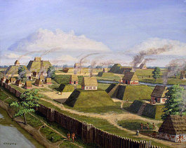
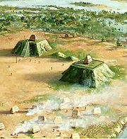
This is a list of Mississippian sites. The Mississippian culture was a mound-building Native American
culture that flourished in what is now the Midwestern
, Eastern
, and Southeastern
United States
from approximately 800 CE
to 1500 CE
, varying regionally.
Native Americans in the United States
Native Americans in the United States are the indigenous peoples in North America within the boundaries of the present-day continental United States, parts of Alaska, and the island state of Hawaii. They are composed of numerous, distinct tribes, states, and ethnic groups, many of which survive as...
culture that flourished in what is now the Midwestern
Midwestern United States
The Midwestern United States is one of the four U.S. geographic regions defined by the United States Census Bureau, providing an official definition of the American Midwest....
, Eastern
Eastern United States
The Eastern United States, the American East, or simply the East is traditionally defined as the states east of the Mississippi River. The first two tiers of states west of the Mississippi have traditionally been considered part of the West, but can be included in the East today; usually in...
, and Southeastern
Southeastern United States
The Southeastern United States, colloquially referred to as the Southeast, is the eastern portion of the Southern United States. It is one of the most populous regions in the United States of America....
United States
United States
The United States of America is a federal constitutional republic comprising fifty states and a federal district...
from approximately 800 CE
Common Era
Common Era ,abbreviated as CE, is an alternative designation for the calendar era originally introduced by Dionysius Exiguus in the 6th century, traditionally identified with Anno Domini .Dates before the year 1 CE are indicated by the usage of BCE, short for Before the Common Era Common Era...
to 1500 CE
Common Era
Common Era ,abbreviated as CE, is an alternative designation for the calendar era originally introduced by Dionysius Exiguus in the 6th century, traditionally identified with Anno Domini .Dates before the year 1 CE are indicated by the usage of BCE, short for Before the Common Era Common Era...
, varying regionally.
| Site | Image | Description |
|---|---|---|
| Adams Site Adams Site The Adams Site is a Mississippian culture archaeological site located near Hickman in Fulton County, Kentucky,on Bayou de Chien, a creek that drains into the nearby Mississippi River. The 7.25 hectare site is built over the remains of a Late Woodland village... |
Located near Hickman Hickman, Kentucky Hickman is a city in Fulton County, Kentucky, United States. The population was 2,560 at the 2000 census. Named for Captain Paschal Hickman, a Kentucky officer who was killed by Indians in the Massacre of the River Raisin during the War of 1812, it is the county seat of Fulton County.Hickman is... in Fulton County, Kentucky Fulton County, Kentucky Fulton County is the westernmost county of the U.S. state of Kentucky. It was formed in 1845 from Hickman County, Kentucky. As of 2000, the population was 7,752. Its county seat is Hickman. The county is named for American inventor Robert Fulton... , it consists of a 7.25 hectare village area built over the remains of a Late Woodland Woodland period The Woodland period of North American pre-Columbian cultures was from roughly 1000 BCE to 1000 CE in the eastern part of North America. The term "Woodland Period" was introduced in the 1930s as a generic header for prehistoric sites falling between the Archaic hunter-gatherers and the... village with a central group of platform mounds around a central plaza and another smaller plaza area to the southwest of the largest mound, occupied during the Medley(1100 to 1300) and Jackson(1300 to 1500) Phases of the local chronology. |
|
| Angel Mounds Angel Mounds Angel Mounds State Historic Site is located on the Ohio River in Vanderburgh and Warrick Counties eight miles southeast of Evansville and just upriver of the confluence of the Green and Ohio rivers. Administered by the Indiana Department of Natural Resources, Division of Indiana State Museums... |
A chiefdom in southern Indiana Indiana Indiana is a US state, admitted to the United States as the 19th on December 11, 1816. It is located in the Midwestern United States and Great Lakes Region. With 6,483,802 residents, the state is ranked 15th in population and 16th in population density. Indiana is ranked 38th in land area and is... near Evansville. |
|
| Ashworth Archaeological Site Ashworth Archaeological Site The Ashworth Archaeological Site is a significant archaeological site in the extreme southwestern corner of the U.S. state of Indiana. Located near the confluence of the Ohio and Wabash Rivers, it lies near several similar archaeological sites... |
An archaeological site of the Caborn-Welborn variant of the Mississippian culture. | |
| Aztalan State Park Aztalan State Park Aztalan State Park is a Wisconsin state park located just south of the town of Aztalan, Wisconsin at latitude N 43° 4' and longitude W 88° 52', and established in 1952. It was also designated a National Historic Landmark in 1964 and added to the National Register of Historic Places in 1966... |
 |
A small Mississippian chiefdom in Wisconsin, the northern edge of the greater Mississippian culture |
| Battle Mound Site Battle Mound Site The Battle Mound Site is an archaeological site in Lafayette County, Arkansas in the Great Bend region of the Red River basin. The majority of the mound was built from 1200-1400 CE. The site has the largest mound of the Caddoan Mississippian culture , and measures approximately 670 feet in length,... |
Located in Lafayette County, Arkansas in the Great Bend region of the Red River basin and has the largest mound Platform mound A platform mound is any earthwork or mound intended to support a structure or activity.-Eastern North America:The indigenous peoples of North America built substructure mounds for well over a thousand years starting in the Archaic period and continuing through the Woodland period... of the Caddoan Mississippian culture Caddoan Mississippian culture The Caddoan Mississippian culture was a prehistoric Native American culture considered by archaeologists as a variant of the Mississippian culture. The Caddoan Mississippians covered a large territory, including what is now Eastern Oklahoma, Western Arkansas, Northeast Texas, and Northwest Louisiana... |
|
| Beasley Mounds Site Beasley Mounds Site The Beasley Mounds Site is a Mississippian culture archaeological site located at the confluence of Dixon Creek and the Cumberland River near the unincorporated community of Dixon Springs in Smith County, Tennessee. The site was first excavated by amateur archaeologists in the 1890s... |
Also known as the Dixon Springs Mound Site, located at the confluence of Dixon Creek and the Cumberland River Cumberland River The Cumberland River is a waterway in the Southern United States. It is long. It starts in Harlan County in far southeastern Kentucky between Pine and Cumberland mountains, flows through southern Kentucky, crosses into northern Tennessee, and then curves back up into western Kentucky before... near the unincorporated community of Dixon Springs Dixon Springs, Tennessee Dixon Springs is an unincorporated community in Smith County, Tennessee, United States.Once a thriving area between Carthage and Hartsville, the community is still quaint with many antebellum homes and significant cemeteries of early settlers in the area, including that of Col. William Martin,... in Smith County, Tennessee. More examples of Mississippian stone statuary Mississippian stone statuary The Mississippian stone statuary are artifacts of polished stone in the shape of human figurines made by members of the Mississippian culture and found in archaeological sites in the American Midwest and Southeast... have been found at the site than any other in the Middle Tennessee area. |
|
| Belcher Mound Site Belcher Mound Site The Belcher Mound Site is an archaeological site in Caddo Parish, Louisiana. It is located in the Red River Valley 20 miles north of Shreveport and about one-half mile east of the town of Belcher, Louisiana. It was excavated by Clarence H. Webb from 1959 to 1969... |
A Caddoan site located in Caddo Parish, Louisiana Caddo Parish, Louisiana Caddo Parish is a parish located in the U.S. state of Louisiana. The parish seat is Shreveport; as of 2000, the population was 252,161... in the Red River Valley 20 miles north of Shreveport Shreveport, Louisiana Shreveport is the third largest city in Louisiana. It is the principal city of the fourth largest metropolitan area in the state of Louisiana and is the 109th-largest city in the United States.... and about one-half mile east of the town of Belcher, Louisiana Belcher, Louisiana Belcher is a village in Caddo Parish, Louisiana, United States. The population was 272 at the 2000 census. It is part of the Shreveport–Bossier City Metropolitan Statistical Area.-Geography:Belcher is located at .... |
|
| Boyd Mounds Site | A site from the Late Woodland and later Mississippian culture located in Madison County, Mississippi Madison County, Mississippi -Demographics:As of the census of 2000, there were 74,674 people, 27,219 households, and 19,325 families residing in the county. The population density was 104 people per square mile . There were 28,781 housing units at an average density of 40 per square mile... near Ridgeland Ridgeland, Mississippi Ridgeland is a city in Madison County, Mississippi, United States. The population was 20,173 at the 2000 census. It is part of the Jackson Metropolitan Statistical Area.-Geography:... . It is located at mile 106.9 on the old Natchez Trace Natchez Trace The Natchez Trace, also known as the "Old Natchez Trace", is a historical path that extends roughly from Natchez, Mississippi to Nashville, Tennessee, linking the Cumberland, Tennessee and Mississippi rivers... , now the Natchez Trace Parkway Natchez Trace Parkway The Natchez Trace Parkway is a National Park Service unit in the southeastern United States that commemorates the historic Old Natchez Trace and preserves sections of the original trail.... . |
|
| Brentwood Library Site Brentwood Library Site The Brentwood Library Site , also known as the Jarman Farm Site, is a Mississippian culture archaeological site located in the city of Brentwood, in Williamson County, Tennessee... |
Also known as the Jarman Farm Site, it is a village and associated burial area located in Brentwood, Tennessee. It was occupied during the Thurston Phase of the local chronology and artifacts from the site have been radiocarbon dated to 1298 to 1465 CE. | |
| Brick Church Mound and Village Site Brick Church Mound and Village Site The Brick Church Mound and Village Site is a Mississippian culture archaeological site located in Nashville in Davidson County, Tennessee. It was excavated in the late nineteenth century by Frederic Ward Putnam... |
A multi-mound palisaded village site located in Nashville Nashville, Tennessee Nashville is the capital of the U.S. state of Tennessee and the county seat of Davidson County. It is located on the Cumberland River in Davidson County, in the north-central part of the state. The city is a center for the health care, publishing, banking and transportation industries, and is home... in Davidson County, Tennessee Davidson County, Tennessee Davidson County is a county located in the U.S. state of Tennessee. As of 2010, the population was 626,681. Its county seat is Nashville.In 1963, the City of Nashville and the Davidson County government merged, so the county government is now known as the "Metropolitan Government of Nashville and... |
|
| Bussell Island Bussell Island Bussell Island, formerly Lenoir Island, is an island located at the mouth of the Little Tennessee River near the U.S. city of Lenoir City, Tennessee. The island was inhabited by various Native American cultures for thousands of years before the arrival of early European explorers, and is currently... |
An island at the mouth of the Little Tennessee River Little Tennessee River The Little Tennessee River is a tributary of the Tennessee River, approximately 135 miles long, in the Appalachian Mountains in the southeastern United States.-Geography:... in Loudon County, Tennessee, believed to have been the location "Coste," visited by de Soto in 1540 |
|
| Caddoan Mounds State Historic Site Caddoan Mounds State Historic Site The Caddoan Mounds State Historic Site is an archaeological site in Cherokee County, Texas built by the Caddoan Mississippian culture. The site has two platform mounds and one burial mound. Archaeologists believe the site was founded in approximately 800 CE, with most major construction taking... |
Also known as the George C. Davis Site (41CE19), a Caddoan Mississippian site located in Cherokee County, Texas Cherokee County, Texas As of the census of 2000, there were 46,659 people, 16,651 households, and 12,105 families residing in the county. The population density was 44 people per square mile . There were 19,173 housing units at an average density of 18 per square mile... 26 miles west of Nacogdoches, Texas Nacogdoches, Texas Nacogdoches is a city in Nacogdoches County, Texas, in the United States. The 2010 census recorded the city's population to be 32,996. It is the county seat of Nacogdoches County and is situated in East Texas. Nacogdoches is a sister city of Natchitoches, Louisiana.Nacogdoches is the home of... on Texas State Highway 21 near its intersection with U.S. Route 69 U.S. Route 69 U.S. Route 69 is a north–south United States highway. When it was first created, it was only long, but it has since been expanded into a Minnesota to Texas cross-country route. The highway's southern terminus is in Port Arthur, Texas at an intersection with State Highway 87... in the Piney Woods Piney Woods The Piney Woods is a temperate coniferous forest terrestrial ecoregion in the Southern United States covering of East Texas, southern Arkansas, western Louisiana, and southeastern Oklahoma. These coniferous forests are dominated by several species of pine as well as hardwoods including hickory and... region of east Texas |
|
| Cahokia Cahokia Cahokia Mounds State Historic Site is the area of an ancient indigenous city located in the American Bottom floodplain, between East Saint Louis and Collinsville in south-western Illinois, across the Mississippi River from St. Louis, Missouri. The site included 120 human-built earthwork mounds... |
 |
Near East St. Louis, Illinois, Cahokia was possibly the first, and certainly the largest and most influential of the Mississippian mound centers |
| Campbell Archeological Site Campbell Archeological Site The Campbell Archeological Site , is an archaeological site in Southeastern Missouri occupied by the Late Mississippian Period Nodena Phase from 1350 to 1541 CE. The site features a large mound and village, as well as a cemetery area. The site was excavated by amateur archaeologist Leo O... |
The Campbell Archeological Site ( 23 PM 5), is a site in Southeastern Missouri occupied by the Late Mississippian Period Nodena Phase Nodena Phase The Nodena Phase is an archaeological phase in eastern Arkansas and southeastern Missouri of the Late Mississippian culture which dates from about 1400–1650 CE. The Nodena Phase is known from a collection of villages along the Mississippi River between the Missouri Bootheel and Wapanocca Lake... from 1350 to 1541 CE. |
|
| Castalian Springs Mound Site Castalian Springs Mound Site The Castalian Springs Mound Site is a Mississippian culture archaeological site located near the small unincorporated community of Castalian Springs in Sumner County, Tennessee. The site was first excavated in the 1890s and again as recently as the 2005 to 2011 archaeological field school led by... |
 |
In Castalian Springs, Tennessee Castalian Springs, Tennessee Castalian Springs is an unincorporated community in Sumner County, Tennessee, United States. It is located along Tennessee State Route 25 about seven miles east of Gallatin, Tennessee. The area has its own post office. The Zip Code for Castalian Springs is 37031... , the site was once home to a substantial Mississippian-period (1000-1400 CE) village with 12 known mounds at the site |
| Chucalissa Indian Village | The site is a Walls Phase Walls Phase The Walls Phase is an archaeological phase in southwestern Tennessee and northwestern Mississippi of the Late Mississippian culture. Chucalissa Indian Village is a Walls Phase mound and plaza complex located on a bluff overlooking the Mississippi River. Other contemporaneous groups in the area... Mississippian site dating back to the 15th century, located in the city of Memphis Memphis, Tennessee Memphis is a city in the southwestern corner of the U.S. state of Tennessee, and the county seat of Shelby County. The city is located on the 4th Chickasaw Bluff, south of the confluence of the Wolf and Mississippi rivers.... in West Tennessee Tennessee Tennessee is a U.S. state located in the Southeastern United States. It has a population of 6,346,105, making it the nation's 17th-largest state by population, and covers , making it the 36th-largest by total land area... and was occupied, abandoned and reoccupied several times throughout its history, spanning from 1000 to 1550 CE. |
|
| Cloverdale archaeological site Cloverdale archaeological site The Cloverdale archaeological site is an important archaeological site near St. Joseph, Missouri. It is located at the mouth of a small valley that opens into the Missouri River.... |
An important archaeological site near St. Joseph, Missouri Saint Joseph, Missouri Saint Joseph is the second largest city in northwest Missouri, only second to Kansas City in size, serving as the county seat for Buchanan County. As of the 2010 census, Saint Joseph had a total population of 76,780, making it the eighth largest city in the state. The St... . It is located at the mouth of a small valley that opens into the Missouri River Missouri River The Missouri River flows through the central United States, and is a tributary of the Mississippi River. It is the longest river in North America and drains the third largest area, though only the thirteenth largest by discharge. The Missouri's watershed encompasses most of the American Great... . It was occupied by Kansas City Hopewell Kansas City Hopewell The Kansas City Hopewell were the farthest west regional variation of the Hopewell tradition of the Middle Woodland period . Sites were located in Kansas and Missouri around the mouth of the Kansas River where it enters the Missouri River... (ca. 100 to 500 CE) peoples and later by Mississippian influenced Steed-Kisker Steed-Kisker The Steed-Kisker culture is a cultural phase that is part of the larger Central Plains Tradition of prehistoric people who occupied the Great Plains region of the United States in prehistoric times. This group lived primarily around the Kansas City, Missouri area from about 900 to 1400 CE... peoples(ca. 1200 CE). Because of the many Cahokia style projectile points found at the site, it is believed to have been a trade partner or outpost of the much larger Cahokia polity. |
|
| Dickson Mounds Dickson Mounds Dickson Mounds is a Native American settlement site and burial mound complex near Lewistown, Illinois, is located in Fulton County on a low bluff overlooking the Illinois River. It is a large burial complex containing at least two cemeteries, ten burial mounds, and a platform mound. Dickson Mounds... |
A settlement site and burial mound complex near Lewistown, Illinois Lewistown, Illinois Lewistown is a city in Fulton County, Illinois, United States. The population was 2,522 at the 2000 census. It is the county seat of Fulton County. Located in central Illinois, it is southwest of Peoria. It is the source of Spoon River Anthology by Edgar Lee Masters, who lived there... in Fulton County Fulton County, Illinois Fulton County is a county located in the U.S. state of Illinois. According to the 2010 census, it has a population of 37,069, which is a decrease of 3.1% from 38,250 in 2000. Its county seat is Lewistown. Canton is the largest city. Both cities are southwest of Peoria, and the county is considered... on a low bluff overlooking the Illinois River Illinois River The Illinois River is a principal tributary of the Mississippi River, approximately long, in the State of Illinois. The river drains a large section of central Illinois, with a drainage basin of . This river was important among Native Americans and early French traders as the principal water route... . The site is named in honor of chiropractor Don Dickson, who began excavating it in 1927 and opened a private museum that formerly operated on the site. |
|
| Eaker Site Eaker Site Eaker Site is an archaeological site on Eaker Air Force Base near Blytheville, Arkansas that was declared a National Historic Landmark in 1996.... |
The site is the largest and most intact Late Mississippian Nodena Phase Nodena Phase The Nodena Phase is an archaeological phase in eastern Arkansas and southeastern Missouri of the Late Mississippian culture which dates from about 1400–1650 CE. The Nodena Phase is known from a collection of villages along the Mississippi River between the Missouri Bootheel and Wapanocca Lake... village site within the Central Mississippi Valley. |
|
| Emerald Mound Site Emerald Mound Site The Emerald Mound Site , also known as the Selzertown site, is a Plaquemine culture Mississippian period archaeological site located on the Natchez Trace Parkway near Stanton, Mississippi, United States. The site dates from the period between 1200 and 1730 CE... |
A Plaquemine Plaquemine culture The Plaquemine culture was an archaeological culture in the lower Mississippi River Valley in western Mississippi and eastern Louisiana. Good examples of this culture are the Medora Site in West Baton Rouge Parish, Louisiana, and the Anna, Emerald Mound, Winterville and Holly Bluff sites located... Mississippian period archaeological site located on the Natchez Trace Parkway near Stanton, Mississippi. The site dates from the period between 1200 and 1730 CE. The platform mound is the second-largest Pre-Columbian earthwork in the country, after Monk's Mound Monk's Mound Monks Mound is the largest Pre-Columbian earthwork in America north of Mesoamerica. Located at the Cahokia Mounds UNESCO World Heritage Site near Collinsville, Illinois, its size was calculated in 1988 as about 100 feet high, 955 feet long including the access ramp at the southern end, and 775... at Cahokia |
|
| Etowah Indian Mounds Etowah Indian Mounds Etowah Indian Mounds is a archaeological site in Bartow County, Georgia south of Cartersville, in the United States. Built and occupied in three phases, from 1000–1550 CE, the prehistoric site is located on the north shore of the Etowah River. Etowah Indian Mounds Historic Site is a designated... |
One of the major Mississippian chiefdoms, located in Georgia Georgia (U.S. state) Georgia is a state located in the southeastern United States. It was established in 1732, the last of the original Thirteen Colonies. The state is named after King George II of Great Britain. Georgia was the fourth state to ratify the United States Constitution, on January 2, 1788... , believed by some to be a long-standing antagonist of the Moundville polity. |
|
| Fewkes Group Archaeological Site Fewkes Group Archaeological Site Fewkes Group Archaeological Site , also known as the Boiling Springs Site, is a prehistoric Native American archaeological site located in the city of Brentwood, in Williamson County, Tennessee. It is in Primm Historic Park on the grounds of Boiling Spring Academy, a historic schoolhouse... |
Located in the city of Brentwood Brentwood, Tennessee -Demographics:As of the census of 2000, there were 23,445 people, 7,693 households, and 6,808 families residing in the city. The population density was . There were 7,889 housing units at an average density of . The racial makeup of the city was 94.63% European American, 1.89% African American,... , in Williamson County, Tennessee Williamson County, Tennessee Williamson County is a county in the U.S. state of Tennessee. As of 2010 US Census, the population was 183,182. The County's seat is Franklin, and it is part of the Nashville-Davidson–Murfreesboro–Franklin Metropolitan Statistical Area. The county is named after Hugh Williamson, a... . The 15-acre site consists of the remains of a Late Mississippian culture mound complex and village roughly dating to 1050-1475 CE. The site, which sits on the western bank of the Little Harpeth River Little Harpeth River The Little Harpeth River is a tributary of the Harpeth River in Tennessee, just south of Nashville. Via the Harpeth, Cumberland, and Ohio rivers, it is part of the Mississippi River watershed.... , has five mounds, some used for burials and others, including the largest, were ceremonial platform mounds. |
|
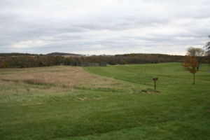
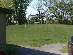
| Fort Walton Mound |  |
The Fort Walton Mound was built about 1300 CE by Fort Walton Culture Fort Walton Culture Fort Walton Culture was a mound-building Native American culture that flourished in southeastern North America, from approximately 1100~1550 CE.... . Located in Fort Walton Beach, Florida Fort Walton Beach, Florida Fort Walton Beach is a city in southern Okaloosa County, Florida, United States. As of 2005, the population estimate for Fort Walton Beach was 19,992, and as of 2010, the population estimate for Fort Walton Beach is 19,507 recorded by the U.S. Census Bureau... , near the intersection of State Road 85 and U.S. Route 98 U.S. Route 98 U.S. Route 98 is an east–west United States highway that runs from western Mississippi to southern Florida. It was established in 1933 as a route between Pensacola, Florida and Apalachicola, Florida, and has since been extended westward into Mississippi and eastward across the Florida... , in the Florida Panhandle Florida Panhandle The Florida Panhandle, an informal, unofficial term for the northwestern part of Florida, is a strip of land roughly 200 miles long and 50 to 100 miles wide , lying between Alabama on the north and the west, Georgia also on the north, and the Gulf of Mexico to the south. Its eastern boundary is... . |
| Garden Creek site Garden Creek site Garden Creek site is an archaeological site located west of Asheville, North Carolina, at the confluence of the Pigeon River and Garden Creek near Canton and the Pisgah National Forest. The site features two Pisgah Phase villages and the three Garden Creek Mounds... |
Two Pisgah Phase Pisgah Phase The Pisgah Phase is an archaeological phase of the South Appalachian Mississippian culture in parts of Northeastern Tennessee, Western North Carolina and Northwestern South Carolina.-Location:... villages, occupied from 600–1200 CE, and three mounds (31Hw1-3) in Haywood County, North Carolina Haywood County, North Carolina -National protected areas:* Blue Ridge Parkway * Great Smoky Mountains National Park * Pisgah National Forest -Major Highways & Roads:* Interstate 40* U.S. Highway 19* U.S. Highway 23* U.S. Highway 74* U.S... |
|
| Grand Village of the Natchez Grand Village of the Natchez Grand Village of the Natchez, also known as the Fatherland Site, is a site encompassing a prehistoric indigenous village and earthwork mounds in present-day south Natchez, Mississippi. The village complex was constructed starting about 1200 CE by members of the prehistoric Plaquemine culture.... |
 |
The main village of the Natchez people Natchez people The Natchez are a Native American people who originally lived in the Natchez Bluffs area, near the present-day city of Natchez, Mississippi. They spoke a language isolate that has no known close relatives, although it may be very distantly related to the Muskogean languages of the Creek... , with three mounds. A mound site used and maintained into historic times |
| Holly Bluff Site Holly Bluff Site The Holly Bluff Site , sometimes known as the Lake George Site, and locally as “The Mound Place,”) is an archaeological site that is a type site for the Lake George phase of the prehistoric Plaquemine culture period of the area... |
 |
Type site for the Lake George phase of the Plaquemine culture Plaquemine culture The Plaquemine culture was an archaeological culture in the lower Mississippi River Valley in western Mississippi and eastern Louisiana. Good examples of this culture are the Medora Site in West Baton Rouge Parish, Louisiana, and the Anna, Emerald Mound, Winterville and Holly Bluff sites located... , on the southern margin of the Mississippian cultural advance down the Mississippi River and on the northern edge of the Cole's Creek Coles Creek culture Coles Creek culture is a Late Woodland archaeological culture in the Lower Mississippi valley in the southern United States. It followed the Troyville culture. The period marks a significant change in the cultural history of the area... and Plaquemine cultures of the South |
| Hovey Lake-Klein Archeological Site Hovey Lake-Klein Archeological Site Hovey Lake-Klein Archeological Site is an archaeological site of the Caborn-Welborn variant of the Mississippian culture. Hovey Lake-Klein Archeological Site is located on the west bank of Hovey Lake, a backwater lake near the Ohio River close to its confluence with the Wabash River... |
A Caborn-Welborn site, located on the west bank of Hovey Lake, a backwater lake near the Ohio River Ohio River The Ohio River is the largest tributary, by volume, of the Mississippi River. At the confluence, the Ohio is even bigger than the Mississippi and, thus, is hydrologically the main stream of the whole river system, including the Allegheny River further upstream... close to its confluence with the Wabash River Wabash River The Wabash River is a river in the Midwestern United States that flows southwest from northwest Ohio near Fort Recovery across northern Indiana to southern Illinois, where it forms the Illinois-Indiana border before draining into the Ohio River, of which it is the largest northern tributary... . The site was an extensive village occupation dating between 1400-1650 CE. |
|
| Jaketown Site Jaketown Site Jaketown Site is an archaeological site with two prehistoric earthwork mounds in Humphreys County, Mississippi, United States. While the mounds have not been excavated, distinctive pottery sherds found in the area lead scholars to date the mounds' construction and use to the Mississippian culture... |
 |
A site with two in Humphreys County, Mississippi Humphreys County, Mississippi -Demographics:At the 2000 census, there were 11,206 people, 3,765 households and 2,695 families residing in the county. The population density was 27 per square mile . There were 4,138 housing units at an average density of 10 per square mile... dating from roughly 1100 CE to 1500 CE, located along Mississippi Highway 7 approximately seven miles north of Belzoni Belzoni, Mississippi Belzoni is a city in Humphreys County, Mississippi, in the Mississippi Delta region, on the Yazoo River. The population was 2,663 at the 2000 census. It is the county seat of Humphreys County... . The largest platform mound at the site, Mound B,is 23 feet (7 m) in height with a base of 150 feet (45.7 m) by 200 feet (61 m). It has a projection on its eastern side that is thought to have been a ramp once used as a stairway. To its northeast is Mound C, another platform mound with a height of 15 feet (4.6 m). |
| Joara Joara Joara was a large Native American settlement, a regional chiefdom of the Mississippian culture, located in what is now Burke County, North Carolina. Joara is notable as a significant archaeological and historic site. It was a place of encounter in 1540 between the Mississippian people and the... |
The largest chiefdom in North Carolina North Carolina North Carolina is a state located in the southeastern United States. The state borders South Carolina and Georgia to the south, Tennessee to the west and Virginia to the north. North Carolina contains 100 counties. Its capital is Raleigh, and its largest city is Charlotte... at contact; also possibly the furthest northeastern Mississippian chiefdom center, near Morganton |
|
| Jordan Mounds Jordan Mounds Jordan Mounds is a multimound archaeological site in Morehouse Parish, Louisiana. It is the type site for the Jordan Phase of the local chronology. The site was constructed during the protohistoric period between 1540 and 1685.-Description:... |
A multimound site (16 MO 1) in Morehouse Parish, Louisiana Morehouse Parish, Louisiana Morehouse Parish is a parish located in the U.S. state of Louisiana. The parish seat is Bastrop. In 2000, the parish population was 31,021.... near Oak Ridge, Louisiana Oak Ridge, Louisiana Oak Ridge is a village in Morehouse Parish, Louisiana, United States. The population was 142 at the 2000 census. It is part of the Bastrop Micropolitan Statistical Area.-Geography:Oak Ridge is located at .... . The site was constructed during the protohistoric period between 1540 and 1685. |
|
| Kincaid Mounds State Historic Site Kincaid Mounds State Historic Site The Kincaid Mounds Historic Site, circa 1050-1400 CE, was among the largest prehistoric Mississippian culture chiefdom centers, located at the southern tip of present day U.S. state of Illinois... |
 |
A major Mississippian mound center in southern Illinois Illinois Illinois is the fifth-most populous state of the United States of America, and is often noted for being a microcosm of the entire country. With Chicago in the northeast, small industrial cities and great agricultural productivity in central and northern Illinois, and natural resources like coal,... across the Ohio River Ohio River The Ohio River is the largest tributary, by volume, of the Mississippi River. At the confluence, the Ohio is even bigger than the Mississippi and, thus, is hydrologically the main stream of the whole river system, including the Allegheny River further upstream... from Paducah, Kentucky Paducah, Kentucky Paducah is the largest city in Kentucky's Jackson Purchase Region and the county seat of McCracken County, Kentucky, United States. It is located at the confluence of the Tennessee River and the Ohio River, halfway between the metropolitan areas of St. Louis, Missouri, to the west and Nashville,... . |
| Letchworth Mounds Letchworth Mounds Letchworth-Love Mounds is a Florida State Park that preserves the state's tallest prehistoric, Native American ceremonial earthwork mound, which is high. It is estimated to have been built 1100 to 1800 years ago. This is one of three major surviving mound complexes in the Florida Panhandle... |
A Fort Walton Culture Fort Walton Culture Fort Walton Culture was a mound-building Native American culture that flourished in southeastern North America, from approximately 1100~1550 CE.... Florida State Park Florida State Parks The Florida State Parks encompass the majority of the lands that fall under the authority of the Florida Department of Environmental Protection. There are 160 such entities, including nature reserves, recreation areas, and historic sites, which can be found in every corner of the state... located approximately six miles west of Monticello Monticello, Florida Monticello is a city in Jefferson County, Florida, United States. The population was 2,533 at the 2000 census. As of 2004, the population recorded by the U.S. Census Bureau is 2,572. It is the county seat of Jefferson County... , a half mile south of U.S. 90 U.S. Route 90 U.S. Route 90 is an east–west United States highway. Despite the "0" in its route number, U.S. 90 never was a full coast-to-coast route; it has always ended at Van Horn, Texas. A short-lived northward extension to U.S... , in northwestern Florida Florida Florida is a state in the southeastern United States, located on the nation's Atlantic and Gulf coasts. It is bordered to the west by the Gulf of Mexico, to the north by Alabama and Georgia and to the east by the Atlantic Ocean. With a population of 18,801,310 as measured by the 2010 census, it... . It contains the state's tallest ceremonial mound (46 feet), estimated to have been built 1100 to 1800 years ago. |
|
| Lake Jackson Mounds Archaeological State Park Lake Jackson Mounds Archaeological State Park Lake Jackson Mounds Archaeological State Park is one of the most important archaeological sites in Florida, a former chiefdom and ceremonial center of the Fort Walton Culture... |
 |
The site is one of the most important sites in Florida, a former chiefdom and ceremonial center of the Fort Walton Culture Fort Walton Culture Fort Walton Culture was a mound-building Native American culture that flourished in southeastern North America, from approximately 1100~1550 CE.... . The complex originally included six mounds, a constructed plaza and numerous individual village residences. Located in the Florida Panhandle Florida Panhandle The Florida Panhandle, an informal, unofficial term for the northwestern part of Florida, is a strip of land roughly 200 miles long and 50 to 100 miles wide , lying between Alabama on the north and the west, Georgia also on the north, and the Gulf of Mexico to the south. Its eastern boundary is... , it is in northern Tallahassee Tallahassee, Florida Tallahassee is the capital of the U.S. state of Florida. It is the county seat and only incorporated municipality in Leon County, and is the 128th largest city in the United States. Tallahassee became the capital of Florida, then the Florida Territory, in 1824. In 2010, the population recorded by... , on the south shore of Lake Jackson Lake Jackson (Tallahassee, Florida) Lake Jackson is a shallow, prairie lake on the north side of Tallahassee in Leon County, Florida with two major depressions or sinkholes known as Porter Sink and Lime Sink.... . |
| Liddell Archeological Site Liddell Archeological Site The Liddell Archeological Site is a prehistoric Native American site in Wilcox County, Alabama. The site covers and shows evidence of human occupation from 9000 BC to 1800 AD. It is best known for its Mississippian artifacts, primarily from the Burial Urn Culture period... |
Located in Wilcox County, Alabama Wilcox County, Alabama Wilcox County is a county of the U.S. state of Alabama. Its name is in honor of Lieutenant J. M. Wilcox, who fought in the wars against the Creek tribe. As of 2010, the population was 11,670... , it covers 50 acres (20.2 ha) and shows evidence of human occupation from 9000 BCE to 1800 CE. It is best known for its Mississippian artifacts from the Burial Urn Culture period. The Liddell, Stroud, and Hall families donated the site to Auburn University Auburn University Auburn University is a public university located in Auburn, Alabama, United States. With more than 25,000 students and 1,200 faculty members, it is one of the largest universities in the state. Auburn was chartered on February 7, 1856, as the East Alabama Male College, a private liberal arts... after its discovery. |
|
| Mangum Mound Site Mangum Mound Site Mangum Mound Site is an archaeological site of the Plaquemine culture in Claiborne County, Mississippi. It is located at milepost 45.7 on the Natchez Trace Parkway. Two very rare Mississippian culture repoussé copper plates have been discovered during excavations of the site... |
A Plaquemine site in Claiborne County, Mississippi Claiborne County, Mississippi -Demographics:As of the census of 2000, there were 11,831 people, 3,685 households, and 2,531 families residing in the county. The population density was 24 people per square mile . There were 4,252 housing units at an average density of 9 per square mile... , located at milepost 45.7 on the Natchez Trace Parkway Natchez Trace Parkway The Natchez Trace Parkway is a National Park Service unit in the southeastern United States that commemorates the historic Old Natchez Trace and preserves sections of the original trail.... . An avian designed repoussé Repoussé and chasing Repoussé or repoussage is a metalworking technique in which a malleable metal is ornamented or shaped by hammering from the reverse side to create a design in low relief. There are few techniques that offer such diversity of expression while still being relatively economical... copper plate was discovered there in 1936. |
|
| Marshall Site Marshall Site The Marshall Site is an Early Mississippian culture archaeological site located near Bardwell in Carlisle County, Kentucky, on a bluff spur overlooking the Mississippi River floodplain. The site was occupied from about 900 to about 1300 CE during the James Bayou Phase of the local chronology and... |
An Early Mississippian site located near Bardwell Bardwell, Kentucky Bardwell is a city in Carlisle County, Kentucky, United States. The population was 799 at the 2000 census. It is the county seat of Carlisle County.-Geography:Bardwell is located at .... in Carlisle County, Kentucky Carlisle County, Kentucky Carlisle County is a county located in the U.S. state of Kentucky. It was formed in 1886 and as of 2000, had a population of 5,351. Its county seat is Bardwell, Kentucky. The county is named for John Griffin Carlisle, a Speaker of the United States House of Representatives from Kentucky... , on a bluff spur overlooking the Mississippi River floodplain. It was occupied from about 900 to about 1300 CE during the James Bayou Phase of the local chronology and abandoned sometime during the succeeding Dorena Phase. A large village site with evidence of once having had platform mound and earthworks. |
|
| Menard-Hodges Site Menard-Hodges Site The Menard-Hodges Site , is an archaeological site in Arkansas. It includes two large mounds as well as several house mounds. It is the type site for the Menard phase, a protohistoric Mississippian culture group. It is considered as a possible candidate for the Province of Anilco encountered by the... |
In Arkansas Arkansas Arkansas is a state located in the southern region of the United States. Its name is an Algonquian name of the Quapaw Indians. Arkansas shares borders with six states , and its eastern border is largely defined by the Mississippi River... , it includes two large mounds as well as several house mounds, possibly the Province of Anilco encountered by the Hernando de Soto Entrada in 1540. |
|
| Mitchell Archaeological Site Mitchell Archaeological Site The Mitchell Site is an archaeological site in Davison County, South Dakota, near Mitchell, South Dakota. It was declared a National Historic Landmark in 1964.At the time of the designation in 1964, it was stated:... |
A site in Davison County, South Dakota Davison County, South Dakota As of the census of 2000, there were 18,741 people, 7,585 households, and 4,770 families residing in the county. The population density was 43 people per square mile . There were 8,093 housing units at an average density of 19 per square mile... , near Mitchell, South Dakota Mitchell, South Dakota -Demographics:As of the census of 2000, there were 14,558 people, 6,121 households, and 3,599 families residing in the city. The population density was 1,475.7 people per square mile . There were 6,555 housing units at an average density of 664.4 per square mile... . Mitchell Site is the only reliably dated site (c. 1000) pertaining to the Lower James River Phase (Initial Variant) of the migration of late Mississippian culture to the Middle Missouri Valley. It is distinctive for its evidence relating mortuary practices to other intra-site practices. |
|
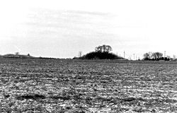
| Mound Bottom Mound Bottom Mound Bottom is a prehistoric Native American complex in Cheatham County, Tennessee, located in the Southeastern United States. The complex, which consists of platform and burial mounds, a central plaza, and habitation areas, was built between 950 and 1300 AD, during the Mississippian period.The... |
 |
The complex in Cheatham County, Tennessee consists of ceremonial and burial mounds, a central plaza, and habitation areas, built between 950 and 1300 CE |
| Moundville Archaeological Site Moundville Archaeological Site Moundville Archaeological Site, also known as the Moundville Archaeological Park, is a Mississippian site on the Black Warrior River in Hale County, near the town of Tuscaloosa, Alabama... |
 |
Ranked with Cahokia as one of the two most important sites at the core of the classic Mississippian culture, located near Tuscaloosa, Alabama Tuscaloosa, Alabama Tuscaloosa is a city in and the seat of Tuscaloosa County in west central Alabama . Located on the Black Warrior River, it is the fifth-largest city in Alabama, with a population of 90,468 in 2010... . |
| Murphy Mound Archeological Site Murphy Mound Archeological Site The Murphy Mound Archeological Site , is a prehistoric Mound archaeological site in Caruthersville, located in southeastern Missouri.... |
The Murphy Mound Archeological Site ( 23-PM-43 ), is an archaeological site in Southeastern Missouri occupied from 1350 to 1541 CE. | |
| Nacoochee Mound Nacoochee Mound The Nacoochee Mound is a prehistoric earthen mound on the banks of the Chattahoochee River in White County, in the northeast part of the U.S. state of Georgia, at the junction of Georgia Highways 17 and 75... |
An earthen mound on the banks of the Chattahoochee River Chattahoochee River The Chattahoochee River flows through or along the borders of the U.S. states of Georgia, Alabama, and Florida. It is a tributary of the Apalachicola River, a relatively short river formed by the confluence of the Chattahoochee and Flint Rivers and emptying into Apalachicola Bay in the Gulf of... in White County White County, Georgia White County is a county located in the northeast corner of the U.S. state of Georgia. It was created on December 22, 1857, from part of Habersham County. The county was named for Newton County Representative David T. White, who helped a Habersham representative successfully attain passage of an... , in the northeast part of the state of Georgia Georgia (U.S. state) Georgia is a state located in the southeastern United States. It was established in 1732, the last of the original Thirteen Colonies. The state is named after King George II of Great Britain. Georgia was the fourth state to ratify the United States Constitution, on January 2, 1788... , at the junction of Georgia Highways 17 Georgia State Route 17 State Route 17 is a north–south route located in the U.S. state of Georgia. The route runs from its southern terminus at I-16 south of Bloomingdale north to the North Carolina border north of Hiawassee.-Route description:... and 75 Georgia State Route 75 State Route 75 is a north–south route located in the U.S. state of Georgia in Towns and White Counties. The route runs from its southern terminus in Cleveland, Georgia at S.R. 11/S.R. 75 Alt/U.S. 129 north to the North Carolina border after passing through Hiawassee, Georgia. S. R... . |
|
| Nodena Site Nodena Site The Nodena Site is an archeological site east of Wilson, Arkansas and northeast of Reverie, Tennessee in Mississippi County, Arkansas, United States. Around 1400–1650 CE an aboriginal palisaded village existed in the Nodena area on a meander bend of the Mississippi River. The Nodena site... |
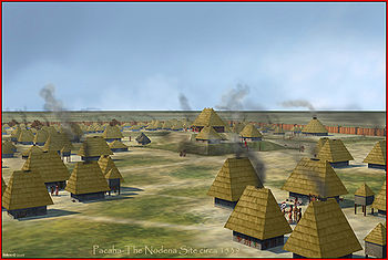 |
Type site for a Late Mississippian Nodena Phase Nodena Phase The Nodena Phase is an archaeological phase in eastern Arkansas and southeastern Missouri of the Late Mississippian culture which dates from about 1400–1650 CE. The Nodena Phase is known from a collection of villages along the Mississippi River between the Missouri Bootheel and Wapanocca Lake... , which dates from about 1400-1700 CE, believed by many archaeologists to be the province Province A province is a territorial unit, almost always an administrative division, within a country or state.-Etymology:The English word "province" is attested since about 1330 and derives from the 13th-century Old French "province," which itself comes from the Latin word "provincia," which referred to... of Pacaha Pacaha Pacaha was a Native American tribe encountered in 1541 by the Hernando de Soto expedition. This tribe inhabited fortified villages in what is today the northeastern portion of the U.S. state of Arkansas... visited by Hernando de Soto in 1542. |
| Ocmulgee National Monument Ocmulgee National Monument Ocmulgee National Monument preserves traces of over ten millennia of Southeastern Native American culture, including major earthworks built more than 1,000 years ago by Mississippian culture peoples: the Great Temple and other ceremonial mounds, a burial mound, and defensive trenches... |
 |
A Mississippian chiefdom, the site was used by the Creek peoples into historic times |
| Old Town Archaeological Site | Village site along the Natchez Trace Natchez Trace The Natchez Trace, also known as the "Old Natchez Trace", is a historical path that extends roughly from Natchez, Mississippi to Nashville, Tennessee, linking the Cumberland, Tennessee and Mississippi rivers... on the banks of the Harpeth River Harpeth River The Harpeth River, long, is one of the major streams of north-central Middle Tennessee and one of the major tributaries of the Cumberland River... in Franklin, Tennessee Franklin, Tennessee Franklin is a city within and the county seat of Williamson County, Tennessee, United States. The population was 62,487 as of the 2010 census Franklin is located approximately south of downtown Nashville.-History:... . Occupancy dated from approximately 900 to 1450 CE. |
|
| Parkin Archeological State Park Parkin Archeological State Park Parkin Archeological State Park, also known as Parkin Indian Mound, is an archeological site and state park in Parkin, Cross County, Arkansas. Around 1350–1650 CE an aboriginal palisaded village existed at the site, at the confluence of the St. Francis and Tyronza Rivers. Artifacts from this... |
 |
The type site for the Late Mississippian Parkin Phase, believed by many archaeologists to be the province of Casqui Casqui Casqui was a Native American tribe discovered in 1541 by the Hernando de Soto expedition. This tribe inhabited fortified villages in eastern Arkansas.... visited by Hernando de Soto in 1542. |
| Rowlandton Mound Site Rowlandton Mound Site The Rowlandton Mound Site is a Mississippian culture archaeological site located in Paducah in McCracken County, Kentucky, on the edge of an old oxbow lake a little south of the Ohio River.The site was occupied from about 1100 to about 1350 CE... |
Located in Paducah Paducah, Kentucky Paducah is the largest city in Kentucky's Jackson Purchase Region and the county seat of McCracken County, Kentucky, United States. It is located at the confluence of the Tennessee River and the Ohio River, halfway between the metropolitan areas of St. Louis, Missouri, to the west and Nashville,... in McCracken County, Kentucky McCracken County, Kentucky McCracken County is a county located in the Jackson Purchase, the extreme western end of the U.S. state of Kentucky. As of 2000, the population was 65,514. The county seat, largest city, and only incorporated community is Paducah.... , on the edge of an old oxbow lake a little south of the Ohio River Ohio River The Ohio River is the largest tributary, by volume, of the Mississippi River. At the confluence, the Ohio is even bigger than the Mississippi and, thus, is hydrologically the main stream of the whole river system, including the Allegheny River further upstream... . The site was occupied from about 1100 to about 1350 CE, the 3 hectare site has a large platform mound and an associated village area. |
|
| Sellars Indian Mound Sellars Indian Mound Sellars Indian Mound is a Mississippian culture archaeological site located in Wilson County, Tennessee near Lebanon. The mound was the site of a settlement from about 1000 to 1300 CE. Today, the site is a satellite unit of Long Hunter State Park... |
 |
A single mound site located near Lebanon, Tennessee Lebanon, Tennessee Lebanon is a city in Wilson County, Tennessee, in the United States. The population was 20,235 at the 2000 census. It serves as the county seat of Wilson County. Lebanon is located in middle Tennessee, approximately 25 miles east of downtown Nashville. Local residents have also called it... from about 1000 CE until 1300 CE |
| Shiloh Indian Mounds Site Shiloh Indian Mounds Site Shiloh Indian Mounds Site is a Mississippian culture archaeological site of the prehistoric indigenous peoples of eastern North America... |
 |
Located beside the Tennessee River Tennessee River The Tennessee River is the largest tributary of the Ohio River. It is approximately 652 miles long and is located in the southeastern United States in the Tennessee Valley. The river was once popularly known as the Cherokee River, among other names... on the grounds of the Shiloh National Military Park Shiloh National Military Park Shiloh National Military Park preserves the American Civil War Shiloh and Corinth battlefields. The main section of the park is in the unincorporated town of Shiloh, about nine miles south of Savannah, Tennessee, with an additional area located in the city of Corinth, Mississippi, 23 miles ... , it was inhabited from around 1000 CE until it was abandoned in approximately 1450 CE. Because it has been included within the national military park for so long it has not been disturbed by modern farming. Remains of the original structures of wattle and daub are still visible as low rings or mounds. It is one of the few places in the eastern U.S. where such remains are visible. |
| Slack Farm Slack Farm Slack Farm is an archaeological site of the Caborn-Welborn variant of the Mississippian culture. Slack Farm is located near Uniontown, Kentucky close to the confluence of the Ohio River and the Wabash Rivers. The site included a Native American mound and an extensive village occupation dating... |
Slack Farm is a site of the Caborn-Welborn culture(a Late Mississippian variant) located near Uniontown, Kentucky Uniontown, Kentucky Uniontown is a city in Union County, Kentucky in the United States of America. The population was 1,064 at the 2000 census. The name derives from the fact that the city was formed by merging the towns of Francisburg and Locust Port. The John T... close to the confluence of the Ohio River Ohio River The Ohio River is the largest tributary, by volume, of the Mississippi River. At the confluence, the Ohio is even bigger than the Mississippi and, thus, is hydrologically the main stream of the whole river system, including the Allegheny River further upstream... and the Wabash River Wabash River The Wabash River is a river in the Midwestern United States that flows southwest from northwest Ohio near Fort Recovery across northern Indiana to southern Illinois, where it forms the Illinois-Indiana border before draining into the Ohio River, of which it is the largest northern tributary... . The site included a mound and an extensive village occupation dating between 1400-1650 CE. |
|
| Spiro Mounds Spiro Mounds Spiro Mounds is an important pre-Columbian Caddoan Mississippian culture archaeological site located in present-day eastern Oklahoma in the United States. The site is located seven miles north of Spiro, and is the only prehistoric Native American archaeological site in Oklahoma open to the public... |
 |
One of the best-studied archaeological centers of Mississippian culture; located in eastern Oklahoma |
| Sugarloaf Mound Sugarloaf Mound Sugarloaf Mound is the sole remaining Mississippian culture platform mound in St. Louis, Missouri. The mound covers three city blocks, measures approximately in height, north/south and east/west. It is located on the former border between St. Louis and the autonomous city of Carondelet. In 1809... |
The sole remaining Mississippian platform mound in St. Louis, Missouri St. Louis, Missouri St. Louis is an independent city on the eastern border of Missouri, United States. With a population of 319,294, it was the 58th-largest U.S. city at the 2010 U.S. Census. The Greater St... . The mound covers three city blocks, measures approximately 40 feet in height, 100 feet north/south and 75 feet east/west. |
|
| Swallow Bluff Island Mounds Swallow Bluff Island Mounds The Swallow Bluff Island Mounds is a Mississippian culture archaeological site located near Saltillo on an island in the Tennessee River in Hardin County, Tennessee.-Site:... |
The northernmost outpost of the Shiloh polity, located near Saltillo Saltillo, Tennessee Saltillo is a town in Hardin County, Tennessee, United States. The population was 303 at the 2010 census. Saltillo is located on the left bank of the Tennessee River, about 12 miles north of Savannah, Tennessee.-History:... on an island in the Tennessee River Tennessee River The Tennessee River is the largest tributary of the Ohio River. It is approximately 652 miles long and is located in the southeastern United States in the Tennessee Valley. The river was once popularly known as the Cherokee River, among other names... in Hardin County, Tennessee Hardin County, Tennessee Hardin County is a county located in the U.S. State of Tennessee. As of 2010, the population was 26,026. The Hardin County seat is Savannah. The county was named posthumously for Col. Joseph Hardin, a Revolutionary War soldier and a legislative representative for the Province of North Carolina and... . The site featured two platform mounds, a plaza and a village area. |
|
| Tolu Site Tolu Site The Tolu Site is a prehistoric archeological site of the Mississippian culture near the unincorporated community of Tolu, Crittenden County, Kentucky, United States. It was built and occupied between 1200-1450 CE. No carbon dating has been performed at the site, but analysis of pottery styles... |
A three mound site near the unincorporated community of Tolu Tolu, Kentucky Tolu is an unincorporated community in Crittenden County, Kentucky, United States. Tolu is located along Kentucky Route 135 near the Ohio River. It is northwest of Marion, the county seat.... , Crittenden County, Kentucky Crittenden County, Kentucky Crittenden County is a county located in the U.S. state of Kentucky.It was formed in 1842. As of 2000, the population was 9,384. Its county seat is Marion. The county is named for John J. Crittenden who was Governor of Kentucky 1848-1850... . It was built and occupied between 1200-1450 CE Common Era Common Era ,abbreviated as CE, is an alternative designation for the calendar era originally introduced by Dionysius Exiguus in the 6th century, traditionally identified with Anno Domini .Dates before the year 1 CE are indicated by the usage of BCE, short for Before the Common Era Common Era... . Tolu Site is part of the Angel Phase Angel Phase The Angel Phase describes a 300-400-year cultural manifestation of the Mississippian culture of the central portions of the United States of America, as defined in the discipline of archaeology. Angel Phase archaeological sites date from c... of the Mississippian period. |
|
| Towosahgy State Historic Site Towosahgy State Historic Site Towosahgy State Historic Site , also known as Beckwith's Fort, is a large Mississippian mound site with a Woodland period Baytown culture component located in Mississippi County, Missouri. It is believed to have been inhabited from circa 400-1350 CE. The site is maintained by the Missouri... |
A Mississippian chiefdom in southeastern Missouri Missouri Missouri is a US state located in the Midwestern United States, bordered by Iowa, Illinois, Kentucky, Tennessee, Arkansas, Oklahoma, Kansas and Nebraska. With a 2010 population of 5,988,927, Missouri is the 18th most populous state in the nation and the fifth most populous in the Midwest. It... |
|
| Town Creek Indian Mound Town Creek Indian Mound -External links:*, North Carolina Historic Sites... |
 |
A Mississippian chiefdom in North Carolina, generally attributed to the historic Pee Dee (tribe) Pee Dee (tribe) The Pee Dee tribe are a nation of Native Americans of the southeast United States, especially the Low Country of present-day South Carolina. Several tribes are recognized by the state, although none has federal recognition. The Pee Dee River and the Pee Dee region of South Carolina were named for... |
| Turk Site Turk Site The Turk Site is a Mississippian culture archaeological site located near Bardwell in Carlisle County, Kentucky, on a bluff spur overlooking the Mississippi River floodplain.-Site:... |
located near Bardwell in Carlisle County, Kentucky, on a bluff spur overlooking the Mississippi River floodplain. The 2.5 hectare site was occupied during the Dorena Phase(1100 to 1300 CE) and into the Medley Phase(1300-1500 CE) of the local chronology. Its inhabitants may have moved from the Marshall Site Marshall Site The Marshall Site is an Early Mississippian culture archaeological site located near Bardwell in Carlisle County, Kentucky, on a bluff spur overlooking the Mississippi River floodplain. The site was occupied from about 900 to about 1300 CE during the James Bayou Phase of the local chronology and... , which is located on the nearest adjacent bluff spur. The layout of the site is characteristically Mississippian, with a number of platform mounds surrounding a plaza. |
|
| Twin Mounds Site Twin Mounds Site The Twin Mounds Site is a Mississippian culture archaeological site located near Barlow in Ballard County, Kentucky, just north of the confluence of the Ohio and Mississippi Rivers.-Site:... |
Also known as the Nolan Site, it is located near Barlow Barlow, Kentucky Barlow is a city in Ballard County, Kentucky, United States. The population was 715 at the 2000 census. It is part of the Paducah, KY-IL Micropolitan Statistical Area.-Geography:Barlow is located at .... in Ballard County, Kentucky Ballard County, Kentucky Ballard County is a county located in west of the U.S. state of Kentucky. It was created by the Kentucky State Legislature in 1842, and is named for Captain Bland Ballard, a soldier, statesman, and member of the Kentucky General Assembly. He was one of the few Kentucky volunteers to survive the... , just north of the confluence of the Ohio Ohio River The Ohio River is the largest tributary, by volume, of the Mississippi River. At the confluence, the Ohio is even bigger than the Mississippi and, thus, is hydrologically the main stream of the whole river system, including the Allegheny River further upstream... and Mississippi River Mississippi River The Mississippi River is the largest river system in North America. Flowing entirely in the United States, this river rises in western Minnesota and meanders slowly southwards for to the Mississippi River Delta at the Gulf of Mexico. With its many tributaries, the Mississippi's watershed drains... s. The site consists of two large platform mound Platform mound A platform mound is any earthwork or mound intended to support a structure or activity.-Eastern North America:The indigenous peoples of North America built substructure mounds for well over a thousand years starting in the Archaic period and continuing through the Woodland period... s around a central plaza Plaza Plaza is a Spanish word related to "field" which describes an open urban public space, such as a city square. All through Spanish America, the plaza mayor of each center of administration held three closely related institutions: the cathedral, the cabildo or administrative center, which might be... and a large 2 metres (6.6 ft) thick midden Midden A midden, is an old dump for domestic waste which may consist of animal bone, human excrement, botanical material, vermin, shells, sherds, lithics , and other artifacts and ecofacts associated with past human occupation... area. |
|
| Welborn Village Archeological Site Welborn Village Archeological Site Welborn Village Archeological Site , also known as the Murphy's Landing Site, is an archaeological site of the prehistoric Caborn-Welborn culture variant of the Mississippian culture of indigenous peoples of North America.... |
Also known as the Murphy's Landing Site, this site is an archaeological site of the Caborn-Welborn culture. | |
| Wickliffe mounds Wickliffe Mounds Wickliffe Mounds is a prehistoric, Mississippian culture archaeological site located in Ballard County, Kentucky, just outside the town of Wickliffe, about three miles from the confluence of the Ohio and Mississippi rivers. Archaeology investigations have linked the site with others along the Ohio... |
 |
A chiefdom on a bluff top in the far western Kentucky Kentucky The Commonwealth of Kentucky is a state located in the East Central United States of America. As classified by the United States Census Bureau, Kentucky is a Southern state, more specifically in the East South Central region. Kentucky is one of four U.S. states constituted as a commonwealth... town of Wickliffe Wickliffe, Kentucky Wickliffe is a city in Ballard County, Kentucky, United States. The population was 794 at the 2000 census. It is the county seat of Ballard County.Wickliffe is part of the Paducah, KY-IL Micropolitan Statistical Area.-Geography:Wickliffe is located at .... |
| Winterville Site Winterville Site The Winterville Site is an archaeological site consisting of platform substructure mounds and plazas that is the type site for the Winterville Phase of the Lower Yazoo Basin region... |
The type site for the Winterville phase of the Plaquemine Mississippian culture Plaquemine culture The Plaquemine culture was an archaeological culture in the lower Mississippi River Valley in western Mississippi and eastern Louisiana. Good examples of this culture are the Medora Site in West Baton Rouge Parish, Louisiana, and the Anna, Emerald Mound, Winterville and Holly Bluff sites located... . |
|
See also
- Mississippian cultureMississippian cultureThe Mississippian culture was a mound-building Native American culture that flourished in what is now the Midwestern, Eastern, and Southeastern United States from approximately 800 CE to 1500 CE, varying regionally....
- Southeastern Ceremonial ComplexSoutheastern Ceremonial ComplexThe Southeastern Ceremonial Complex is the name given to the regional stylistic similarity of artifacts, iconography, ceremonies, and mythology of the Mississippian culture that coincided with their adoption of maize agriculture and chiefdom-level complex social organization from...
- List of sites and peoples visited by the Hernando de Soto Expedition