
Georgia State Route 17
Encyclopedia
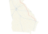
State Route 17 is a north–south route located in the U.S. state
of Georgia
. The route runs from its southern terminus at I-16
south of Bloomingdale
north to the North Carolina
border north of Hiawassee
.
. SR 17 runs north to Bloomingdale, where it begins a concurrency
with US 80
/SR 26 westward. After entering Effingham County
, SR 17 departs US 80/SR 26, and continues northwest, parallelling the Ogeechee River
through rural parts of Effingham, Screven
, and Jenkins Counties
before arriving in Millen
. After a short concurrency with SR 23 and SR 67 in Millen, SR 17 continues west, then northwest, still parallel to the Ogeechee River, to Louisville
. SR 17 overlaps US 1
/US 221
/SR 4 from Louisville north to Wrens
. In Wrens, SR 17 departs and continues to the northwest to Thomson
. In Thomson SR 17 overlaps US 78
/SR 10 north to Washington
. From Washington, SR 17 departs the concurrency with US 78/SR 10, intersects with US 378, and continues north into the mountains of northeast Georgia, first passing through Elberton
, where it intersects SR 72, then Bowman, where it intersects SR 77,and Royston
. It overlaps and intersecting Interstate 85
in Lavonia
. Southeast of Toccoa, the route turns to a westerly direction to Clarkesville
, overlapping US 123
/SR 365
in the process. Outside of Clarkesville, the continues northwest, passing through the historic Nachoochee Valley. SR 17 then begins a concurrency with SR 75. The routes travel north through the tourist town of Helen
. The two routes continue north over Unicoi Gap, then descend into the Hiawassee River valley. East of the town of Hiawassee, Georgia
, the routes begin a concurrency with US 76
/SR 2. In Hiawassee, SR 75 departs to the north. A few miles to the west, SR 17 departs US 76/SR 2, and begins a short concurrency to the north with SR 515 until they both reach their northern terminus at the North Carolina border. The road continues into North Carolina as North Carolina Highway 69
.
U.S. state
A U.S. state is any one of the 50 federated states of the United States of America that share sovereignty with the federal government. Because of this shared sovereignty, an American is a citizen both of the federal entity and of his or her state of domicile. Four states use the official title of...
of Georgia
Georgia (U.S. state)
Georgia is a state located in the southeastern United States. It was established in 1732, the last of the original Thirteen Colonies. The state is named after King George II of Great Britain. Georgia was the fourth state to ratify the United States Constitution, on January 2, 1788...
. The route runs from its southern terminus at I-16
Interstate 16
Interstate 16 , also known as Jim Gillis Historic Savannah Parkway or State Route 404 , is an intrastate Interstate Highway located entirely within the state of Georgia, United States...
south of Bloomingdale
Bloomingdale, Georgia
Bloomingdale is a city in Chatham County, Georgia, United States. The population was 2,713 at the 2010 census. It is part of the Savannah Metropolitan Statistical Area.-Geography:Bloomingdale is located at ....
north to the North Carolina
North Carolina
North Carolina is a state located in the southeastern United States. The state borders South Carolina and Georgia to the south, Tennessee to the west and Virginia to the north. North Carolina contains 100 counties. Its capital is Raleigh, and its largest city is Charlotte...
border north of Hiawassee
Hiawassee, Georgia
Hiawassee is a town in and the county seat of Towns County, Georgia, United States. The population was 810 at the 2000 census. Its name comes from the Cherokee word Ayuhwasi, which means a meadow.-Geography:...
.
Route description
State Route 17 begins at exit 152 on I-16, the westernmost exit for I-16 in Chatham CountyChatham County, Georgia
Chatham County is a county located in the U.S. state of Georgia. The county seat and largest city is Savannah. In the official US Census of 2010, Chatham County had a total population of 265,128 . Chatham is the most populous Georgia county outside the Atlanta metropolitan area...
. SR 17 runs north to Bloomingdale, where it begins a concurrency
Concurrency (road)
A concurrency, overlap, or coincidence in a road network is an instance of one physical road bearing two or more different highway, motorway, or other route numbers...
with US 80
U.S. Route 80
U.S. Route 80 is an east–west United States highway, much of which was once part of the early auto trail known as the Dixie Overland Highway. As the "0" in the route number indicates, it was originally a cross-country route, from the Atlantic to the Pacific...
/SR 26 westward. After entering Effingham County
Effingham County, Georgia
Effingham County is a county located in the U.S. state of Georgia. In the United States Census of 2000, the population was 37,535. The Census Bureau's 2008 estimate estimates that this figure has grown to 52,060. The seat of Effingham County is Springfield....
, SR 17 departs US 80/SR 26, and continues northwest, parallelling the Ogeechee River
Ogeechee River
Ogeechee River is a river in the U.S. state of Georgia. It heads at the confluence of its North and South Forks, about south-southwest of Crawfordville and flowing generally southeast to Ossabaw Sound about south of Savannah. Its largest tributary is the Canoochee River...
through rural parts of Effingham, Screven
Screven County, Georgia
Screven County is a county located in the U.S. state of Georgia. As of 2000, the population was 15,374. The 2007 Census Estimate shows a population of 15,037...
, and Jenkins Counties
Jenkins County, Georgia
Jenkins County is a county located in the U.S. state of Georgia. It was created on August 17, 1905. As of 2000, the population was 8,575. The 2007 Census Estimate shows a population of 8,595. The county seat is Millen.-Geography:...
before arriving in Millen
Millen, Georgia
Millen is a city in Jenkins County, Georgia, United States. The population was 3,492 at the 2000 census, a decline of 8.3% since 1990, during a decade in which the state's population grew by 26.4%.The city, centered near the intersection of U.S...
. After a short concurrency with SR 23 and SR 67 in Millen, SR 17 continues west, then northwest, still parallel to the Ogeechee River, to Louisville
Louisville, Georgia
Louisville is a city in Jefferson County, Georgia, United States. It is the former capital of Georgia and is the county seat of Jefferson County. It is located southwest of Augusta on the Ogeechee River, and its population was 2,712 at the 2000 census. The local pronunciation is the Americanized...
. SR 17 overlaps US 1
U.S. Route 1
U.S. Route 1 is a major north–south U.S. Highway that serves the East Coast of the United States. It runs 2,377 miles from Fort Kent, Maine at the Canadian border south to Key West, Florida. U.S. 1 generally parallels Interstate 95, though it is significantly farther west between...
/US 221
U.S. Route 221
U.S. Route 221 is a spur of U.S. Route 21. It runs for 734 miles from Perry, Florida at US Routes 19/98/ALT 27 to Lynchburg, Virginia at U.S. Route 29 . It passes through the states of Florida, Georgia, South Carolina, North Carolina, and Virginia...
/SR 4 from Louisville north to Wrens
Wrens, Georgia
Wrens is a city in Jefferson County, Georgia, United States. The population was 2,187 at the 2010 census.-Geography:Wrens is located at .According to the United States Census Bureau, the city has a total area of , of which, of it is land and 0.33% is water.-Demographics:As of the census of 2000,...
. In Wrens, SR 17 departs and continues to the northwest to Thomson
Thomson, Georgia
Thomson, incorporated February 15, 1854, is a city in McDuffie County, Georgia, United States. The population was 6,828 at the 2000 census. The city is the county seat of McDuffie County. Thomson's nickname is "The Camellia City of the South", in honor of the thousands of camellia plants...
. In Thomson SR 17 overlaps US 78
U.S. Route 78
U.S. Highway 78 is an east–west United States highway that runs for 715 miles from Memphis, Tennessee, to Charleston, South Carolina. Between Memphis and Birmingham, Alabama, it is being upgraded to become Interstate 22....
/SR 10 north to Washington
Washington, Georgia
Washington is a city in Wilkes County, Georgia, United States. The population was 4,295 at the 2000 census. The city is the county seat of Wilkes County...
. From Washington, SR 17 departs the concurrency with US 78/SR 10, intersects with US 378, and continues north into the mountains of northeast Georgia, first passing through Elberton
Elberton, Georgia
Elberton is the largest city in Elbert County, Georgia, United States. The population was 4,743 at the 2000 census. The city is the county seat of Elbert County and serves as a hub for industry and small business in Northeast Georgia...
, where it intersects SR 72, then Bowman, where it intersects SR 77,and Royston
Royston, Georgia
Royston is a city in Franklin, Hart, and Madison counties in the U.S. state of Georgia. The population was 2,493 at the 2000 census.-Geography:Royston is located at ....
. It overlaps and intersecting Interstate 85
Interstate 85
Interstate 85 is a major interstate highway in the Southeastern United States. Its current southern terminus is at an interchange with Interstate 65 in Montgomery, Alabama; its northern terminus interchanges with Interstate 95 in Petersburg, Virginia, near Richmond...
in Lavonia
Lavonia, Georgia
Lavonia is a city in Franklin County, Georgia, United States. The population was 1,827 at the 2000 census.-Geography:Lavonia is located at ....
. Southeast of Toccoa, the route turns to a westerly direction to Clarkesville
Clarkesville, Georgia
Clarkesville is a city located in the center of Habersham County, Georgia. It is also the county seat.-Geography:Clarkesville is located at ....
, overlapping US 123
U.S. Route 123
U.S. Route 123 is a spur of U.S. Route 23. It currently runs for from Greenville, South Carolina to Dicks Hill, Georgia at U.S. Route 23. It passes through the states of South Carolina and Georgia and before the construction of I-85, it was the main route between Greenville, South Carolina and...
/SR 365
State Route 365 (Georgia)
State Route 365 begins at exit 113 on Interstate 85, just north of Suwanee, Georgia. It continues from that point concurrent with Interstate 985 and U.S. Route 23 .-Major intersections:...
in the process. Outside of Clarkesville, the continues northwest, passing through the historic Nachoochee Valley. SR 17 then begins a concurrency with SR 75. The routes travel north through the tourist town of Helen
Helen, Georgia
Helen is a city located on the Chattahoochee River in White County in the north of the U.S. state of Georgia. As of the 2000 census, the city's population was 420.-History:...
. The two routes continue north over Unicoi Gap, then descend into the Hiawassee River valley. East of the town of Hiawassee, Georgia
Hiawassee, Georgia
Hiawassee is a town in and the county seat of Towns County, Georgia, United States. The population was 810 at the 2000 census. Its name comes from the Cherokee word Ayuhwasi, which means a meadow.-Geography:...
, the routes begin a concurrency with US 76
U.S. Route 76
U.S. Route 76 is an east–west United States highway that runs for from Chattanooga, Tennessee to Wrightsville Beach, North Carolina.-Tennessee:...
/SR 2. In Hiawassee, SR 75 departs to the north. A few miles to the west, SR 17 departs US 76/SR 2, and begins a short concurrency to the north with SR 515 until they both reach their northern terminus at the North Carolina border. The road continues into North Carolina as North Carolina Highway 69
North Carolina Highway 69
NC 69 is a short north/south state highway in western North Carolina; it is entirely in Clay County.-Route description:NC 69 runs from the Georgia border south of Hayesville north, along the western shore of Lake Chatuge. The route crosses U.S. Route 64 before entering downtown Hayesville, where it...
.
Banner Routes
State Route 17 has four banner routes:- State Route 17 Alternate. SR 17 Alternate runs west from its parent route in Clarkesville to meet it again southeast of Toccoa. The route follows a former alignment of SR 17.
- State Route 17 Business
- State Route 17 Bypass
- State Route 17 Connector