

Wilcox County, Alabama
Encyclopedia
Wilcox County is a county
of the U.S. state
of Alabama
. Its name is in honor of Lieutenant J. M. Wilcox, who fought in the wars against the Creek tribe. As of 2010, the population was 11,670. Its county seat
is Camden
.
of 2000, there were 13,183 people, 4,776 households, and 3,376 families residing in the county. The population density
was 15 people per square mile (6/km2). There were 6,183 housing units at an average density of 7 per square mile (3/km2). The racial makeup of the county was 71.90% Black
or African American
, 27.51% White
, 0.14% Native American
, 0.13% Asian
, 0.02% Pacific Islander
, 0.11% from other races
, and 0.19% from two or more races. Nearly 0.74% of the population were Hispanic
or Latino
of any race.
There were 4,776 households out of which 36.00% had children under the age of 18 living with them, 39.80% were married couples
living together, 26.50% had a female householder with no husband present, and 29.30% were non-families. Nearly 27.50% of all households were made up of individuals, and 11.90% had someone living alone who was 65 years of age or older. The average household size was 2.70, and the average family size was 3.31.
In the county, the population was spread out with 30.70% under the age of 18, 9.10% from 18 to 24, 25.50% from 25 to 44, 21.00% from 45 to 64, and 13.70% who were 65 years of age or older. The median age was 34 years. For every 100 females, there were 87.20 males. For every 100 females age 18 and over, there were 81.00 males.
The median income for a household in the county was $16,646, and the median income for a family was $22,200. Males had a median income of $26,216 versus $17,274 for females. The per capita income
for the county was $10,903. About 36.10% of families and 39.90% of the population were below the poverty line, including 48.40% of those under age 18 and 32.10% of those age 65 or over.
, Lake Dannelly, and Bridgeport Beach.
County (United States)
In the United States, a county is a geographic subdivision of a state , usually assigned some governmental authority. The term "county" is used in 48 of the 50 states; Louisiana is divided into parishes and Alaska into boroughs. Parishes and boroughs are called "county-equivalents" by the U.S...
of the U.S. state
U.S. state
A U.S. state is any one of the 50 federated states of the United States of America that share sovereignty with the federal government. Because of this shared sovereignty, an American is a citizen both of the federal entity and of his or her state of domicile. Four states use the official title of...
of Alabama
Alabama
Alabama is a state located in the southeastern region of the United States. It is bordered by Tennessee to the north, Georgia to the east, Florida and the Gulf of Mexico to the south, and Mississippi to the west. Alabama ranks 30th in total land area and ranks second in the size of its inland...
. Its name is in honor of Lieutenant J. M. Wilcox, who fought in the wars against the Creek tribe. As of 2010, the population was 11,670. Its county seat
County seat
A county seat is an administrative center, or seat of government, for a county or civil parish. The term is primarily used in the United States....
is Camden
Camden, Alabama
Camden is a city in Wilcox County, Alabama, United States. The population was 2,257 at the 2000 census, at which time it was a town.-Geography:Camden is located at ....
.
Geography
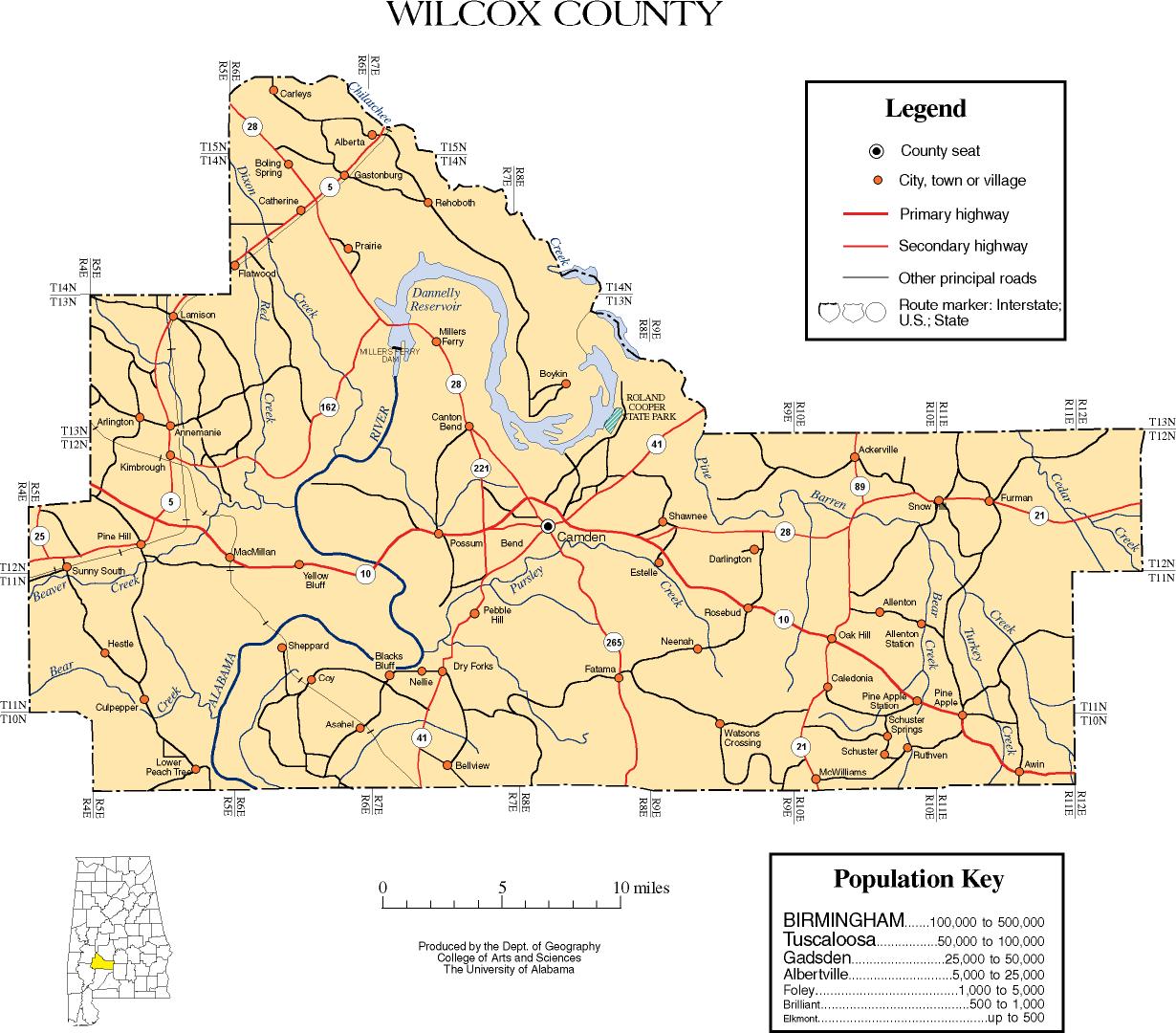
According to the 2000 census, the county has a total area of 907.46 square miles (2,350.3 km²), of which 888.68 square miles (2,301.7 km²) (or 97.93%) is land and 18.78 square miles (48.6 km²) (or 2.07%) is water.Major highways
 State Route 5State Route 5 (Alabama)State Route 5 is a north–south state highway is the western part of the State of Alabama. While it once extended—prior to the renumbering of the highways of Alabama in 1957—from Mobile north to Tennessee, and was one of the major routes between Mobile and Birmingham, it has since been...
 State Route 10
 State Route 21State Route 21 (Alabama)State Route 21 is a state highway that extends from Piedmont in Calhoun County to the Florida state line near Atmore in Escambia County. The route runs almost the entire length of the state from the northeast to the southwest.-Route description:...
 State Route 28
 State Route 41
 State Route 89
Adjacent counties
- Dallas CountyDallas County, AlabamaDallas County is a county of the U.S. state of Alabama. Its name is in honor of United States Secretary of the Treasury Alexander J. Dallas. The county seat is Selma.- History :...
(northeast) - Lowndes CountyLowndes County, AlabamaLowndes County is a county of the U.S. state of Alabama. It is named in honor of William Lowndes, a member of the United States Congress from South Carolina. As of the 2010 census, the population was 11,299...
(east-northeast) - Butler CountyButler County, AlabamaButler County is a county of the U.S. state of Alabama. Its name is in honor of Captain William Butler, who was born in Virginia and fought in the Creek War, and who was killed in May 1818. As of 2010 the population was 20,947...
(east-southeast) - Monroe CountyMonroe County, AlabamaMonroe County is a county of the U.S. state of Alabama. Its name is in honor of James Monroe, fifth President of the United States. As of 2010, the population was 23,068. Its county seat is Monroeville. It is a dry county, in which the sale of alcoholic beverages is restricted or...
(south) - Clarke CountyClarke County, Alabama-2010:Whereas according to the 2010 U.S. Census Bureau:*54.5% White*43.9% Black*0.4% Native American*0.3% Asian*0.0% Native Hawaiian or Pacific Islander*0.7% Two or more races*1.0% Hispanic or Latino -2000:...
(southwest) - Marengo CountyMarengo County, AlabamaMarengo County is a county of the U.S. state of Alabama. It is named in honor of a battlefield near Turin, Italy, where the French defeated the Austrians on June 14, 1800. As of 2010 the population was 21,027...
(northwest)
Demographics
As of the censusCensus
A census is the procedure of systematically acquiring and recording information about the members of a given population. It is a regularly occurring and official count of a particular population. The term is used mostly in connection with national population and housing censuses; other common...
of 2000, there were 13,183 people, 4,776 households, and 3,376 families residing in the county. The population density
Population density
Population density is a measurement of population per unit area or unit volume. It is frequently applied to living organisms, and particularly to humans...
was 15 people per square mile (6/km2). There were 6,183 housing units at an average density of 7 per square mile (3/km2). The racial makeup of the county was 71.90% Black
Race (United States Census)
Race and ethnicity in the United States Census, as defined by the Federal Office of Management and Budget and the United States Census Bureau, are self-identification data items in which residents choose the race or races with which they most closely identify, and indicate whether or not they are...
or African American
Race (United States Census)
Race and ethnicity in the United States Census, as defined by the Federal Office of Management and Budget and the United States Census Bureau, are self-identification data items in which residents choose the race or races with which they most closely identify, and indicate whether or not they are...
, 27.51% White
Race (United States Census)
Race and ethnicity in the United States Census, as defined by the Federal Office of Management and Budget and the United States Census Bureau, are self-identification data items in which residents choose the race or races with which they most closely identify, and indicate whether or not they are...
, 0.14% Native American
Race (United States Census)
Race and ethnicity in the United States Census, as defined by the Federal Office of Management and Budget and the United States Census Bureau, are self-identification data items in which residents choose the race or races with which they most closely identify, and indicate whether or not they are...
, 0.13% Asian
Race (United States Census)
Race and ethnicity in the United States Census, as defined by the Federal Office of Management and Budget and the United States Census Bureau, are self-identification data items in which residents choose the race or races with which they most closely identify, and indicate whether or not they are...
, 0.02% Pacific Islander
Race (United States Census)
Race and ethnicity in the United States Census, as defined by the Federal Office of Management and Budget and the United States Census Bureau, are self-identification data items in which residents choose the race or races with which they most closely identify, and indicate whether or not they are...
, 0.11% from other races
Race (United States Census)
Race and ethnicity in the United States Census, as defined by the Federal Office of Management and Budget and the United States Census Bureau, are self-identification data items in which residents choose the race or races with which they most closely identify, and indicate whether or not they are...
, and 0.19% from two or more races. Nearly 0.74% of the population were Hispanic
Race (United States Census)
Race and ethnicity in the United States Census, as defined by the Federal Office of Management and Budget and the United States Census Bureau, are self-identification data items in which residents choose the race or races with which they most closely identify, and indicate whether or not they are...
or Latino
Race (United States Census)
Race and ethnicity in the United States Census, as defined by the Federal Office of Management and Budget and the United States Census Bureau, are self-identification data items in which residents choose the race or races with which they most closely identify, and indicate whether or not they are...
of any race.
There were 4,776 households out of which 36.00% had children under the age of 18 living with them, 39.80% were married couples
Marriage
Marriage is a social union or legal contract between people that creates kinship. It is an institution in which interpersonal relationships, usually intimate and sexual, are acknowledged in a variety of ways, depending on the culture or subculture in which it is found...
living together, 26.50% had a female householder with no husband present, and 29.30% were non-families. Nearly 27.50% of all households were made up of individuals, and 11.90% had someone living alone who was 65 years of age or older. The average household size was 2.70, and the average family size was 3.31.
In the county, the population was spread out with 30.70% under the age of 18, 9.10% from 18 to 24, 25.50% from 25 to 44, 21.00% from 45 to 64, and 13.70% who were 65 years of age or older. The median age was 34 years. For every 100 females, there were 87.20 males. For every 100 females age 18 and over, there were 81.00 males.
The median income for a household in the county was $16,646, and the median income for a family was $22,200. Males had a median income of $26,216 versus $17,274 for females. The per capita income
Per capita income
Per capita income or income per person is a measure of mean income within an economic aggregate, such as a country or city. It is calculated by taking a measure of all sources of income in the aggregate and dividing it by the total population...
for the county was $10,903. About 36.10% of families and 39.90% of the population were below the poverty line, including 48.40% of those under age 18 and 32.10% of those age 65 or over.
Towns
- Oak HillOak Hill, AlabamaOak Hill is a town in Wilcox County, Alabama, United States. The population was 37 at the 2000 census. Benjamin M. Miller, Governor of Alabama from 1931 to 1935, was born at Oak Hill on March 13, 1864.-Geography:...
- Pine ApplePine Apple, Alabama“Pine Apple” redirects here. For the fruit, see PineapplePine Apple is a town in Wilcox County, Alabama, United States. At the 2000 census the population was 145...
- Pine HillPine Hill, AlabamaPine Hill is a town in Wilcox County, Alabama, United States. As of the 2000 census, the population of the town is 966.-Geography:Pine Hill is located at .According to the U.S...
- Yellow BluffYellow Bluff, AlabamaYellow Bluff is a town in Wilcox County, Alabama, United States. At the 2000 census the population was 181.-Geography:Yellow Bluff is located at .According to the U.S...
Unincorporated communities
- AckervilleAckerville, AlabamaAckerville is an unincorporated community in Wilcox County, Alabama, United States. Ackerville has one site included on the National Register of Historic Places, the Ackerville Baptist Church of Christ.-Geography:...
- AlbertaAlberta, AlabamaAlberta is an unincorporated community in Wilcox County, Alabama, United States.-Geography:Alberta is located at and has an elevation of ....
- Anne ManieAnne Manie, AlabamaAnne Manie, sometimes spelled Annemanie, is an unincorporated community in Wilcox County, Alabama, United States. The community had a post office, with postmasters appointed from 1924 to 1964.-Geography:...
- ArlingtonArlington, AlabamaArlington, originally known as Dumas Store, is an unincorporated community in Wilcox County, Alabama, United States.-Geography:Arlington is located at and has an elevation of ....
- Canton BendCanton Bend, AlabamaCanton Bend, once known simply as Canton, is an unincorporated community in Wilcox County, Alabama, United States. Located on the south bank of the Alabama River, it served as the first county seat for Wilcox County prior to its removal to Camden....
- CatherineCatherine, AlabamaCatherine is an unincorporated community and census-designated place in Wilcox County, Alabama, United States. As of the 2010 census, its population was 22.-Geography:Catherine is located at and has an elevation of ....
- CoyCoy, AlabamaCoy is an unincorporated community in Wilcox County, Alabama, United States. Coy is located in a bend of the Alabama River and is home to several historic plantations. The most notable of these is Dry Fork Plantation, included on the National Register of Historic Places.-Geography:Coy is located...
- FurmanFurman, AlabamaFurman, also known as Old Snow Hill, is an unincorporated community in Wilcox County, Alabama, United States. The Furman Historic District is included on the National Register of Historic Places.-Geography:...
- Gee's BendGee's Bend, AlabamaBoykin, also known as Gee's Bend, is an African American majority community and census-designated place in a large bend of the Alabama River in Wilcox County, Alabama. As of the 2010 census, its population was 275...
- Lower Peach TreeLower Peach Tree, AlabamaLower Peach Tree is an unincorporated community in Wilcox County, Alabama, United States. Lower Peach Tree is the oldest European settlement in the county. Due to its proximity to the Alabama River, Lower Peach Tree was a major cotton shipping port during the 19th century. As of 2010, only the...
- McWilliamsMcWilliams, AlabamaMcWilliams is an unincorporated community in Wilcox County, Alabama, United States.-Geography:McWilliams is located at and has an elevation of ....
- Millers FerryMillers Ferry, AlabamaMillers Ferry is an unincorporated community in Wilcox County, Alabama, United States. The Millers Ferry Lock and Dam is located near the community on the Alabama River.-Geography:Millers Ferry is located at and its elevation is .-Tornadoes:...
- Snow HillSnow Hill, AlabamaSnow Hill is an unincorporated community in Wilcox County, Alabama, United States. Snow Hill has one site included on the National Register of Historic Places, the Snow Hill Normal and Industrial Institute.-Geography:...
Places of interest
Wilcox County is home to Roland Cooper State ParkRoland Cooper State Park
Roland Cooper State Park is a state park in Wilcox County, Alabama. It is located six miles northeast of Camden, along the William "Bill" Dannelly Reservoir.-Amenities:The park features a nine hole golf course with a clubhouse...
, Lake Dannelly, and Bridgeport Beach.
See also
- National Register of Historic Places listings in Wilcox County, Alabama
- Properties on the Alabama Register of Landmarks and Heritage in Wilcox County, Alabama
External links
- Wilcox County map of roads/towns (map © 2007 Univ. of AlabamaUniversity of AlabamaThe University of Alabama is a public coeducational university located in Tuscaloosa, Alabama, United States....
).