
Kastamonu Province
Encyclopedia
Kastamonu Province is one of the provinces of Turkey, in the Black Sea region, to the north of the country. It is surrounded by Sinop
to the east, Bartın
and Karabük
to the west, Çankırı
to the south, Çorum
to the south east and the Black Sea
to the north.
(capital district in bold):
refer to the province. There are also some archeological findings dating back to about 100,000 years that suggest the region was inhabited then.
There are theories that the word Kastamonu derives from Castra Comnenus, the Latin name of the Byzantine
castle built by the Comnenus dynasty.
With the weakening of the Macedon
kings, the whole Paphlagonia
and Bithynia
regions were engulfed by the newly formed Pontus
kingdom. After the fall of the Pontus kingdom in first century BC, the area was incorporated by the Roman Empire
by joining Paphlagonia with Bithynia. The capitol center of this new city-state was Pompeiopolis
, of which the remains still stand near Taşköprü
District in Kastamonu.
The region went then under the hegemony of the Seljuq dynasty 11th century CE
, followed by the Danishmends, the Byzantine
s during the crusades, Çobanoğlu and Jandarid beyliks. The Ottoman
sultan
Beyazid I conquered the province in 1392 however, following his capture and death in Battle of Ankara
, the area was granted back to the Çandaroğlu by the Mongol warlord Timur Lenk. Ottoman sultan Mehmed II
incorporated the region back to the empire in 1461.
During the Ottoman reign, the province boundaries were expanded up to reach Constantinople
. The sultan's heirs were often sent to rule the province as governors to gain experience.
After the First World War, during the battles of the Turkish War of Independence
, Kastamonu played an important role in the supply of ammunition and troops to the İnebolu
–Ankara
front, transporting the war machines that would arrive to İnebolu by sea from Constantinople
and the Soviets
. When the Greeks
noticed this activity, the İnebolu port was bombarded from the sea on 9 June 1921.
 The province is mostly covered with forests, thanks to the mild Black Sea climate. The Ilgaz National Park where a micro-climate dominates due to the mountainous terrain and numerous streams is 63 km south the province center Kastamonu
. There is also a ski-center with accommodation facilities located near the park.
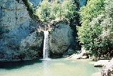
Ilgaz Mountain (highest peak 2587 m) dominates the south of the province where hiking and whitewater
rafting
is possible at the Ilgaz Stream. The Ilgarini cave at Cide
, the Alinca underground cave at Küre, and the International Equestrian Tourism Center of Daday
are other attractions worth seeing.
There's a 12th-century Byzantine castle, the 13th-century Atabey Mosque and the Ibni Neccar Mosque also located in the province. The Mahmut Bey Mosque, located in the village of Kasaba is known for its elegant wood carvings.
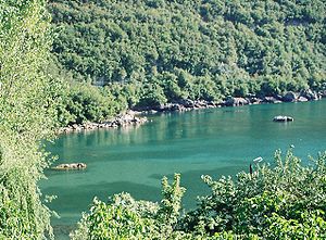
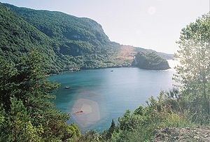
Gideros Bay,13 km to Cide is a holiday resort with pensions and fish restaurants.
 The ruins of the Roman city-state Pompeiopolis
are found near Taşköprü.
Kastamonu also has many mansions, which are traditionally built with an architectural style unique to this region. Many of these mansions have been restored following a declaration by the local government in 2000, in order to preserve the historical texture.
Almost all of the arable land has permanent crops. The agricultural products make up about of 0,01% of the total in Turkey. A large portion of the agricultural produce consists of cereals. Thanks to its wide forest areas (a total of 57% of the surface area), forestry
is also an important industry. Industries largely consist of manufacturing of forestry, agriculture and mining products.
Underground resources include copper, mercury
, iron ore, chromium, manganese
, asbestos
, bauxite
, graphite
, phosphate
, kaolinite
, clay
, limestone
, quartz
, marble
, magnesite
, fire clay
, coal and nickel. There are also some natural thermal and mineral water springs of which a few are suitable for economic investments.
Kastamonu shares about 0.4% of the GDP, the composition of the GDP is as follows:
agriculture: 32.8%
communication and transport 20%
services: 16.8%
industry: 9.5% (1998 est.)
Transportation is possible only through paved and unpaved highways; a railroad that will connect Çankırı, Kastamonu and İnebolu is under construction. Although the province has a 135 km long coastline to Black Sea, only İnebolu has a small port and transportation by the sea is almost non-existent.
There are around 112,000 telephone main lines in use, about 200,000 cellphone subscribers and 15,000 Internet users in the province.
Sinop Province
Sinop Province is a province of Turkey, along the Black Sea. It is located between 41 and 42 degrees North latitude and between 34 and 35 degrees East longitude. The surface area is 5,862 km², equivalent to 0.8% of Turkey's surface area. The borders total 475 km and consists of 300 km of land and...
to the east, Bartın
Bartin Province
Bartın Province is a small province in northern Turkey on the Black Sea, surrounding the city of Bartın. It is to the east from Zonguldak Province.The town of Bartın contains a number of very old wooden houses which are no longer extant in other places....
and Karabük
Karabük Province
Karabük Province is a province in northern central Turkey with a total population of 227,610 .The main city is Karabük which is located about 200 km north of Ankara and about 100 km south of the Black Sea coast...
to the west, Çankırı
Çankiri Province
Çankırı Province is a province of Turkey, which lies close to the capital, Ankara. The provincial capital is Çankırı.-Economy:Çankırı is primarily agricultural with wheat, beans, corn and tomatoes the most common crops.-Climate:...
to the south, Çorum
Çorum Province
Çorum Province is a province in the Black Sea Region of Turkey, but lying inland and having more characteristics of Central Anatolia than the Black Sea coast....
to the south east and the Black Sea
Black Sea
The Black Sea is bounded by Europe, Anatolia and the Caucasus and is ultimately connected to the Atlantic Ocean via the Mediterranean and the Aegean seas and various straits. The Bosphorus strait connects it to the Sea of Marmara, and the strait of the Dardanelles connects that sea to the Aegean...
to the north.
Statistics
The province has an area of 13,108 km², and a population of 322,759 people (2006 est). The population was 361,222 people in 2010. The population density is 24.62 inhabitants per km². The province center has a population of 64,606.Districts
Kastamonu province is divided into 20 districtsDistricts of Turkey
The 81 provinces of Turkey are divided into 957 districts . In the early Turkish Republic and in the Ottoman Empire, the corresponding unit was the kaza....
(capital district in bold):
|
|
History
It is not definitely known when Kastamonu was first founded. However, some sources dating back to the Early Middle AgesMiddle Ages
The Middle Ages is a periodization of European history from the 5th century to the 15th century. The Middle Ages follows the fall of the Western Roman Empire in 476 and precedes the Early Modern Era. It is the middle period of a three-period division of Western history: Classic, Medieval and Modern...
refer to the province. There are also some archeological findings dating back to about 100,000 years that suggest the region was inhabited then.
There are theories that the word Kastamonu derives from Castra Comnenus, the Latin name of the Byzantine
Byzantine Empire
The Byzantine Empire was the Eastern Roman Empire during the periods of Late Antiquity and the Middle Ages, centred on the capital of Constantinople. Known simply as the Roman Empire or Romania to its inhabitants and neighbours, the Empire was the direct continuation of the Ancient Roman State...
castle built by the Comnenus dynasty.
With the weakening of the Macedon
Macedon
Macedonia or Macedon was an ancient kingdom, centered in the northeastern part of the Greek peninsula, bordered by Epirus to the west, Paeonia to the north, the region of Thrace to the east and Thessaly to the south....
kings, the whole Paphlagonia
Paphlagonia
Paphlagonia was an ancient area on the Black Sea coast of north central Anatolia, situated between Bithynia to the west and Pontus to the east, and separated from Phrygia by a prolongation to the east of the Bithynian Olympus...
and Bithynia
Bithynia
Bithynia was an ancient region, kingdom and Roman province in the northwest of Asia Minor, adjoining the Propontis, the Thracian Bosporus and the Euxine .-Description:...
regions were engulfed by the newly formed Pontus
Pontus
Pontus or Pontos is a historical Greek designation for a region on the southern coast of the Black Sea, located in modern-day northeastern Turkey. The name was applied to the coastal region in antiquity by the Greeks who colonized the area, and derived from the Greek name of the Black Sea: Πόντος...
kingdom. After the fall of the Pontus kingdom in first century BC, the area was incorporated by the Roman Empire
Roman Empire
The Roman Empire was the post-Republican period of the ancient Roman civilization, characterised by an autocratic form of government and large territorial holdings in Europe and around the Mediterranean....
by joining Paphlagonia with Bithynia. The capitol center of this new city-state was Pompeiopolis
Pompeiopolis
Pompeiopolis was a Roman city-state in ancient Paphlagonia, situated today in the Taşköprü district, Kastamonu, Turkey. The exact location is 45 km north of Kastamonu, to the north of Taşköprü, in the valley of the Gökırmak...
, of which the remains still stand near Taşköprü
Tasköprü
Taşköprü is a town and district of Kastamonu Province in the Black Sea region of Turkey. According to the 2000 census, population of the district is 43,800 of which 16,181 live in the town of Taşköprü. The district covers an area of , and the town lies at an elevation of .The town takes its name...
District in Kastamonu.
The region went then under the hegemony of the Seljuq dynasty 11th century CE
Common Era
Common Era ,abbreviated as CE, is an alternative designation for the calendar era originally introduced by Dionysius Exiguus in the 6th century, traditionally identified with Anno Domini .Dates before the year 1 CE are indicated by the usage of BCE, short for Before the Common Era Common Era...
, followed by the Danishmends, the Byzantine
Byzantine Empire
The Byzantine Empire was the Eastern Roman Empire during the periods of Late Antiquity and the Middle Ages, centred on the capital of Constantinople. Known simply as the Roman Empire or Romania to its inhabitants and neighbours, the Empire was the direct continuation of the Ancient Roman State...
s during the crusades, Çobanoğlu and Jandarid beyliks. The Ottoman
Ottoman Empire
The Ottoman EmpireIt was usually referred to as the "Ottoman Empire", the "Turkish Empire", the "Ottoman Caliphate" or more commonly "Turkey" by its contemporaries...
sultan
Sultan
Sultan is a title with several historical meanings. Originally, it was an Arabic language abstract noun meaning "strength", "authority", "rulership", and "dictatorship", derived from the masdar سلطة , meaning "authority" or "power". Later, it came to be used as the title of certain rulers who...
Beyazid I conquered the province in 1392 however, following his capture and death in Battle of Ankara
Battle of Ankara
The Battle of Ankara or Battle of Angora, fought on July 20, 1402, took place at the field of Çubuk between the forces of the Ottoman sultan Bayezid I and the Turko-Mongol forces of Timur, ruler of the Timurid Empire. The battle was a major victory for Timur, and it led to a period of crisis for...
, the area was granted back to the Çandaroğlu by the Mongol warlord Timur Lenk. Ottoman sultan Mehmed II
Mehmed II
Mehmed II , was Sultan of the Ottoman Empire for a short time from 1444 to September 1446, and later from...
incorporated the region back to the empire in 1461.
During the Ottoman reign, the province boundaries were expanded up to reach Constantinople
Istanbul
Istanbul , historically known as Byzantium and Constantinople , is the largest city of Turkey. Istanbul metropolitan province had 13.26 million people living in it as of December, 2010, which is 18% of Turkey's population and the 3rd largest metropolitan area in Europe after London and...
. The sultan's heirs were often sent to rule the province as governors to gain experience.
After the First World War, during the battles of the Turkish War of Independence
Turkish War of Independence
The Turkish War of Independence was a war of independence waged by Turkish nationalists against the Allies, after the country was partitioned by the Allies following the Ottoman Empire's defeat in World War I...
, Kastamonu played an important role in the supply of ammunition and troops to the İnebolu
Inebolu
İnebolu is a town and district of the Kastamonu Province in the Black Sea region of Turkey. It is from Istanbul by road and north of Kastamonu. It is a typical Black Sea port town with many fine examples of traditional domestic architecture. According to the 2000 census, population of the...
–Ankara
Ankara
Ankara is the capital of Turkey and the country's second largest city after Istanbul. The city has a mean elevation of , and as of 2010 the metropolitan area in the entire Ankara Province had a population of 4.4 million....
front, transporting the war machines that would arrive to İnebolu by sea from Constantinople
Istanbul
Istanbul , historically known as Byzantium and Constantinople , is the largest city of Turkey. Istanbul metropolitan province had 13.26 million people living in it as of December, 2010, which is 18% of Turkey's population and the 3rd largest metropolitan area in Europe after London and...
and the Soviets
Soviet Union
The Soviet Union , officially the Union of Soviet Socialist Republics , was a constitutionally socialist state that existed in Eurasia between 1922 and 1991....
. When the Greeks
Greco-Turkish War (1919-1922)
The Greco–Turkish War of 1919–1922, known as the Western Front of the Turkish War of Independence in Turkey and the Asia Minor Campaign or the Asia Minor Catastrophe in Greece, was a series of military events occurring during the partitioning of the Ottoman Empire after World War I between May...
noticed this activity, the İnebolu port was bombarded from the sea on 9 June 1921.
Highlights
Kastamonu
Kastamonu is the capital district of the Kastamonu Province, Turkey. According to the 2000 census, population of the district is 102,059 of which 64,606 live in the urban center of Kastamonu. The district covers an area of , and the town lies at an elevation of...
. There is also a ski-center with accommodation facilities located near the park.
Ilgaz Mountain (highest peak 2587 m) dominates the south of the province where hiking and whitewater
Whitewater
Whitewater is formed in a rapid, when a river's gradient increases enough to disturb its laminar flow and create turbulence, i.e. form a bubbly, or aerated and unstable current; the frothy water appears white...
rafting
Rafting
Rafting or white water rafting is a challenging recreational outdoor activity using an inflatable raft to navigate a river or other bodies of water. This is usually done on white water or different degrees of rough water, in order to thrill and excite the raft passengers. The development of this...
is possible at the Ilgaz Stream. The Ilgarini cave at Cide
Cide
Cide, also Karaağaç, is a town and district of the Kastamonu Province in the Black Sea region of Turkey. According to the 2000 census, population of the district is 23,161 of which 5,834 live in the town of Cide. The district covers an area of , and the town lies at an elevation of .-External links:*...
, the Alinca underground cave at Küre, and the International Equestrian Tourism Center of Daday
Daday
Daday is a town and district of the Kastamonu Province in the Black Sea region of Turkey. It is located at 30 km west of Kastamonu. According to the 2000 census, population of the district is 11,181 of which 4,625 live in the town of Daday. The district covers an area of , and the town lies at an...
are other attractions worth seeing.
There's a 12th-century Byzantine castle, the 13th-century Atabey Mosque and the Ibni Neccar Mosque also located in the province. The Mahmut Bey Mosque, located in the village of Kasaba is known for its elegant wood carvings.
Gideros Bay,13 km to Cide is a holiday resort with pensions and fish restaurants.
Pompeiopolis
Pompeiopolis was a Roman city-state in ancient Paphlagonia, situated today in the Taşköprü district, Kastamonu, Turkey. The exact location is 45 km north of Kastamonu, to the north of Taşköprü, in the valley of the Gökırmak...
are found near Taşköprü.
Kastamonu also has many mansions, which are traditionally built with an architectural style unique to this region. Many of these mansions have been restored following a declaration by the local government in 2000, in order to preserve the historical texture.
Economy
According to the 2000 census, 77.5% of the labor force is occupied in agriculture. This ratio is higher than the country average. The second largest sector is public and private services (8.9%).Almost all of the arable land has permanent crops. The agricultural products make up about of 0,01% of the total in Turkey. A large portion of the agricultural produce consists of cereals. Thanks to its wide forest areas (a total of 57% of the surface area), forestry
Forestry
Forestry is the interdisciplinary profession embracing the science, art, and craft of creating, managing, using, and conserving forests and associated resources in a sustainable manner to meet desired goals, needs, and values for human benefit. Forestry is practiced in plantations and natural stands...
is also an important industry. Industries largely consist of manufacturing of forestry, agriculture and mining products.
Underground resources include copper, mercury
Mercury (element)
Mercury is a chemical element with the symbol Hg and atomic number 80. It is also known as quicksilver or hydrargyrum...
, iron ore, chromium, manganese
Manganese
Manganese is a chemical element, designated by the symbol Mn. It has the atomic number 25. It is found as a free element in nature , and in many minerals...
, asbestos
Asbestos
Asbestos is a set of six naturally occurring silicate minerals used commercially for their desirable physical properties. They all have in common their eponymous, asbestiform habit: long, thin fibrous crystals...
, bauxite
Bauxite
Bauxite is an aluminium ore and is the main source of aluminium. This form of rock consists mostly of the minerals gibbsite Al3, boehmite γ-AlO, and diaspore α-AlO, in a mixture with the two iron oxides goethite and hematite, the clay mineral kaolinite, and small amounts of anatase TiO2...
, graphite
Graphite
The mineral graphite is one of the allotropes of carbon. It was named by Abraham Gottlob Werner in 1789 from the Ancient Greek γράφω , "to draw/write", for its use in pencils, where it is commonly called lead . Unlike diamond , graphite is an electrical conductor, a semimetal...
, phosphate
Phosphate
A phosphate, an inorganic chemical, is a salt of phosphoric acid. In organic chemistry, a phosphate, or organophosphate, is an ester of phosphoric acid. Organic phosphates are important in biochemistry and biogeochemistry or ecology. Inorganic phosphates are mined to obtain phosphorus for use in...
, kaolinite
Kaolinite
Kaolinite is a clay mineral, part of the group of industrial minerals, with the chemical composition Al2Si2O54. It is a layered silicate mineral, with one tetrahedral sheet linked through oxygen atoms to one octahedral sheet of alumina octahedra...
, clay
Clay
Clay is a general term including many combinations of one or more clay minerals with traces of metal oxides and organic matter. Geologic clay deposits are mostly composed of phyllosilicate minerals containing variable amounts of water trapped in the mineral structure.- Formation :Clay minerals...
, limestone
Limestone
Limestone is a sedimentary rock composed largely of the minerals calcite and aragonite, which are different crystal forms of calcium carbonate . Many limestones are composed from skeletal fragments of marine organisms such as coral or foraminifera....
, quartz
Quartz
Quartz is the second-most-abundant mineral in the Earth's continental crust, after feldspar. It is made up of a continuous framework of SiO4 silicon–oxygen tetrahedra, with each oxygen being shared between two tetrahedra, giving an overall formula SiO2. There are many different varieties of quartz,...
, marble
Marble
Marble is a metamorphic rock composed of recrystallized carbonate minerals, most commonly calcite or dolomite.Geologists use the term "marble" to refer to metamorphosed limestone; however stonemasons use the term more broadly to encompass unmetamorphosed limestone.Marble is commonly used for...
, magnesite
Magnesite
Magnesite is magnesium carbonate, MgCO3. Iron substitutes for magnesium with a complete solution series with siderite, FeCO3. Calcium, manganese, cobalt, and nickel may also occur in small amounts...
, fire clay
Fire clay
Fire clay is a term applied to a range of refractory clays used in the manufacture of ceramics, especially fire brick.High grade fire clays can withstand temperatures of 1775°C , but to be referred to as a "fire clay" the material must withstand a minimum temperature of 1515°C...
, coal and nickel. There are also some natural thermal and mineral water springs of which a few are suitable for economic investments.
Kastamonu shares about 0.4% of the GDP, the composition of the GDP is as follows:
agriculture: 32.8%
communication and transport 20%
services: 16.8%
industry: 9.5% (1998 est.)
Transportation is possible only through paved and unpaved highways; a railroad that will connect Çankırı, Kastamonu and İnebolu is under construction. Although the province has a 135 km long coastline to Black Sea, only İnebolu has a small port and transportation by the sea is almost non-existent.
There are around 112,000 telephone main lines in use, about 200,000 cellphone subscribers and 15,000 Internet users in the province.
Miscellaneous
- Handcrafts are abundant in Kastamonu, especially in rural areas. Most available are hand-woven textiles.
- Several national and local annual festivities also take place in the province.
- In a research conducted in the province, 812 different food are identified that are specific to the region.
- The provincial soccer team Kastamonuspor competes in the Bank Asya 1st League (1st National Soccer League).
- The founder of the Turkish republic, Atatürk had declared the "dress code reform", which abolished the fezFez (clothing)The fez , or tarboosh is a felt hat either in the shape of a red truncated cone or in the shape of a short cylinder made of kilim fabric. Both usually have tassels...
, in Kastamonu in 1925.