
Çorum Province
Encyclopedia
Çorum Province is a province in the Black Sea Region
of Turkey
, but lying inland and having more characteristics of Central Anatolia than the Black Sea coast.
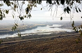
With important archaeological sites going back 5,000 years and a unique natural beauty, Çorum is attractive to visitors.

 Excavations reveal that Çorum area was inhabited during the Paleolithic, Neolithic period and the 4th stage of the Calcolithic Age. Remains of these periods have been found at Büyük Güllüce, Eskiyapar and Kuşsaray.
In later times Çorum and its environs were dominated by Hittites
and in the district of Boğazkale
is one of the most important Hittite sites in Anatolia, the UNESCO World Heritage listed Hattusa
, the capital of the Hittite Empire from 1700 BC to 1200 BC. Other important Hittite site include the open-air temples at Yazılıkaya
and Alacahöyük; royal tombs; and the excavations of Boğazköy including tablets proving tradings links between the Hittites and the Ancient Egyptians.
Then came the other civilizations: Phrygians, who left remains at Pazarlı, north of Çorum;
Then Cimmerians
, Medes
, Persians
, Galatia
ns, Romans, Byzantines
, Seljuk Turks, Danishmends
, Mongol Empire
(Ilkhanids), Eretnids, Kadi Burhan al-Din
and finally the Ottoman Empire
. As well as the Hittite archaeology the province also contains a number of castles, bridges and mosques from the Seljuk and Ottoman periods.
Black Sea Region
The Black Sea Region is one of Turkey's seven census-defined geographical regions . It is bordered by the Marmara Region to the west, the Central Anatolia Region to the south, the Eastern Anatolia Region to the southeast, the Republic of Georgia to the northeast, and the Black Sea to the north.-...
of Turkey
Turkey
Turkey , known officially as the Republic of Turkey , is a Eurasian country located in Western Asia and in East Thrace in Southeastern Europe...
, but lying inland and having more characteristics of Central Anatolia than the Black Sea coast.
With important archaeological sites going back 5,000 years and a unique natural beauty, Çorum is attractive to visitors.
Geography
The province of Çorum is a mixture of mountains and high plateaus, some of it watered by the Kızılırmak and Yeşilırmak rivers. The province includes much attractive high meadow and mountain for walking and excursions from the city and towns.| Month | Jan | Feb | Mar | Apr | May | Jun | Jul | Aug | Sep | Oct | Nov | Dec | |
|---|---|---|---|---|---|---|---|---|---|---|---|---|---|
| Average high °C | 4.2 | 6.5 | 11.5 | 17.4 | 21.8 | 25.6 | 28.9 | 29.1 | 25.6 | 19.5 | 12.1 | 6.0 | |
| Ave. low °C | -4.3 | -3.8 | -1.1 | 3.7 | 7.0 | 9.8 | 12.1 | 12.0 | 8.7 | 4.7 | 0.3 | -2.3 | |
| source: www.meteor.gov.tr | |||||||||||||
History
In later times Çorum and its environs were dominated by Hittites
Hittites
The Hittites were a Bronze Age people of Anatolia.They established a kingdom centered at Hattusa in north-central Anatolia c. the 18th century BC. The Hittite empire reached its height c...
and in the district of Boğazkale
Bogazkale
Boğazkale is a district of Çorum Province in the Black Sea region of Turkey. It is located at 87 km from the city of Çorum. Population of the town is about 1,500. The mayor is Ali Rıza Soysat ....
is one of the most important Hittite sites in Anatolia, the UNESCO World Heritage listed Hattusa
Hattusa
Hattusa was the capital of the Hittite Empire in the late Bronze Age. It was located near modern Boğazkale, Turkey, within the great loop of the Kızıl River ....
, the capital of the Hittite Empire from 1700 BC to 1200 BC. Other important Hittite site include the open-air temples at Yazılıkaya
Yazilikaya
Yazılıkaya was a sanctuary of Hattusa, the capital city of the Hittite Empire, today in the Çorum Province, Turkey....
and Alacahöyük; royal tombs; and the excavations of Boğazköy including tablets proving tradings links between the Hittites and the Ancient Egyptians.
Then came the other civilizations: Phrygians, who left remains at Pazarlı, north of Çorum;
Then Cimmerians
Cimmerians
The Cimmerians or Kimmerians were ancient equestrian nomads of Indo-European origin.According to the Greek historian Herodotus, of the 5th century BC, the Cimmerians inhabited the region north of the Caucasus and the Black Sea during the 8th and 7th centuries BC, in what is now Ukraine and Russia...
, Medes
Medes
The MedesThe Medes...
, Persians
Persian people
The Persian people are part of the Iranian peoples who speak the modern Persian language and closely akin Iranian dialects and languages. The origin of the ethnic Iranian/Persian peoples are traced to the Ancient Iranian peoples, who were part of the ancient Indo-Iranians and themselves part of...
, Galatia
Galatia
Ancient Galatia was an area in the highlands of central Anatolia in modern Turkey. Galatia was named for the immigrant Gauls from Thrace , who settled here and became its ruling caste in the 3rd century BC, following the Gallic invasion of the Balkans in 279 BC. It has been called the "Gallia" of...
ns, Romans, Byzantines
Byzantine Empire
The Byzantine Empire was the Eastern Roman Empire during the periods of Late Antiquity and the Middle Ages, centred on the capital of Constantinople. Known simply as the Roman Empire or Romania to its inhabitants and neighbours, the Empire was the direct continuation of the Ancient Roman State...
, Seljuk Turks, Danishmends
Danishmends
The Danishmend dynasty was a Turcoman dynasty that ruled in north-central and eastern Anatolia in the 11th and 12th centuries. The centered originally around Sivas, Tokat, and Niksar in central-northeastern Anatolia, they extended as far west as Ankara and Kastamonu for a time, and as far south as...
, Mongol Empire
Mongol Empire
The Mongol Empire , initially named as Greater Mongol State was a great empire during the 13th and 14th centuries...
(Ilkhanids), Eretnids, Kadi Burhan al-Din
Kadi Burhan al-Din
Kadi Burhan al-Din Ahmed was vizier and atabeg to the Eretnid rulers of Anatolia. In 783 AH he took over Eretnid lands and claimed the title of sultan for himself. He was an outstanding Turkish poet. He was also a poet who wrote primarily in Persian...
and finally the Ottoman Empire
Ottoman Empire
The Ottoman EmpireIt was usually referred to as the "Ottoman Empire", the "Turkish Empire", the "Ottoman Caliphate" or more commonly "Turkey" by its contemporaries...
. As well as the Hittite archaeology the province also contains a number of castles, bridges and mosques from the Seljuk and Ottoman periods.
Population
| Population statistical of subprovinces | ||||||||||||
|---|---|---|---|---|---|---|---|---|---|---|---|---|
| Subprovince | 1831* | 1849 | 1893 | 1907 | 1927 | 1950 | 1960 | 1970 | 1980 | 1990 | 2000 | 2007 |
| Çorum Çorum Çorum is a landlocked northern Anatolian city that is the capital of the Çorum Province of Turkey. Çorum is located inland in the central Black Sea Region of Turkey, and is approximately from Ankara and from Istanbul... |
10.075* | 49.057 | 80.973 | 60.752 | 88.056 | 118.536 | 144.569 | 168.985 | 189.748 | 221.699 | ||
| Alaca Alaca Alaca is one of the largest districts of Çorum Province in the Black Sea region of Turkey. It is located from the city of Çorum, on a road from the Black Sea coast to central Anatolia. Population is 22,092 as of 2010.... |
- | - | - | - | 26.787 | 46.444 | 54.315 | 56.657 | 56.724 | 53.403 | 53.193 | |
| Bayat Bayat, Çorum Bayat is a district of Çorum Province in the Black Sea region of Turkey. It is located at 83 km from the city of Çorum, near the town of İskilip. It covers an area of 770 km², and the population is 23,323 of which 8,479 live in the town of Bayat. It has an elevation of 625 m... |
- | - | - | - | - | - | 22.836 | 27.078 | 31.957 | 36.294 | 30.574 | |
| Boğazkale Bogazkale Boğazkale is a district of Çorum Province in the Black Sea region of Turkey. It is located at 87 km from the city of Çorum. Population of the town is about 1,500. The mayor is Ali Rıza Soysat .... |
- | - | - | - | - | - | - | - | - | 9.973 | 8.190 | |
| Dodurga Dodurga Dodurga is a district of Çorum Province in the Black Sea region of Turkey. It is located at 42 km north of the city of Çorum, 35 km from the town of Osmancık on the road to İskilip. The mayor is Bekir Kılıç .-Geography:... |
- | - | - | - | - | - | - | - | - | 13.550 | 10.439 | |
| İskilip Iskilip İskilip is a district of Çorum Province of Turkey, on the left bank of the River Kızılırmak, located at 56 km from the city of Çorum, 100 miles northeast of Ankara and 60 miles southeast of Kastamonu. It covers an area of 1,187 km², and the elevation is 2460 ft . Population is about 39,124 of... |
11.450* | 43.442 | 43.271 | 52.362 | 53.722 | 66.611 | 55.618 | 67.434 | 72.569 | 52.569 | 45.327 | |
| Kargı Kargi Kargı is a district of Çorum Province in the Black Sea region of Turkey. It is located at 106 km from the city of Çorum. The mayor is Ahmet Hamdi Akpınar .-Economy:... |
- | - | - | - | - | - | 31.564 | 32.261 | 31.247 | 26.762 | 20.388 | |
| Laçin Laçin Laçin is a district of Çorum Province in the Black Sea region of Turkey. It is located at 29 km from the city of Çorum. It covers an area of 214 km², and the elevation is 720 m. Population is about 9,425 of which 2,153 live in the town of Laçin, and the rest in the surrounding villages... |
- | - | - | - | - | - | - | - | - | 11.960 | 9.425 | |
| Mecitözü Mecitözü Mecitözü is a district of Çorum Province in the Black Sea region of Turkey, 37 km from the city of Çorum. It covers an area of 942 km², and the elevation is 750 m. According to 2000 census the population is 26,064 of which 5,787 live in the town of Mecitözü, with the majority living in... |
- | - | 31.928 | 1907 | 36.752 | 44.319 | 34.598 | 35.496 | 34.911 | 31.246 | 26.064 | |
| Oğuzlar Oguzlar Oğuzlar is a district of Çorum Province in the Black Sea region of Turkey. It is located at 68 km from the city of Çorum. The population is 11,724, half of which live in the town of Oğuzlar, and the other half in the villages of the district... |
- | - | - | - | - | - | - | - | - | 11.154 | 9.083 | |
| Ortaköy Ortaköy Ortaköy is a neighbourhood, formerly a small village, within the Beşiktaş district of Istanbul, Turkey, located in the middle of the European bank of the Bosphorus.... |
- | - | - | - | - | - | 9.580 | 11.016 | 12.420 | 13.073 | 11.820 | |
| Osmancık Osmancik Osmancık is a district of Çorum Province in the Black Sea region of Turkey, located at 59 km north of the city of Çorum.-Geography:Located on an important crossing of the River Kızılırmak on the ancient Silk Road to the orient, Osmancık has long had a strategic value, and is still today a... |
4.349* | 17.639 | 29.473 | 29.184 | 33.494 | 42.960 | 53.849 | 63.018 | 52.490 | 53.758 | ||
| Sungurlu Sungurlu Sungurlu is the largest and wealthiest district of Çorum Province in the Black Sea Region of Turkey, located at 72 km south-west of the city of Çorum. Population is about 59,283 of which 34,159 live in the town of Sungurlu... |
67.607 | 39.793 | 40.405 | 62.429 | 76.382 | 90.006 | 100.000 | 88.327 | 80.840 | |||
| Uğurludağ Ugurludag Uğurludağ is a small district of Çorum Province in the Black Sea region of Turkey. It is located at 66 km from the city of Çorum. Population is approximately 7,500. The mayor is Adem İpek .-Name:... |
- | - | - | - | - | - | - | - | - | 18.111 | 16.265 | |
| Total | 202.601 | 247.602 | 341.353 | 446.389 | 518.366 | 571.831 | 608.660 | 597.065 |
- The census data of 1831 is only the central city, villages and towns are not included.
- The boxes with (-) sign are the times the before the subprovince was a subprovince.