
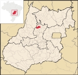
Itapaci
Encyclopedia
| Itapaci | |
|---|---|
| State | Goiás Goiás Goiás is a state of Brazil, located in the central part of the country. The name Goiás comes from the name of an indigenous community... |
| Area: | 956 km² |
| Population: | 16,003 (IBGE 2007) |
| Elevation: | 670 m above sea level |
| Postcode (CEP): | 76360-000 |
| Became a city: | 1945 |
| Microregion: | Ceres Ceres Microregion The Ceres Microregion is located in north-central Goiás state, Brazil. It includes 22 cities with a total population of 215,820 inhabitants . The total area is 13,224.40 km² and the population density is 16.32 inhab/km². The most important cities are Ceres and Goianésia.The most populous... |
| Mayor: | Salvador André de Leandro |
| Distance to Goiânia Goiânia -Climate:The city has a tropical wet and dry climate with an average temperature of . There's a wet season, from October to April, and a dry one, from May to September. Annual rainfall is around 1,520 mm.... : |
230 km |
| Website: | none |
Town
A town is a human settlement larger than a village but smaller than a city. The size a settlement must be in order to be called a "town" varies considerably in different parts of the world, so that, for example, many American "small towns" seem to British people to be no more than villages, while...
and municipality
Municipality
A municipality is essentially an urban administrative division having corporate status and usually powers of self-government. It can also be used to mean the governing body of a municipality. A municipality is a general-purpose administrative subdivision, as opposed to a special-purpose district...
in northern Goiás
Goiás
Goiás is a state of Brazil, located in the central part of the country. The name Goiás comes from the name of an indigenous community...
state, Brazil
Brazil
Brazil , officially the Federative Republic of Brazil , is the largest country in South America. It is the world's fifth largest country, both by geographical area and by population with over 192 million people...
. The population was 16,003 in 2007 (IBGE). The total area of the municipality was 956.1 km² (10/10/2002).
Geography
Itapaci is located on the São Patrício Pequeno River in the Ceres MicroregionCeres Microregion
The Ceres Microregion is located in north-central Goiás state, Brazil. It includes 22 cities with a total population of 215,820 inhabitants . The total area is 13,224.40 km² and the population density is 16.32 inhab/km². The most important cities are Ceres and Goianésia.The most populous...
. The distance to the state capital, Goiânia, is 230 kilometers. Highway connections are made by GO-080 / Nerópolis
Nerópolis
Nerópolis is a small city and municipality in central Goiás state, Brazil.-Location:The municipality is part of the metropolitan region of Goiânia, which is 42 kilometers to the west. It is nationally known as the city of garlic and sweets...
/ São Francisco de Goiás
São Francisco de Goiás
São Francisco de Goiás is a small town and municipality in central Goiás state, Brazil.Municipal boundaries:*North: Jaraguá*South: Petrolina de Goiás*East: Pirenópolis*West: Jesúpolis and Jaraguá...
/ BR-153 / Jaraguá / Rialma
Rialma
Rialma is a small city and municipality in north-central Goiás state, Brazil.-Location and Geography:Rialma is located across the Rio das Almas from Ceres on the important interstate highway BR-153, which links Anápolis to Belém. It was created as part of the urban area of Ceres, which was also...
/ GO-336. See Seplan for the complete list.
Neighboring municipalities are: Crixás
Crixás
Crixás is a small city and municipality in northwestern Goiás state, Brazil. The population was 14,547 in a total area of 4,661.5 km². Crixás was a major gold producing area but is now gradually losing population....
, Guarinos
Guarinos
Guarinos is a small town and municipality in northern Goiás state, Brazil. The population was 2,411 in a total area of 595.8 km² .-Highway Connections:...
, Hidrolina
Hidrolina
Hidrolina is a small town and municipality in north-central Goiás, Brazil. The population was 4,157 and the area of the municipality was 580 km² .-Location:...
, Ipiranga de Goiás
Ipiranga de Goiás
Ipiranga de Goiás is a small town and municipality in north-central Goiás state, Brazil.-Municipal Boundaries:Ipiranga has boundaries with: Ceres, Itapaci, Nova Glória and Rubiataba...
, Nova América
Nova América
Nova América is a small town and municipality in northeastern Goiás state, Brazil.-Location:Nova América is located 71 km. east of Ceres and the important BR-153 highway...
, Nova Glória
Nova Glória
Nova Glória is a small town and municipality in north-central Goiás state, Brazil. It is a large producer of sugarcane.-Location:Nova Glória is in the Ceres Microregion and is north of Goiânia, just east of the important BR-153 highway. It is 21 kilometers north of the important commercial...
, Pilar de Goiás
Pilar de Goiás
Pilar de Goiás is a small town and municipality in north-central Goiás state, Brazil.-Location:Pilar is located 252 kilometers north of the state capital, Goiânia in the Ceres Microregion. It is connected to the south of the state, with its main urban centers, by highway BR-153...
, Rubiataba
Rubiataba
Rubiataba is a small city and municipality in northeastern Goiás state, Brazil.-Location and Geography:Rubiataba is located in the north of the state, south of the source of the Crixás River. It is 235 kilometres to the state capital of Goiânia. Other distances are:*Nova América: 21 km. to the...
and São Luíz do Norte
São Luíz do Norte
São Luís do Norte is a small town and municipality in northeastern Goiás state, Brazil. An alternative spelling is "São Luís do Norte".-Location:São Luís is located 58 km. north of Ceres on the important BR-153 highway....
.
Climate
- The climate is tropical humid with high maximum temperatures that can reach 37 °C. The natural resources of the town are its mineral wealth. There are deposits of mica, crystal, asbestos, and gold. In the forests there are stands of hardwood.
Districts, Villages, and Hamlets
- District: Aparecida de Goiás.
- Village: Ponte Nova.
- Hamlets: Santo Agostinho, São José do Caiamar, Vila Santana and Vila Trindade.
Demographics
- Population density: 16.74 inhab/km² (2007)
- Population growth rate: 1.62% from 1996/2007
- Urban population in 1980: 6,179
- Urban population in 2007: 14,546
- Rural population in 1980: 8,046
- Rural population in 2007: 1,457
The economy
The economy is based on livestock raising, agriculture, and services.In 2006 there were 425 farms with a total area of 51,805 hectares, of which 3,500 hectares were cropland and 38,600 hectares were pasture. Cattle raising is the main economic activity with 75,000 head in 2006. There are plantations of rice, beans, corn, peanuts, and manioc. The main crop was sugarcane with 4,800 ha. planted in 2006 and a production of 384,000 tons.
- Industrial establishments: 24
- Retail commercial establishments: 176
- Distillery: Vale Verde Empreendimentos Agrícolas Ltda. (July/2007)
- Dairy: Goiásminas Indústria de Laticínios Ltda. (22/05/2006)
- Financial institutions: Banco do Brasil S.A., Banco Itaú S.A (22/05/2006)
Health and education
In 2007 there were 12 schools in activity with 5,853 students. There was a campus of the Universidade Estadual de Goiás. The literacy rate was 85.4% in 2000. There were 02 hospitals with 99 beds and 15 doctors. The infant mortality rate was 31.12 in 2000 (in 1,000 live births)- Municipal Human Development IndexHuman Development IndexThe Human Development Index is a composite statistic used to rank countries by level of "human development" and separate "very high human development", "high human development", "medium human development", and "low human development" countries...
: 0.725 - State ranking: 160 (out of 242 municipalities in 2000)
- National ranking: 2,524 (out of 5,507 municipalities in 2000) For the complete list see frigoletto.com.br