
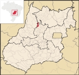
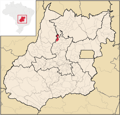
Guarinos
Encyclopedia
| Guarinos | |
|---|---|
| State | Goiás Goiás Goiás is a state of Brazil, located in the central part of the country. The name Goiás comes from the name of an indigenous community... |
| Area: | 596 km² |
| Population: | 2,411 (IBGE 2007) |
| Elevation: | 480 m above sea level |
| Postcode (CEP): | 76385-000 |
| Became a city: | 1989 |
| Microregion: | Ceres Ceres Microregion The Ceres Microregion is located in north-central Goiás state, Brazil. It includes 22 cities with a total population of 215,820 inhabitants . The total area is 13,224.40 km² and the population density is 16.32 inhab/km². The most important cities are Ceres and Goianésia.The most populous... |
| Mayor: | José Ribamar Souza Moraes |
| Distance to Goiânia Goiânia -Climate:The city has a tropical wet and dry climate with an average temperature of . There's a wet season, from October to April, and a dry one, from May to September. Annual rainfall is around 1,520 mm.... : |
270 km |
| Website: | none |
Town
A town is a human settlement larger than a village but smaller than a city. The size a settlement must be in order to be called a "town" varies considerably in different parts of the world, so that, for example, many American "small towns" seem to British people to be no more than villages, while...
and municipality
Municipality
A municipality is essentially an urban administrative division having corporate status and usually powers of self-government. It can also be used to mean the governing body of a municipality. A municipality is a general-purpose administrative subdivision, as opposed to a special-purpose district...
in northern Goiás
Goiás
Goiás is a state of Brazil, located in the central part of the country. The name Goiás comes from the name of an indigenous community...
state, Brazil
Brazil
Brazil , officially the Federative Republic of Brazil , is the largest country in South America. It is the world's fifth largest country, both by geographical area and by population with over 192 million people...
. The population was 2,411 (2007) in a total area of 595.8 km² (10/10/2002).
Highway Connections
Connections are made from GoiâniaGoiânia
-Climate:The city has a tropical wet and dry climate with an average temperature of . There's a wet season, from October to April, and a dry one, from May to September. Annual rainfall is around 1,520 mm....
by GO-080 / Nerópolis
Nerópolis
Nerópolis is a small city and municipality in central Goiás state, Brazil.-Location:The municipality is part of the metropolitan region of Goiânia, which is 42 kilometers to the west. It is nationally known as the city of garlic and sweets...
/ São Francisco de Goiás
São Francisco de Goiás
São Francisco de Goiás is a small town and municipality in central Goiás state, Brazil.Municipal boundaries:*North: Jaraguá*South: Petrolina de Goiás*East: Pirenópolis*West: Jesúpolis and Jaraguá...
/ BR-153 / Jaraguá / Rianápolis
Rianápolis
Rianápolis is a small town and municipality in northeastern Goiás state, Brazil.-Location:It is located almost directly north of the state capital and is on the important BR-153 highway, which links Belem to São Paulo. The regional center of Ceres is located 19 km. to the northwest. Highway...
/ Rialma
Rialma
Rialma is a small city and municipality in north-central Goiás state, Brazil.-Location and Geography:Rialma is located across the Rio das Almas from Ceres on the important interstate highway BR-153, which links Anápolis to Belém. It was created as part of the urban area of Ceres, which was also...
/ GO-336 / Itapaci
Itapaci
Itapaci is a small town and municipality in northern Goiás state, Brazil. The population was 16,003 in 2007 . The total area of the municipality was 956.1 km² .-Geography:...
/ GO-154 / Pilar de Goiás
Pilar de Goiás
Pilar de Goiás is a small town and municipality in north-central Goiás state, Brazil.-Location:Pilar is located 252 kilometers north of the state capital, Goiânia in the Ceres Microregion. It is connected to the south of the state, with its main urban centers, by highway BR-153...
/ GO-439. (18 km unpaved) See Seplan
Neighboring municipalities are Pilar de Goiás
Pilar de Goiás
Pilar de Goiás is a small town and municipality in north-central Goiás state, Brazil.-Location:Pilar is located 252 kilometers north of the state capital, Goiânia in the Ceres Microregion. It is connected to the south of the state, with its main urban centers, by highway BR-153...
, Itapaci
Itapaci
Itapaci is a small town and municipality in northern Goiás state, Brazil. The population was 16,003 in 2007 . The total area of the municipality was 956.1 km² .-Geography:...
, Crixás
Crixás
Crixás is a small city and municipality in northwestern Goiás state, Brazil. The population was 14,547 in a total area of 4,661.5 km². Crixás was a major gold producing area but is now gradually losing population....
, Nova América
Nova América
Nova América is a small town and municipality in northeastern Goiás state, Brazil.-Location:Nova América is located 71 km. east of Ceres and the important BR-153 highway...
, and Santa Terezinha de Goiás
Santa Terezinha de Goiás
Santa Terezinha de Goiás is a small city and municipality in north Goiás state, Brazil. Santa Terezinha is sometimes written as ""Santa Teresinha".-Location:...
Demographics
- Population growth rate: -2.51% from 1996/2007
- Urban population: 1174
- Rural population: 1237.
The economy
The main economic activities were cattle raising, agriculture and services. There were 23 retail units in August 2007. There were only 35 automobiles in 2007, the lowest number in the state. In 2006 there were 363 farms with a total area of 33,095 hectares, of which oly 350 hctares were cropland. The main agricultural activities were cattle raising (26,100 head in 2007), and cultivation of rice, beans, manioc, corn, and bananas. IBGEHealth and education
The literacy rate was 83.3% in 2000, while there were 5 schools with 594 students in 2006. There were no hospitals and only one doctor.The infant mortality rate was 33.15 in 1,000 live births while the score on the MHDI (Municipal Human Development Index was 0.694
The state ranking was 214 (out of 242 municipalities in 2000) and the national ranking was 3,096 (out of 5,507 municipalities in 2000). Data are from 2000. For the complete list see frigoletto.com.br
Sources of Data
See also
List of municipalities in Goiás