
Hidrolina
Encyclopedia
| Hidrolina | |
|---|---|
| State | Goiás Goiás Goiás is a state of Brazil, located in the central part of the country. The name Goiás comes from the name of an indigenous community... |
| Area: | 580 km² |
| Population: | 4,157 (IBGE 2007) |
| Elevation: | 603 m above sea level |
| Postcode (CEP): | 76375-000 |
| Became a city: | 1958 |
| Microregion: | Ceres Ceres Microregion The Ceres Microregion is located in north-central Goiás state, Brazil. It includes 22 cities with a total population of 215,820 inhabitants . The total area is 13,224.40 km² and the population density is 16.32 inhab/km². The most important cities are Ceres and Goianésia.The most populous... |
| Mayor: | Wilton Moreira Alve |
| Distance to Goiânia Goiânia -Climate:The city has a tropical wet and dry climate with an average temperature of . There's a wet season, from October to April, and a dry one, from May to September. Annual rainfall is around 1,520 mm.... : |
267 km |
| Website: | none |
Town
A town is a human settlement larger than a village but smaller than a city. The size a settlement must be in order to be called a "town" varies considerably in different parts of the world, so that, for example, many American "small towns" seem to British people to be no more than villages, while...
and municipality
Municipality
A municipality is essentially an urban administrative division having corporate status and usually powers of self-government. It can also be used to mean the governing body of a municipality. A municipality is a general-purpose administrative subdivision, as opposed to a special-purpose district...
in north-central Goiás
Goiás
Goiás is a state of Brazil, located in the central part of the country. The name Goiás comes from the name of an indigenous community...
, Brazil
Brazil
Brazil , officially the Federative Republic of Brazil , is the largest country in South America. It is the world's fifth largest country, both by geographical area and by population with over 192 million people...
. The population was 4,157 (IBGE 2007) and the area of the municipality was 580 km² (10/10/2002).
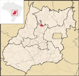
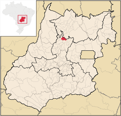
Location
Hidrolina is in the Ceres MicroregionCeres Microregion
The Ceres Microregion is located in north-central Goiás state, Brazil. It includes 22 cities with a total population of 215,820 inhabitants . The total area is 13,224.40 km² and the population density is 16.32 inhab/km². The most important cities are Ceres and Goianésia.The most populous...
north of the state capital, Goiânia
Goiânia
-Climate:The city has a tropical wet and dry climate with an average temperature of . There's a wet season, from October to April, and a dry one, from May to September. Annual rainfall is around 1,520 mm....
. It is 27 kilometers northeast of São Luíz do Norte
São Luíz do Norte
São Luís do Norte is a small town and municipality in northeastern Goiás state, Brazil. An alternative spelling is "São Luís do Norte".-Location:São Luís is located 58 km. north of Ceres on the important BR-153 highway....
, which is on the junction with the important BR-153 highway. There is another dirt road going east for 14 kilometers to Pilar de Goiás
Pilar de Goiás
Pilar de Goiás is a small town and municipality in north-central Goiás state, Brazil.-Location:Pilar is located 252 kilometers north of the state capital, Goiânia in the Ceres Microregion. It is connected to the south of the state, with its main urban centers, by highway BR-153...
. The distance to Goiânia
Goiânia
-Climate:The city has a tropical wet and dry climate with an average temperature of . There's a wet season, from October to April, and a dry one, from May to September. Annual rainfall is around 1,520 mm....
is 267 km. and highway connections are made by GO-080 / Nerópolis
Nerópolis
Nerópolis is a small city and municipality in central Goiás state, Brazil.-Location:The municipality is part of the metropolitan region of Goiânia, which is 42 kilometers to the west. It is nationally known as the city of garlic and sweets...
/ São Francisco de Goiás
São Francisco de Goiás
São Francisco de Goiás is a small town and municipality in central Goiás state, Brazil.Municipal boundaries:*North: Jaraguá*South: Petrolina de Goiás*East: Pirenópolis*West: Jesúpolis and Jaraguá...
/ BR-153 / Jaraguá / Rialma
Rialma
Rialma is a small city and municipality in north-central Goiás state, Brazil.-Location and Geography:Rialma is located across the Rio das Almas from Ceres on the important interstate highway BR-153, which links Anápolis to Belém. It was created as part of the urban area of Ceres, which was also...
/ São Luíz do Norte
São Luíz do Norte
São Luís do Norte is a small town and municipality in northeastern Goiás state, Brazil. An alternative spelling is "São Luís do Norte".-Location:São Luís is located 58 km. north of Ceres on the important BR-153 highway....
/ GO-338. See Seplan
Municipal boundaries are with:
- north: UruaçuUruaçuUruaçu is a small city and municipality in north Goiás state, Brazil.-Geography:Uruaçu is located north of Anápolis and Goiânia on the important interstate highway BR-153, which links Brasília to Belém. It is 269 km. from Goiânia and 244 km. from Brasília...
- south: São Luíz do NorteSão Luíz do NorteSão Luís do Norte is a small town and municipality in northeastern Goiás state, Brazil. An alternative spelling is "São Luís do Norte".-Location:São Luís is located 58 km. north of Ceres on the important BR-153 highway....
- east: Santa Rita do Novo DestinoSanta Rita do Novo DestinoSanta Rita do Novo Destino is a small town and municipality in northeastern Goiás state, Brazil.-Location:Santa Rita do Novo Destino is 82 km. east of Ceres and 15 km. north of Goianésia. Highway connections from Goiânia are made by taking GO-080 / Nerópolis / São Francisco de Goiás / BR-153 /...
- west: Pilar de GoiásPilar de GoiásPilar de Goiás is a small town and municipality in north-central Goiás state, Brazil.-Location:Pilar is located 252 kilometers north of the state capital, Goiânia in the Ceres Microregion. It is connected to the south of the state, with its main urban centers, by highway BR-153...
History
Hidrolina began in 1950 with the donation of lands to the Catholic Church by two local ranchers. A chapel was built in homage to Santo Antonio Maria Claret and soon houses were built. The first name was "Lobeira" due to the existence of this tree in the region. In 1958 it was raised to district and the name changed to Hidrolina, because of the presence of many streams. In the same year it became a municipality.Demographics
- Population density: 7.16 inhab/km² (2007)
- Population growth rate: 0.47% from 1996/2007
- Urban population in 1980: 2,375
- Urban population in 2007: 2,991
- Rural population in 1980: 2,438
- Rural population in 2007: 1,166
The economy
The main economic activities are cattle raising, agriculture and services. In 2007 there were 11 industrial units, 43 retail units and one banking institution. There were 341 automobiles in 2007. Farming was the main economic activity and there were 364 farms in 2006 with a total area of 37,038 hectares, of which 2,800 were cropland and the rest either pasture or woodland. The main agricultural activities were cattle raising (35,000 head in 2006) and cultivation of rice, sugarcane, manioc, corn, soybeans and bananas.Health and education
The literacy rate was 86.3% in 2005 while the infant mortality rate was 31.12 in 1,000 live births, in the same year. There were 07 schoolswith 1,297 students in 2006. In 20073 there was 01 hospital with 29 beds.
Hidrolina was ranked 114 out of 242 municipalities on the Human Development Index
Human Development Index
The Human Development Index is a composite statistic used to rank countries by level of "human development" and separate "very high human development", "high human development", "medium human development", and "low human development" countries...
for the state of Goiás
Goiás
Goiás is a state of Brazil, located in the central part of the country. The name Goiás comes from the name of an indigenous community...
. Life expectancy was 66.4 for males and females. Data are from 2000. For the complete list see frigoletto.com.br
Sources of data
See also
List of municipalities in Goiás