
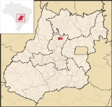
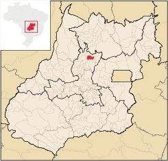
São Luíz do Norte
Encyclopedia
| São Luís do Norte | |
|---|---|
| State | Goiás Goiás Goiás is a state of Brazil, located in the central part of the country. The name Goiás comes from the name of an indigenous community... |
| Area: | 586.0 km² |
| Population: | 4,266 (IBGE 2007) |
| Elevation: | 564m above sea level |
| Postcode (CEP): | 76365-000 |
| IBGE statistical microregion: | 006 Ceres Microregion Ceres Microregion The Ceres Microregion is located in north-central Goiás state, Brazil. It includes 22 cities with a total population of 215,820 inhabitants . The total area is 13,224.40 km² and the population density is 16.32 inhab/km². The most important cities are Ceres and Goianésia.The most populous... |
| Became a city: | 1989 |
| Mayor: | Jacob Ferreira |
| Distance to Goiânia Goiânia -Climate:The city has a tropical wet and dry climate with an average temperature of . There's a wet season, from October to April, and a dry one, from May to September. Annual rainfall is around 1,520 mm.... : |
245 km. |
| Website: | none |
| Coordinates: | 14°51′52"S 49°19′58"W |
Town
A town is a human settlement larger than a village but smaller than a city. The size a settlement must be in order to be called a "town" varies considerably in different parts of the world, so that, for example, many American "small towns" seem to British people to be no more than villages, while...
and municipality
Municipality
A municipality is essentially an urban administrative division having corporate status and usually powers of self-government. It can also be used to mean the governing body of a municipality. A municipality is a general-purpose administrative subdivision, as opposed to a special-purpose district...
in northeastern Goiás
Goiás
Goiás is a state of Brazil, located in the central part of the country. The name Goiás comes from the name of an indigenous community...
state, Brazil
Brazil
Brazil , officially the Federative Republic of Brazil , is the largest country in South America. It is the world's fifth largest country, both by geographical area and by population with over 192 million people...
. An alternative spelling is "São Luís do Norte".
Location
São Luís is located 58 km. north of CeresCeres, Goiás
Ceres is a small city and municipality in central Goiás state, Brazil. It was the first agricultural colony built in the state of Goiás.-Geography:...
on the important BR-153 highway.
- Highway connections from GoiâniaGoiânia-Climate:The city has a tropical wet and dry climate with an average temperature of . There's a wet season, from October to April, and a dry one, from May to September. Annual rainfall is around 1,520 mm....
: GO-080 / NerópolisNerópolisNerópolis is a small city and municipality in central Goiás state, Brazil.-Location:The municipality is part of the metropolitan region of Goiânia, which is 42 kilometers to the west. It is nationally known as the city of garlic and sweets...
/ São Francisco de GoiásSão Francisco de GoiásSão Francisco de Goiás is a small town and municipality in central Goiás state, Brazil.Municipal boundaries:*North: Jaraguá*South: Petrolina de Goiás*East: Pirenópolis*West: Jesúpolis and Jaraguá...
/ BR-153 / Jaraguá / RialmaRialmaRialma is a small city and municipality in north-central Goiás state, Brazil.-Location and Geography:Rialma is located across the Rio das Almas from Ceres on the important interstate highway BR-153, which links Anápolis to Belém. It was created as part of the urban area of Ceres, which was also...
/ 57 km north on BR-153. See Seplan
Neighboring municipalities: Hidrolina
Hidrolina
Hidrolina is a small town and municipality in north-central Goiás, Brazil. The population was 4,157 and the area of the municipality was 580 km² .-Location:...
, Santa Rita do Novo Destino
Santa Rita do Novo Destino
Santa Rita do Novo Destino is a small town and municipality in northeastern Goiás state, Brazil.-Location:Santa Rita do Novo Destino is 82 km. east of Ceres and 15 km. north of Goianésia. Highway connections from Goiânia are made by taking GO-080 / Nerópolis / São Francisco de Goiás / BR-153 /...
, Goianésia
Goianésia
Goianésia is a municipality in the state of Goiás, Brazil. It is a large producer of sugarcane for production of alcohol used as a source of fuel.-Location:...
, Santa Isabel
Santa Isabel
Santa Isabel is the Spanish and Portuguese name of one of two Roman Catholic saints, Saint Isabel of France and Saint Isabel of Aragon. Various places have been named for either of such persons. These include: Argentina:...
, Nova Glória
Nova Glória
Nova Glória is a small town and municipality in north-central Goiás state, Brazil. It is a large producer of sugarcane.-Location:Nova Glória is in the Ceres Microregion and is north of Goiânia, just east of the important BR-153 highway. It is 21 kilometers north of the important commercial...
and Itapaci
Itapaci
Itapaci is a small town and municipality in northern Goiás state, Brazil. The population was 16,003 in 2007 . The total area of the municipality was 956.1 km² .-Geography:...
.
Demographics
- Urban population: 3,557
- Population density: 7.28 inhab/km² (2007)
- Population growth rate: 0.63% 1996/2007
The Economy
The economy is based on subsistence agriculture, cattle raising, services, public administration, and small transformation industries.There was one dairy—G.G. Teixeira e Cia Ltda—in 2007. In 2006 there were 161 farms with a total area of 35,883 hectares, 19,000 hectares being pasture. The cattle herd had 31,000 head in 2007. The main crops were pineapple, sugarcane (5,600 hectares), rice (300 hectares), beans, manioc, corn (300 hectares), and soybeans (3,600 hectares).
Health and Education
In the educational sector there were 6 schools. The adult literacy rate was 80.5% (2000) (national average was 86.4%). There were no hospitals in 2007. The infant mortality rate was 25,32 (2000) (national average was 33.0). The score on the Human Development IndexHuman Development Index
The Human Development Index is a composite statistic used to rank countries by level of "human development" and separate "very high human development", "high human development", "medium human development", and "low human development" countries...
was 0.710.
For the complete list see frigoletto.com.br