
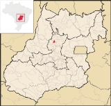
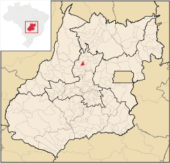
Ipiranga de Goiás
Encyclopedia
| Ipiranga de Goiás | |
|---|---|
| State | Goiás Goiás Goiás is a state of Brazil, located in the central part of the country. The name Goiás comes from the name of an indigenous community... |
| Area: | 241 km² |
| Population: | 2,813 (IBGE 2007) |
| Elevation: | 623 m above sea level |
| Postcode (CEP): | 76304-000 |
| Became a city: | 2001 |
| Microregion: | Ceres Ceres Microregion The Ceres Microregion is located in north-central Goiás state, Brazil. It includes 22 cities with a total population of 215,820 inhabitants . The total area is 13,224.40 km² and the population density is 16.32 inhab/km². The most important cities are Ceres and Goianésia.The most populous... |
| Mayor: | Geraldo Ferreira de Oliveira |
| Distance to Goiânia Goiânia -Climate:The city has a tropical wet and dry climate with an average temperature of . There's a wet season, from October to April, and a dry one, from May to September. Annual rainfall is around 1,520 mm.... : |
219 km |
| Website: | none |
Town
A town is a human settlement larger than a village but smaller than a city. The size a settlement must be in order to be called a "town" varies considerably in different parts of the world, so that, for example, many American "small towns" seem to British people to be no more than villages, while...
and municipality
Municipality
A municipality is essentially an urban administrative division having corporate status and usually powers of self-government. It can also be used to mean the governing body of a municipality. A municipality is a general-purpose administrative subdivision, as opposed to a special-purpose district...
in north-central Goiás
Goiás
Goiás is a state of Brazil, located in the central part of the country. The name Goiás comes from the name of an indigenous community...
state, Brazil
Brazil
Brazil , officially the Federative Republic of Brazil , is the largest country in South America. It is the world's fifth largest country, both by geographical area and by population with over 192 million people...
.
Municipal Boundaries
Ipiranga has boundaries with: CeresCeres, Goiás
Ceres is a small city and municipality in central Goiás state, Brazil. It was the first agricultural colony built in the state of Goiás.-Geography:...
, Itapaci
Itapaci
Itapaci is a small town and municipality in northern Goiás state, Brazil. The population was 16,003 in 2007 . The total area of the municipality was 956.1 km² .-Geography:...
, Nova Glória
Nova Glória
Nova Glória is a small town and municipality in north-central Goiás state, Brazil. It is a large producer of sugarcane.-Location:Nova Glória is in the Ceres Microregion and is north of Goiânia, just east of the important BR-153 highway. It is 21 kilometers north of the important commercial...
and Rubiataba
Rubiataba
Rubiataba is a small city and municipality in northeastern Goiás state, Brazil.-Location and Geography:Rubiataba is located in the north of the state, south of the source of the Crixás River. It is 235 kilometres to the state capital of Goiânia. Other distances are:*Nova América: 21 km. to the...
. Ipiranga is 219 kilometers from the state capital, Goiânia
Goiânia
-Climate:The city has a tropical wet and dry climate with an average temperature of . There's a wet season, from October to April, and a dry one, from May to September. Annual rainfall is around 1,520 mm....
.
Highway Connections from Goiânia
Highway connections from Goiânia are made by GO-080 / NerópolisNerópolis
Nerópolis is a small city and municipality in central Goiás state, Brazil.-Location:The municipality is part of the metropolitan region of Goiânia, which is 42 kilometers to the west. It is nationally known as the city of garlic and sweets...
/ São Francisco de Goiás
São Francisco de Goiás
São Francisco de Goiás is a small town and municipality in central Goiás state, Brazil.Municipal boundaries:*North: Jaraguá*South: Petrolina de Goiás*East: Pirenópolis*West: Jesúpolis and Jaraguá...
/ BR-153 / Jaraguá / Rialma
Rialma
Rialma is a small city and municipality in north-central Goiás state, Brazil.-Location and Geography:Rialma is located across the Rio das Almas from Ceres on the important interstate highway BR-153, which links Anápolis to Belém. It was created as part of the urban area of Ceres, which was also...
/ GO-434.
History
The history of Ipiranga de Goiás is connected to the decree of 1941 creating the agricultural colony called Colonia Agrícola Nacional de Goiás, administered by the engineer Bernardo Sayão. In 1949 the dentist Raimundo Alves de Souza arrived with his family and fought to make a city out of Ipiranga. In 1956 he acquired lands and divided them into lots to attract settlers. Ipiranga became a district of CeresCeres, Goiás
Ceres is a small city and municipality in central Goiás state, Brazil. It was the first agricultural colony built in the state of Goiás.-Geography:...
in 1968 and became a municipality in 1998. See Ipiranga de Goiás for the history.
Demographics
- Population density: 11.65 inhab/km² (2007)
- Total population in 2001: 2,804
- Total population in 2007: 2,813
- Urban population in 2007: 843
- Rural population in 2007: 1,970
- Population growth rate: n/a
The economy
The main economic activities are cattle raising and agriculture. There were 416 farms in 2006 with a total area of 18,494 hectares, of which 5,400 hectares were cropland and 11,683 hectares were pasture. There were 23,000 head of cattle in 2006. The main crops were rice, sugarcane (3,300 hectares), manioc, corn, and beans.- Automobiles: 141 in 2007 IBGE
Health and education
There were 06 schools in 2006 with 688 students. There were no hospitals. There are no data available on the Municipal uman Development Index).Sources of Data
See also
List of municipalities in Goiás