
Nova Glória
Encyclopedia
| Nova Glória | |
|---|---|
| State | Goiás Goiás Goiás is a state of Brazil, located in the central part of the country. The name Goiás comes from the name of an indigenous community... |
| Area: | 413 km² |
| Population: | 8,470 (IBGE 2007) |
| Elevation: | 562 m above sea level |
| Postcode (CEP): | 76305-000 |
| Became a city: | 1980 |
| Distance to Goiânia Goiânia -Climate:The city has a tropical wet and dry climate with an average temperature of . There's a wet season, from October to April, and a dry one, from May to September. Annual rainfall is around 1,520 mm.... : |
206 km |
| Statistical microregion | Ceres Ceres Microregion The Ceres Microregion is located in north-central Goiás state, Brazil. It includes 22 cities with a total population of 215,820 inhabitants . The total area is 13,224.40 km² and the population density is 16.32 inhab/km². The most important cities are Ceres and Goianésia.The most populous... |
| Website: | Prefeitura Municipal de Rialma |
Town
A town is a human settlement larger than a village but smaller than a city. The size a settlement must be in order to be called a "town" varies considerably in different parts of the world, so that, for example, many American "small towns" seem to British people to be no more than villages, while...
and municipality
Municipality
A municipality is essentially an urban administrative division having corporate status and usually powers of self-government. It can also be used to mean the governing body of a municipality. A municipality is a general-purpose administrative subdivision, as opposed to a special-purpose district...
in north-central Goiás
Goiás
Goiás is a state of Brazil, located in the central part of the country. The name Goiás comes from the name of an indigenous community...
state, Brazil
Brazil
Brazil , officially the Federative Republic of Brazil , is the largest country in South America. It is the world's fifth largest country, both by geographical area and by population with over 192 million people...
. It is a large producer of sugarcane.
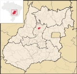
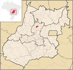
Location
Nova Glória is in the Ceres MicroregionCeres Microregion
The Ceres Microregion is located in north-central Goiás state, Brazil. It includes 22 cities with a total population of 215,820 inhabitants . The total area is 13,224.40 km² and the population density is 16.32 inhab/km². The most important cities are Ceres and Goianésia.The most populous...
and is north of Goiânia
Goiânia
-Climate:The city has a tropical wet and dry climate with an average temperature of . There's a wet season, from October to April, and a dry one, from May to September. Annual rainfall is around 1,520 mm....
, just east of the important BR-153 highway. It is 21 kilometers north of the important commercial center, Ceres
Ceres, Goiás
Ceres is a small city and municipality in central Goiás state, Brazil. It was the first agricultural colony built in the state of Goiás.-Geography:...
. Nearby towns are Itapaci
Itapaci
Itapaci is a small town and municipality in northern Goiás state, Brazil. The population was 16,003 in 2007 . The total area of the municipality was 956.1 km² .-Geography:...
, 25 km to the north; Rubiataba
Rubiataba
Rubiataba is a small city and municipality in northeastern Goiás state, Brazil.-Location and Geography:Rubiataba is located in the north of the state, south of the source of the Crixás River. It is 235 kilometres to the state capital of Goiânia. Other distances are:*Nova América: 21 km. to the...
, 24 km. to the west; and Rialma
Rialma
Rialma is a small city and municipality in north-central Goiás state, Brazil.-Location and Geography:Rialma is located across the Rio das Almas from Ceres on the important interstate highway BR-153, which links Anápolis to Belém. It was created as part of the urban area of Ceres, which was also...
, 21 km. to the south. The important BR 153 highway is 3 km. to the east.
The distance to Goiânia
Goiânia
-Climate:The city has a tropical wet and dry climate with an average temperature of . There's a wet season, from October to April, and a dry one, from May to September. Annual rainfall is around 1,520 mm....
is 206 km. Highway connections are made by GO-080 / Nerópolis
Nerópolis
Nerópolis is a small city and municipality in central Goiás state, Brazil.-Location:The municipality is part of the metropolitan region of Goiânia, which is 42 kilometers to the west. It is nationally known as the city of garlic and sweets...
/ São Francisco de Goiás
São Francisco de Goiás
São Francisco de Goiás is a small town and municipality in central Goiás state, Brazil.Municipal boundaries:*North: Jaraguá*South: Petrolina de Goiás*East: Pirenópolis*West: Jesúpolis and Jaraguá...
/ BR-153 / Jaraguá / Rialma
Rialma
Rialma is a small city and municipality in north-central Goiás state, Brazil.-Location and Geography:Rialma is located across the Rio das Almas from Ceres on the important interstate highway BR-153, which links Anápolis to Belém. It was created as part of the urban area of Ceres, which was also...
/ GO-434. See Seplan
Municipal boundaries are with:
- north: ItapaciItapaciItapaci is a small town and municipality in northern Goiás state, Brazil. The population was 16,003 in 2007 . The total area of the municipality was 956.1 km² .-Geography:...
and São Luíz do NorteSão Luíz do NorteSão Luís do Norte is a small town and municipality in northeastern Goiás state, Brazil. An alternative spelling is "São Luís do Norte".-Location:São Luís is located 58 km. north of Ceres on the important BR-153 highway.... - south: CeresCeres, GoiásCeres is a small city and municipality in central Goiás state, Brazil. It was the first agricultural colony built in the state of Goiás.-Geography:...
, RialmaRialmaRialma is a small city and municipality in north-central Goiás state, Brazil.-Location and Geography:Rialma is located across the Rio das Almas from Ceres on the important interstate highway BR-153, which links Anápolis to Belém. It was created as part of the urban area of Ceres, which was also...
and Santa IsabelSanta Isabel, Goiás-Location:Santa Isabel is a small town and municipality in north-central Goiás state, Brazil. It is 21 kilometers from Ceres, the nearest regional center. Santa Isabel has municipal boundaries with Rubiataba, Itapaci, Nova Glória, Rialma, and Carmo do Rio Verde... - east: CeresCeres, GoiásCeres is a small city and municipality in central Goiás state, Brazil. It was the first agricultural colony built in the state of Goiás.-Geography:...
- west: Santa IsabelSanta Isabel, Goiás-Location:Santa Isabel is a small town and municipality in north-central Goiás state, Brazil. It is 21 kilometers from Ceres, the nearest regional center. Santa Isabel has municipal boundaries with Rubiataba, Itapaci, Nova Glória, Rialma, and Carmo do Rio Verde...
Political Information
In January 2005 the Mayor was Carlos Luiz de Oliveira. There were 9 city-council members and 7,060 eligible voters in 2007.Demographic Information
In 2007 the population density was 20.51 inhab/km². There were 5,482 inhabitants in the urban area and 2,988 in the rural area. The population has increased by about 700 inhabitants since 1991.Economic Information
The economy was based on agriculture, cattle raising, services, public administration and modest transformation industries. In 2007 there were 12 industrial installations and 86 retail units. There was one financial institution: BRADESCO S.A. Transformation industries were the largest employers with 262 workers, followed by commerce with 219.In 2007 there were 613 automobiles.
In 2006 there were 463 farms with a total area of 25.192 hectares, of which 6,600 hectares were farmland and 17,200 hectares were pasture. In 2004 there were 39,000 head of cattle, 20,000 head of poultry, and 2,400 head of swine. The main agricultural products were pineapple, peanuts, rice, sugarcane (4,900 hectares), beans, manioc, watermelon, corn, and tomatoes.
Health and education
In 2007 there was 1 hospital, with 70 beds, and 4 walk-in health clinics. In 2000 the infant mortality rate was 25.06, below the national average of 33.0.In 2005 the school system had 16 schools, 80 classrooms, 129 teachers, and 2,226 students. In 2000 the adult literacy rate was 83.0%, lower than the national average of 86.4%.
Ranking on the Municipal Human Development Index
Human Development Index
The Human Development Index is a composite statistic used to rank countries by level of "human development" and separate "very high human development", "high human development", "medium human development", and "low human development" countries...
- MHDI: 0.724
- State ranking: 161 (out of 242 municipalities)
- National ranking: 2,532 (out of 5,507 municipalities)
For the complete list see frigoletto.com.br