
Pilar de Goiás
Encyclopedia
| Pilar de Goiás | |
|---|---|
| State | Goiás Goiás Goiás is a state of Brazil, located in the central part of the country. The name Goiás comes from the name of an indigenous community... |
| Area: | 907 km² |
| Population: | 2,852 (IBGE 2007) |
| Elevation: | 753 m above sea level |
| Postcode (CEP): | 76370-000 |
| Became a city: | 1953 |
| Distance to Goiânia Goiânia -Climate:The city has a tropical wet and dry climate with an average temperature of . There's a wet season, from October to April, and a dry one, from May to September. Annual rainfall is around 1,520 mm.... : |
2522 km |
| Website: | Prefeitura Municipal de Rialma |
Town
A town is a human settlement larger than a village but smaller than a city. The size a settlement must be in order to be called a "town" varies considerably in different parts of the world, so that, for example, many American "small towns" seem to British people to be no more than villages, while...
and municipality
Municipality
A municipality is essentially an urban administrative division having corporate status and usually powers of self-government. It can also be used to mean the governing body of a municipality. A municipality is a general-purpose administrative subdivision, as opposed to a special-purpose district...
in north-central Goiás
Goiás
Goiás is a state of Brazil, located in the central part of the country. The name Goiás comes from the name of an indigenous community...
state, Brazil
Brazil
Brazil , officially the Federative Republic of Brazil , is the largest country in South America. It is the world's fifth largest country, both by geographical area and by population with over 192 million people...
.
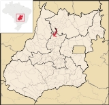
Location
Pilar is located 252 kilometers north of the state capital, GoiâniaGoiânia
-Climate:The city has a tropical wet and dry climate with an average temperature of . There's a wet season, from October to April, and a dry one, from May to September. Annual rainfall is around 1,520 mm....
in the Ceres Microregion
Ceres Microregion
The Ceres Microregion is located in north-central Goiás state, Brazil. It includes 22 cities with a total population of 215,820 inhabitants . The total area is 13,224.40 km² and the population density is 16.32 inhab/km². The most important cities are Ceres and Goianésia.The most populous...
. It is connected to the south of the state, with its main urban centers, by highway BR-153. Highway connections from Goiânia
Goiânia
-Climate:The city has a tropical wet and dry climate with an average temperature of . There's a wet season, from October to April, and a dry one, from May to September. Annual rainfall is around 1,520 mm....
are made by GO-080 / Nerópolis
Nerópolis
Nerópolis is a small city and municipality in central Goiás state, Brazil.-Location:The municipality is part of the metropolitan region of Goiânia, which is 42 kilometers to the west. It is nationally known as the city of garlic and sweets...
/ São Francisco de Goiás
São Francisco de Goiás
São Francisco de Goiás is a small town and municipality in central Goiás state, Brazil.Municipal boundaries:*North: Jaraguá*South: Petrolina de Goiás*East: Pirenópolis*West: Jesúpolis and Jaraguá...
/ BR-153 / Jaraguá / Rialma
Rialma
Rialma is a small city and municipality in north-central Goiás state, Brazil.-Location and Geography:Rialma is located across the Rio das Almas from Ceres on the important interstate highway BR-153, which links Anápolis to Belém. It was created as part of the urban area of Ceres, which was also...
/ GO-336 / Itapaci
Itapaci
Itapaci is a small town and municipality in northern Goiás state, Brazil. The population was 16,003 in 2007 . The total area of the municipality was 956.1 km² .-Geography:...
/ GO-154. See Seplan
Neighboring municipalities are:
- north: Santa Terezinha de GoiásSanta Terezinha de GoiásSanta Terezinha de Goiás is a small city and municipality in north Goiás state, Brazil. Santa Terezinha is sometimes written as ""Santa Teresinha".-Location:...
and Nova Iguaçu de GoiásNova Iguaçu de GoiásNova Iguaçu de Goiás is a small town and municipality in north Goiás state, Brazil.-Location:Nova Iguaçu de Goiás is located in the extreme north of the state and is 136 km from the regional center of Porangatu. Other towns nearby are Campinorte, 28 km. to the east; Alto Horizonte,... - south: ItapaciItapaciItapaci is a small town and municipality in northern Goiás state, Brazil. The population was 16,003 in 2007 . The total area of the municipality was 956.1 km² .-Geography:...
- east: HidrolinaHidrolinaHidrolina is a small town and municipality in north-central Goiás, Brazil. The population was 4,157 and the area of the municipality was 580 km² .-Location:...
- west: GuarinosGuarinosGuarinos is a small town and municipality in northern Goiás state, Brazil. The population was 2,411 in a total area of 595.8 km² .-Highway Connections:...
The terrain is rugged and is crossed by the Vermelho, Peixe, and Taquaraçu rivers.
Political and Demographic Information
In January 2005 the Mayor on record was Waltenir Soares Batista. There were 9 city council members and 2,408 eligible voters (December 2007).In 2007 the population density was 3.15 inhab/km². The urban population was 1,121 (2007) and the rural population was 1,731. The population has decreased about 7,000 people since 1980, with most of the lost inhabitants leaving the rural zone.
Economic, Educational, and Health Information
The economy is based on mining, agriculture, cattle raising, services, public administration, and small transformation industries. There were 13 commercial units in 2007 and no bank agencies. In 2007 there were 128 automobiles.In 2006 there were 473 farms with a total area of 45,548 hectares, of which 1,136 hectares were farmland and 30,606 hectares were pasture. The cattle herd consisted of 62,000 head (2006)and the main crops were rice, bananas, beans, manioc and corn.
Health and education
There were 14 primary schools in 2006 with 727 students. The adult literacy rate was 86.5% in 2000 with the national average being 86.4%.There were no hospitals in 2005 and only 2 doctors. The infant mortality rate was 33.15 (2000) (national average was 33.0).
- Municipal Human Development IndexHuman Development IndexThe Human Development Index is a composite statistic used to rank countries by level of "human development" and separate "very high human development", "high human development", "medium human development", and "low human development" countries...
: 0.700 - State ranking: 209 (out of 242 municipalities)
- National ranking: 2984 (out of 5507 municipalities)
For the complete list see frigoletto.com.br
History
The city is one of the oldest in the state having been settled in 1741 when explorers came looking for gold in the rivers. There is still a historical part of the town with mansions, plazas, monuments and colonial churches.The period of prosperity lasted for forty years. When the gold ran out Vila Pilar survived because of the sugar cane mills, and small plantations. Soon it was abandoned and it lost even its name, being called Itacê, district of Itapaci
Itapaci
Itapaci is a small town and municipality in northern Goiás state, Brazil. The population was 16,003 in 2007 . The total area of the municipality was 956.1 km² .-Geography:...
. In 1953 it regained its name and became a city. The population has decreased greatly since 1980—from 9,246 to 2,852—and the tendency is continuing.
See also
Sources of Data
External Links